
Weldon Canyon Photos


You might also consider
More like Weldon Canyon
Recommended Reviews - Weldon Canyon
Start your review...

5 years ago
6 years ago
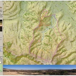
For a detailed view of this trail, please click on my YouTube channel RobbieGarnz at the following link: https://www.youtube.com/watch?v=pedRMX5xCNs Actually, I started at the East Canyon and Rice Canyon trail head and made the trek to Mission Point. However, when I did the East Canyon to the junction trail a couple days prior, I accidentally went onto Weldon Motorway (without knowing what it was!) and wound up backtracking to the end of East Canyon trail. For a review of that hike, check out this link: https://www.youtube.com/watch?v=Sss7bqLB8Gw As for the trek to Mission Peak, be prepared to be flexible! Once you reach the fenced in area at the trail junction about .6 miles north of the East Canyon/Weldon Motorway intersection, there is a rather steep decline. Then, all of a sudden, you run into a locked gate that prevents you from continuing on the primary trail. However, if you walk to the left and slightly down hill, there is a "path" from foot traffic that allows you to go around the sealed off area. I would strongly advise a good pair of hiking boots though, because there is significantly tall grass. A hiking pole would also be a good idea because you never know what could be hiding in that grass! Once you are past that obstacle, the trail slopes downward and then up slightly, and across the ridge for the next mile. You will come to two more gates about 600-800 meters apart. The first one was open when I went, the second was not. There is a sign for Mission Peak on the fence, but the arrow points in both direction. I spent quite a bit of time tromping around the area to figure out a way around and up. Spoiler alert, do not go into the grass on the northeast side above the fence--it only leads to a shear cliff! However, if you turn left (NW) at the gate, the trail continues downhill, which is counter intuitive because you're trying to go up. However, about 250 meters down the hill, on the right, there is a small footpath that traverses the hill side upwards and keeps you away from the restricted area. Once you get on the path, keep going! You will come out on the other side of the fenced in area onto the main trail. From there you are treated to a beautiful view for the next 3/4 of a mile until you hit a fork in the trail. Turn right at the fork and keep going uphill (although I did see some hikers coming up from the other side and we wound up meeting at the top..). The final climb is a great push but well worth it. There is a 360 degree view of unbelievable scenery overlooking the valley. There is also a monument, the widowers bench, and a stack of rocks that has remained undisturbed for quite some time. Coming down is also a joy as you get to relive the awesome view until you get sucked back into the firebreak and remember that you still have to tromp through tall grass to get around the same obstacles you faced coming up. Would be 5 stars if not for that inconvenience! For a detailed review of the hike, check out this link: https://www.youtube.com/watch?v=pedRMX5xCNs You can subscribe and see other epic hiking and fitness videos at this link: https://www.youtube.com/channel/UCSnBYnWYktiqxynCwGrak1Q?view_as=subscriber read more
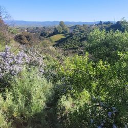
This hidden gem is located right outside the entrance to the Oak Tree Gun Club. It's tucked away and a little hard to find but definitely worth the trip. The best way to get to it is to take the Old Road to Weldon Canyon (it's the bridge that goes over the 5 freeway) and then take a right on Coltrane Ave. The entrance will be off to the left. You'll have to park on the dirt along Coltrane Ave. The trail kicks your butt early with a fairly steep incline for about half a mile. It traverses around the front side of the mountain and eventually leads to the backside. The path is wide and well shaded. The are tons of young oak trees and lush vegetation. Part of the ground floor of the trail feels as if you are running on soft clay. When you get to the top of the mountain you'll have great views of the Alison Canyon. You'll also be able to view the eventual construction of the Aliso Canyon storage field and the proposed natural substation. Apparently they will be updating the equipment they use to power, pump and store natural gas deep underground. A good goal would be to hike to the scenic viewpoint with the bench and the wooden trellis. That would be a 3 mile round trip hike. The trail continues along Weldon Canyon Mtwy. You can take it to East Canyon Mtwy and then you eventually end up at the East and Rice Canyon trailhead. Your hiking partner can leave their car at this location so you don't have to backtrack. read more


More info about Weldon Canyon
22945 Coltrane Ave
Newhall, CA 91321
Directions
Hours
Outdoor Amenities
You might also consider


Weldon Canyon - hiking - Updated July 2026
Best of Newhall
Browse Nearby
BEST of Newhall, California Restaurants near Weldon Canyon
BEST of Newhall, California Coffee near Weldon Canyon
BEST of Newhall, California Things to Do near Weldon Canyon
BEST of Newhall, California Parks near Weldon Canyon
BEST of Newhall, California Breakfast near Weldon Canyon


