Haskell Canyon Trail Hiking Photos


You might also consider
More like Haskell Canyon Trail
Recommended Reviews - Haskell Canyon Trail
Start your review...

Reviews With Photos

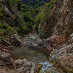
This trail is a mountain biker's dream and an acrophobic's nightmare. There are two entrances to Haskell Canyon Trails. The east entrance starts out with a huge upwards climb and the west entrance starts you at the ground floor where you walk a twisted trail between two mountains. I recommend starting at the east entrance so you can conquer the big hill with your early energy. The top can be a little intimidating if you are scared of heights. When you reach the top proceed left to complete the loop. Try and see if you can spot the low maintenance giraffe in the distance. As you proceed to the lower loop you will notice a number of mountain bike obstacles. Some mystery person went to great lengths to install an awesome and treacherous mountain bike course. I'm sure that people who are into those sort of things love it. I treasure my intact bones so I think I'll stick with hiking instead. This hike reminded me of my favorite Richard Nixon quote, "Only if you have been in the deepest valley can you ever know how magnificent it is to be on the highest mountain." This trail definitely takes you on that journey.

Mountain Biking Trail(s) for: beginners & intermediate riders Directions: - Exit 5 freeway at Rye Canyon then it turns in to Copper Hill. - Take Copper Hill until you get to Haskell Canyon Road. - Go past Walgreens (left side) and there is a turn into a dirt road CONS: - you're riding beneath several power lines and can actually hear the noisy electrical currents...yiiiiiiikes!

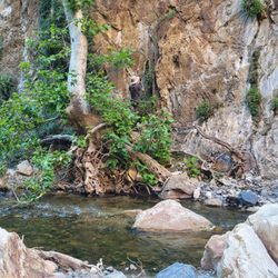
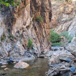
Haskell Canyon is a nice hiking spot in the city of Santa Clarita. It is in Saugus and away from the downtown of Newhall. The trail has a few different paths to take with one being easy and the other providing more of a strenuous hike. You will be able to get great views of the Santa Clarita Valley once you reach the top. No shade on this trail so prepare wisely. read more


This place is pretty straight forward. This is a hiking trail and mountain biking trail. There are like 3 different ways to 4 to 5 different ways to get into and out of the trail. Just an FYI, if you go in through the main entrance and decide to take the path around to another exit be warned that there are some pretty steep hills to go down near the end. And I did see a mattress and a used condom lying a round by one of the exits of the trail but hey.. sometimes the moment just can't wait right?? The answer is yes... it can wait... don't have sex on a dirty, disgusting mattress next to a hiking trail. That's weird and gross. This was cleaned up within weeks btw.. Also.. watch out mountain bikers!! They come down the hill at a very high rate of speed and might not be able to avoid you in time if you are walking/running around a corner. If you are a walker while texting just be sure to stay alert! There is also a good sized staircase a few hundred yards inside the entrance which is nice to use for workouts as well. Also watch out for snakes, they are common here. This place is quiet on weekdays but a bit busier on weekends. It's peaceful and I love coming here to Meditate a few times a week. I like it. It's a hike trail, how could it get anything but a 5 star?? read more


aaahhh I love this trail so much!! It's beautiful at all times of the day but even more during sunset. It's a very easy trail & eventually leads you to Central Park. This trail is perfect for you if you're looking for a nice scenic route to take. read more


7 years ago
This trail is a mountain biker's dream and an acrophobic's nightmare. There are two entrances to Haskell Canyon Trails. The east entrance starts out with a huge upwards climb and the west entrance starts you at the ground floor where you walk a twisted trail between two mountains. I recommend starting at the east entrance so you can conquer the big hill with your early energy. The top can be a little intimidating if you are scared of heights. When you reach the top proceed left to complete the loop. Try and see if you can spot the low maintenance giraffe in the distance. As you proceed to the lower loop you will notice a number of mountain bike obstacles. Some mystery person went to great lengths to install an awesome and treacherous mountain bike course. I'm sure that people who are into those sort of things love it. I treasure my intact bones so I think I'll stick with hiking instead. This hike reminded me of my favorite Richard Nixon quote, "Only if you have been in the deepest valley can you ever know how magnificent it is to be on the highest mountain." This trail definitely takes you on that journey. read more


17 years ago
Mountain Biking Trail(s) for: beginners & intermediate riders Directions: - Exit 5 freeway at Rye Canyon then it turns in to Copper Hill. - Take Copper Hill until you get to Haskell Canyon Road. - Go past Walgreens (left side) and there is a turn into a dirt road CONS: - you're riding beneath several power lines and can actually hear the noisy electrical currents...yiiiiiiikes! read more

8 years ago
13 years ago
This trail was one of the most amazing adventures I've been on so far. We went out to run the 2.5 mile loop trail on Saturday at about 6:30 am. The sun was just rising and the temp was a nice 60 degrees. I had no idea what I was in store for. At the base of the mount the elevation is about 1400 ft. the goal is to make it up the face of the mount where at the top it elevates to about 1800 ft!!!! Amazing. Once I hit the top after crawling about 100 yards, My calves burned like someone lit a fire to them. The descent is awesome and that's where we started running down. I definitely recommend this trail for walking/running, whichever you prefer. You have some amazing views from the top. Next time I'll bring my camera. read more

11 years ago
More info about Haskell Canyon Trail
Santa Clarita, CA 91350
Directions
Hours
Outdoor Amenities
Ask the Community - Haskell Canyon Trail
Review Highlights - Haskell Canyon Trail
You might also consider


Haskell Canyon Trail - hiking - Updated May 2026
Best of Santa Clarita
People found Haskell Canyon Trail by searching for…
Beautiful Views in Santa Clarita, California
Hiking Trails in Santa Clarita, California
Scenic View in Santa Clarita, California
Scenic Overlook in Santa Clarita, California
Scenic Drive in Santa Clarita, California
Parks in Santa Clarita, California
Places to Take Pictures in Santa Clarita, California
Off Road Trails in Santa Clarita, California
Running Trails in Santa Clarita, California
Stargazing in Santa Clarita, California
Watch Sunset in Santa Clarita, California
Walking Trails in Santa Clarita, California
Photo Spots in Santa Clarita, California
Easy Hikes in Santa Clarita, California
Things to Do for Kids in Santa Clarita, California
Sunset View in Santa Clarita, California
Romantic Views in Santa Clarita, California
Views in Santa Clarita, California
Mountain Biking in Santa Clarita, California
Shaded Hike in Santa Clarita, California
Secluded Spots in Santa Clarita, California
Trail in Santa Clarita, California
Trending Searches in Santa Clarita, CA
Boat Rental near Haskell Canyon Trail
Botanical Gardens near Haskell Canyon Trail
Bounce House Rentals near Haskell Canyon Trail
Campgrounds near Haskell Canyon Trail
Cherry Picking near Haskell Canyon Trail
Cliff Jumping near Haskell Canyon Trail
Dog Friendly Things To Do near Haskell Canyon Trail
Flower Fields near Haskell Canyon Trail
Flower Shop near Haskell Canyon Trail
Garage Sales near Haskell Canyon Trail
Hair near Haskell Canyon Trail
Lakes & Ponds near Haskell Canyon Trail
Nurseries & Gardening near Haskell Canyon Trail
Outdoor Activities near Haskell Canyon Trail
Outdoor Furniture Stores near Haskell Canyon Trail
Party Equipment Rentals near Haskell Canyon Trail
Pedicure near Haskell Canyon Trail
Pick Your Own Farms near Haskell Canyon Trail
Picnic Areas near Haskell Canyon Trail
Places To Take Pictures near Haskell Canyon Trail
Plant Nursery near Haskell Canyon Trail
Rock Quarry near Haskell Canyon Trail
Running Trails near Haskell Canyon Trail
Scenic Drive near Haskell Canyon Trail
Secret Spots near Haskell Canyon Trail
Strawberry Picking near Haskell Canyon Trail
Sunrise View near Haskell Canyon Trail
Swimming Holes near Haskell Canyon Trail
Browse Articles
Browse Nearby
BEST of Santa Clarita, California Restaurants near Haskell Canyon Trail
BEST of Santa Clarita, California Coffee near Haskell Canyon Trail
BEST of Santa Clarita, California Things to Do near Haskell Canyon Trail
BEST of Santa Clarita, California Walking Trails near Haskell Canyon Trail
BEST of Santa Clarita, California Parks near Haskell Canyon Trail
BEST of Santa Clarita, California Breakfast near Haskell Canyon Trail
BEST of Santa Clarita, California Campgrounds near Haskell Canyon Trail
BEST of Santa Clarita, California Sightseeing near Haskell Canyon Trail
BEST of Santa Clarita, California Visitor Centers near Haskell Canyon Trail
Browse Brands
Related Searches in Santa Clarita, CA
Best Fishing Locations and Guides in Santa Clarita, California
Best Nature Trails for Hiking in Santa Clarita, California
Best Places for Horseback Riding in Santa Clarita, California
Best Waterfalls and Swimming Holes in Santa Clarita, California
Check Out Off Road Trails in Santa Clarita, California
Discover Dog Friendly Trails to Explore in Santa Clarita, California
Discover Kid Friendly Hiking Trails in Santa Clarita, California
Discover Scenic Hiking Trails in Santa Clarita, California
Discover Scenic Mountain Bike Trails Near Santa Clarita, California
Discover Scenic Waterfall Spots in Santa Clarita, California
Discover Walking Parks in Santa Clarita, California Near You
Discover a Hiking Trail in Santa Clarita, California
Discover the Best Night Hike Trails in Santa Clarita, California
Discover the Best Running Track in Santa Clarita, California
Dog-Friendly Hikes With Dogs in Santa Clarita, California
Enjoy Camping Adventures Around Santa Clarita, California
Enjoy Exciting Mountain Biking Adventures in Santa Clarita, California
Enjoy Kayaking Adventures in Santa Clarita, California
Enjoy Tent Camping Spots Around Santa Clarita, California
Enjoy a Beautiful Waterfall Hike in Santa Clarita, California
Enjoy a Peaceful Nature Walk in Santa Clarita, California
Enjoy the Best Walking Path in Santa Clarita, California
Enjoy the Best Walking Trails in Santa Clarita, California
Exciting Cliff Jumping Spots in Santa Clarita, California
Explore Beautiful Parks and Green Spaces in Santa Clarita, California
Explore Easy Hikes Perfect for All in Santa Clarita, California
Explore Fun Activities to Do in Santa Clarita, California
Explore Popular Campgrounds Near Santa Clarita, California
Explore the Best Beach Spots in Santa Clarita, California
Explore the Best Swimming Holes Around Santa Clarita, California
Explore the Best Trail Options in Santa Clarita, California
Family Friendly Hiking With Kids in Santa Clarita, California
Find Beautiful Views in Santa Clarita, California
Find Parks and Recreation Activities in Santa Clarita, California
Find the Best Parks for Picnics in Santa Clarita, California
Find the Best Scenic View Locations in Santa Clarita, California
Great Places to Walk in Santa Clarita, California
Hike the Popular Waterfall Trail in Santa Clarita, California
Hiking Trails With Waterfalls in Santa Clarita, California
Plan a Scenic Drive Route Near Santa Clarita, California
Popular Outdoor Activities to Try in Santa Clarita, California
Popular Picnic Spots to Visit in Santa Clarita, California
Safe River Swimming Areas in Santa Clarita, California
Safe and Fun Parks for Kids in Santa Clarita, California
Top Climbing Spots and Gyms in Santa Clarita, California
Top Running Trails to Explore in Santa Clarita, California
Top Swimming Lakes to Enjoy in Santa Clarita, California
Top Swimming Spots and Pools in Santa Clarita, California
Walk Dog Friendly Hiking Trails in Santa Clarita, California
Walk the Best Paved Walking Trails in Santa Clarita, California