Watson Mill Bridge State Park Photos


More like Watson Mill Bridge State Park
Recommended Reviews - Watson Mill Bridge State Park
Start your review...

Reviews With Photos


This is a very beautiful spot to visit. We rented one of the log cabins at the equestrian campground. The cabin is really well built and has a lovely rustic charm. A little bit dirty but nothing that couldn't be overcome with a broom and the flip of a mattress. It has heat for the colder months and AC for summer. Important to note: 1.) If you arrive after 5:00 pm you retrieve a key from a lockbox. There is a number to phone. No one answered but the campground host was able to help. 2.) Bring a lantern and/or a flashlight. The campground is very dark (great for sleeping.) 3.) There is only one flush toilet and one semi outdoor shower stall for all campers to share. Each time we used the restroom we had to wait in line. Some folks might be cool with that as it is camping but for me personally that would be the one negative. All in all a very pretty place with a nice historic atmosphere.
I caught wind of this place from reading the Atlanta Yelp threads and decided that it would be a great adventure for our Memorial Monday afternoon. We packed up the kids and all our beach/picnic gear and headed to see this landmark and play in it's waters. However, it was not at all what we were expecting. The standing water had a oily haze across it's surface, mosquito larva was in one section and huge schools of tadpoles in another. There was an odor in the air of stagnant water and/or something dead or dying. In the small whirlpools there was this brown gewy foam building up. We also spotted a dead fish in one algae filled pool of water. So needless to say we decided to forgo our plans to get wet and just admired the landmark instead. SUMMARY: It's kind of a dumping ground, as people have left behind shoes, flip flops, cans, tents and towels. Too bad, but it was still a great opportunity to visit local history. In the end, we spent a half hour taking a few pics and heading back to our car. The bridge itself is very cool and worth a visit if you are into landmarks like these. Georgia once had over 200 covered bridges, but only 16 now remain. We'll use this visit as a fun opportunity to begin a new quest with our children to find all the remaining covered bridges in Georgia. I loved seeing the old wooden nails used in the original construction. Overall, it was a pretty solid structure and not as rickety as it looks. The water flow was pretty low, which may be the major reason for the stagnant water pools. Probably better to visit after heavy rainfalls. We drove to Fort Yargo Beach instead for the kids to have a little cleaner water fun, which they greatly appreciated since their mom practically bathed them in antibacterial gel after splashing some water from the river on themselves. LOL

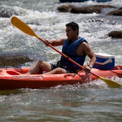
This park is awesome. (Go Team Albino Cows!) I went on a group "camping" trip with about 8 friends. We arrived around 10pm to our cabin (which was rustic and beautiful). It was pitch dark. You could see thousands of stars. Beautiful!! But, there were ominous white cows with red eyes staring at us. Scary!! We instantly made friends with our neighbors who taught us how to 2 step. That night we sat up sharing stories and having fun. Saturday, we woke up and went on a 4 mile hike. The trail was fairly easy and the views were great. We hiked to an old power station with only the brick wall remaining. We finished up our hike then rented canoes and paddled to a beautiful waterfall. This park has so much to do. They have several campsites and a cabin available for rent. There's a covered bridge (one of only 20 in the state), horse stalls, bicycling, canoeing, paddle boats rentals, and fishing.


16 days ago


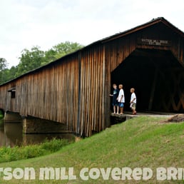
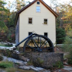
On this rainy and chilly Sunday morning the park felt almost suspended in its own quiet, the kind of stillness you only get when the weather keeps everyone else home and you end up with the place to yourself. No one was camping or fishing or wandering the grounds (though I did see one park ranger pickup truck on patrol), which meant I had time with the real centerpiece of the park, the Watson Mill Covered Bridge, and the soft sound of the river underneath it carried farther than usual in the damp air. The bridge was built in 1885 by W. W. King, one of Georgia's most skilled nineteenth century bridge builders, and it remains the longest existing covered bridge in the state at 236 feet. It uses the Town lattice truss system, a design patented in 1820 that relies on a crisscross pattern of planks secured with wooden pegs, and Watson Mill is one of the best surviving examples of that method in the Southeast. The bridge once served the workers of the grist mill and sawmill that stood nearby, and it doubled as a community gathering place where people held picnics and even square dances. The Georgia Department of Transportation restored it in 1973, and the bridge became the anchor for the surrounding state park, which preserves both the structure and the landscape that supported it. The posted clearance was too low for my Sprinter van so I walked the length of the bridge instead, letting the boards creak underfoot and taking in the smell of wet timber that always feels older than the structure itself. There is no dedicated pedestrian lane, but the interior is wide enough that I could step to the side when a car approached, and the drivers moved slowly enough that it never felt unsafe. The combination of the rain, the quiet, and the long wooden tunnel made the whole experience feel like stepping back into the late nineteenth century for a few minutes. [Review 245 of 2026 - 942 in Georgia - 25434 overall] read more


1 year ago
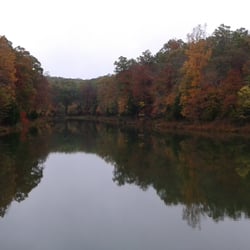
Beautiful, just beautiful place to go hike walk enjoy peace and quiet family time or whatever you want. Lovely, beautiful place small country perfect setting. read more


1 year ago
3 years ago
Peaceful! Nice nature walk to take with kids, plenty of little photo ops next to the water! The playground was a nice little break for mom while kids got the rest of their energy out! read more

9 years ago
This is a very beautiful spot to visit. We rented one of the log cabins at the equestrian campground. The cabin is really well built and has a lovely rustic charm. A little bit dirty but nothing that couldn't be overcome with a broom and the flip of a mattress. It has heat for the colder months and AC for summer. Important to note: 1.) If you arrive after 5:00 pm you retrieve a key from a lockbox. There is a number to phone. No one answered but the campground host was able to help. 2.) Bring a lantern and/or a flashlight. The campground is very dark (great for sleeping.) 3.) There is only one flush toilet and one semi outdoor shower stall for all campers to share. Each time we used the restroom we had to wait in line. Some folks might be cool with that as it is camping but for me personally that would be the one negative. All in all a very pretty place with a nice historic atmosphere. read more


14 years ago
I caught wind of this place from reading the Atlanta Yelp threads and decided that it would be a great adventure for our Memorial Monday afternoon. We packed up the kids and all our beach/picnic gear and headed to see this landmark and play in it's waters. However, it was not at all what we were expecting. The standing water had a oily haze across it's surface, mosquito larva was in one section and huge schools of tadpoles in another. There was an odor in the air of stagnant water and/or something dead or dying. In the small whirlpools there was this brown gewy foam building up. We also spotted a dead fish in one algae filled pool of water. So needless to say we decided to forgo our plans to get wet and just admired the landmark instead. SUMMARY: It's kind of a dumping ground, as people have left behind shoes, flip flops, cans, tents and towels. Too bad, but it was still a great opportunity to visit local history. In the end, we spent a half hour taking a few pics and heading back to our car. The bridge itself is very cool and worth a visit if you are into landmarks like these. Georgia once had over 200 covered bridges, but only 16 now remain. We'll use this visit as a fun opportunity to begin a new quest with our children to find all the remaining covered bridges in Georgia. I loved seeing the old wooden nails used in the original construction. Overall, it was a pretty solid structure and not as rickety as it looks. The water flow was pretty low, which may be the major reason for the stagnant water pools. Probably better to visit after heavy rainfalls. We drove to Fort Yargo Beach instead for the kids to have a little cleaner water fun, which they greatly appreciated since their mom practically bathed them in antibacterial gel after splashing some water from the river on themselves. LOL read more


19 years ago
This park is awesome. (Go Team Albino Cows!) I went on a group "camping" trip with about 8 friends. We arrived around 10pm to our cabin (which was rustic and beautiful). It was pitch dark. You could see thousands of stars. Beautiful!! But, there were ominous white cows with red eyes staring at us. Scary!! We instantly made friends with our neighbors who taught us how to 2 step. That night we sat up sharing stories and having fun. Saturday, we woke up and went on a 4 mile hike. The trail was fairly easy and the views were great. We hiked to an old power station with only the brick wall remaining. We finished up our hike then rented canoes and paddled to a beautiful waterfall. This park has so much to do. They have several campsites and a cabin available for rent. There's a covered bridge (one of only 20 in the state), horse stalls, bicycling, canoeing, paddle boats rentals, and fishing. read more

5 years ago
6 years ago
9 years ago
Just a little pit stop off the trip we were on. Great little covered bridge. THe Park looks amazing. Construction next to the bridge with tractors. read more


7 years ago
I had a great time visiting this park for the first time. I love finding new places and this is one to come back again! My boyfriend and I took our little pup with us. She loved the water and hike. I took beautiful pictures! read more

9 years ago
11 years ago
15 years ago
More info about Watson Mill Bridge State Park
650 Watson Mill Rd
Comer, GA 30629
Directions
(706) 783-5349
Call Now
Hours
Outdoor Amenities
Ask the Community - Watson Mill Bridge State Park
Review Highlights - Watson Mill Bridge State Park


Why does Yelp recommend reviews?
1 review that is not currently recommended
The reviews below are not factored into the business's overall star rating.
17 years ago
Watson Mill Bridge State Park - parks - Updated June 2026
Best of Comer
People found Watson Mill Bridge State Park by searching for…
Hiking Trails With Waterfalls in Comer, Georgia
Things to Do in Comer, Georgia
Places to Take Pictures in Comer, Georgia
Fishing Spots in Comer, Georgia
Scenic Drive in Comer, Georgia
Secret Spots in Comer, Georgia
River Swimming in Comer, Georgia
Tent Camping in Comer, Georgia
Picnic Areas in Comer, Georgia
Secluded Spots in Comer, Georgia
Camping Sites in Comer, Georgia
Walking Trails in Comer, Georgia
Parks for Picnics in Comer, Georgia
Lakes & Ponds in Comer, Georgia
Trending Searches in Comer, GA
Baseball Fields near Watson Mill Bridge State Park
Black Owned Nail Salons near Watson Mill Bridge State Park
Cliff Jumping near Watson Mill Bridge State Park
Day Trips near Watson Mill Bridge State Park
Fishing Spots near Watson Mill Bridge State Park
Kayak Rental near Watson Mill Bridge State Park
Lakes near Watson Mill Bridge State Park
Lakes & Ponds near Watson Mill Bridge State Park
Off Road Trails near Watson Mill Bridge State Park
Outdoor Activities near Watson Mill Bridge State Park
Paddle Boat Rentals near Watson Mill Bridge State Park
Peach Picking near Watson Mill Bridge State Park
Public Pools near Watson Mill Bridge State Park
Public Shower near Watson Mill Bridge State Park
River Swimming near Watson Mill Bridge State Park
River Tubing near Watson Mill Bridge State Park
Rock Quarry near Watson Mill Bridge State Park
Scenic Night View near Watson Mill Bridge State Park
Scenic Overlook near Watson Mill Bridge State Park
Secluded Spots near Watson Mill Bridge State Park
Soccer Store near Watson Mill Bridge State Park
Splash Pad near Watson Mill Bridge State Park
Strawberry Picking near Watson Mill Bridge State Park
Swimming Holes near Watson Mill Bridge State Park
Swimming Lakes near Watson Mill Bridge State Park
Watch Sunset near Watson Mill Bridge State Park
Browse Articles
Browse Nearby
Browse Brands
Related Searches in Comer, GA
Best Fishing Locations and Guides in Comer, Georgia
Best Nature Trails for Hiking in Comer, Georgia
Best Off Leash Dog Parks in Comer, Georgia
Best Parks for Parties and Events in Comer, Georgia
Best Places for Horseback Riding in Comer, Georgia
Best Water Parks for Kids in Comer, Georgia
Best Waterfalls and Swimming Holes in Comer, Georgia
Check Out Great Playgrounds in Comer, Georgia
Check Out Off Road Trails in Comer, Georgia
Discover Baseball Fields Around Comer, Georgia
Discover Dog Friendly Trails to Explore in Comer, Georgia
Discover Fun Toddler Parks in Comer, Georgia for Your Little One
Discover Lakes & Ponds to Explore in Comer, Georgia
Discover Popular Bike Trails in Comer, Georgia
Discover Popular Photo Spots in Comer, Georgia
Discover Scenic Mountain Bike Trails Near Comer, Georgia
Discover Soccer Fields in Comer, Georgia Near You
Discover a Hiking Trail in Comer, Georgia
Discover the Best Night Hike Trails in Comer, Georgia
Discover the Best Running Track in Comer, Georgia
Dog-Friendly Hikes With Dogs in Comer, Georgia
Effective Stairs Workout Spots in Comer, Georgia
Enjoy Scenic Night View Experiences in Comer, Georgia
Enjoy the Best Picnic Spots and Ideas in Comer, Georgia
Enjoy the Best Walking Trails in Comer, Georgia
Explore Beautiful Parks and Green Spaces in Comer, Georgia
Explore Easy Hikes Perfect for All in Comer, Georgia
Explore Free Picnic Areas Around Comer, Georgia
Explore Off Leash Dog Beaches in Comer, Georgia
Explore Parks With Pull Up Bars in Comer, Georgia
Explore Popular Campgrounds Near Comer, Georgia
Explore Popular Picnic Areas Around Comer, Georgia
Explore Popular Scenic Overlook Points in Comer, Georgia
Explore Popular Scenic Views Near Comer, Georgia
Explore Popular View Points Around Comer, Georgia
Explore Scenic Lakes to Visit in Comer, Georgia
Explore Secret Spots Worth Visiting in Comer, Georgia
Explore Top Gyms in Comer, Georgia Now
Explore the Best Swimming Holes Around Comer, Georgia
Explore the Best Trail Options in Comer, Georgia
Family Friendly Hiking With Kids in Comer, Georgia
Find Beautiful Views in Comer, Georgia
Find Fun Kids Activities Outdoor in Comer, Georgia
Find Fun Things to Do With Kids in Comer, Georgia
Find Parks and Recreation Activities in Comer, Georgia
Find Picnic Tables for Outdoor Fun in Comer, Georgia
Find Top Dog Friendly Parks to Visit in Comer, Georgia
Find Top-Rated Waterfalls in Comer, Georgia Now