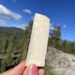
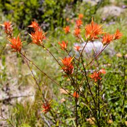
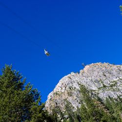
Thunder Mountain Hike Photos


You might also consider
More like Thunder Mountain Hike
Recommended Reviews - Thunder Mountain Hike
Start your review...

3 years ago
This is not an easy hike. Expect a nice workout! It starts out steep with lots of slippery gravel so we think it's much better to go up than down. Once you get past the first part, you are rewarded with beautiful views - especially now with the fall colors! We even saw some cool fuzzy caterpillars this time! They need to refresh the blue paint markers that show the way on the path - they are fading so much in some places you can miss them. I relied heavily on my AllTrails navigation map. There are some more tricky, steep areas as you get near the top. One reason I enjoy this hike is because of the sense of accomplishment you feel when you finally find your way to the top. There is an 1833 ft elevation gain - even more if you climb the stairs to get to the aerial tram at High Camp. We like to do this because if you climb up, you can take the tram back down to the Village in Palisades for free (hint: the tram is now closed through the end of November 2023 for repairs). While up there, we also like to look around at the artifacts in the 1960 Winter Olympics Museum. Taking the tram down is always nice. Lots of spectacular views. read more


10 years ago
I was disappointed since half of the trail was close , about half of the way we finally got to go on the trail and the views got beautiful , if I try it again maybe it will be better to do it end of spring or early summer. read more

More info about Thunder Mountain Hike
237 Granite Chief Rd
Tahoe City, CA 96145
Directions
Hours
Outdoor Amenities
You might also consider


Thunder Mountain Hike - hiking - Updated May 2026
Best of Tahoe City
People found Thunder Mountain Hike by searching for…
Hiking Trails in Tahoe City, CA
Walking Trails in Tahoe City, CA
Fun Things to Do in Tahoe City, CA
Stairs Workout in Tahoe City, CA
Stair Climbing in Tahoe City, CA
Scenic Overlook in Tahoe City, CA
Running Trails in Tahoe City, CA
Beautiful Views in Tahoe City, CA
Off Leash Dog Hikes in Tahoe City, CA
Tent Camping in Tahoe City, CA
Off Road Trails in Tahoe City, CA
Lookout Points in Tahoe City, CA
Running Routes in Tahoe City, CA
Places to Go in Tahoe City, CA
Trending Searches in Tahoe City, CA
Boat Rental near Thunder Mountain Hike
Botanical Gardens near Thunder Mountain Hike
Bounce House Rentals near Thunder Mountain Hike
Campgrounds near Thunder Mountain Hike
Cherry Picking near Thunder Mountain Hike
Cliff Jumping near Thunder Mountain Hike
Dog Friendly Things To Do near Thunder Mountain Hike
Flower Fields near Thunder Mountain Hike
Flower Shop near Thunder Mountain Hike
Garage Sales near Thunder Mountain Hike
Hair near Thunder Mountain Hike
Lakes & Ponds near Thunder Mountain Hike
Nurseries & Gardening near Thunder Mountain Hike
Outdoor Activities near Thunder Mountain Hike
Outdoor Furniture Stores near Thunder Mountain Hike
Parks near Thunder Mountain Hike
Party Equipment Rentals near Thunder Mountain Hike
Pedicure near Thunder Mountain Hike
Pick Your Own Farms near Thunder Mountain Hike
Picnic Areas near Thunder Mountain Hike
Places To Take Pictures near Thunder Mountain Hike
Running Trails near Thunder Mountain Hike
Scenic Drive near Thunder Mountain Hike
Secret Spots near Thunder Mountain Hike
Strawberry Picking near Thunder Mountain Hike
Sunrise View near Thunder Mountain Hike
Swimming Holes near Thunder Mountain Hike
Table And Chair Rentals near Thunder Mountain Hike
Browse Articles
Browse Nearby
BEST of Tahoe City, California Coffee near Thunder Mountain Hike
BEST of Tahoe City, California Restaurants near Thunder Mountain Hike
BEST of Tahoe City, California Things to Do near Thunder Mountain Hike
BEST of Tahoe City, California Breakfast near Thunder Mountain Hike
BEST of Tahoe City, California Walking Trails near Thunder Mountain Hike
BEST of Tahoe City, California Parks near Thunder Mountain Hike
BEST of Tahoe City, California Hotels near Thunder Mountain Hike
BEST of Tahoe City, California Sledding near Thunder Mountain Hike
BEST of Tahoe City, California Snow Tubing near Thunder Mountain Hike
Browse Brands
Related Searches in Tahoe City, CA
Affordable Kayak Rental Services in Tahoe City, California
Best Fishing Locations and Guides in Tahoe City, California
Best Places for Horseback Riding in Tahoe City, California
Best Sledding Spots and Fun in Tahoe City, California
Best Waterfalls and Swimming Holes in Tahoe City, California
Check Out Off Road Trails in Tahoe City, California
Discover Dog Friendly Trails to Explore in Tahoe City, California
Discover Kid Friendly Hiking Trails in Tahoe City, California
Discover Scenic Mountain Bike Trails Near Tahoe City, California
Discover Scenic Waterfall Spots in Tahoe City, California
Discover a Hiking Trail in Tahoe City, California
Discover the Best Night Hike Trails in Tahoe City, California
Dog-Friendly Hikes With Dogs in Tahoe City, California
Enjoy Camping Adventures Around Tahoe City, California
Enjoy Exciting Mountain Biking Adventures in Tahoe City, California
Enjoy Kayaking Adventures in Tahoe City, California
Enjoy Tent Camping Spots Around Tahoe City, California
Enjoy a Beautiful Waterfall Hike in Tahoe City, California
Enjoy the Best Picnic Spots and Ideas in Tahoe City, California
Enjoy the Best Tubing Experiences in Tahoe City, California
Enjoy the Best Walking Path in Tahoe City, California
Enjoy the Best Walking Trails in Tahoe City, California
Experience Thrilling White Water Rafting in Tahoe City, California
Explore Beautiful Parks and Green Spaces in Tahoe City, California
Explore Easy Hikes Perfect for All in Tahoe City, California
Explore Fun Activities to Do in Tahoe City, California
Explore Popular Campgrounds Near Tahoe City, California
Explore the Best Beach Spots in Tahoe City, California
Explore the Best Boating Spots in Tahoe City, California
Explore the Best Swimming Holes Around Tahoe City, California
Explore the Best Trail Options in Tahoe City, California
Family Friendly Hiking With Kids in Tahoe City, California
Find Beautiful Views in Tahoe City, California
Find Popular Ziplining Spots Around Tahoe City, California
Find the Best Scenic View Locations in Tahoe City, California
Hike the Popular Waterfall Trail in Tahoe City, California
Hiking Trails With Waterfalls in Tahoe City, California
Off Leash Dog Hiking Trails in Tahoe City, California
Plan a Scenic Drive Route Near Tahoe City, California
Popular Outdoor Activities to Try in Tahoe City, California
Popular Picnic Spots to Visit in Tahoe City, California
Safe River Swimming Areas in Tahoe City, California
Safe and Fun Parks for Kids in Tahoe City, California
Top Climbing Spots and Gyms in Tahoe City, California
Top Running Trails to Explore in Tahoe City, California
Top Swimming Lakes to Enjoy in Tahoe City, California
Top Swimming Spots and Pools in Tahoe City, California
Top Things to Do With Kids in Tahoe City, California
Walk Dog Friendly Hiking Trails in Tahoe City, California
Walk the Best Paved Walking Trails in Tahoe City, California