Cancel

    Open app

    Search

    Thornton Hollow Trail

    3.0 (1 review)

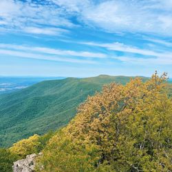
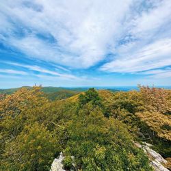
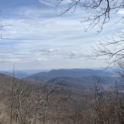
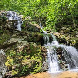
    Thornton Hollow Trail Photos

    You might also consider

    More like Thornton Hollow Trail

    Recommended Reviews - Thornton Hollow Trail

    Your trust is our priority, so businesses can't pay to alter or remove their reviews. Learn more about reviews.
    Yelp app icon
    Browse more easily on the app
    Review Feed Illustration

    15 years ago

    Helpful 6
    Thanks 0
    Love this 3
    Oh no 0

    Verify this business for free

    People searched for Hiking 268 times last month within 15 miles of this business.

    Verify this business

    Corbin Cabin - Nicholson Hollow Trail

    Corbin Cabin - Nicholson Hollow Trail

    5.0(2 reviews)
    0.0 mi

    The Corbin Cabin - Nicholson Hollow Trail is a wonderful way to enjoy the beautiful fall foliage!…read more This hike shares a parking lot with Old Rag Mountain, but happily, doesn't share the crowds. When my friend and I arrived on a Sunday morning, we were informed by a ranger that the parking lot was completely full, but that the enterprising little old lady next door was selling parking spots in her pasture for a whopping $10. Sucker that I am, I paid up. After a 2 hour drive, I was not about to miss out on a gorgeous autumn hike! We were not disappointed. Although this hike doesn't offer much in the way of vistas, it's a terrific way to spend a day in the woods. Reports online seem to vary, but my friend's GPS device recorded this hike (from the parking lot and back again) as a 14 mile trip. This hike was a blast! It's long, with a strenuous ascent and lots of rock-hopping creek crossings. Seeing the crowds on the way to Old Rag, we were nervous that this trail would be packed, but we only passed a few other hikers. Quite a lot of this hike runs alongside a river, so it's very pretty and peaceful. When we picked up a trail map at the station, the ranger suggested that we hike this loop clockwise. He was right on! This gave us a nice, challenging start, with a relaxing conclusion walking next to the river - perfect!

    Went to cabin for four days, three nights in December 2018 with friend who booked it. Hiked down…read morefrom Skyline Drive and due to lots of rain had to ford the Hughes River. Was wisely warned to bring sneakers and rope. Amazing little, well-equipped cabin with outside privy very deep in the woods. Used main room for almost all activities since easier to keep only one room warm with fireplace vs. two with stove in kitchen. Area is very nice and cabin allows a base camp for hikes throughout the nearby trails and hills. Highly recommend this spot, even if you have to walk through the brisk river to get there. Warnings include bears and venomous snakes (possibly in cabin) but saw neither in December.

    Little Devils Stairs Trail

    Little Devils Stairs Trail

    4.5(2 reviews)
    5.8 mi

    CAUTION: Bring an extra pair of socks or two. There are a lot of streams you need to cross (by…read morehopping over rocks which aren't all stable to the ground) so you could easily just drench your shoes if you're not the most agile like me. If you're looking for a workout hike, then this is for you. Especially on a cloudy winter day, you're mainly looking at dead trees - lots of brown and more tan-ish looking brown scenery, so really not the best views. However, there are mini waterfalls and streams every now and then. The overlook is also small and pretty sad in terms of views. Overall, the hike is pretty hard for people who don't go hiking very often, but it was very satisfying after making it up to the top. There's a lot of rocks you need to hike up (mainly rocky paths and trails) and streams. Make sure you enter through the right side of the parking lot if you're looking for the Little Devils Stairs Trail (there should be a long pole looking sign with the name on it). You will be hiking up about 3 miles (~1500 feet of elevation). Be careful and make sure you are following the blue markers. They weren't very obvious to me, but fortunately, one of my friends have gone on this hike before so he knew where he was going. Afterwards, you can take the fire road down (super easy downhill walk on a trail). The entire hike is about 5.5-6 miles - it was tough going up, but an easy and relaxing walk to the bottom. Note, if you want to go to the overlook, it's on the way down on the fire road, not on the top. It's pretty small so it can be easy to miss.

    My husband and I hiked this trail and found it to be pretty strenuous for us, personally. We are…read moreaverage middle age folks that love the outdoors. We went up the trail side and came down the fire road, as most people we saw. Our tech devices measured 7.4 miles total which is more than we anticipated. An unexpected burial site and a small overlook on the fire road. Some scrambling necessary. Pretty steep and I'm glad we chose to go up the trail and down the fire road rather than the opposite. We would have struggled coming down! Really beautiful hike with lots of water crossovers. Will go again!

    Photos
    Little Devils Stairs Trail

    See all

    Hollow Brook Trail - Huge parking area. Thank you!

    Hollow Brook Trail

    4.5(12 reviews)
    33.2 mi

    A great day for a hike on the A.T. This one is just o/s Fauquier County on Mt Weather. I took the…read moreSOBO trail a couple years ago. This time I went North to the waterfall. Let me give some mad respect to whomever dug out the spot to put in a rather large parking area for us! For years we've been on side of this narrow dirt road. * Thank. (Virtual fist pump). This was 3 miles out and 3 miles back. The waterfall is around 1 mile mark. It's off to the right. *please understand, ricks are slippery whether they're wet ot not. How someone brings three toddlers here with no backpack, water or first aid is beyond me. I had to leave the area. But it was really nice. Very relaxing and you did have to hand/foot climb to get up there. Be careful please. I double backed and got on the A.T. Couple more miles to the secret cliff I saw in another Yelp post. :) . Lots of people walked by, no one knew I was there. I had it all to myself. Its better than the actual lookout. Anyway. I scanned the rocks for danger, shot some pics and sat down for water and dry crackers. I look over and there are 2 snakes curled up by a small tree about 6 feet from me. I spoke to them. "Thought you'd hide from me. I got you!" It was funny. I took a couple pics and kept my eyes on them. Only takes a second to lose track and they end up right at me saying, "HA got you back!" I sat a while then headed back down. I enjoyed it! I'd like to section hike and have a car waiting to take me back to my own car where I started. They should have an Uber Hikes App available for that. ;) This way I can hike for as far as I want without turning around to come straight back.

    Short trail, pretty and cool, but the waterfall wasn't what I expected. The trail was well kept,…read moreand trimmed back, some areas were steep, and can be slick if it rains.

    Photos
    Hollow Brook Trail - Here's the waterfall pic, that really does it no justice. In person, its perfectly pleasing.

    Here's the waterfall pic, that really does it no justice. In person, its perfectly pleasing.

    Hollow Brook Trail - Hello.

    Hello.

    Hollow Brook Trail - Then, the rocks.. I had my toe bandaged. :)

    See all

    Then, the rocks.. I had my toe bandaged. :)

    Old Rag Mountain

    Old Rag Mountain

    4.8(137 reviews)
    12.5 mi

    My favorite hike in Virginia!…read more I love the rock scrambling that this hike has. The view at the top is worth the hike! There are many spots with great views of the mountains around. Because it is a longer hike and the rock scrambling it makes it a harder hike than many others in Virginia. It's a hike you won't forget! Make sure to bring lots of water and snacks.

    I've been wanting to tackle the Old Rag hike for quite some time. My friends from Outdoor Afro…read moreorganized a group hike. I couldn't resist! We began our hike at 0930. I've gotta say, I was surprised at our starting location. I didn't have to drive through the 'booth' and pay to actually enter the park. That was weird to me, but our hike leader explained that, during the busy season, rangers are on site to check for passes. So.... I assume you'd have to purchase a pass online and place it on your dashboard. I'm a Veteran so I have that pass so I couldn't tell you how that works. Right off the bat you're climbing. No easing into your hike, you're THERE, at elevation. Of course, the higher you climb the mountain the more elevation you gain, but at the start you're already gaining. There are a lot of false summits. You think you've made it to the top, but you're not there yet! Ha! Because it was January, the trees were barren, so I could see the vastness of the forest. There was a bit of ice, but nothing that impeded our climb. I had always planned to do the hike in fall, to see the colors, but this was great as well. It was a perfect day. And then there's the rock scramble-----AMAZING! I loved climbing over, under, and through the rocks. There are times you have to jump over a small gap or squeeze between rocks, but I was down for it all! I was on the trip with people who had done the hike before so that helped in a few situations where I could have gotten lost or didn't quite know how to get over a rock. Once we finally made it to the actual peak, the view was amazing! The entire hike was awesome! Some of the rock placements, like, how does a rock just sit in a certain spot, have you wondering HOW. It's that 'Awe' factor. We had some slower hikers and we didn't want to leave anybody behind. So, that brought us to the point where we were coming down in the dark. Luckily, I had my head lamp and so did many others. A quick note to be prepared for anything. Those worst case scenarios are possible. It's a GREAT hike and I'll definitely do it again with ONLY seasoned hikers.

    Photos
    Old Rag Mountain - The views are awesome!

    The views are awesome!

    Old Rag Mountain
    Old Rag Mountain

    See all

    Dark Hollow Falls Trail

    Dark Hollow Falls Trail

    4.7(21 reviews)
    14.6 mi

    We did this hike at the end of October. It was cloudy and drizzling that day but I still enjoyed…read morethis hike throughly. The autumn color was perfect. I would rate this hike as easy. The trail went downhill in the beginning but on the way back the incline was gradual through out the hike. One of my friends who did this hike with me was pregnant and was able to do this hike with breaks intermittently. Parking lot could get busy. I saw some people parked on the grass, just be careful not to get stuck in the mud if it's raining.

    We were pumped to try this easy trail but quickly found out it's more moderate than easy. My…read morehusband has a broken vertebrae in his back so he had to turn around. I decided to push forward and was so happy I did. Such a breathtaking hike. The falls are gorgeous and the path is very nice. They have steps built in to many steep places that makes it very easy to navigate. It was a very warm spring day and I did not bring enough water. Bring water or at least a filter so you can have as much drinking water as you need. I enjoyed the hike down but was quickly humbled on the way back up! When I say breathtaking I mean I was out of breath and breathing hard on the way up. So worth it though. I actually hiked down to the Rose River Loop Trail and that's where I turned around to go back up and it's like a 945 ft elevation gain in 1.5 miles. I had to take some breaks and even cooled myself down a bit in the water. What an epic hike though and I even saw a deer!

    Photos
    Dark Hollow Falls Trail - Instagram: @telephonesmoothie

    Instagram: @telephonesmoothie

    Dark Hollow Falls Trail
    Dark Hollow Falls Trail

    See all

    Doyles River Falls Trail

    Doyles River Falls Trail

    4.7(3 reviews)
    17.5 mi

    After staying overnight at the Big Meadows Lodge, we stopped in a second time at the Harry F. Byrd…read moreSr. Visitor Center to get a few more recommendations from the Park Rangers on a hike we could do that day before making the long drive back home to Georgia. Among her recommendations, we chose Doyles River Falls Hike because it was south of where we were, which is the direction we needed to go back home. The real incentive was the two waterfalls on the trail. Having lived in Hawaii for 3 years and hiking on a weekly, if not, on a daily basis, I really missed the mountains and especially the waterfalls hikes! Might as well get all the waterfalls in while we can, because the only waterfall I have found in Savannah is at Big Bass Pro Shop LOL. If you know of any others in Savannah, please do tell! - Trail Description - Doyles River Falls Hike is found on Mile Marker 81.1, just after the Loft Mountain Wayside & Camp Store. Distance - 3.3 miles RT Elevation Gain - 1189 ft Level - Moderate, downhill first, uphill on the way back, so keep that in mind. Multiple stream crossings (none that we got our feet wet in). It's a well maintained trail, mostly shaded, but beware of the sharp loose rocks throughout the trail. We went on a day after it rained and some parts were pretty slippery. There is a spring that you come across at the beginning, but make sure to boil it if you are going to consume it. There are two waterfalls on this trail (approx. 20 ft and 60 ft) and also a bonus waterfall. You will arrive at the bonus waterfall first and you might think that it is the Upper Falls, but the Upper Falls is actually the next one as you continue and the Lower is after the Upper Falls. The bonus falls is probably about 10 ft high and you can easily step into the pool of water that it falls into. Just be sure to read the etched markings on the cement posts to guide you. The Upper Falls (28 ft) has 2 tiers of falls, with large boulders to get to it from the path. The Lower Falls (63 ft) has about 3 tiers of falls. It's pretty tricky to get down to this one. Most climbed down the pretty steep way which I would suggest climbing down with extreme caution. We have small kids, so we decided to go down a little further (not much further) on the trail and then climb down (it was still pretty steep), and then crossed over on the water to get to a small patch of pebbly rocks to look at the waterfall (on the right side, if you're looking at the waterfall). There was a huge tree that fell over about three quarters of the way up the waterfall and it was difficult to get a whole shot, but what can you do about Mother Nature? She does what she wants! It's all part of the charm. - Kiddos - Our kids are still young, but they did it no problem. However, just a note, they lived in Hawaii most of their lives and started hiking at an early age. and did some pretty advanced trails on their own by the time we left Hawaii. Some of the parts of this trail has steep drop offs. On the way there, you're going downhill, so just watch your kids that they don't pick up speed and lose control. Bonus - The Appalachian Trail (AT) crosses over at the trailhead of Doyles River Falls Hike, so at least you can put your two feet on it and say you were on it! I will be back for you AT! I'm sure you can't go wrong with any of the hikes in Shenandoah National Park and I wish we had had more time or even lived close by, but we did two waterfall hikes during our time in Shenandoah and my heart is full, at least for a little while, to have seen another beautiful waterfall!

    So pretty a hike! Creek crossings are beautiful and a great spot to cool down. The falls, upper and…read morelower, and great photo spots as well. You will need to remember as you hike downhill all the way in that the hike out is going to be rough, and uphill all the way. There is a great vine to swing on about 1/3 of the way down.

    Photos
    Doyles River Falls Trail - Water drops

    Water drops

    Doyles River Falls Trail - Flower found on this trail

    Flower found on this trail

    Doyles River Falls Trail - Exceptional parking

    See all

    Exceptional parking

    Thornton Hollow Trail - hiking - Updated May 2026

    Loading...
    Loading...
    Loading...