Lewis Falls Photos


You might also consider
More like Lewis Falls
Recommended Reviews - Lewis Falls
Start your review...

3 years ago
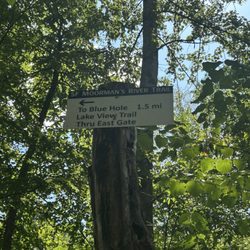
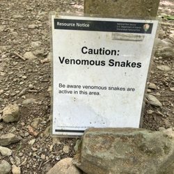
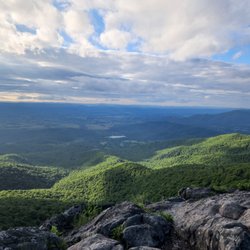
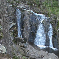
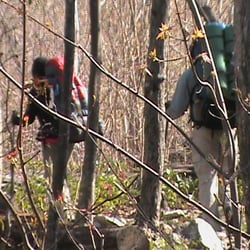
Lewis Falls can be found inside the Big Meadow Campground as well as access by roadside at MM 51.2 - This is the Central Zone for SNP, by the way. I started the trailhead by the amphitheater inside the Big Meadow Campground, and I'm glad I did. This leg is really rocky and it had just rained when I was there so the rocks are then slippery as well. Better hiking down to the falls this way, I thought. I saw lots of cute critters along the way. The forest trail was beautiful. Great views!!! After about a couple miles you hear some rushing water. Go down a side path and there it is, an 81ft waterfall. After all the rain, it was gorgeous. Big green mountains in the backdrop. To finish the round trip, you'll take a fire road up to the Skyline Drive Road, so it's no big rocky path. It wasn't too strenuous at all. A great 7 mile hike as a round trip. About 3 miles if you park roadside and use the fire road to go down and back up. (Approximately). It's worth it. read more


More info about Lewis Falls
Skyline Dr
Big Meadows Campground
Elkton, VA 22827
Directions
Hours
Outdoor Amenities


Lewis Falls - hiking - Updated July 2026
Best of Elkton
People found Lewis Falls by searching for…
Hiking Trails With Waterfalls in Elkton, Virginia
Campgrounds in Elkton, Virginia
Things to Do in Elkton, Virginia
Scenic View in Elkton, Virginia
Scenic Overlook in Elkton, Virginia
Waterfalls and Swimming Holes in Elkton, Virginia
View Points in Elkton, Virginia
Waterfalls in Elkton, Virginia
Beautiful Views in Elkton, Virginia
Walking Trails in Elkton, Virginia
Easy Hiking Trails in Elkton, Virginia
Camping Sites in Elkton, Virginia
Running Trails in Elkton, Virginia
Off Road Trails in Elkton, Virginia
Scenic Spots in Elkton, Virginia
Lookout Points in Elkton, Virginia
Tent Camping in Elkton, Virginia
Off Leash Dog Hikes in Elkton, Virginia
Camping Cabins in Elkton, Virginia
Stroller Friendly Hikes in Elkton, Virginia
Bike Paths in Elkton, Virginia
Trending Searches in Elkton, VA
Black Owned Nail Salons near Lewis Falls
Cliff Jumping near Lewis Falls
Jet Ski Rental near Lewis Falls
Lakes & Ponds near Lewis Falls
Off Road Trails near Lewis Falls
Outdoor Activities near Lewis Falls
Parks For Picnics near Lewis Falls
Public Shower near Lewis Falls
River Swimming near Lewis Falls
Scenic Night View near Lewis Falls
Scenic Overlook near Lewis Falls
Secluded Spots near Lewis Falls
Strawberry Picking near Lewis Falls
Swimming Holes near Lewis Falls
Browse Articles
Browse Nearby
Browse Brands
Related Searches in Elkton, VA
Affordable Kayak Rental Services in Elkton, Virginia
Best Fishing Locations and Guides in Elkton, Virginia
Best Places for Horseback Riding in Elkton, Virginia
Check Out Off Road Trails in Elkton, Virginia
Discover Dog Friendly Trails to Explore in Elkton, Virginia
Discover Scenic Mountain Bike Trails Near Elkton, Virginia
Discover Walking Parks in Elkton, Virginia Near You
Discover a Hiking Trail in Elkton, Virginia
Discover the Best Night Hike Trails in Elkton, Virginia
Dog-Friendly Hikes With Dogs in Elkton, Virginia
Enjoy River Tubing Adventures in Elkton, Virginia
Enjoy Tent Camping Spots Around Elkton, Virginia
Enjoy a Beautiful Waterfall Hike in Elkton, Virginia
Enjoy the Best Picnic Spots and Ideas in Elkton, Virginia
Enjoy the Best Tubing Experiences in Elkton, Virginia
Enjoy the Best Walking Trails in Elkton, Virginia
Explore Beautiful Parks and Green Spaces in Elkton, Virginia
Explore Easy Hikes Perfect for All in Elkton, Virginia
Explore Fun Activities to Do in Elkton, Virginia
Explore Popular Campgrounds Near Elkton, Virginia
Explore Popular RV Parks Around Elkton, Virginia
Explore Popular Scenic Overlook Points in Elkton, Virginia
Explore Popular View Points Around Elkton, Virginia
Explore Scenic Lakes to Visit in Elkton, Virginia
Explore Secret Spots Worth Visiting in Elkton, Virginia
Explore Top Dog Parks in Elkton, Virginia Near You
Explore the Best Boating Spots in Elkton, Virginia
Explore the Best Swimming Holes Around Elkton, Virginia
Family Friendly Hiking With Kids in Elkton, Virginia
Find Beautiful Views in Elkton, Virginia
Find Popular Ziplining Spots Around Elkton, Virginia
Find the Best Parks for Picnics in Elkton, Virginia
Find the Best Playgrounds to Visit in Elkton, Virginia
Hiking Trails With Waterfalls in Elkton, Virginia
Off Leash Dog Hiking Trails in Elkton, Virginia
Perfect Spots to Watch Sunset in Elkton, Virginia
Plan a Scenic Drive Route Near Elkton, Virginia
Popular Fishing Spots to Explore in Elkton, Virginia
Popular Kids Activities in Elkton, Virginia
Popular Outdoor Activities to Try in Elkton, Virginia
Popular Things to Do in Elkton, Virginia
Popular Things to See in Elkton, Virginia
Safe River Swimming Areas in Elkton, Virginia
Top Climbing Spots and Gyms in Elkton, Virginia
Top Paddleboarding Activities in Elkton, Virginia
Top Playgrounds for Kids to Enjoy in Elkton, Virginia
Top Running Trails to Explore in Elkton, Virginia
Top Swimming Lakes to Enjoy in Elkton, Virginia
People who viewed Lewis Falls also viewed
Bearfence Mountain
1 review
Hawksbill Trail
18 reviews
Preddy Creek Trails Park
5 reviews
Marys Rock Tunnel
10 reviews
Loft Mountain Wayside
13 reviews
$$
Elk Run Trails
1 review
Corbin Cabin - Nicholson Hollow Trail
2 reviews
Pinnacles Picnic Ground
2 reviews
Thornton Hollow Trail
1 review
Horizons Edge Sports Campus
4 reviews