Rapidan Camp Area Photos


You might also consider
More like Rapidan Camp Area
Recommended Reviews - Rapidan Camp Area
Start your review...

2 years ago


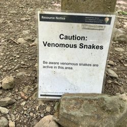
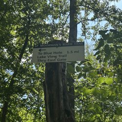
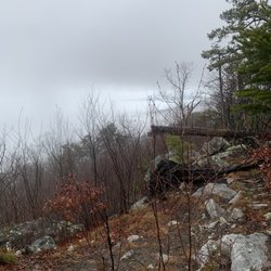
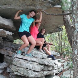
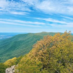
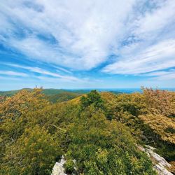
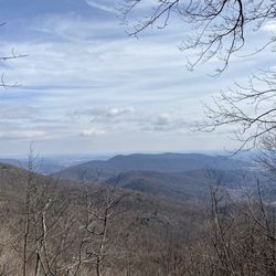
Rapidan Camp loop is a wonderful hike that many people do not know about. You hear Old Rag hike and you hear the White Canyon hike but not the Rapidan Camp loop. You take a Mill Prong trail + Laurel Prong Trail (lot of Laurel flowers at this time of year) and wrap it up with Appalachian trail. The Rapidan Camp, was the summer retreat established by President and Mrs. Herbert Hoover during his administration (1929-1933) and it is still there. This camp precedes Camp David (1938) and you can see it or even rent a cabin! "The site had to be within 100 miles of Washington, at least 2500 feet above sea level to avoid mosquitoes and, above all, near a good trout stream" - The president Hoover said. The best part for me is that you change a lot of scenery and flora on your 7 1/2 mile trip. Bushy, woodsy, rocky, grassy are all the terms you will encounter. Flowers are impossible to miss, the stream gently follows you and the end you have a long walk at the famous Appalachian trail (always white blaze), where you never know who you may meet. The highlight was seeing up close wild grouse, first time in my city slicker life. Picture is here to proof it. The changing scenery of flora made it up for not having the views from a top of the mountain and seeing the vintage presidential retreat cabins makes you feel like you walked in the president boots for a little bit. "Then took the other, as just as fair, And having perhaps the better claim, Because it was grassy and wanted wear; Though as for that the passing there Had worn them really about the same" Robert Frost read more


More info about Rapidan Camp Area


Rapidan Camp Area - hiking - Updated June 2026
Best of Stanley
People found Rapidan Camp Area by searching for…
Hiking Trails With Waterfalls in Stanley, Virginia
Campgrounds in Stanley, Virginia
Things to Do in Stanley, Virginia
Waterfalls and Swimming Holes in Stanley, Virginia
Lookout Points in Stanley, Virginia
Running Trails in Stanley, Virginia
Scenic Overlook in Stanley, Virginia
Waterfalls in Stanley, Virginia
Canyoneering in Stanley, Virginia
Scenic Views in Stanley, Virginia
Walking Trails in Stanley, Virginia
Places to Take Pictures in Stanley, Virginia
View Points in Stanley, Virginia
Off Road Trails in Stanley, Virginia
Tent Camping in Stanley, Virginia
Camping Sites in Stanley, Virginia
Beautiful Views in Stanley, Virginia
River Swimming in Stanley, Virginia
Easy Hikes in Stanley, Virginia
Hiking Trails Kid Friendly in Stanley, Virginia
Trending Searches in Stanley, VA
Boat Rental near Rapidan Camp Area
Cliff Jumping near Rapidan Camp Area
Dog Friendly Trails near Rapidan Camp Area
Fishing Spots near Rapidan Camp Area
Kayak Rental near Rapidan Camp Area
Off Road Trails near Rapidan Camp Area
Outdoor Activities near Rapidan Camp Area
Public Pools near Rapidan Camp Area
River Swimming near Rapidan Camp Area
River Tubing near Rapidan Camp Area
Scenic Overlook near Rapidan Camp Area
Secluded Spots near Rapidan Camp Area
Splash Pad near Rapidan Camp Area
Swimming Holes near Rapidan Camp Area
Swimming Lakes near Rapidan Camp Area
U Pick Farms near Rapidan Camp Area
Browse Articles
Browse Nearby
BEST of Stanley, Virginia Restaurants near Rapidan Camp Area
BEST of Stanley, Virginia Things to Do near Rapidan Camp Area
BEST of Stanley, Virginia Parks near Rapidan Camp Area
BEST of Stanley, Virginia Waterfalls near Rapidan Camp Area
BEST of Stanley, Virginia Coffee near Rapidan Camp Area
BEST of Stanley, Virginia Ski Resorts near Rapidan Camp Area
BEST of Stanley, Virginia Hot Springs near Rapidan Camp Area
BEST of Stanley, Virginia Breakfast near Rapidan Camp Area
BEST of Stanley, Virginia Campgrounds near Rapidan Camp Area
Browse Brands
Related Searches in Stanley, VA
Best Fishing Locations and Guides in Stanley, Virginia
Best Places for Horseback Riding in Stanley, Virginia
Best Spots for Star Gazing in Stanley, Virginia
Check Out Off Road Trails in Stanley, Virginia
Discover Dog Friendly Trails to Explore in Stanley, Virginia
Discover a Hiking Trail in Stanley, Virginia
Discover the Best Night Hike Trails in Stanley, Virginia
Dog-Friendly Hikes With Dogs in Stanley, Virginia
Enjoy Camping Adventures Around Stanley, Virginia
Enjoy Kayaking Adventures in Stanley, Virginia
Enjoy Tent Camping Spots Around Stanley, Virginia
Enjoy a Beautiful Waterfall Hike in Stanley, Virginia
Enjoy the Best Family Activities in Stanley, Virginia
Enjoy the Best Picnic Spots and Ideas in Stanley, Virginia
Enjoy the Best Tubing Experiences in Stanley, Virginia
Enjoy the Best Walking Trails in Stanley, Virginia
Exciting Cliff Jumping Spots in Stanley, Virginia
Experience Stunning Sunset Views in Stanley, Virginia
Explore Beautiful Parks and Green Spaces in Stanley, Virginia
Explore Easy Hikes Perfect for All in Stanley, Virginia
Explore Fun Activities to Do in Stanley, Virginia
Explore Popular Campgrounds Near Stanley, Virginia
Explore Popular Scenic Overlook Points in Stanley, Virginia
Explore Scenic Lakes to Visit in Stanley, Virginia
Explore Top Dog Parks in Stanley, Virginia Near You
Explore the Best Boating Spots in Stanley, Virginia
Explore the Best Swimming Holes Around Stanley, Virginia
Family Friendly Hiking With Kids in Stanley, Virginia
Find Beautiful Views in Stanley, Virginia
Find Cozy Camping Cabins in Stanley, Virginia
Find Top Dog Swimming Spots in Stanley, Virginia
Find the Best Playgrounds to Visit in Stanley, Virginia
Find the Best Scenic View Locations in Stanley, Virginia
Fun Toddler Activities to Try in Stanley, Virginia
Hiking Trails With Waterfalls in Stanley, Virginia
Off Leash Dog Hiking Trails in Stanley, Virginia
Plan a Scenic Drive Route Near Stanley, Virginia
Popular Fishing Spots to Explore in Stanley, Virginia
Popular Outdoor Activities to Try in Stanley, Virginia
Popular Things to Do in Stanley, Virginia
Popular Things to See in Stanley, Virginia
Relax at Natural Hot Springs Near Stanley, Virginia
Safe River Swimming Areas in Stanley, Virginia
Top Climbing Spots and Gyms in Stanley, Virginia
Top Paddleboarding Activities in Stanley, Virginia
Top Playgrounds for Kids to Enjoy in Stanley, Virginia
Top Running Trails to Explore in Stanley, Virginia
Top Swimming Spots and Pools in Stanley, Virginia