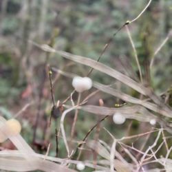
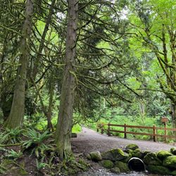
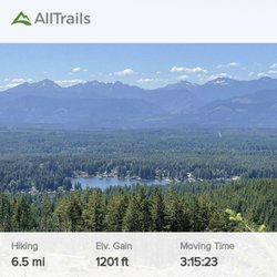
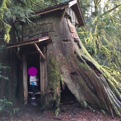
Theler Wetlands Photos


More like Theler Wetlands
Recommended Reviews - Theler Wetlands
Start your review...

Reviews With Photos


5 years ago
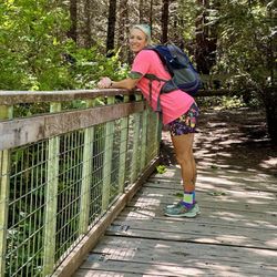
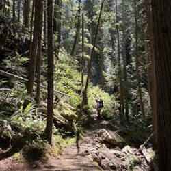
Stumbling upon this place was a pleasant surprise! I saw a sign for nature trails and pulled off and parked the car. I wasn't sure what to expect really, but I was blown away with what I experienced today. I saw very few people out and about on the trails, which made the experience even more enjoyable. The views are breathtaking and what really takes the cake is the ease and accessibility of the trails- really makes for a nice afternoon walk/outing. If I'm ever in the area again, I would certainly like to explore every nook and cranny and possibly see some wildlife! read more


2 years ago
4 years ago
8 years ago
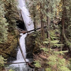
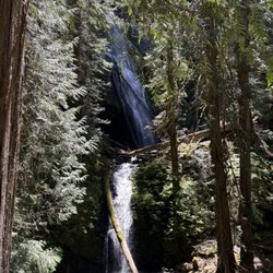
A walk in the forest and along the wetlands is like a dream of another world or time. Choice of a short woodsy walk or an all day wetlands walk, right through the middle of a delta and tidelands to the saltwater canal. Where it's swampiest there'll be raised wooden trails. No elevations so even those of us who're elderly can manage, and mostly accessible to wheelchairs and baby carriages. Theler is one the most beautiful places in Mason County that you can get to easily. Famous for birding. There's a community center with many events; sign up to keep informed. There are exhibits (including a whale skeleton). Their one fault is you can't bring your dog even for a leashed walk, which is to their everlasting shame; not dog friendly is simply wrong to be. But if you hate dogs too, you'll appreciate that little extra feature. It's named for Mary E. Thaler (1901-1950; she died relatively early in an auto accident). She was born right in Belfair and lived most of her life there, as leading citizen, postmistress, general store operator with her husband, scout-mistress and regional promoter of the Girl Scouts, etc. Widower Sam Thaler (1895-1965) attempted to provide for the wetland's preservation in her name into perpetuity. Alas there have been some ongoing threats the intent, as insufficient trust fund, financial troubles, incompetent management, lawsuits, lapsed non-profit status, and evil bankers' attempts to sell parts of the property and its buildings, have all collided with continued preservation. The future of the place seems likely to suffer further threats from time to time, but so far, it has overcome every foe. read more


20 years ago
8 years ago
11 years ago
15 years ago
13 years ago
More info about Theler Wetlands
22871 NE State Rt 3
Belfair, WA 98528
Directions
(360) 275-0721
Call Now
Hours
Outdoor Amenities
Ask the Community - Theler Wetlands
Review Highlights - Theler Wetlands


Theler Wetlands - hiking - Updated May 2026
Best of Belfair
People found Theler Wetlands by searching for…
Trending Searches in Belfair, WA
Botanical Gardens near Theler Wetlands
Bounce House Rentals near Theler Wetlands
Campgrounds near Theler Wetlands
Cheap Plants near Theler Wetlands
Cherry Picking near Theler Wetlands
Cliff Jumping near Theler Wetlands
Dog Friendly Things To Do near Theler Wetlands
Flower Fields near Theler Wetlands
Flower Shop near Theler Wetlands
Garage Sales near Theler Wetlands
Garden Center near Theler Wetlands
Lakes & Ponds near Theler Wetlands
Nurseries & Gardening near Theler Wetlands
Outdoor Activities near Theler Wetlands
Outdoor Furniture Stores near Theler Wetlands
Party Equipment Rentals near Theler Wetlands
Photo Spots near Theler Wetlands
Picnic Areas near Theler Wetlands
Places To Take Pictures near Theler Wetlands
Rock Quarry near Theler Wetlands
Running Trails near Theler Wetlands
Rv Rental near Theler Wetlands
Spray Tanning near Theler Wetlands
Sunrise View near Theler Wetlands
Swimming Holes near Theler Wetlands
Table And Chair Rentals near Theler Wetlands
Browse Articles
Browse Nearby
BEST of Belfair, Washington Walking Trails near Theler Wetlands
BEST of Belfair, Washington Things to Do near Theler Wetlands
BEST of Belfair, Washington Restaurants near Theler Wetlands
BEST of Belfair, Washington Coffee near Theler Wetlands
BEST of Belfair, Washington Parks near Theler Wetlands
BEST of Belfair, Washington Campgrounds near Theler Wetlands
BEST of Belfair, Washington Hotels near Theler Wetlands
Browse Brands
Related Searches in Belfair, WA
Affordable Kayak Rental Services in Belfair, Washington
Best Fishing Locations and Guides in Belfair, Washington
Best Nature Trails for Hiking in Belfair, Washington
Best Places for Horseback Riding in Belfair, Washington
Best Waterfalls and Swimming Holes in Belfair, Washington
Check Out Off Road Trails in Belfair, Washington
Discover Dog Friendly Trails to Explore in Belfair, Washington
Discover Scenic Mountain Bike Trails Near Belfair, Washington
Discover Scenic Waterfall Spots in Belfair, Washington
Discover Top Nature Parks to Visit in Belfair, Washington
Discover Walking Parks in Belfair, Washington Near You
Discover a Hiking Trail in Belfair, Washington
Discover the Best Night Hike Trails in Belfair, Washington
Dog-Friendly Hikes With Dogs in Belfair, Washington
Enjoy Camping Adventures Around Belfair, Washington
Enjoy Exciting Mountain Biking Adventures in Belfair, Washington
Enjoy Kayaking Adventures in Belfair, Washington
Enjoy Tent Camping Spots Around Belfair, Washington
Enjoy the Best Picnic Spots and Ideas in Belfair, Washington
Enjoy the Best Walking Path in Belfair, Washington
Enjoy the Best Walking Trails in Belfair, Washington
Exciting Cliff Jumping Spots in Belfair, Washington
Experience Thrilling White Water Rafting in Belfair, Washington
Explore Beautiful Parks and Green Spaces in Belfair, Washington
Explore Easy Hikes Perfect for All in Belfair, Washington
Explore Fun Activities to Do in Belfair, Washington
Explore Popular Campgrounds Near Belfair, Washington
Explore Scenic Lakes to Visit in Belfair, Washington
Explore the Best Boating Spots in Belfair, Washington
Explore the Best Swimming Holes Around Belfair, Washington
Find Beautiful Views in Belfair, Washington
Find Parks and Recreation Activities in Belfair, Washington
Find Popular Ziplining Spots Around Belfair, Washington
Find the Best Parks for Picnics in Belfair, Washington
Find the Best Playgrounds to Visit in Belfair, Washington
Great Places to Walk in Belfair, Washington
Hiking Trails With Waterfalls in Belfair, Washington
Off Leash Dog Hiking Trails in Belfair, Washington
Popular Outdoor Activities to Try in Belfair, Washington
Popular Picnic Spots to Visit in Belfair, Washington
Popular Things to Do in Belfair, Washington
Popular Things to See in Belfair, Washington
Safe River Swimming Areas in Belfair, Washington
Safe and Fun Parks for Kids in Belfair, Washington
Top Paddleboarding Activities in Belfair, Washington
Top Running Trails to Explore in Belfair, Washington
Top Swimming Lakes to Enjoy in Belfair, Washington
Top Swimming Spots and Pools in Belfair, Washington