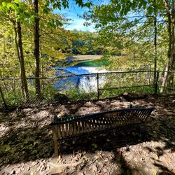
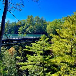
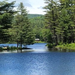
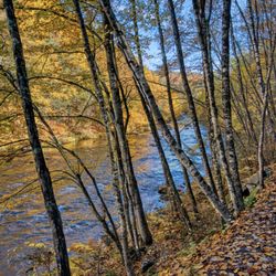
Stoughton Pond Recreation Area Photos
You might also consider
More like Stoughton Pond Recreation Area
Recommended Reviews - Stoughton Pond Recreation Area
Start your review...

15 years ago


14 years ago
More info about Stoughton Pond Recreation Area
98 Reservoir Rd
Springfield, VT 05156
Directions
Hours
Outdoor Amenities


Stoughton Pond Recreation Area - parks - Updated May 2026
Best of Springfield
People found Stoughton Pond Recreation Area by searching for…
Fun Things to Do in Springfield, VT
Playgrounds in Springfield, VT
Places to Swim in Springfield, VT
Hiking Trails in Springfield, VT
Public Indoor Swimming Pools in Springfield, VT
Picnic Areas in Springfield, VT
Kids Friendly Beaches in Springfield, VT
Lakes & Ponds in Springfield, VT
Kids Birthday Party Venues in Springfield, VT
Picnic Spots in Springfield, VT
Things to Do on a Rainy Day in Springfield, VT
Walking Trails in Springfield, VT
Playgrounds for Kids in Springfield, VT
Swimming Lakes in Springfield, VT
Running Track in Springfield, VT
Public Showers in Springfield, VT
Hiking Trails Kid Friendly in Springfield, VT
Trending Searches in Springfield, VT
Botanical Gardens near Stoughton Pond Recreation Area
Bounce House Rentals near Stoughton Pond Recreation Area
Campgrounds near Stoughton Pond Recreation Area
Fishing Spots near Stoughton Pond Recreation Area
Floral Designers near Stoughton Pond Recreation Area
Flower Shop near Stoughton Pond Recreation Area
Garage Sales near Stoughton Pond Recreation Area
Garden Center near Stoughton Pond Recreation Area
Hot Tub & Pool near Stoughton Pond Recreation Area
Lakes near Stoughton Pond Recreation Area
Lookout Points near Stoughton Pond Recreation Area
Nurseries & Gardening near Stoughton Pond Recreation Area
Outdoor Activities near Stoughton Pond Recreation Area
Outdoor Furniture Stores near Stoughton Pond Recreation Area
Party Equipment Rentals near Stoughton Pond Recreation Area
Pedicure near Stoughton Pond Recreation Area
Photo Spots near Stoughton Pond Recreation Area
Picnic Areas near Stoughton Pond Recreation Area
Playgrounds near Stoughton Pond Recreation Area
Pool Supplies near Stoughton Pond Recreation Area
Public Shower near Stoughton Pond Recreation Area
Rv Rental near Stoughton Pond Recreation Area
Salt Water Pool near Stoughton Pond Recreation Area
Soccer Fields near Stoughton Pond Recreation Area
Splash Pad near Stoughton Pond Recreation Area
Spray Tanning near Stoughton Pond Recreation Area
Swimming Holes near Stoughton Pond Recreation Area
Toddler Activities near Stoughton Pond Recreation Area
Watch Sunset near Stoughton Pond Recreation Area
Browse Articles
Browse Nearby
BEST of Springfield, Vermont Things to Do near Stoughton Pond Recreation Area
BEST of Springfield, Vermont Playgrounds near Stoughton Pond Recreation Area
BEST of Springfield, Vermont Restaurants near Stoughton Pond Recreation Area
BEST of Springfield, Vermont Hiking near Stoughton Pond Recreation Area
BEST of Springfield, Vermont Coffee near Stoughton Pond Recreation Area
BEST of Springfield, Vermont Campgrounds near Stoughton Pond Recreation Area
BEST of Springfield, Vermont Breakfast near Stoughton Pond Recreation Area
Browse Brands
Related Searches in Springfield, VT
Affordable Kayak Rental Services in Springfield, Vermont
Best Fishing Locations and Guides in Springfield, Vermont
Best Fun Things to Do in Springfield, Vermont
Best Parks for Parties and Events in Springfield, Vermont
Best Places for Horseback Riding in Springfield, Vermont
Best Places for Stunning Views in Springfield, Vermont
Best Things to Do on a Rainy Day in Springfield, Vermont
Best Water Parks for Kids in Springfield, Vermont
Browse Top Hotels in Springfield, Vermont for Your Stay
Check Out Great Playgrounds in Springfield, Vermont
Discover Popular Photo Spots in Springfield, Vermont
Discover Scenic Beach Camping Sites in Springfield, Vermont
Discover Soccer Fields in Springfield, Vermont Near You
Discover Top Nature Parks to Visit in Springfield, Vermont
Discover the Best Beaches in Springfield, Vermont
Discover the Best Sunset Cruise Tours in Springfield, Vermont
Enjoy the Best Family Activities in Springfield, Vermont
Enjoy the Best Picnic Spots and Ideas in Springfield, Vermont
Enjoy the Best Tubing Experiences in Springfield, Vermont
Enjoy the Best Walking Trails in Springfield, Vermont
Enjoy the Scenic Boardwalk Attractions in Springfield, Vermont
Experience Stunning Sunset Views in Springfield, Vermont
Explore Beautiful Botanical Gardens in Springfield, Vermont
Explore Beautiful Parks and Green Spaces in Springfield, Vermont
Explore Bike Rentals Throughout Springfield, Vermont
Explore Easy Hikes Perfect for All in Springfield, Vermont
Explore Free Picnic Areas Around Springfield, Vermont
Explore Free Things to Do Around Springfield, Vermont
Explore Landmarks & Historical Buildings in Springfield, Vermont
Explore Off Leash Dog Beaches in Springfield, Vermont
Explore Parks With Pull Up Bars in Springfield, Vermont
Explore Popular Campgrounds Near Springfield, Vermont
Explore Popular Picnic Areas Around Springfield, Vermont
Explore Popular RV Parks Around Springfield, Vermont
Explore Popular Scenic Views Near Springfield, Vermont
Explore Scenic Lakes to Visit in Springfield, Vermont
Explore Secret Spots Worth Visiting in Springfield, Vermont
Explore Summer Camps for All Ages in Springfield, Vermont
Explore Top Dog Parks in Springfield, Vermont Near You
Explore Top Gyms in Springfield, Vermont Now
Explore Top Marinas Near Springfield, Vermont
Explore Top Water Parks in Springfield, Vermont Today
Explore the Best Swimming Holes Around Springfield, Vermont
Find Beautiful Views in Springfield, Vermont
Find Parks and Recreation Activities in Springfield, Vermont
Find Top Dog Swimming Spots in Springfield, Vermont
Find Top Skate Parks in Springfield, Vermont for All Skill Levels
Find Top Skating Rinks in Springfield, Vermont for All Ages