St. Thomas Site Loop Trail Photos


You might also consider
More like St. Thomas Site Loop Trail
Recommended Reviews - St. Thomas Site Loop Trail
Start your review...

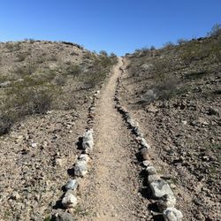
I first visited St. Thomas in 2007 and I only had a paper map I had printed to give me some idea what I was looking at. When you're trying to compare a street grid with dirt trails in the desert it can be difficult to know what you're looking at. Now a decade plus later, the National Park Service has installed many interpretive markers with lots of information and many have maps so you can see what you're looking at and where the loop trail goes. Have a Nevada State Parks pass, I drove up the 15 and got off and came through Valley of Fire State Park. At the east entrance to VOF, you make a turn south on Northshore Road. Just after the Lake Mead NRA fee booth, there's a dirt road that is on the left. That's the road that's marked with a sign that says St. Thomas Cove. You travel a well graded dirt road for three miles to the parking area for the hike. From the parking area, the trail starts down a hill and in 3/10 of a mile, you're on flat ground. It's amazing to think that you're walking where Lake Mead once covered the area. There are freshwater clam shells all around. Eventually, you come to a junction where there are two interpretive markers. This is the beginning of the loop hike and you can complete the loop either clockwise or counter clockwise. Make sure you read the markers as they have great information on the history of St. Thomas and the foundations at which you're looking. The cooler weather is the best time to go. The summer heat would make this an unpleasant and dangerous hike. There is a pit toilet a short distance away from the parking area in what was a place where the road went to the lake to launch boats. read more


8 years ago
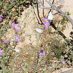
Spent Earth Day hiking this trail for a local history lesson with some friends. Check the other review for the background info, but know to come with a hat and/or sunscreen and plenty of water, as there is no shade on this trail. The loop takes you through the remains of a former city, hence the name. There are websites you can pull up to look up info on each of the sites as you go, from the old general store to the ice cream shop and more. The trail is clear and you can venture off of it easily. More than the various human artifacts, my favorite part was being able to walk through the dessert and see hundreds of sea shells crunching underfoot. It's surreal to think that it really wasn't that long ago that all of this was underwater. Trail is dog-friendly and is located in the Lake Meade area, requiring a car entry fee. There's also a museum in town to get more info related to this area. Pop into Sugar's for a meal before or after. read more


An amazing piece of history. The town of St. Thomas was abandoned once Hoover Dam was build and the waters began backing up behind the dam. For years the town sat underneath Lake Mead. Due to the lengthy drought the water has receded revealing what is left of this town. There's not much but have buried foundations. You can see the remains of trees that once lined the streets. It really is rather eerie walking around realizing that around 100 years ago peoples entire lives were lived right where you're walking around. It's not a very long hike. I'm guessing around 2 miles round trip. Be careful in the summertime and bring plenty of water. There's no shade to be found anywhere out there. Definitely worth a half a day trip from Vegas to drive out and check things out. read more


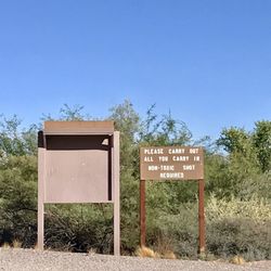
Here's something different to check out at Lake Mead: St Thomas! It's a little known treasure and worth the drive out of town! A former town that once was on the lake floor and now it is exposed. Here's a little background. The town was originally inhabited by Mormons who didn't realize they were in Nevada. When NV wanted some $$, the Mormons burned the place done and left (except for one family who stayed behind). In the early 1900s the town was settled again. But low and behold...the dam conceived. The newfound settlers were asked to leave when the lake was filled. As the story goes, the last man woke up to water at his feet and rowed a boat out of there. But true to his Mormon predecessors, he set fire to his abode before bidding adieu. Since lake was filled, St Thomas was once only accessible to divers because it was completely underwater - 60 feet at times. But now, the Lake level is low and this gem can be accessed by foot. It's an easy hike and dog friendly. Location: north on I15, exit the Valley of Fire/Lake Mead exit. Enter lake mead, past the fee station, first right just after the fee station (there's a sign). Take the dirt road approximately 1-2 miles to the trailhead with an interpretative sign. Follow the trail to the town. Note: there is a fee to drive through the Valley of Fire and a separate fee to enter Lake Mead. The Valley of Fire fee can be avoided by going through the town of Overton, but it's ~20 miles out of the way and not nearly as scenic! What you see: lots of building foundations (homes, a school, church, ice cream parlor, general store...) roads, walkways, glass bottles, and cisterns. Other info: Don't expect to be lakeside for this hike. You'll have to get back in your car to experience water. With that said, bring a gallon per person & dog. This is an easy hike. Ask the park ranger at the fee station for a map. This will be handy, as you can identify the buildings you are looking at. There aren't any interpretative signs on the trail (it was under water for until recently). If there isn't a ranger, you can download a copy from the NPS website. Helpful links: http://travelnevada.com/discover/26443/st-thomas-ghost-town https://www.nps.gov/lake/learn/nature/st-thomas-nevada.htm read more


More info about St. Thomas Site Loop Trail
You might also consider


St. Thomas Site Loop Trail - hiking - Updated July 2026
Best of Moapa Valley
People found St. Thomas Site Loop Trail by searching for…
Abandoned Places in Moapa Valley, Nevada
River Swimming in Moapa Valley, Nevada
Watch Fireworks in Moapa Valley, Nevada
Things to Do in Moapa Valley, Nevada
Fishing Lake in Moapa Valley, Nevada
Sand Dunes in Moapa Valley, Nevada
Off Road Trails in Moapa Valley, Nevada
Hiking Trails in Moapa Valley, Nevada
Fishing Spots in Moapa Valley, Nevada
Bonfires in Moapa Valley, Nevada
Abandoned Buildings in Moapa Valley, Nevada
Ghost Towns in Moapa Valley, Nevada
Easy Hikes in Moapa Valley, Nevada
Fishing Ponds in Moapa Valley, Nevada
Fireworks in Moapa Valley, Nevada
Scenic Drive in Moapa Valley, Nevada
Boating in Moapa Valley, Nevada
Dinosaur Park in Moapa Valley, Nevada
24 Hour Parking in Moapa Valley, Nevada
Scenic Views in Moapa Valley, Nevada
Swimming Lakes in Moapa Valley, Nevada
Trending Searches in Moapa Valley, NV
Fireworks near St. Thomas Site Loop Trail
Fishing Spots near St. Thomas Site Loop Trail
Kids Activities Outdoor near St. Thomas Site Loop Trail
Lakes near St. Thomas Site Loop Trail
Off Road Trails near St. Thomas Site Loop Trail
Public Pools near St. Thomas Site Loop Trail
Public Shower near St. Thomas Site Loop Trail
River Swimming near St. Thomas Site Loop Trail
Running Trails near St. Thomas Site Loop Trail
Splash Pad near St. Thomas Site Loop Trail
Strawberry Picking near St. Thomas Site Loop Trail
Swimming Holes near St. Thomas Site Loop Trail
Swimming Lakes near St. Thomas Site Loop Trail
Watch Sunset near St. Thomas Site Loop Trail
Browse Articles
Browse Brands
Related Searches in Moapa Valley, NV
Best Fishing Locations and Guides in Moapa Valley, Nevada
Best Fun Things to Do in Moapa Valley, Nevada
Best Places for Horseback Riding in Moapa Valley, Nevada
Best Spots for Star Gazing in Moapa Valley, Nevada
Check Out Off Road Trails in Moapa Valley, Nevada
Discover Dog Friendly Trails to Explore in Moapa Valley, Nevada
Discover Fun Activities to Do in Moapa Valley, Nevada
Discover Popular Photo Spots in Moapa Valley, Nevada
Discover Scenic Mountain Bike Trails Near Moapa Valley, Nevada
Discover Top Boat Tours in Moapa Valley, Nevada for All Ages
Discover the Best Beaches in Moapa Valley, Nevada
Discover the Best Night Hike Trails in Moapa Valley, Nevada
Dog-Friendly Hikes With Dogs in Moapa Valley, Nevada
Enjoy Camping Adventures Around Moapa Valley, Nevada
Enjoy Fishing With Kids in Moapa Valley, Nevada Safely
Enjoy Hiking Adventures in Moapa Valley, Nevada
Enjoy Jet Ski Adventures in Moapa Valley, Nevada
Enjoy Tent Camping Spots Around Moapa Valley, Nevada
Enjoy the Best Tubing Experiences in Moapa Valley, Nevada
Enjoy the Best Walking Trails in Moapa Valley, Nevada
Explore Beautiful Botanical Gardens in Moapa Valley, Nevada
Explore Beautiful Parks and Green Spaces in Moapa Valley, Nevada
Explore Bike Rentals Throughout Moapa Valley, Nevada
Explore Easy Hikes Perfect for All in Moapa Valley, Nevada
Explore Family-Friendly Zoos and Wildlife in Moapa Valley, Nevada
Explore Free Picnic Areas Around Moapa Valley, Nevada
Explore Free Things to Do Around Moapa Valley, Nevada
Explore Fun Activities to Do in Moapa Valley, Nevada
Explore Landmarks & Historical Buildings in Moapa Valley, Nevada
Explore Popular Campgrounds Near Moapa Valley, Nevada
Explore Popular Picnic Areas Around Moapa Valley, Nevada
Explore Popular RV Parks Around Moapa Valley, Nevada
Explore Popular Recreation Centers Around Moapa Valley, Nevada
Explore Popular Scenic Views Near Moapa Valley, Nevada
Explore Scenic Lakes to Visit in Moapa Valley, Nevada
Explore Summer Camps for All Ages in Moapa Valley, Nevada
Explore Top Dog Parks in Moapa Valley, Nevada Near You
Explore Top Gyms in Moapa Valley, Nevada Now
Explore Top Marinas Near Moapa Valley, Nevada
Explore Top Water Parks in Moapa Valley, Nevada Today
Explore the Best Boating Spots in Moapa Valley, Nevada
Find Beautiful Views in Moapa Valley, Nevada
Find Cozy Camping Cabins in Moapa Valley, Nevada
Find Parks and Recreation Activities in Moapa Valley, Nevada
Find Popular Ziplining Spots Around Moapa Valley, Nevada
Find Top Outdoor Gear Stores in Moapa Valley, Nevada
Find Top Skate Parks in Moapa Valley, Nevada for All Skill Levels
Find Top Skating Rinks in Moapa Valley, Nevada for All Ages