Cancel

    Open app

    Search

    Sprague Pond Trail

    5.0 (1 review)

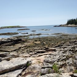
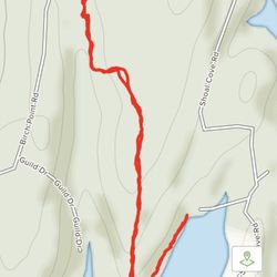
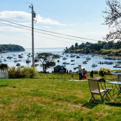
    Sprague Pond Trail Photos

    You might also consider

    Recommended Reviews - Sprague Pond Trail

    Your trust is our priority, so businesses can't pay to alter or remove their reviews. Learn more about reviews.
    Yelp app icon
    Browse more easily on the app
    Review Feed Illustration

    4 years ago

    Sprauuuuuugeeee. Solid trail. Best around, one could say. But stay away, I want her all to myself...

    Helpful 0
    Thanks 0
    Love this 0
    Oh no 0

    Verify this business for free

    People searched for Hiking 205 times last month within 15 miles of this business.

    Verify this business

    Higgins Mountain Preserve - Trail marker.

    Higgins Mountain Preserve

    (2 reviews)

    Quick little hike up a quiet path. Doesn't seem to be a popular spot to hike which makes it even…read morebetter- unpopular=quiet. I did this hike after meeting a new client just down the road. I parked on their off road parking area and started my ascent. The path is well maintained, peaceful, and well marked with cairns when there is areas that would otherwise be confusing to which way to go. While the top wasn't as scenic as many of the mountains I have accomplished over the years, it was a nice place to sit, relax, and reflect in the quiet.

    If you're a day hiker, a quick hiker, a nature walker, a fresh air lover, a geocacher, or just like…read moreto move your body, check out Higgins Mountain Preserve. It's about a .5 mile loop around a parcel of land that was donated in 2000 to the Kennebec Estuary Land Trust. It's the highest point on Georgetown being 259 feet above sea level. We decided to check it out because of the promise we saw when researching that we'd see "stunning views of the coast" (like Monhegan Island, Seguin Island, and the Gulf of Maine). It's unmarked from the road, so if you're driving down Route 27, be careful not to drive past it (when your GPS tells you you're there, you're actually there... just look for the incredibly small dirt pull-off). The hike/walk itself was much more uphill than I was expecting, but was beautiful - from the dense forest at the bottom to the beautiful sprawling lichen at the top and the wild blueberry bushes - throughout. We're also suckers for "rock art" (as we call it); which are, as you probably know, just piles of delicately balanced rocks acting as trail markers. This hike/walk had them every few feet on the path to reassure us that we were where we were supposed to be. Loved this - and love that the people using Higgins are a) leaving everything as they found it and b) practicing carry in/carry out (the mountain was in pristine condition, not a single piece of litter anywhere - hurray for humanity on this one!). When we reached the top, we didn't see any ocean though and it was a clear summer day. We both assumed that "views of the coast" meant actual water views. Not the case - at least not in the height of summer. Maybe when the trees are less full you can see more, but our scenery was a thousand shades of green tree tops. Still beautiful, but not what we wanted. I would absolutely come back here maybe at the peak of, or just past, foliage season for the views and a quick jaunt in Mother Nature.

    Wilbur Preserve

    Wilbur Preserve

    (2 reviews)

    I feel the need to preface all of my nature reviews with this: being 90% forested and having around…read more3500 miles of coastline, Maine has a tremendous amount of spaces, walkways, paths, and trails of all kinds and of all levels. There's something for everyone. What I'm reviewing is how a spot compares to similar outdoor spots in my personal opinion. Being in nature - and remembering to carry in, carry out - is always five stars! :) Parking? Kind of. Loop trail? No. Well marked signs? Yes. Element of surprise? Yes. The most challenging part about Wilbur's Preserve at Cox Head is the drive! It feels like you're going upta camp on some back roads that have hairpin turns, rollercoastery up and downs, and is barely wide enough for one car to drive on. I did a whole lot of honking (sorry to the neighbors who live in this area) to alert any oncoming vehicles that I was there! When you arrive there's a pull-off on the left for maybe two to four cars; this road (Green Point) also ends abruptly (as in, if you kept driving you'd be in the sea). Maybe a couple more cars could park at the end, but I don't know if it's allowed. The trail is about a half mile, and it's of those low risk, extremely high reward kind of hikes. The walk up is a bit uphill and steep-ish in some parts; the path can be quite shallow with somewhat of a drop-off to one side, but you get to the summit of Cox's Head sooooooooo quickly. And from these ledges are just absolutely spectacular, sweeping views overlooking Atkin's Bay, Popham Beach, Fort Popham, a couple lighthouses (bring your binoculars!!!), and open ocean. It was just such a breathtaking sight for minimal effort. (SIDE NOTE: there's two trails - the one up to the scenic overlook and a side one off of this main one called "Old Tree Loop". That tree trail is overgrown, and despite it being autumn, I still had thorns tugging at my clothing as I tried to squeeze through it. Personally, I'd skip it [especially during tick season]; there's nothing to look at on it anyway!)

    Short hike to an amazing view of the river, bay and ocean . The trail is well marked and not…read moredifficult to climb to the top .

    Bijhouwer Forest

    Bijhouwer Forest

    (2 reviews)

    This is a lovely loop trail. We visited in the fall so there was no waterfall but even without it…read moreis a nice hike. The big rocks are definitely worth seeing. Our hike took about an hour. The trail is well-marked with painted blue dots on the trees. The hardest part is finding the trail. These directions are copied from the Phippsburg land trust website: Follow Route 209 into Phippsburg, if coming from out of town. At the Stony Brook Road, turn right (the Stony Brook Road is about 3.5 miles from the causeway at the Phippsburg/Bath town line). Devil's Highway is a left hand turn about .6 miles from the start of the Stony Brook Road. It is not always well signed (kids tend to run off with the road sign), but it is a dirt road with a fairly wide opening onto the Stony Brook Road with mailboxes. The left turn comes just as the Stony Brook Road is making a noticable turn.. If you've come to the Fuller Mountain Road, a similar left hand turn, you've gone too far. The parking area is on the left as you travel Devil's Highway; I believe it is about .4 miles onto Devil's Highway. It is just past the third house on the right, I believe. You can't see it on the Google Earth map, because it is a small wooded parking area (perhaps 4 cars can park there). If you come to the the area where there is a side road off to the left with houses, you've gone too far. There is a small PLT sign in the parking area.

    I feel the need to preface all of my nature reviews with this: being 90% forested and having around…read more3500 miles of coastline, Maine has a tremendous amount of spaces, walkways, paths, and trails of all kinds and of all levels. There's something for everyone. What I'm reviewing is how a spot compares to similar outdoor spots in my personal opinion. Being in nature - and remembering to carry in, carry out - is always five stars! :) Parking? Yes. Loop trail? Yes. Well marked signs? Yes. Element of surprise? Yes. This is one of my favorite little hikes in Maine. I fell in love with it immediately (even if I can't remember the name and keep calling it the Bijou Flower Forest). It has my favorite four things: parking, a loop trail, extremely well marked signs, and constant elements of surprise that even if you know about because you read about them online are *STILL* amazing when you see them in real life. The trails are extremely well maintained and easy to navigate. You first come into a meadow; and then, there's another meadow to your right, but to the left is the forest itself. The ever present sign of what is located where allows you to lose yourself in the beauty of this natural space because you know you can't lose your way. Waterfall this way. Hundred foot rock this way. Laurel this way. And what a lovely waterfall it is. You can hear it rushing before you approach it. There's a little bench placed literally directly in front of it so you can just sit and be. The brook it creates winds along much of the rest of the trail you'll take so expect to crisscross it a few times via bridge or plank or even a big ol' hop. (NOTE: I can't speak to what this place looks like in a summer drought, but I came in autumn after some rain and it was a spectacular sight, and loud too! I bet it's just as stunning in spring.) The hundred foot rock is unexpected even though there are signs for it. Because, you look up and suddenly it isn't just trees around you but a literal massive boulder. Regarding the laurel, alas I didn't see it when I came because it's in bloom in June and July, I think. Apparently it's one of the northernmost stands of mountain laurels in New England, so you know I'll be back next summer. While I didn't see any flowers, I did see an abundance of rock tripe, which honestly looked like giant scales of some mythical creature (it's really just lichen). Magical? This place is absolutely that.

    Bates-Morse Mountain Conservation Area

    Bates-Morse Mountain Conservation Area

    (2 reviews)

    Great 2 mile hike to the beach (4mi total). Easy, free parking at the trailhead. This is an easy…read morehike that even little ones can do. Mostly shaded. But y'all, DO NOT FORGET THE BUG SPRAY. Let's say you arrive, start walking, and remember shoot! We left the bug spray in the car! TURN AROUND AND GET THE BUG SPRAY. Let's say you arrive, start walking, and remember shoot! We left the bug spray in the hotel! TURN AROUND, DRIVE HOME AND GET THE BUG SPRAY. I'm not exaggerating here - the bugs are a HUGE issue. We *gasp!* FORGOT THE BUG SPRAY, and suffered the consequences for the next 3 days of our trip. Literally hundreds of bites on every person. DO NOT NEGLECT TO BUG SPRAY. That aside, this was AWESOME!!! Such a gorgeous hike and then the beach!! THE BEACH!! Amazing. We visited Popham State Park later in the week and it could not compare to the beauty of this secluded beach. We were almost the only ones there! I wish I had understood how lovely it would be in advance... I would have packed a backpack lunch and spent the day there. As it was, we were all fully clothed but that didn't stop most of us from getting in the water. Do plan to spend some time here!

    Such a lovely 4 mile hike. This place has everything. Marshes, forests , mountain, and a beach…read more The day was sunny and 38 and oh breathtaking. I have hiked here a lot. In July and August there are a lot of insects that bite so I would avoid it then. Otherwise this place is a gem. The ocean water at the beach was super sparkly. Gorgeous. Maine is nice ...worth a memory worth a lifetime!! Enjoy

    Ridgewell Preserve

    Ridgewell Preserve

    (1 review)

    I feel the need to preface all of my nature reviews with this: being 90% forested and having around…read more3500 miles of coastline, Maine has a tremendous amount of spaces, walkways, paths, and trails of all kinds and of all levels. There's something for everyone. What I'm reviewing is how a spot compares to similar outdoor spots in my personal opinion. Being in nature - and remembering to carry in, carry out - is always five stars! :) Parking? Yes. Loop trail? Yes and no. Well marked signs? Kind of. Element of surprise? No. It can be easy to zoom past this location if you're not searching for it. Note that parking is actually just off the road; definitely *do not* follow Google Map's advice of going up the dirt hill behind the pull-off as that's someone's driveway! The trailhead itself is just off to the right. For me, this was nothing more than a very long walk in the woods -- some of the trails are very clearly marked (orange, yellow, red); some of which are not (blue could use a repaint). The trail is very, very windy and rooty. Can trails have hairpin turns? Because this one did. Oh, and when I visited there was a thick layer of fallen leaves also making it quite a slippery hike as well. My knees definitely felt this path hours later. I came because of Dinosaur Rocks - "a must" many people said on hiking forums, but they're really just boulders that the trail goes up. They aren't laid out or fallen or placed in any unique or interesting way. They aren't shaped in any unique or interesting way. They aren't unique or interesting in any visual sort of way. And, there's no real view once you've walked up them either. In full disclosure I didn't hike every inch of every trail on this one because... I was just underwhelmed right from the beginning. I did get unexpectedly *very close* to a deer when I rounded a corner of a trail and we both spooked each other though! So there's that.

    Johnson Field Preserve and Mackerel Cove

    Johnson Field Preserve and Mackerel Cove

    (3 reviews)

    This is a great natural place if you have a chance to visit. I was hear for a wedding and it made a…read moremagnificent backdrop. The couple loves nature and are often out rowing and hiking. This place made their special day even more special. This is also a great backround for pictures that are picturesque and won't be soon forgotten. Getting here is no treat, though. There is not much parking and walking can be challenging with a huge hill to walk down to get here.

    I know that Mackeral Cove is stunning and a picturesque spot (driving by, you can't help but have…read moreyour breath taken away at the perfect scene: blue waters, lobster boats, it's charming!), but every time I came this past winter the beach was absolutely covered in trash. Shattered glass, crushed cans, piles of takeout containers/wrappers, plastic chunks broken off of who knows what, lobster bands everywhere, cigarette butts, you name it. I completely understand and respect that this is a working waterfront, but I've never actually seen anything quite this disgusting on the Maine coast before (I've lived here all my life). Yes, we did our part to pick as much up as we could; and, who knows, maybe folks go out of their way to keep it much cleaner in the nicer weather. But as a local who frequents this area? I'm all set right now. If you're out this way, visit Land's End and Giant's Stairs Trail, but let the visual you get simply from passing by Mackerel Cove be enough.

    Sprague Pond Trail - hiking - Updated May 2026

    Loading...
    Loading...
    Loading...