Bijhouwer Forest Photos


You might also consider
More like Bijhouwer Forest
Recommended Reviews - Bijhouwer Forest
Start your review...

8 months ago
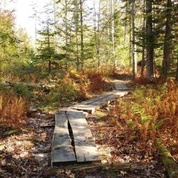
This is a lovely loop trail. We visited in the fall so there was no waterfall but even without it is a nice hike. The big rocks are definitely worth seeing. Our hike took about an hour. The trail is well-marked with painted blue dots on the trees. The hardest part is finding the trail. These directions are copied from the Phippsburg land trust website: Follow Route 209 into Phippsburg, if coming from out of town. At the Stony Brook Road, turn right (the Stony Brook Road is about 3.5 miles from the causeway at the Phippsburg/Bath town line). Devil's Highway is a left hand turn about .6 miles from the start of the Stony Brook Road. It is not always well signed (kids tend to run off with the road sign), but it is a dirt road with a fairly wide opening onto the Stony Brook Road with mailboxes. The left turn comes just as the Stony Brook Road is making a noticable turn.. If you've come to the Fuller Mountain Road, a similar left hand turn, you've gone too far. The parking area is on the left as you travel Devil's Highway; I believe it is about .4 miles onto Devil's Highway. It is just past the third house on the right, I believe. You can't see it on the Google Earth map, because it is a small wooded parking area (perhaps 4 cars can park there). If you come to the the area where there is a side road off to the left with houses, you've gone too far. There is a small PLT sign in the parking area. read more


I feel the need to preface all of my nature reviews with this: being 90% forested and having around 3500 miles of coastline, Maine has a tremendous amount of spaces, walkways, paths, and trails of all kinds and of all levels. There's something for everyone. What I'm reviewing is how a spot compares to similar outdoor spots in my personal opinion. Being in nature - and remembering to carry in, carry out - is always five stars! :) Parking? Yes. Loop trail? Yes. Well marked signs? Yes. Element of surprise? Yes. This is one of my favorite little hikes in Maine. I fell in love with it immediately (even if I can't remember the name and keep calling it the Bijou Flower Forest). It has my favorite four things: parking, a loop trail, extremely well marked signs, and constant elements of surprise that even if you know about because you read about them online are *STILL* amazing when you see them in real life. The trails are extremely well maintained and easy to navigate. You first come into a meadow; and then, there's another meadow to your right, but to the left is the forest itself. The ever present sign of what is located where allows you to lose yourself in the beauty of this natural space because you know you can't lose your way. Waterfall this way. Hundred foot rock this way. Laurel this way. And what a lovely waterfall it is. You can hear it rushing before you approach it. There's a little bench placed literally directly in front of it so you can just sit and be. The brook it creates winds along much of the rest of the trail you'll take so expect to crisscross it a few times via bridge or plank or even a big ol' hop. (NOTE: I can't speak to what this place looks like in a summer drought, but I came in autumn after some rain and it was a spectacular sight, and loud too! I bet it's just as stunning in spring.) The hundred foot rock is unexpected even though there are signs for it. Because, you look up and suddenly it isn't just trees around you but a literal massive boulder. Regarding the laurel, alas I didn't see it when I came because it's in bloom in June and July, I think. Apparently it's one of the northernmost stands of mountain laurels in New England, so you know I'll be back next summer. While I didn't see any flowers, I did see an abundance of rock tripe, which honestly looked like giant scales of some mythical creature (it's really just lichen). Magical? This place is absolutely that. read more


More info about Bijhouwer Forest
Devils Hwy
Phippsburg, ME 04562
Directions
Hours
Outdoor Amenities


Bijhouwer Forest - hiking - Updated June 2026
Best of Phippsburg
People found Bijhouwer Forest by searching for…
Hiking Trails With Waterfalls in Phippsburg, Maine
Things to Do in Phippsburg, Maine
Waterfalls in Phippsburg, Maine
Easy Hikes in Phippsburg, Maine
Waterfalls and Swimming Holes in Phippsburg, Maine
Walking Trails in Phippsburg, Maine
Off Leash Dog Hikes in Phippsburg, Maine
Running Trails in Phippsburg, Maine
Off Road Trails in Phippsburg, Maine
Scenic Night View in Phippsburg, Maine
Tourist Attractions in Phippsburg, Maine
Dog Friendly Trails in Phippsburg, Maine
Fun Things to Do With Kids in Phippsburg, Maine
Natural Hot Springs in Phippsburg, Maine
Watch Sunset in Phippsburg, Maine
Things to Do at Night in Phippsburg, Maine
Picnic Spots in Phippsburg, Maine
Browse Nearby
BEST of Phippsburg, Maine Restaurants near Bijhouwer Forest
BEST of Phippsburg, Maine Coffee near Bijhouwer Forest
BEST of Phippsburg, Maine Things to Do near Bijhouwer Forest
BEST of Phippsburg, Maine Breakfast near Bijhouwer Forest
BEST of Phippsburg, Maine Beaches near Bijhouwer Forest
BEST of Phippsburg, Maine Campgrounds near Bijhouwer Forest
Browse Brands
Browse Articles
People who viewed Bijhouwer Forest also viewed
Sprague Pond Trail
1 review
Mercy Pond Loop Trail
1 review
Valley Street
White Head Trail
2 reviews
Thorncrag Bird Sanctuary
5 reviews
Presumpscot River Preserve
3 reviews
North Deering
Mackworth Island State Park
6 reviews
Forest City Trail
2 reviews
Old Port
Otter Brook Preserve
2 reviews
Lobster Cove Trail
2 reviews
Cathance River Nature Reserve Trails
4 reviews