Cancel

    Open app

    Search

    Wilbur Preserve

    5.0 (2 reviews)

    Wilbur Preserve Photos

    You might also consider

    Recommended Reviews - Wilbur Preserve

    Your trust is our priority, so businesses can't pay to alter or remove their reviews. Learn more about reviews.
    Yelp app icon
    Browse more easily on the app
    Review Feed Illustration
    Photo of Steff D.
    4991
    1257
    20015

    5 years ago

    Helpful 15
    Thanks 0
    Love this 15
    Oh no 0
    Photo of D T.
    0
    3
    7

    13 years ago

    Helpful 1
    Thanks 0
    Love this 1
    Oh no 0

    Verify this business for free

    People searched for Hiking 161 times last month within 15 miles of this business.

    Verify this business

    Bijhouwer Forest

    Bijhouwer Forest

    5.0(2 reviews)
    4.0 mi

    This is a lovely loop trail. We visited in the fall so there was no waterfall but even without it…read moreis a nice hike. The big rocks are definitely worth seeing. Our hike took about an hour. The trail is well-marked with painted blue dots on the trees. The hardest part is finding the trail. These directions are copied from the Phippsburg land trust website: Follow Route 209 into Phippsburg, if coming from out of town. At the Stony Brook Road, turn right (the Stony Brook Road is about 3.5 miles from the causeway at the Phippsburg/Bath town line). Devil's Highway is a left hand turn about .6 miles from the start of the Stony Brook Road. It is not always well signed (kids tend to run off with the road sign), but it is a dirt road with a fairly wide opening onto the Stony Brook Road with mailboxes. The left turn comes just as the Stony Brook Road is making a noticable turn.. If you've come to the Fuller Mountain Road, a similar left hand turn, you've gone too far. The parking area is on the left as you travel Devil's Highway; I believe it is about .4 miles onto Devil's Highway. It is just past the third house on the right, I believe. You can't see it on the Google Earth map, because it is a small wooded parking area (perhaps 4 cars can park there). If you come to the the area where there is a side road off to the left with houses, you've gone too far. There is a small PLT sign in the parking area.

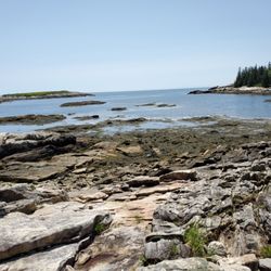
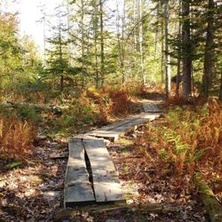
    I feel the need to preface all of my nature reviews with this: being 90% forested and having around…read more3500 miles of coastline, Maine has a tremendous amount of spaces, walkways, paths, and trails of all kinds and of all levels. There's something for everyone. What I'm reviewing is how a spot compares to similar outdoor spots in my personal opinion. Being in nature - and remembering to carry in, carry out - is always five stars! :) Parking? Yes. Loop trail? Yes. Well marked signs? Yes. Element of surprise? Yes. This is one of my favorite little hikes in Maine. I fell in love with it immediately (even if I can't remember the name and keep calling it the Bijou Flower Forest). It has my favorite four things: parking, a loop trail, extremely well marked signs, and constant elements of surprise that even if you know about because you read about them online are *STILL* amazing when you see them in real life. The trails are extremely well maintained and easy to navigate. You first come into a meadow; and then, there's another meadow to your right, but to the left is the forest itself. The ever present sign of what is located where allows you to lose yourself in the beauty of this natural space because you know you can't lose your way. Waterfall this way. Hundred foot rock this way. Laurel this way. And what a lovely waterfall it is. You can hear it rushing before you approach it. There's a little bench placed literally directly in front of it so you can just sit and be. The brook it creates winds along much of the rest of the trail you'll take so expect to crisscross it a few times via bridge or plank or even a big ol' hop. (NOTE: I can't speak to what this place looks like in a summer drought, but I came in autumn after some rain and it was a spectacular sight, and loud too! I bet it's just as stunning in spring.) The hundred foot rock is unexpected even though there are signs for it. Because, you look up and suddenly it isn't just trees around you but a literal massive boulder. Regarding the laurel, alas I didn't see it when I came because it's in bloom in June and July, I think. Apparently it's one of the northernmost stands of mountain laurels in New England, so you know I'll be back next summer. While I didn't see any flowers, I did see an abundance of rock tripe, which honestly looked like giant scales of some mythical creature (it's really just lichen). Magical? This place is absolutely that.

    Photos
    Bijhouwer Forest
    Bijhouwer Forest - This is the sign you'll see in the parking lot that holds just a few cars

    This is the sign you'll see in the parking lot that holds just a few cars

    Bijhouwer Forest

    See all

    Higgins Mountain Preserve - Trail marker.

    Higgins Mountain Preserve

    4.5(2 reviews)
    3.6 mi

    Quick little hike up a quiet path. Doesn't seem to be a popular spot to hike which makes it even…read morebetter- unpopular=quiet. I did this hike after meeting a new client just down the road. I parked on their off road parking area and started my ascent. The path is well maintained, peaceful, and well marked with cairns when there is areas that would otherwise be confusing to which way to go. While the top wasn't as scenic as many of the mountains I have accomplished over the years, it was a nice place to sit, relax, and reflect in the quiet.

    If you're a day hiker, a quick hiker, a nature walker, a fresh air lover, a geocacher, or just like…read moreto move your body, check out Higgins Mountain Preserve. It's about a .5 mile loop around a parcel of land that was donated in 2000 to the Kennebec Estuary Land Trust. It's the highest point on Georgetown being 259 feet above sea level. We decided to check it out because of the promise we saw when researching that we'd see "stunning views of the coast" (like Monhegan Island, Seguin Island, and the Gulf of Maine). It's unmarked from the road, so if you're driving down Route 27, be careful not to drive past it (when your GPS tells you you're there, you're actually there... just look for the incredibly small dirt pull-off). The hike/walk itself was much more uphill than I was expecting, but was beautiful - from the dense forest at the bottom to the beautiful sprawling lichen at the top and the wild blueberry bushes - throughout. We're also suckers for "rock art" (as we call it); which are, as you probably know, just piles of delicately balanced rocks acting as trail markers. This hike/walk had them every few feet on the path to reassure us that we were where we were supposed to be. Loved this - and love that the people using Higgins are a) leaving everything as they found it and b) practicing carry in/carry out (the mountain was in pristine condition, not a single piece of litter anywhere - hurray for humanity on this one!). When we reached the top, we didn't see any ocean though and it was a clear summer day. We both assumed that "views of the coast" meant actual water views. Not the case - at least not in the height of summer. Maybe when the trees are less full you can see more, but our scenery was a thousand shades of green tree tops. Still beautiful, but not what we wanted. I would absolutely come back here maybe at the peak of, or just past, foliage season for the views and a quick jaunt in Mother Nature.

    Photos
    Higgins Mountain Preserve - Wild blueberries!

    Wild blueberries!

    Higgins Mountain Preserve - Higgins Mountain Preserve.

    Higgins Mountain Preserve.

    Higgins Mountain Preserve - Pinecones.

    See all

    Pinecones.

    Bates-Morse Mountain Conservation Area

    Bates-Morse Mountain Conservation Area

    4.5(2 reviews)
    2.6 mi

    Great 2 mile hike to the beach (4mi total). Easy, free parking at the trailhead. This is an easy…read morehike that even little ones can do. Mostly shaded. But y'all, DO NOT FORGET THE BUG SPRAY. Let's say you arrive, start walking, and remember shoot! We left the bug spray in the car! TURN AROUND AND GET THE BUG SPRAY. Let's say you arrive, start walking, and remember shoot! We left the bug spray in the hotel! TURN AROUND, DRIVE HOME AND GET THE BUG SPRAY. I'm not exaggerating here - the bugs are a HUGE issue. We *gasp!* FORGOT THE BUG SPRAY, and suffered the consequences for the next 3 days of our trip. Literally hundreds of bites on every person. DO NOT NEGLECT TO BUG SPRAY. That aside, this was AWESOME!!! Such a gorgeous hike and then the beach!! THE BEACH!! Amazing. We visited Popham State Park later in the week and it could not compare to the beauty of this secluded beach. We were almost the only ones there! I wish I had understood how lovely it would be in advance... I would have packed a backpack lunch and spent the day there. As it was, we were all fully clothed but that didn't stop most of us from getting in the water. Do plan to spend some time here!

    Such a lovely 4 mile hike. This place has everything. Marshes, forests , mountain, and a beach…read more The day was sunny and 38 and oh breathtaking. I have hiked here a lot. In July and August there are a lot of insects that bite so I would avoid it then. Otherwise this place is a gem. The ocean water at the beach was super sparkly. Gorgeous. Maine is nice ...worth a memory worth a lifetime!! Enjoy

    Photos
    Bates-Morse Mountain Conservation Area - So peaceful

    So peaceful

    Bates-Morse Mountain Conservation Area
    Bates-Morse Mountain Conservation Area - I think I am outnumbered!

    See all

    I think I am outnumbered!

    Pott's Point Preserve - Distance, elevation, and time. Best mile of your life.

    Pott's Point Preserve

    5.0(4 reviews)
    12.1 mi

    Maine is full of secret nooks and crannies. Glorious, magnificent, breathtaking places untouched by…read moreman or time. It's getting increasingly difficult to find these places, but they exist and Pott's Point Preserve is proof of that. Driving to and around Harpswell in and of itself is stunning. But coming specifically here is otherworldly as far as nature scenes go. Park to the side of the road (carefully and at your discretion) at a seemingly dead-end near a bunch of lobster traps and a wharf. Walk up the private Pott's Point Road and walk for nearly a half mile through a picturesque, straight-out-of-a-movie-set seaside neighborhood. It may seem awkward to walk through (metaphorically) people's backyards, but eventually you'll reach "the end" of the road where there's a tiny, sandy path through thick greenery. Through it? The literal end of the land. A beautiful acre of rocks and rosa rugosa bushes and gravel beaches and tide pools full of marine life. You can loop around and explore (especially at low tide; you'll have to carefully navigate the rugged coastal landscape otherwise), and see a plethora of islands in the distance. It's unspoiled Maine beauty at it's finest.

    "The way life should be" - Maine's famous saying and logo - this place depicts just that. We went…read moreexploring and found this wonderful place. You're lost in time filled with algae, rocks, shells and grassland. We love this beautiful and breathtaking place. Perfect for puppies, children and couples. There is nothing quite like it and it's a short hike to the most gorgeous point. This place is perfect for this time of year- autumn with the leaves changing. Please come visit and find yourself at peace.

    Photos
    Pott's Point Preserve
    Pott's Point Preserve
    Pott's Point Preserve

    See all

    Widgeon Cove Trail - Parallel plank path.

    Widgeon Cove Trail

    5.0(2 reviews)
    9.9 mi

    I don't know what it's like to be a fairy or a gnome, and I'm often jealous of their woodland based…read morelifestyles (houses made in and of trees, drinking water out of flowers, riding on the back of squirrels... you know what I'm talking about). Widegon Cove Trail, however, has given me a sneak peek into that world. This unexpectedly beautiful path is a wonderfully maintained loop that cuts through thick, tall forest and circles past a cove with lovely pine tree and water views regardless of tide (although low tide offers more bird watching). It's well marked, and the trail itself is charming...at some points the ground is lined on either side with fallen trees to keep you on the path, parallel planks, and stone walkways too. Want to stop and take it all in? There are many wooden benches to stop and take it all in from. Does this sound like every other trail? Maybe. But there's really something charming and whimsical about this particular one. I don't know if it's the variety of trees, the ravine like parts, the moss and mushrooms, the abundance of wildlife, but I felt like I spent my entire walk (which was admittedly short; the whole loop is maybe half a mile?) smiling... and expecting Flora, Fauna, and Merryweather to come out of nowhere and begin singing to me.

    Follow this well maintained trail through woodlands to a beautiful view of Widgeon Cove…read more The parking lot is on the left heading when heading out of Brunswick and has enough space for four cars. The dirt was still loose near the road and I needed a slight angle to get out of the parking lot. There is the another one of the HHLT trails just before you get to this trail. If you are looking to lengthen your hike, you can walk or drive up to the other parking lot to check out the other trail. The following is taken from: www.hhltmaine.org/conserved-land/public-access/widgeon-cove-trail/ Ownership: Harpswell Heritage Land Trust trail on privately owned land Features: hiking, scenic view, benches, dogs allowed Length: .6 mile loop with cutoff trail Difficulty: moderate Hiking Time: 30 minutes Click here to download a trail map and brochure. Description: This half-mile loop trail is the perfect way to take in beautiful Widgeon Cove on Harpswell Sound. The path winds through woodlands, across ravines and along the shoreline where there is a dramatic view of the cove. At this scenic viewpoint, visitors can enjoy a picnic with family and friends, take pictures or just sit quietly to observe waterfowl, wading birds and other wildlife that frequent the cove. The Widgeon Cove Trail is part of the 88-acre Dunning Farm Conservation Easement. This privately owned property will remain forest and working farmland forever. Directions: From the intersection of Rt 123 and Bath Rd at Bowdoin College in Brunswick, follow Rt 123 south for 7.4 miles. Immediately after the Wilson's Cove Trail parking lot on the right, look for the Widgeon Cove Trail parking lot on the left. Visitor Guidelines: Carry in, carry out. Pedestrian use only. No overnight parking. No open fires. No camping. Dogs must be on a leash. Carry out all dog waste. Please respect wildlife, neighbors and other users. This trail is on private property. Please respect the owner's privacy. Power driven mobility devices are not allowed.

    Photos
    Widgeon Cove Trail - Widgeon Cove itself!

    Widgeon Cove itself!

    Widgeon Cove Trail - Widget Cove Trail!

    Widget Cove Trail!

    Widgeon Cove Trail

    See all

    Wilbur Preserve - hiking - Updated May 2026

    Loading...
    Loading...
    Loading...