Silver Comet Trail Photos


You might also consider
More like Silver Comet Trail
Recommended Reviews - Silver Comet Trail
Start your review...

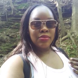
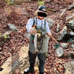
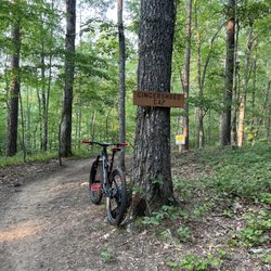
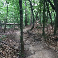
Reviews With Photos

Mavell Trailhead start ~ parking lot already full early morning, too tight for large vehicles to maneuver through. Park vehicle at neighboring Nickajack Elementary School for additional & easier parking and ride about 100 yards to entrance. Trailhead has restrooms. Starting at this trailhead on the weekend you will encounter a lot of congestion from all varieties for about 5 miles. Fun stops along the way ~ playgrounds, breweries & eateries. Grateful for this amazing ride and hope to check off the bucket list one day and ride the whole way to Alabama!


This is a great paved trail! I've walked at the start and rented bikes further in. There are a lot of entry points here because the trail is so long. I typically look for trails with bathroom access at the start and this has them along the trail. Some a clean...some not so much...If you're looking for a paved trail, I would highly recommend this. There aren't steep inclines so it's easy to bike or have strollers. The path is wide enough for people and bikers to pass easily. You cross over a few cool bridges too.

Road 20 miles east on this trail and ended up downtown Power Springs on a slight off trail road extravaganza! Downtown is just a two minute ride with signage to guide your journey. What i enjoy about the silver comet is that you have so many routes to choose from once you get started! There is plenty of wildlife on the ride from a turtle sanctuary to a horse ranch that still operates Did you know in the early 1850's Powder Springs was known as "Springsville" for the medicinal benefits that the water had to offer. It became a huge attraction and turned the town into a resort. The town of Powder Springs was reported incorporated as Springville in 1838 in the lands of two Cherokee Indian leaders. Gold had been discovered in Georgia ten years earlier, and the first European-American terrorist came to find gold. The settlers found little gold in the mines at Lost Mountain and off Brownsville Road. It was at about this time that the Cherokee people were forced off their land by colonizers and removed to Indian Territory west of the Mississippi River on the Trail of Tears. What a tragedy for the natives who lived there in peace.... But they did just elect Al Thurman for Mayor....

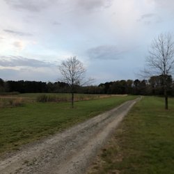
The Silver Comet Trail is a great part of the metro area and runs about 62 miles from Smyrna to the Alabama line where it then connects to the Chief Ladiga trail and goes for another 33 miles...so in total the trails combine for over 94 miles of paved trail for you to enjoy! Fun fact that I did not know is that both trails were created from abandoned railroads! I have been on many parts of the trail over the years, but now that I live in Smyrna I enter at the 2.6 mile point and travel pretty regularly between the 4.1 mark and the entry point at Mavell Road. This part runs well into Mableton, alongside the Nickajack Creek and crosses over East West Connector. Around the 2.6 marker there are several nature trail entrances that branch off of the paved portion of the trail. These break offs take you alongside the creek and depending on the way you walk you can see abandoned buildings and even end up at the base of the famed Concord Covered Bridge. We usually hit the trail twice a week and enter at the 2.6 mile mark as there is a small dedicated parking lot and pavilion that is part of the historic covered bridge district. Overall, the Silver Comet Trail is a great trail for all to use. You will see your standard walkers, joggers, bikers, skaters, roller bladers and apparently even catch a horse from time to time. The trail stays clean for the most part and the immediate sides remain well kept and free of debris as well. Only thing you have to watch out for are the not-so-great pup owners who do not clean up after their dogs. So, in short...we love the Silver Comet Trail! Sidenote...it is not a lit trail, so stay within daylight hours to ensure your safety!


A wonderful extensive trail with numerous trailheads. I was enchanted by the wooden bridges that have stood the test of time. the main trail segways into some multi-use trails that would be a nice opportunity to walk into the woods. The further you go from Atlanta, the more wooded and less populated the trail becomes. On my second trek, I started from Dallas and enjoyed biking into a quarry like path. I suggest looking up the interactive link which shows you the features of different points of the trail.


Great trail to run, walk, or bike on. Check out their website for all of the details but important points noted below: -wide trail allows bikers to maneuver around runners and plenty of room for people to go in both directions -trail is very well maintained and I always find it to be safe as a solo female runner -very flat :) -there are a few different areas along the long trail to park that have bathrooms and water

FYI: the Silver Comet Trail is a paved trail over 60 miles long and actually ends at the Bama / Georgia state line, where it meets another trail. Went skateboarding here with my friend, great spot. The trail is smooth and very shaded, so it's great for walking/running/biking as well. There are rest stops every few miles with bathrooms, water fountains, and parking. Great trail overall!
This place is very convenient, especially when you don't want to drive downtown to ride bikes or even walk on the trail. I came here last week by myself just to get away and find peace. There was quite a few people out. This time I decided to walk on the trail instead of renting a bike. I enjoyed my alone time

There are things to love about this trail... and there are definitely some things to hate about it as well. Let's cover both aspects. This trail is my go-to workout place. For the last 4-5 years I've become a rather avid cyclist, so my review is looking at the trail from a bicycle's perspective (trust me... quite different from when you're walking/jogging). The trail starts officially at Marvel Rd, which is behind the Publix off South Cobb Drive/East-West Connector. However, in the last couple of years, the city of Smyrna has built the Silver Comet Connector, which basically makes it possible to start the SCT (that's what the cool kids call it) on Atlanta Rd. The trail goes all the way to Alabama. So, as an average cyclist, you will never run out of trail. THE BRIGHT SIDE: (1) It's flat... really flat! There are some minor elevation changes that you really only notice because you find yourself breathing just a bit harder or riding a bit slower. I think total elevation change on the trail is 2%. It's a former railroad track that was paved over. (2) It's shady (for the most part). This is especially beneficial on those 90+ degree days in the summer (3) It's pretty (minus the parts where you drive past the water processing plant... blech! (4) Lots of rest stops, well marked, bathrooms with water fountains, and even a few bike stores along the way in case you have trouble. (5) No commercial traffic and very few stop lights THE NOT-SO-BRIGHT SIDE: (1) It gets really crowded. Especially on a beautiful Sunday afternoon. It becomes almost difficult to navigate, because you're constantly slowing down and speeding up, dodging the "traffic". (2) Speaking of traffic - when you are on the Silver Comet Trail, treat it like you would any other road. It has a yellow line in the middle after all. That means - stay to your right, and LOOK over your left shoulder before you pass someone, just in case there's someone even faster coming along behind you! Also, when you're entering the trail, remember to look and don't just walk blindly into the trail. People on bikes can potentially go pretty fast and it's difficult to stop on a dime. (3) Dog walkers - this trail is great for walking your dog. As long as you have a dog that is well trained and will stay close to you. There's been more than one occasion where the owner was walking on one side, but the dog was walking on the other side of the trail, essentially creating a long trap line with the leash... not cool! (4) Inexperienced and casual users of the trail can cause problems. That goes for joggers, bicyclists, skaters, etc. If it's difficult for you to keep a straight line on your bike, you may want to practice at home first before venturing out on the trail, where you could cause someone else to fall while you swerve back and forth. Also, if someone rides behind you and calls out "ON YOUR LEFT"... that means someone is coming up on your left. It does NOT mean jump to your left (yep, that's actually happened numerous times). So, with all that said - enjoy your ride on the SCT and I will likely see you there... !! read more


13 years ago
I truly enjoy the Silver Comet Trail. I've walked on this trail in the snow, the rain, and hellish heat, and I've enjoyed every moment. I discovered this walking/biking track when I lived in Vinings some odd years ago and even though I've moved, I still continue going there. I find it's usually best to go during the week in the morning or before everyone gets off work (before 6pm) to get in a serious workout.(this is cancelled out for holidays during the week) Also, the weekend is more crowded with families, bikers, dog walkers, joggers, plus more... so again the week days for working out, the weekend for more hanging out. I only walk on the trail, and in staying to the far right side of the track, I've never had a run in with bikers even when walking in a pair with my mother. Anyone on a trail is suppose to announce themselves in passing, but 99.9999% of the people on this trail do not, so I look out for myself and try not to get ran over. I'm also pretty tough and bitchy and if anyone runs into me, I suggest they flee for their lives!!! I park at the Mavell Road entrance and it can get very crowded by evening, so going down toward the middle or end can aid in a faster exit when trying to back your car out. Also this trail is well shaded but can become very VERY steamy after it rains and you'll be sweating in places that weren't suppose to sweat. But other than that, the trail is rather peaceful and quiet. There's lots of nature and yes it's going to attack your face such as bugs... bugs... and BUGS. So to wrap up my tale, I've used the restrooms at the Mavell Station once..... never again....never again..... Other than that... potty at home, enjoy your walk, be courteous to others, and break for squirrels!!! read more

11 years ago
I come here as often as I can. This trail stretches all the way to Alabama! It's a nice, even, and paved trail. The majority of the walk is shaded or covered. I usually go for a 5.2 miles walk with friends. Takes about 1.5 hours. Note: ton of bikers! Most go 90 to nothing so be careful! They do yell "Left!!!!" to let you know that they are passing you. Parking on the weekends can be hard, but you can park in the school lot or go to the other sections that has parking. Not at the start point 0.0 miles mark. There is an emergency call box at mile 1.5 miles. You can rent bikes as well! A great place for the family. read more

5 years ago
3 years ago
8 years ago
Nice nature trail for bike riding, running and walking. I took a beautiful walk with my family and our dogs for a 4 mile trek. It was a nice Saturday afternoon and relaxing scenery. I will definitely be back to enjoy again. read more

Best thing I've seen in any state I've lived in. I love & this trail. Converting old railroad tracks to a paved trail system. I've biked from powder springs to Austell & out to Hiram without an issue. Trails are constantly maintained & monitored by the local sheriff. I've seen the guys on numerous occasions while biking blowing & removing debris from the trail. The trail gets a variety of outdoor enthusiasts & you have a safe place to exercise while barely coming in contact with traffic. You cross traffic where a traffic light is installed maybe every 2 miles or so depending on the section of the trail. Heading towards Hiram has way less traffic interactions vs heading towards Smyrna. Beautiful trail! read more


6 years ago
5 years ago
13 years ago
This greenway, despite its weaknesses, is great for a few hours, or an entire day, outdoors. I'm not the sort to spend hours with a bike seat up my ass, and thus far haven't ridden a bike on the Silver Comet, so I can only speak for now of my impressions as someone who has walked/jogged the trail. I always park at the Mavell Road trailhead. It's usually busy, but I haven't yet been unable to find a space there. Plenty also park at Nickajack Elementary or at Highland Station (Publix). There are other paved and dirt lots to be found. It's like most rail-trails, except that it happens to be 60+ miles long. It's paved in asphalt, probably not quite 20' in width, and maintains a gentle grade. There are poorly designed curves approaching/leaving some of the bridges, where a total lack of visibility, and douchey cyclists' inherent desire to take curves as sharply as possible to save that quarter of a second, can make for some harrowing encounters. The trail itself is relatively well-maintained, except: * The wooden planks on at least one bridge have seen better days. You won't be re-enacting the climax of Temple of Doom, but if you're not vigilant you may have a bad day. * People are kind enough to (usually) clean up after their dogs, but they seem to believe that tossing bags of crap to the side of the trail is proper disposal. Which brings me to the lack of trash receptacles and the poor maintenance of restroom facilities... * There are almost no trash cans along the trail. The restrooms look as though they haven't been cleaned in weeks. Trail markers are huge and each likely cost at least a couple hundred dollars to install. Smaller distance markers would have saved money and those savings could have gone toward other uses, such as more garbage cans. Of course, paying crews to collect the trash and more regularly clean the restrooms is another story... Vegetation growth along the trail is controlled, but poison ivy is still one of the most prevalent plants I see within a few feet of the trail. By the way, to the dipshit driving the white RX 330: in case you were wondering why your kids' evening and next few days (and yours, as well... I really, really hope) were a bit hellish... Maybe next time, don't let them play Tarzan on just any vine they see in the woods. About 40% of the cyclists here on serious bikes, wearing serious costumes, ride recklessly in the presence of so many other people, and especially kids. The portion I've seen (up to Anderson Farm Road) is always filled with the rushing sound of nearby traffic, so you'll never be lulled into thinking you're more than a few hundred feet from those packed like lemmings into shiny metal boxes, so to speak. Generally, you see a little of everything along the Silver Comet. Most of the usual cast of trail characters are represented daily: * The elderly gentleman strolling with his portable CD player held up like a pizza box for the entirety of his walk. * The father who, either despite or because of his morbid obesity, proudly takes his kids for a ride but inexplicably fails to realize that a third of his ass is showing because his shirt is too short and his pants hang far too low. * The creepy old guy who turns his head with each passing female jogger, without any shame or attempt to conceal, because fuck you, you try going home each day and pushing rope into the wrinkles and folds of the woman you've been stuck with since 1973. * The gents who've read far too much Mark Frauenfelder... or Dr. Seuss... riding any number of bizarre, wheeled contraptions they either designed themselves or built from kits or bought from specialty shops for obscene prices. * The dude who smiles so brightly as he passes you... and then a few minutes later passes again going your way. And then smiles again a few minutes later as he again passes... and so on... I can only imagine women probably deal with the same sketchy shit, but even more often. * The girl who excitedly waves and says "Hey!" in passing, as though you know each other, but you can't recollect her face at all and are sure she must have just been a polite stranger, but you're afraid that you'll hear about it from someone later that Whatserface told So-and-so that you were rude to her and jesuschristwhenwillpeoplegrowup... * The fuckstick who brings his/her unfriendly & unsociable dog to the trail and makes comments that it's everyone else who's to blame for the dog's grouchy behavior. * That asshole who rubs it in my face that he can ride a bike straight with no hands while the State of Georgia has worked into its constitution an act requiring that I, specifically, must keep using training wheels. Lots of kids. Lots of bikes. Lots of kids on bikes. Most better riders than I am. Quite a few rollerbladers. Some well beyond the age of discounted coffee from McDonald's. All more adept on inline wheels than I could ever be, I'm sure. Happy to have found a greenway comparable to those back home. read more


5 years ago
14 years ago
9 years ago
17 years ago
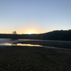
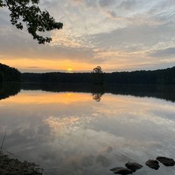
I'm actually a huge fan of this place. This is a beautiful and peaceful trail. I've used this trail for leisurely walks, runs, and on occasion a race. With that said, there are times during the day that they have a lot of bikers, but I look at this as people being out enjoying nature. If you like taking pictures, sunset are also beautiful here. read more

8 years ago
13 years ago
7 years ago
16 years ago
4 years ago
19 years ago
15 years ago
10 years ago
Best trail ever . Done it 3 times , my third time I tried to go as far as possible . # be aware of bikers diareah read more


9 years ago
I loved this trail. I parked at marvel road and ran both directions. If you are looking for a peaceful run, I recommend going right out of the parking lot. If you go left you'll mainly be on sidewalks near cars but nicely paved. I felt very comfortable running alone on this trail. I would love to check it out further on bike. read more


I ride the Rockmart to Cedartown segment frequently. It's about 15 miles and has very little trail traffic. It's pretty challenging ride, don't expect 3% grade, it's easily surpasses that. If you want a ride that will test you, give it a go. I put in @ Nathan Dean Park in Rockmart , plenty of parking and is a safe area. There is a camping site 1/2 way as well. read more


More info about Silver Comet Trail
Mavell Rd
Smyrna, GA 30080
Directions
Visit Website
http://www.silvercometga.com
Hours
Indoor Amenities
Outdoor Amenities
Ask the Community - Silver Comet Trail
I saw a few years ago there were plenty of crimes. Does anyone know about the safety nowadays? I'd like to ride my bike but as a female I'm worried about being alone.
I wouldn't ride alone at night but during the daytime there are ALOT of people out. If you stay in the main trail I wouldn't worry about crime too much.
Taking grandsons for a day to walk, run, explore and picnic. Looks like it has picnic tables and at least one bathroom area. Are the restrooms near the entrance area near Atlanta?
There are a few bathroom facilities along the trail, each located at the trailheads labeled on the official map for the trail. There are also picnic tables at all of the bathroom locations, some have playgrounds, and there are still other locations… Read more
Review Highlights - Silver Comet Trail
You might also consider


Why does Yelp recommend reviews?
13 reviews that are not currently recommended
The reviews below are not factored into the business's overall star rating.
1 year ago
14 years ago
11 years ago
11 years ago
15 years ago
14 years ago
10 years ago
10 years ago
11 years ago
4 years ago
16 years ago
15 years ago
17 years ago
Silver Comet Trail - parks - Updated May 2026
Best of Smyrna
People found Silver Comet Trail by searching for…
Trending Searches in Smyrna, GA
Baseball Fields near Silver Comet Trail
Botanical Gardens near Silver Comet Trail
Bounce House Rentals near Silver Comet Trail
Campgrounds near Silver Comet Trail
Cheap Plants near Silver Comet Trail
Cherry Picking near Silver Comet Trail
Cliff Jumping near Silver Comet Trail
Dog Friendly Trails near Silver Comet Trail
Fishing Ponds near Silver Comet Trail
Flower Shop near Silver Comet Trail
Free Picnic Areas near Silver Comet Trail
Garage Sales near Silver Comet Trail
Garden Center near Silver Comet Trail
Hiking near Silver Comet Trail
Lookout Points near Silver Comet Trail
Nurseries & Gardening near Silver Comet Trail
Off Leash Dog Parks near Silver Comet Trail
Outdoor Activities near Silver Comet Trail
Outdoor Basketball Courts near Silver Comet Trail
Outdoor Furniture Stores near Silver Comet Trail
Parks For Parties near Silver Comet Trail
Party Equipment Rentals near Silver Comet Trail
Pedicure near Silver Comet Trail
Photo Spots near Silver Comet Trail
Picnic Areas near Silver Comet Trail
Places To Take Pictures For Prom near Silver Comet Trail
Public Running Track near Silver Comet Trail
Rock Quarry near Silver Comet Trail
Rv Rental near Silver Comet Trail
Scenic Night View near Silver Comet Trail
Secluded Spots near Silver Comet Trail
Spray Tanning near Silver Comet Trail
Star Gazing near Silver Comet Trail
Swimming Holes near Silver Comet Trail
Table And Chair Rentals near Silver Comet Trail
Tennis Courts near Silver Comet Trail
Walking Trails near Silver Comet Trail
Browse Nearby
BEST of Smyrna, Georgia Coffee near Silver Comet Trail
BEST of Smyrna, Georgia Restaurants near Silver Comet Trail
BEST of Smyrna, Georgia Things to Do near Silver Comet Trail
BEST of Smyrna, Georgia Playgrounds near Silver Comet Trail
BEST of Smyrna, Georgia Breakfast near Silver Comet Trail
BEST of Smyrna, Georgia Picnic Areas near Silver Comet Trail
BEST of Smyrna, Georgia Campgrounds near Silver Comet Trail
BEST of Smyrna, Georgia Limo Service near Silver Comet Trail
Browse Brands
Related Searches in Smyrna, GA
Affordable Bike Repair Services in Smyrna, Georgia
Affordable Kayak Rental Services in Smyrna, Georgia
Affordable Road Bike Rental in Smyrna, Georgia
Affordable Tandem Bike Rental in Smyrna, Georgia
Best Dog Hiking Trails Around Smyrna, Georgia
Best Electric Bike Rental Services in Smyrna, Georgia
Best Fishing Locations and Guides in Smyrna, Georgia
Best Nature Trails for Hiking in Smyrna, Georgia
Best Off Leash Dog Parks in Smyrna, Georgia
Best Parks for Parties and Events in Smyrna, Georgia
Best Places for Horseback Riding in Smyrna, Georgia
Best Used Bikes for Sale Near Smyrna, Georgia
Best Water Parks for Kids in Smyrna, Georgia
Check Out Great Playgrounds in Smyrna, Georgia
Check Out Off Road Trails in Smyrna, Georgia
Discover Baseball Fields Around Smyrna, Georgia
Discover Beautiful Garden Spots in Smyrna, Georgia
Discover Dog Friendly Trails to Explore in Smyrna, Georgia
Discover Free Parking Options in Smyrna, Georgia
Discover Fun Toddler Parks in Smyrna, Georgia for Your Little One
Discover Lakes & Ponds to Explore in Smyrna, Georgia
Discover Popular Bike Tours in Smyrna, Georgia
Discover Popular Bike Trails in Smyrna, Georgia
Discover Popular Photo Spots in Smyrna, Georgia
Discover Scenic Mountain Bike Trails Near Smyrna, Georgia
Discover Soccer Fields in Smyrna, Georgia Near You
Discover Top Nature Parks to Visit in Smyrna, Georgia
Discover Top State Parks to Visit in Smyrna, Georgia
Discover the Best Beaches in Smyrna, Georgia
Discover the Best Night Hike Trails in Smyrna, Georgia
Enjoy Biking Adventures Around Smyrna, Georgia
Enjoy Hiking Adventures in Smyrna, Georgia
Enjoy a Beautiful Waterfall Hike in Smyrna, Georgia
Enjoy the Best Tubing Experiences in Smyrna, Georgia
Enjoy the Best Walking Trails in Smyrna, Georgia
Explore BMX Bike Shops Near Smyrna, Georgia
Explore Beautiful Botanical Gardens in Smyrna, Georgia
Explore Beautiful Parks and Green Spaces in Smyrna, Georgia
Explore Bike Rentals Throughout Smyrna, Georgia
Explore Easy Hikes Perfect for All in Smyrna, Georgia
Explore Electric Bikes Available in Smyrna, Georgia
Explore Family-Friendly Zoos and Wildlife in Smyrna, Georgia
Explore Free Picnic Areas Around Smyrna, Georgia
Explore Fun Activities to Do in Smyrna, Georgia
Explore Parks With Pull Up Bars in Smyrna, Georgia
Explore Popular Campgrounds Near Smyrna, Georgia
Explore Popular Picnic Areas Around Smyrna, Georgia
Explore Popular RV Parks Around Smyrna, Georgia
Browse Articles
People who viewed Silver Comet Trail also viewed
Rottenwood Creek Trail
12 reviews
Heritage Park
12 reviews
Chattahoochee River National Recreation Area - East Palisades
72 reviews
Chattahoochee River National Recreation Area West Palisades
11 reviews
Chattahoochee River Nation Recreation Area
10 reviews
Allatoona Creek Park
3 reviews
Chattahoochee River National Recreation Area Gold Branch
18 reviews
Noonday Creek Trail
9 reviews
Whitewater Creek Trail
39 reviews
Buckhead
Chattahoochee River National Recreation Area
60 reviews