Schafer State Park Photos


You might also consider
More like Schafer State Park
Recommended Reviews - Schafer State Park
Start your review...

1 year ago
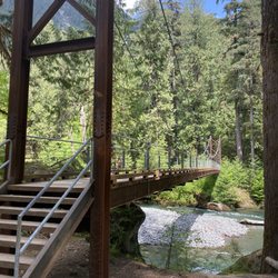
We stayed and camped here for 4 nights total leading up to the 4th of July. The park was mostly empty when we were there and overall was not too noisy. Most of the noise were children playing around during the day but most got very quiet once dark. The park is nice and well kept, this is a newer section that I stayed at. They do have an older side that is a bit more rugged and off grid. The new side spots have power and water. They do provide a sewer dump station which is out off the street. The power hookups had both 30 and 50 amp and it had 2 normal 120 plugs which is what I used to run things. Most of the sites are decent size, not all of them are leveled though, the one I was in was a bit steep and the one next to me even steeper and they had a trailer they had to fight to level. Some of the sites are easy pull thrus but only a few. I noticed at least one ADA site that also has concrete around the pit for those with disabilities. They also had several first come first serve sites. The new side also has a brand new bathroom which is pretty nice and it has multiple bathrooms multiple showers available all newer and upgraded. I am missing those as I am in the grayland state park now where nothing is very new and there seems to always be a line to use one of 2 toilets in the loop. The park is along the river and you can get to it very easy with a couple of trails they have. There is also a trail you can enjoy that goes along the river between it and the campground that is very green. As for staying connected to the world at this park.... you cant unless you bring Starlink, I was able to get pretty decent speeds with my starlink but it can be a challenge depending which site you get and how many trees are in line of site. I was in 2 different sites during my stay and one was easier than the other. None of the cellular networks were working from what I was able to see, T-Mobile was a dud for sure with SOS the whole time, the park wifi allows you to load a page or two for checkin but nothing other than that if you can even get it to connect. Overall it was a pleasant stay and a campground I would possibly consider again in the future. Its a bit more remote for those who need to be connected. read more


2 years ago
Clean restrooms and plenty of water faucets with camp ground areas. Park staff was courteous and helpful. Unfortunately the weather did not cooperate but we enjoyed our four day visit. The adjoining stream was refreshing. Would recommend! read more
3 years ago
4 years ago
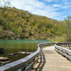
This area would probably be great for grillin' and chillin'. A lot of the parking lot was closed due to the off-season, I guess and the public restrooms were closed as well. The area is really muddy too, so watch your shoes and tires. It is also close to a very rapidly moving river with no fence, so really watch your kids next to the water. Seriously! I'm actually quite surprised that there wasn't any flooding since the water is so close but I went on the rare Washington day that it wasn't rainy. The water is super crystal clear though. It would probably be good for minor wading in the water or if you have strong legs or are an avid swimmer, good for swimming. You do need the discovery pass for this park but they do have a pay per day use station just as you enter the park. It was very nice to drive through and there is a "ranger" station type thing in the park too in case you need information about the park. read more


13 years ago
8 years ago
11 years ago
10 years ago
12 years ago
12 years ago
More info about Schafer State Park
1365 W Schafer Rd
Elma, WA 98541
Directions
Hours
Outdoor Amenities
Other Amenities
Ask the Community - Schafer State Park
Review Highlights - Schafer State Park


Schafer State Park - parks - Updated June 2026
Best of Elma
People found Schafer State Park by searching for…
Things to Do in Elma, Washington
River Swimming in Elma, Washington
Public Shower in Elma, Washington
Hiking Trails in Elma, Washington
Scenic Drive in Elma, Washington
Swimming Lakes in Elma, Washington
Camping Sites in Elma, Washington
Parks for Kids in Elma, Washington
Tent Camping in Elma, Washington
Walking Trails in Elma, Washington
Fishing Spots in Elma, Washington
Water Parks in Elma, Washington
Secret Spots in Elma, Washington
Playgrounds in Elma, Washington
Photo Spots in Elma, Washington
River Tubing in Elma, Washington
Dog Friendly Things to Do in Elma, Washington
Things to See in Elma, Washington
Trending Searches in Elma, WA
Baseball Fields near Schafer State Park
Black Owned Nail Salons near Schafer State Park
Boardwalk near Schafer State Park
Boat Rental near Schafer State Park
Cabins near Schafer State Park
Cliff Jumping near Schafer State Park
Crabbing Location near Schafer State Park
Day Trips near Schafer State Park
Dog Friendly Beaches near Schafer State Park
Fishing Spots near Schafer State Park
Free Picnic Areas near Schafer State Park
Jet Ski Rental near Schafer State Park
Kayak Rental near Schafer State Park
Kids Activities Outdoor near Schafer State Park
Long Term Rv Parking near Schafer State Park
Outdoor Basketball Courts near Schafer State Park
Paddle Boat Rentals near Schafer State Park
Picnic Spots near Schafer State Park
Public Beaches near Schafer State Park
Public Pools near Schafer State Park
Public Shower near Schafer State Park
River Swimming near Schafer State Park
Rv Campgrounds near Schafer State Park
Scenic Overlook near Schafer State Park
Soccer Store near Schafer State Park
Splash Pad near Schafer State Park
Strawberry Picking near Schafer State Park
Sunrise View near Schafer State Park
Swimming Holes near Schafer State Park
Swimming Lakes near Schafer State Park
U Pick Farms near Schafer State Park
Browse Nearby
Browse Brands
Related Cost Guides
Related Searches in Elma, WA
Affordable Jet Ski Rental Options in Elma, Washington
Affordable Kayak Rental Services in Elma, Washington
Affordable Long Term RV Parking in Elma, Washington
Best Day Camps for Children in Elma, Washington
Best Fun Things to Do in Elma, Washington
Best Off Leash Dog Parks in Elma, Washington
Best Pontoon Boat Rentals Near Elma, Washington
Best Waterfalls and Swimming Holes in Elma, Washington
Browse Top Hotels in Elma, Washington for Your Stay
Browse Vacation Rentals to Book in Elma, Washington
Check Out Great Playgrounds in Elma, Washington
Discover Baseball Fields Around Elma, Washington
Discover Dog Friendly Beaches Near Elma, Washington
Discover Lakes & Ponds to Explore in Elma, Washington
Discover Popular Photo Spots in Elma, Washington
Discover Scenic Beach Camping Sites in Elma, Washington
Discover Top Boat Tours in Elma, Washington for All Ages
Discover Top State Parks to Visit in Elma, Washington
Discover the Best Beaches in Elma, Washington
Discover the Best Kids Park Spots in Elma, Washington
Discover the Best Night Hike Trails in Elma, Washington
Enjoy Hiking Adventures in Elma, Washington
Enjoy Kayaking Adventures in Elma, Washington
Enjoy River Tubing Adventures in Elma, Washington
Enjoy the Best Walking Path in Elma, Washington
Explore Beautiful Parks and Green Spaces in Elma, Washington
Explore Fun Activities to Do in Elma, Washington
Explore Landmarks & Historical Buildings in Elma, Washington
Explore Mobile Home Parks in Elma, Washington Now
Explore Pickleball Courts in Elma, Washington
Explore Popular Campgrounds Near Elma, Washington
Explore Popular RV Parks Around Elma, Washington
Explore Popular Recreation Centers Around Elma, Washington
Explore Popular Scenic Views Near Elma, Washington
Explore Popular View Points Around Elma, Washington
Explore Scenic Lakes to Visit in Elma, Washington
Explore Summer Camps for All Ages in Elma, Washington
Explore Top Dog Parks in Elma, Washington Near You
Explore Top Gyms in Elma, Washington Now
Explore Top Water Parks in Elma, Washington Today
Explore the Best Swimming Holes Around Elma, Washington
Explore the Best Trail Options in Elma, Washington
Find Beautiful Views in Elma, Washington
Find Cozy Camping Cabins in Elma, Washington
Find Top Skate Parks in Elma, Washington for All Skill Levels
Find Top-Rated Waterfalls in Elma, Washington Now
Find a Park With BBQ Pits in Elma, Washington
Find the Best Parks for Picnics in Elma, Washington
Browse Articles
People who viewed Schafer State Park also viewed
Lake Sylvia State Park
22 reviews
Friends Landing
24 reviews
Stewart's Memorial Park
3 reviews
Kneeland Park
2 reviews
North End Playfield
1 review
Art Pocklington Central Play Park
2 reviews
Overlook Park
1 review
Vance Creek Railriders
21 reviews
Grays Harbor Visitor Information Center
1 review
Skydive Kapowsin
86 reviews