1. SC Historical Marker

0

Manning, SC

Cancel

Open app

Search

SC Historical Marker Photos

Recommended Reviews - SC Historical Marker

Your trust is our priority, so businesses can't pay to alter or remove their reviews. Learn more about reviews.
Yelp app icon
Browse more easily on the app
Review Feed Illustration
Photo of Bruce K.
2442
26475
79066

2 years ago

Helpful 7
Thanks 0
Love this 3
Oh no 0

Verify this business for free

Get access to customer & competitor insights.

Verify this business

Hampton Plantation Historic Site

Hampton Plantation Historic Site

4.6(22 reviews)
56.2 mi

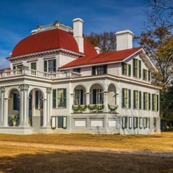
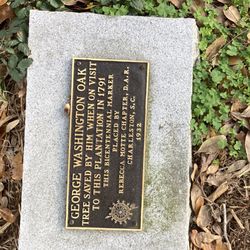
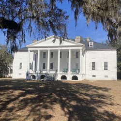
We knew we would only have time for one plantation experience on this trip two years ago and only a…read moremorning or afternoon to tour. If you are looking for something totally different yet satisfying and educational, you'll definitely enjoy Hampton Plantation State Historic Site in McClellanville, S.C., on the Wambaw Creek in the Santee Delta. The Colonial-era rice plantation mansion on 274 acres with its remnant buildings, two cemeteries, trails, three endangered species and park buildings holds a quiet change of pace from other Charleston area attractions. "Tours include a study of the architecture and evolution of the house, as seen in the open walls and unfurnished rooms, as well as personal insight into the people that called Hampton home." Built in the 1740's, two wings were added in 1760 and the first Adams style portico in the Lowcountry was added in 1791. The structures at the once 700 acre prosperous and bustling Hampton Plantation are architectural monuments to the labor of enslaved Africans. Here at Hampton, "The plantation's Georgian-style mansion and well-kept grounds serve as an interpretive site for the system of slavery that helped build such plantations in South Carolina into the greatest generators of wealth in early American history." "The property also tells the story of the freed people who made their homes in the Santee Delta region for generations after emancipation. Visitors can explore the mansion, wander the plantation grounds or look out upon Wambaw Creek at the remains of rice fields that once stretched as far as the eye could see." During the Revolutionary War, the British captured Charleston. They said that any man bearing arms against them would be treated as a traitor and so they searched houses and plantations, confiscating any valuables, including slaves, not even knowing for certain who were traitors it seems. Hampton was searched twice and plundered of everything. Just think of those soldiers, over 200 years ago, pounding up and down those still solid wooden stairs, hauling off whatever they wanted, including people already sold once, that they were going to sell again, on down the road. After the war, George Washington visited Hampton in 1791. The President was asked whether a certain oak tree should be cut down to create a better view from the newly built portico. He replied that he liked the tree, and it was saved. From then on the tree was known as the Washington Oak. It still stands almost 230 years later! This visit here at a historic place cared for by the Park Service was quite a find and a bargain. Stop here, if you get the chance. The park website below has an incredible virtual tour if you don't get the opportunity to visit this unusual historic plantation in person. Grounds are free. House admission: $7.50/adult; $3.75/S.C. Senior; $3.50/youth age 6-15; Free for children 5 & younger. Ground Hours: Apr. - Oct. 9 a.m.- 6 p.m., daily. Nov. - Mar. 9 a.m.- 5 p.m.  Mansion Hours: Guided tours only, F, M and Tu noon and 2 p.m. Sa-Su 10 a.m., noon and 2 p.m. https://south-carolina-plantations.com/charleston/hampton.html https://southcarolinaparks.com/hampton
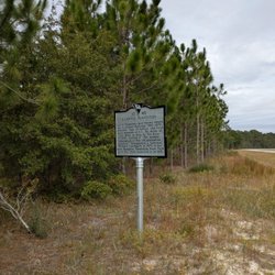
This historical marker along US-17 is in front of the Hampton Plantation Historic site and provides…read morea brief overview of the history. This is old Charleston, dating back to Colonial times, and even in condensed form the place carries more weight than the marker can hold. It notes the Horry and Rutledge families and the plantation's early eighteenth century origins, but it leaves out the deeper story of the rice economy built through the labor and agricultural knowledge of enslaved Africans whose work shaped every field along the Santee. The front of the marker reads, "Hampton Plantation, 2 mi. N.W., was established by 1730 and was one of the earliest rice plantations on the Santee River, in an area settled by Huguenots and often called "French Santee." The house, built in the 1730's for Elias Horry, later passed to his granddaughter Harriott Horry, who married Frederick Rutledge in 1797. The plantation remained in the Rutledge family until 1971." And the reverse, "One of Hampton's best-known owners was Archibald Rutledge (1883-1973), educator, man of letters, and first poet laureate of S.C. He wrote of life there in Home by the River (1941), calling it "the mother plantation of this old plantation country." Designated a National Historic Landmark in 1970, it has been Hampton Plantation State Park since the state acquired it in 1971." The limited space on the marker omits much. Including the near‑loss of the house in the twentieth century and Archibald Rutledge's role in reviving interest, as well as the long‑loved Washington Oak that tradition links to George Washington's 1791 visit. Today the unfurnished house and quiet grounds at Hampton Plantation State Park offer a clearer sense of the layered past than the roadside text suggests, inviting visitors to step beyond the marker and into a landscape where memory, myth, and history still mingle. It is marker number 1040 and it was erected in 2001 by the St. James-Santee Parish Historical Society. [Review 107 of 2026 - 1377 in South Carolina - 25297 overall]

Photos
Hampton Plantation Historic Site - Hampton Plantation Historical Marker, Mc Clellanville

Hampton Plantation Historical Marker, Mc Clellanville

Hampton Plantation Historic Site - Hampton Plantation Historical Marker, Mc Clellanville

Hampton Plantation Historical Marker, Mc Clellanville

Hampton Plantation Historic Site

See all

Cotton Press Historical Marker - Cotton Press Historical Marker, Latta SC

Cotton Press Historical Marker

5.0(3 reviews)
59.4 mi

Located just a quarter mile south of I-95 on South Carolina Highway 38, this marker has a small…read morespace for parking and a view. There is a "historical marker ahead" sign and you shouldn't miss the hulking shape of the machinery it points out. The marker reads, "This cotton press, built in 1798 according to tradition, is thought by many to be the oldest in existence. It was first owned and used by John Bethea, III, and later by Henry Berry. Powered by oxen or mules rotating the beam to tighten the press, it was rendered obsolete by modern machinery. A Berry descendant moved it to this site about 1948 to preserve it." The marker was added to the National Register of Historic Places in 1972. It had been built in 1798 for bailing ginned cotton and is made of pegged and doweled oak. Turning the screw (powered by mules) compressed the cotton into a wooden frame to form a bale. A very clever piece of machinery, all built by hand well prior to modern power tools. Except for minor repairs of the base and roof, it is still the original materials and is the only press of this era in South Carolina. [Review 14328 overall, 1652 of 2020, number 706 in South Carolina.]

This cotton press, built in 1798 according to tradition, is thought by many to be the oldest in…read moreexistence. It was first owned and used by John Bethea, III, and later by Henry Berry. Powered by oxen or mules rotating the beam to tighten the press, it was rendered obsolete by modem machinery. A Berry descendant moved it to this site about 1948 to preserve it. Erected by Dillon County Historical Society - 1974

Photos
Cotton Press Historical Marker - Cotton Press Historical Marker, Latta SC

Cotton Press Historical Marker, Latta SC

Cotton Press Historical Marker - Cotton Press Historical Marker, Latta SC

Cotton Press Historical Marker, Latta SC

Cotton Press Historical Marker

See all

Site of the Surrender of Columbia - This marks the site of the surrender of the city of Columbia. It is a must for Civil War buffs, history buffs, and Carolinians.

Site of the Surrender of Columbia

5.0(2 reviews)
52.9 mi

Site of the surrender of Columbia South Carolina. It is very…read moreclose to downtown, will not take much time to visit, but is an absolute must. An engraved rock marks the location and serves as a remembrance of the occasion of the surrender of the city of Columbia South Carolina. Columbia, a major city in the confederacy and the birthplace of the secession movement, was a strategic target for general Sherman and the Union forces. The succession convention, was the first, and it was the only convention to unanimously vote to leave the Union. Sherman and his troops' desire to exact revenge on the city was deep, according to historical documents. In advance of the Union forces attacked in the city, the Confederate troops burn down the bridges leading to the city on February 16, 1865, under the direction of General Wade Hampton III. Hampton, The grandson of a Revolutionary War hero, and considered a hero in his own right, evacuated his troops and placed the mayor, TJ Goodwyn in charge. Union forces began to shell the city from across the river. Seeing what happened to other cities, and hoping to spare Columbia, he ordered Mayor Goodwyn to surrender the city on the morning of the 17th just north of the city. Between 8 AM and 9 AM, the city's Aldermen and the Mayor surrendered formally to Sherman's troops. Unfortunately, this did not help as Sherman and his troops proceeded to torch the city at night. At least two thirds of the city burned as troops set fire to homes, businesses, schools, municipal buildings, and churches. In 1914, the United daughters of the Confederacy held a dedication ceremony featuring the sole surviving witness, Norton W. Brooker, and six descendants of the mayor. The engraved rock sits in front of the church on the corner of River Road and Beaufort Street in the historic Earlewood neighborhood.

Thanks so much for this valuable information! I've been trying to find the location of the site of…read moreColumbia's surrender. I grew up there and have lived in Charlotte for the last 19 years, but plan to ride by tomorrow! Is there not a marker for the site of Camp Sorghum? I have the general area mapped out but I guess there are no traces left. Thanks again!

Photos
Site of the Surrender of Columbia

See all

SC Historical Marker - landmarks - Updated October 2026

Loading...
Loading...
Loading...