Santiago Peak Photos


You might also consider
More like Santiago Peak
Recommended Reviews - Santiago Peak
Start your review...

Reviews With Photos

I don't know why they just don't permanently close this trail. This is my third time trying to get to the peak and maybe it's my timing or my luck but it's closed again. Now sure, I can check if the road is open through their Cleveland national forest website but that rarely gets updated and if it does, it still states "open but subject to closure due to weather conditions". This peak is in a national forest so fires are common. If there's a fire then it's closed. If it rains then it's closed. Drizzling? Misty? Fog? Slight breeze? A puddle cause a hiker that poured out his water bottle? Closed closed closed closed and closed. If it's anything other then a sunny day then consider it closed. If you come here, make sure you have a plan B or you just wasted time and a lot of gas to look at a white rusty gate. Tip: Burgers around the Tustin/Chapman area are good. Make sure you have a couple of bucks to spare for panhandlers and beggars.

Super hard hike but so beautiful! We went in late (7am) and hiked the main divide. The trail had really nice overview of orange county! There's no cell reception up top which is expected so make sure to pack all the stuff you need. TAKE A LOT OF WATER. JUST WHEN YOU THOUGHT YOU PACKED ENOUGH PACK SOME MORE! Very refreshing and relaxing. Serious leg workout haha. Go early in the morning so u can avoid the heat coming back down. We saw a couple deers on our way up and down. Very fun date idea!

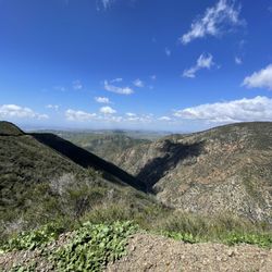
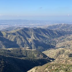
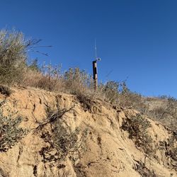
I wanna free fall out into nothin' Gonna leave this world for awhile And I'm free, I'm free fallin' -- Tom Petty, "Free Falling" I live in two worlds right now, Silicon Valley and Orange County. One of the many differences between the two is how easily accessible outstanding hiking is in the Bay Area. Orange County just cannot compare. With one exception: The hike up to Santiago Peak. From Wikipedia: Santiago Peak is the southern mountain of Orange County's Saddleback formation. It is the highest and most prominent peak of both the Santa Ana Mountains and Orange County, and also marks a border point with Riverside County There are a couple of different ways you can do this hike. One is starting at Modjeska Canyon and hiking up the Harding Trail. The other is via the Holy Jim/Main Divide Road which is the way Glenn G. and I did it. There are several different places to park. We chose closest parking lot next to tiny woodsy community that is adjacent to the Holy Jim Trail. For some reason, the Holy Jim Trail head seems a lot closer when you start out then when you return to the car :) To get to this parking lot is a 4.5 slow drive over rugged Trabuco Creek Rd (enter at Trabuco Canyon Rd just south of bridge over the creek) that my dusty Subaru had a good time with. Like the Indiana Jones ride at Disneyland!! You need $5 Adventure Pass at this point. You can park closer to Trabuco Canyon but that does add the road mileage to your hike so plan accordingly. There are essentially 3 legs to the hike we did. The first 5.5 miles is on the Holy Jim Trail. You can stop and look at the Falls but given the compressed light schedule during the winter, we bypassed this part as we did not hit the trail till 8:50 or so. During the winter, an 8:00AM start is probably best option if you want to add the Falls and have lunch on the Peak. The first few miles are relatively easy grade up as you walk in a nice Oak shaded area and pass the Falls. At around the 2 mile mark you leave most of the Canyon growth behind and leave the shade. On our day it was quite lovely and then the views start appearing. Wow!! Almost like a mini-Big Sur. It is rocky at points but the view is so worth it!! At the 5 mile mike you have a choice for the second leg. Go up to peak on Main Divide Road (which is accessible via 4x4 vehicles) or go up the Upper Holy Jim Trail. All my hiking reviews said go up the Holy Jim for better views. So Glenn and I searched and searched for the trail. The sign for the trail is useless as it points to the side of the mountain. But Glenn being intrepid found the trail through some brush and up we went! This is easily the hardest incline of this hike and with a too full backpack (did I really need to bring the spare tire jack?) I admit I struggled at some points on this leg. But the views were as advertised!!! While there is little shade, you get absolutely stunning vistas out towards the ocean and to Lake Elsinore/Corona. Going the Upper Holy Jim trail way creates the third leg as it meets up with the Main Divide Road. At this point you've gone about 7 miles and you still have 1.5 miles of a slog up to the Peak. At this time of the year sometimes there is a lot of snow but on this January hike we just saw remnant patches. The views at this stretch are primarily of the Inland Empire and the mountain peaks to the East. After all this uphill, the Peak might be a letdown as it is full of cell towers and antennas. There are no 360 vistas but walk the complex as you will get stunning views of Orange County and the 909 area code. The downhill portion is not as easy as you might think as it is very rocky and slippery in areas. We thought we could jet downhill but it didn't quite work out that way. You are tired regardless and with the terrain, cannot pick up the speed you'd like. Both Glenn and I took headers at points in the downhill, me near the peak and Glenn as we were closer to the parking lot (hence the Tom Petty lyric to start). My fall was a bit more precarious as my backpack (Did I really need to pack an anvil?) shifted over my head and Glenn had to stabilize it before I could get up lest I take the short route to the Canyon floor. The guides will tell you this is a 16 mile hike but it really is 17 miles when you add in the walk through the cabin neighborhood to get to the trailhead. Like a Stephen King or Sidney Stone horror novel though, the walk from the trailhead back to the car was agonizingly longer then the walk to the trailhead in the morning. It is like the neighborhood expanded during the day ;) In the end though, it was a fantastic hike that all Orange County residents should do at least once! Pack smarter than I did though. I packed too much water, too much food, unneeded binoculars that were used for 5 seconds. The pack was an albatross during the second leg steepness and a damn heavy albatross during the downhill home. My shoulders hate me right now

This is an absolutely beautiful hike. It is so green! I commend the caretaker of the trail because there is a cart filled with packages of free water and a trash bag prior to entering at the trail head. There's a stream you pass by a few times down at the bottom of the mountain. You immediately start to ascent once past the waterfall fork. Most of the trail is at the edge of the mountain with incredible views. This is a tough hike but I would say it's a little less than Mt. Wilson. We were so happy because we got to see a little snow towards the peak. The peak, at 5687', is right in the clouds so it does get a little cold. Altogether, we hiked roughly 17.1 miles: We didn't have enough time to do the entire loop so we back tracked. This is an excellent hike to train for Mt. Baldy. Also, down at the bottom waterfall fork, the trail splits where you can hike about a mile to see the falls in the area. I would love to come back to see it sometime on a lighter adventure :)

Santiago Peak and the Holy Jim Trail that takes you to it gives you a great taste of Orange County backcountry! Getting here can be a rough ride if you don't have the right vehicle. There is a parking area (adventure pass required) at the bottom of a little residential community within the Cleveland National Forest before the trailhead to the Holy Jim Falls. I have always skipped that area and driven up the one lane semi-private road as there are several unoccupied properties by the trailhead where you can park. So far I haven't had any problems parking there, knock on wood! As for the hike, it isn't for the feint of heart as it is a strenuous journey to the top of OC, almost 16 miles roundtrip. While I've made it to the top more often than not a few times we had to turn back, whether it be for too little water over the summer or the freezing rain drenching us to the point of misery. You definitely want to pick the right time of the year to go and it's better with a group than solo. After my experiences I'd skip a summer hike as there is very little tree cover, despite the mountain looking all green from afar! The hike is more about the exercise and getting in tune with nature than the views, as even at the top they aren't the greatest. Oh, and on rare occasions it's about the chance to experience snow in Orange County! If you make it to the top you'll be beat after the hike so it's best to enjoy your accomplishment with a cold one from Cook's Corner on the way back!

Don't underestimate how long it takes to hike to the peak. We didn't make it because of that lol. We started the hike at 1pm, and ended at 6:30pm, so about 3 hours of nonstop hiking until we hit our turnaround point at 5pm. It would have gotten dark if we kept going, but yeah, have a good amount of time. I WENT UP TO JIM CROW IN A 2WHEEL DRIVE CAMRY. Don't do this, trust the people who say you need a high clearance car or you can hear the terrain and bumps hit the bottom of your car. We went super slow to get up... Slower than walking speed, while other cars floored through it like nothing. Don't bend or break and axle. The entire hike we did was ~16 miles round trip. Completely worth it and pretty hard so being fit definitely helps.

Great mountain to hike. I've done it a few times, and normally drink my 3L camel pack water plus a couple more small bottles of water. Make sure you load up on carbs before and while your hiking, I'm talking about dried fruit, granola bars etc. I always get an early start when hiking a trail this long. There are mountain lions and coyotes in the Cleveland national forest, so walking back in the dark isn't the best idea. So, start in the morning, bring lots of water, snacks that give you energy, sunscreen, a hat and sunglasses, tick/mosquito spray and for emergency purposes, bring a lighter(use your head, don't be a dumbass) and atleast a knife.

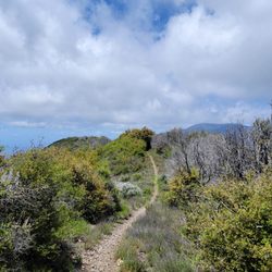
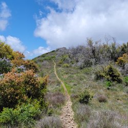
For a local peak trail that only tops off at 5,689 feet at Santiago Peak, this was not an easy hike at all! This Holy Jim Trail covers 15.6 miles round trip with 4,000 feet of elevation gain. If it wasn't for the long 4.6 miles of ROUGH dirt road just to get to the trail head, this would be a good local hike for Orange County's highest peak. But for me, there are better trails near by to summit a peak, without the wear and tear on your vehicle. It took me 30 minutes to drive that 4.6 miles. I would rather hike Mt Baldy, San Jacinto, San Gorgonio or the forgotten San Bernardino Peaks. From the Santa Ana Freeway, exit El Toro Road and head east. When you reach Cook's Corner, turn right on Live Oak Canyon Road and drive 4.3 miles. As soon as you pass O'Neil Park look for Rose Street. At Rose Street there is a wash. Immediately after the wash, turn left onto the dirt Trabuco Creek Road. Stay straight on this rough dirt road for 4.6 miles to the parking lot. A parking Adventure Pass is required here. http://www.yelp.com/biz_photos/holy-jim-falls-trail-trabuco-canyon?select=ahR4SfFGNX3tbw9oT6Nf-Q&utm_campaign=www_photo_share_popup&utm_medium=copy_link&utm_source=(direct) Cars can travel this road, but having a high clearance vehicle is better. Some of the holes are deep. http://www.yelp.com/biz_photos/holy-jim-falls-trail-trabuco-canyon?select=C5-LOnu1gvWUUHvyp6VXcw&utm_campaign=www_photo_share_popup&utm_medium=copy_link&utm_source=(direct) From the parking lot, walk up the dirt road to the left behind the trailhead sign. You quickly pass by some cabins and in 0.5 miles you will reach the actual trailhead. This trail is very well maintained and easy to follow. On the upper section, you will need to know where to turn for the smaller trail junctions. There are a few nice water creeks to cross, but there are boulders and tree logs in place. Once you pass the junction to the falls, the trail gets steeper as it switchbacks up the mountain. After about 2 miles the trail is a hedge grove tunnel. In this section, your view is hidden. I like the upper two thirds of the trail, where the views are nice and you start to feel like you are on a mountain. The last 1.5 miles you follow a rocky dirt service road to the summit, which I wasn't too fond of. But the summit was very interesting with all those antennas. On the way down, I stopped off at the falls, which adds only 0.4 miles round trip. I like using landmarks to break up a long hike into smaller sections: * Trailhead - 1,740' elevation * 0.5 miles - Actual trailhead * 1.4 miles - Holy Jim Falls junction sign. (2,285') Go Left to towards Santiago Peak, or Go Right 0.2 miles to the falls. * 3.5 miles - 3 mile marker * 4.5 miles - 4 mile marker (3,835') * 4.85 miles - Climb up to the lower Main Divide Rd Go Right * 4.88 miles - Bear Springs concrete vault. Continue on the road to the right. * 5.25 miles - Take a sharp Left turn up the narrow steep path almost hidden by bushes. There will be 2nd 'Upper Holy Jim' white sign here. (4,050') http://www.yelp.com/biz_photos/holy-jim-falls-trail-trabuco-canyon?select=1Haz1badkf8dsCmiTlAsMQ&utm_campaign=www_photo_share_popup&utm_medium=copy_link&utm_source=(direct) * 6.14 miles - Reach the upper Main Divide Road U-turn. Go Right & wrap around to the Left & head towards the antennas. * 7.6 miles - Santiago Peak where the antennas are. 5,689' Don't get me wrong, I liked this trail, but with all the considerations it wasn't my favorite mountain hike. However, this trail is perfect for a FAST descent.

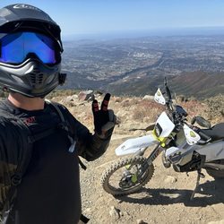
Entering from Silverado Canyon Rd to Maple Springs Truck Trail , connecting to Main Divide Rd, all the way up to Santiago Peak and all the way down Main Divide Rd to the Ortega Hwy (route 74) is 25-30 miles or so. Or you can take the Indian Truck Trail Rd down and end up at the 15. Make sure to check their website to see if the "Maple Springs Road" gate is open before you go: http://www.fs.usda.gov/detailfull/cleveland/alerts-notices/?cid=stelprdb5340229&width=full Awesome trails for dual-sports and high clearance vehicles with some breathtaking views. 4x4 isn't necessarily needed, but you should definitely have some decent all-terrain tires, especially since it can get icy up there. I've never had issues in my 2wd 4runner, but I have some aggressive tires and a low gear. I suggest being confident in your maneuvering skills because it gets very tight in spots, leaving very little room for error. When there's not enough room to pass a vehicle coming in the oppose direction, either you or the other vehicle has to reverse until there's enough room to pass, basically leaving your tires only inches from the edge. Be careful of the dual-sports flying around corners.

ADVICE: make sure to lower down your tire pressure - you can get stuck and ruin your car. This was awesome for Off-roading! We had a caravan of 4 cars: 2 Rivian's and 2 4Runners. Was an easy drive and wasn't too challenging, only at the very end it can be tricky. But if you want to see the view, park your car and walk if you don't feel your car can take the trail. read more


3 years ago
Large park with many trails of different difficulty levels. $3.00 for weekdays. $5.00 for weekends. They have a small but nice nature center. There are alot of cyclists/bikers at this park, so be careful. The best views require some steep climbing but well worth it. There is an array of flora and fauna here. Wildlife I saw were lizards, beetles, birds, coyote, and mule deer. I recommend going on a trail but coming back on a different one so you can see different parts of the park. Also, if you like history there are informational displays to inform you about the people and changes this area went through. Due to the damage of the natural habitat over the years, there appears to be a large effort to restore it so please stay on the trails. This was a wonderful park so if you are a hiker who loves nature, this park is for you. Enjoy! read more
4 years ago
I don't know why they just don't permanently close this trail. This is my third time trying to get to the peak and maybe it's my timing or my luck but it's closed again. Now sure, I can check if the road is open through their Cleveland national forest website but that rarely gets updated and if it does, it still states "open but subject to closure due to weather conditions". This peak is in a national forest so fires are common. If there's a fire then it's closed. If it rains then it's closed. Drizzling? Misty? Fog? Slight breeze? A puddle cause a hiker that poured out his water bottle? Closed closed closed closed and closed. If it's anything other then a sunny day then consider it closed. If you come here, make sure you have a plan B or you just wasted time and a lot of gas to look at a white rusty gate. Tip: Burgers around the Tustin/Chapman area are good. Make sure you have a couple of bucks to spare for panhandlers and beggars. read more

3 years ago
5 years ago
Super hard hike but so beautiful! We went in late (7am) and hiked the main divide. The trail had really nice overview of orange county! There's no cell reception up top which is expected so make sure to pack all the stuff you need. TAKE A LOT OF WATER. JUST WHEN YOU THOUGHT YOU PACKED ENOUGH PACK SOME MORE! Very refreshing and relaxing. Serious leg workout haha. Go early in the morning so u can avoid the heat coming back down. We saw a couple deers on our way up and down. Very fun date idea! read more


I wanna free fall out into nothin' Gonna leave this world for awhile And I'm free, I'm free fallin' -- Tom Petty, "Free Falling" I live in two worlds right now, Silicon Valley and Orange County. One of the many differences between the two is how easily accessible outstanding hiking is in the Bay Area. Orange County just cannot compare. With one exception: The hike up to Santiago Peak. From Wikipedia: Santiago Peak is the southern mountain of Orange County's Saddleback formation. It is the highest and most prominent peak of both the Santa Ana Mountains and Orange County, and also marks a border point with Riverside County There are a couple of different ways you can do this hike. One is starting at Modjeska Canyon and hiking up the Harding Trail. The other is via the Holy Jim/Main Divide Road which is the way Glenn G. and I did it. There are several different places to park. We chose closest parking lot next to tiny woodsy community that is adjacent to the Holy Jim Trail. For some reason, the Holy Jim Trail head seems a lot closer when you start out then when you return to the car :) To get to this parking lot is a 4.5 slow drive over rugged Trabuco Creek Rd (enter at Trabuco Canyon Rd just south of bridge over the creek) that my dusty Subaru had a good time with. Like the Indiana Jones ride at Disneyland!! You need $5 Adventure Pass at this point. You can park closer to Trabuco Canyon but that does add the road mileage to your hike so plan accordingly. There are essentially 3 legs to the hike we did. The first 5.5 miles is on the Holy Jim Trail. You can stop and look at the Falls but given the compressed light schedule during the winter, we bypassed this part as we did not hit the trail till 8:50 or so. During the winter, an 8:00AM start is probably best option if you want to add the Falls and have lunch on the Peak. The first few miles are relatively easy grade up as you walk in a nice Oak shaded area and pass the Falls. At around the 2 mile mark you leave most of the Canyon growth behind and leave the shade. On our day it was quite lovely and then the views start appearing. Wow!! Almost like a mini-Big Sur. It is rocky at points but the view is so worth it!! At the 5 mile mike you have a choice for the second leg. Go up to peak on Main Divide Road (which is accessible via 4x4 vehicles) or go up the Upper Holy Jim Trail. All my hiking reviews said go up the Holy Jim for better views. So Glenn and I searched and searched for the trail. The sign for the trail is useless as it points to the side of the mountain. But Glenn being intrepid found the trail through some brush and up we went! This is easily the hardest incline of this hike and with a too full backpack (did I really need to bring the spare tire jack?) I admit I struggled at some points on this leg. But the views were as advertised!!! While there is little shade, you get absolutely stunning vistas out towards the ocean and to Lake Elsinore/Corona. Going the Upper Holy Jim trail way creates the third leg as it meets up with the Main Divide Road. At this point you've gone about 7 miles and you still have 1.5 miles of a slog up to the Peak. At this time of the year sometimes there is a lot of snow but on this January hike we just saw remnant patches. The views at this stretch are primarily of the Inland Empire and the mountain peaks to the East. After all this uphill, the Peak might be a letdown as it is full of cell towers and antennas. There are no 360 vistas but walk the complex as you will get stunning views of Orange County and the 909 area code. The downhill portion is not as easy as you might think as it is very rocky and slippery in areas. We thought we could jet downhill but it didn't quite work out that way. You are tired regardless and with the terrain, cannot pick up the speed you'd like. Both Glenn and I took headers at points in the downhill, me near the peak and Glenn as we were closer to the parking lot (hence the Tom Petty lyric to start). My fall was a bit more precarious as my backpack (Did I really need to pack an anvil?) shifted over my head and Glenn had to stabilize it before I could get up lest I take the short route to the Canyon floor. The guides will tell you this is a 16 mile hike but it really is 17 miles when you add in the walk through the cabin neighborhood to get to the trailhead. Like a Stephen King or Sidney Stone horror novel though, the walk from the trailhead back to the car was agonizingly longer then the walk to the trailhead in the morning. It is like the neighborhood expanded during the day ;) In the end though, it was a fantastic hike that all Orange County residents should do at least once! Pack smarter than I did though. I packed too much water, too much food, unneeded binoculars that were used for 5 seconds. The pack was an albatross during the second leg steepness and a damn heavy albatross during the downhill home. My shoulders hate me right now read more


This is an absolutely beautiful hike. It is so green! I commend the caretaker of the trail because there is a cart filled with packages of free water and a trash bag prior to entering at the trail head. There's a stream you pass by a few times down at the bottom of the mountain. You immediately start to ascent once past the waterfall fork. Most of the trail is at the edge of the mountain with incredible views. This is a tough hike but I would say it's a little less than Mt. Wilson. We were so happy because we got to see a little snow towards the peak. The peak, at 5687', is right in the clouds so it does get a little cold. Altogether, we hiked roughly 17.1 miles: We didn't have enough time to do the entire loop so we back tracked. This is an excellent hike to train for Mt. Baldy. Also, down at the bottom waterfall fork, the trail splits where you can hike about a mile to see the falls in the area. I would love to come back to see it sometime on a lighter adventure :) read more


3 years ago
Santiago Peak and the Holy Jim Trail that takes you to it gives you a great taste of Orange County backcountry! Getting here can be a rough ride if you don't have the right vehicle. There is a parking area (adventure pass required) at the bottom of a little residential community within the Cleveland National Forest before the trailhead to the Holy Jim Falls. I have always skipped that area and driven up the one lane semi-private road as there are several unoccupied properties by the trailhead where you can park. So far I haven't had any problems parking there, knock on wood! As for the hike, it isn't for the feint of heart as it is a strenuous journey to the top of OC, almost 16 miles roundtrip. While I've made it to the top more often than not a few times we had to turn back, whether it be for too little water over the summer or the freezing rain drenching us to the point of misery. You definitely want to pick the right time of the year to go and it's better with a group than solo. After my experiences I'd skip a summer hike as there is very little tree cover, despite the mountain looking all green from afar! The hike is more about the exercise and getting in tune with nature than the views, as even at the top they aren't the greatest. Oh, and on rare occasions it's about the chance to experience snow in Orange County! If you make it to the top you'll be beat after the hike so it's best to enjoy your accomplishment with a cold one from Cook's Corner on the way back! read more


11 years ago
Don't underestimate how long it takes to hike to the peak. We didn't make it because of that lol. We started the hike at 1pm, and ended at 6:30pm, so about 3 hours of nonstop hiking until we hit our turnaround point at 5pm. It would have gotten dark if we kept going, but yeah, have a good amount of time. I WENT UP TO JIM CROW IN A 2WHEEL DRIVE CAMRY. Don't do this, trust the people who say you need a high clearance car or you can hear the terrain and bumps hit the bottom of your car. We went super slow to get up... Slower than walking speed, while other cars floored through it like nothing. Don't bend or break and axle. The entire hike we did was ~16 miles round trip. Completely worth it and pretty hard so being fit definitely helps. read more

4 years ago
11 years ago
Great mountain to hike. I've done it a few times, and normally drink my 3L camel pack water plus a couple more small bottles of water. Make sure you load up on carbs before and while your hiking, I'm talking about dried fruit, granola bars etc. I always get an early start when hiking a trail this long. There are mountain lions and coyotes in the Cleveland national forest, so walking back in the dark isn't the best idea. So, start in the morning, bring lots of water, snacks that give you energy, sunscreen, a hat and sunglasses, tick/mosquito spray and for emergency purposes, bring a lighter(use your head, don't be a dumbass) and atleast a knife. read more


4 years ago
For a local peak trail that only tops off at 5,689 feet at Santiago Peak, this was not an easy hike at all! This Holy Jim Trail covers 15.6 miles round trip with 4,000 feet of elevation gain. If it wasn't for the long 4.6 miles of ROUGH dirt road just to get to the trail head, this would be a good local hike for Orange County's highest peak. But for me, there are better trails near by to summit a peak, without the wear and tear on your vehicle. It took me 30 minutes to drive that 4.6 miles. I would rather hike Mt Baldy, San Jacinto, San Gorgonio or the forgotten San Bernardino Peaks. From the Santa Ana Freeway, exit El Toro Road and head east. When you reach Cook's Corner, turn right on Live Oak Canyon Road and drive 4.3 miles. As soon as you pass O'Neil Park look for Rose Street. At Rose Street there is a wash. Immediately after the wash, turn left onto the dirt Trabuco Creek Road. Stay straight on this rough dirt road for 4.6 miles to the parking lot. A parking Adventure Pass is required here. http://www.yelp.com/biz_photos/holy-jim-falls-trail-trabuco-canyon?select=ahR4SfFGNX3tbw9oT6Nf-Q&utm_campaign=www_photo_share_popup&utm_medium=copy_link&utm_source=(direct) Cars can travel this road, but having a high clearance vehicle is better. Some of the holes are deep. http://www.yelp.com/biz_photos/holy-jim-falls-trail-trabuco-canyon?select=C5-LOnu1gvWUUHvyp6VXcw&utm_campaign=www_photo_share_popup&utm_medium=copy_link&utm_source=(direct) From the parking lot, walk up the dirt road to the left behind the trailhead sign. You quickly pass by some cabins and in 0.5 miles you will reach the actual trailhead. This trail is very well maintained and easy to follow. On the upper section, you will need to know where to turn for the smaller trail junctions. There are a few nice water creeks to cross, but there are boulders and tree logs in place. Once you pass the junction to the falls, the trail gets steeper as it switchbacks up the mountain. After about 2 miles the trail is a hedge grove tunnel. In this section, your view is hidden. I like the upper two thirds of the trail, where the views are nice and you start to feel like you are on a mountain. The last 1.5 miles you follow a rocky dirt service road to the summit, which I wasn't too fond of. But the summit was very interesting with all those antennas. On the way down, I stopped off at the falls, which adds only 0.4 miles round trip. I like using landmarks to break up a long hike into smaller sections: * Trailhead - 1,740' elevation * 0.5 miles - Actual trailhead * 1.4 miles - Holy Jim Falls junction sign. (2,285') Go Left to towards Santiago Peak, or Go Right 0.2 miles to the falls. * 3.5 miles - 3 mile marker * 4.5 miles - 4 mile marker (3,835') * 4.85 miles - Climb up to the lower Main Divide Rd Go Right * 4.88 miles - Bear Springs concrete vault. Continue on the road to the right. * 5.25 miles - Take a sharp Left turn up the narrow steep path almost hidden by bushes. There will be 2nd 'Upper Holy Jim' white sign here. (4,050') http://www.yelp.com/biz_photos/holy-jim-falls-trail-trabuco-canyon?select=1Haz1badkf8dsCmiTlAsMQ&utm_campaign=www_photo_share_popup&utm_medium=copy_link&utm_source=(direct) * 6.14 miles - Reach the upper Main Divide Road U-turn. Go Right & wrap around to the Left & head towards the antennas. * 7.6 miles - Santiago Peak where the antennas are. 5,689' Don't get me wrong, I liked this trail, but with all the considerations it wasn't my favorite mountain hike. However, this trail is perfect for a FAST descent. read more


 - Hiking Near Me - Silverado, California")
 - Hiking Near Me - Silverado, California")
 - Hiking Near Me - Silverado, California")

12 years ago
Entering from Silverado Canyon Rd to Maple Springs Truck Trail , connecting to Main Divide Rd, all the way up to Santiago Peak and all the way down Main Divide Rd to the Ortega Hwy (route 74) is 25-30 miles or so. Or you can take the Indian Truck Trail Rd down and end up at the 15. Make sure to check their website to see if the "Maple Springs Road" gate is open before you go: http://www.fs.usda.gov/detailfull/cleveland/alerts-notices/?cid=stelprdb5340229&width=full Awesome trails for dual-sports and high clearance vehicles with some breathtaking views. 4x4 isn't necessarily needed, but you should definitely have some decent all-terrain tires, especially since it can get icy up there. I've never had issues in my 2wd 4runner, but I have some aggressive tires and a low gear. I suggest being confident in your maneuvering skills because it gets very tight in spots, leaving very little room for error. When there's not enough room to pass a vehicle coming in the oppose direction, either you or the other vehicle has to reverse until there's enough room to pass, basically leaving your tires only inches from the edge. Be careful of the dual-sports flying around corners. read more

8 years ago
10 years ago
8 years ago
10 years ago
10 years ago
10 years ago
I took this trail a couple days ago with a few friends on labor day. As we got to the entrance where the dirt road begins, a highway patrol officer was there telling us that the road has been closed for public car's access due to a controlled fire situation that would require frequent access of the fire department. We were told we could walk the 4 miles to reach the trail head so we did. Much to our surprise we were the only hikers on that trail. I guess the rest were thrown off about the extra 8miles round trip to get from the car to the trail head then back and we learned why the hard way. Luckily a resident on his way in gave us a ride for 2 of the 4 miles as we were heading in. My friends had to take many short breaks due to the steep incline of this trail. We started walking from the paved road at 8:30am and got back around 7pm. Be prepared to walk constantly with little breaks to make it back in time. My friends gave up on the last 2.5miles to the top so i asked them to wait and ran up to the top and back to them with one stop at the summit for my picture. Needless to say that later came back and bit me in the behind as my hamstrings started to cramp up on the last 2 miles before the fire station at the start of the Holy Jim Trail. They also offer some free water there so if you run out of water on your way back that'd save you. I brought 3L and i ran out by the last 2 mile before the trail ends. To much of our surprise, the 4 miles after the trail through the pothole road to the car was the longest walk of my life, no incline, just purely strained. In total including the walk to the car, I did around 20-21 miles of hiking and walking altogether. Ascent took around 5 hrs with many breaks and decent took just 2 hrs 30 mins with another 3hrs on the dirt road to and back from the actual trail. I would do this again only if they'd let me skip the 8 miles of dirt road and actually drive to the trail's car park. If not then its a great strenuous exercise read more


8 years ago
8 years ago
11 years ago
More info about Santiago Peak
Cleveland National Forest
Silverado, CA 92676
Directions
Hours
Outdoor Amenities
Ask the Community - Santiago Peak
Is there a 6 M marker?we thought we missed it both way but I really need to know if its there or not lol?
Review Highlights - Santiago Peak
You might also consider


![Falls Canyon Falls - Falls Canyon Falls/Trabuco Falls/Hidden Falls!! [?!...] - http://bit.ly/1CHQrJa](https://s3-media0.fl.yelpcdn.com/bphoto/bi3zkMU9HqPVcUKBk8AmiA/ls.jpg)


Santiago Peak - hiking - Updated July 2026
Best of Silverado
People found Santiago Peak by searching for…
Off Road Trails in Silverado, CA
Waterfall Hike in Silverado, CA
Hiking Trails in Silverado, CA
National Parks in Silverado, CA
Places to Walk at Night in Silverado, CA
Beautiful Views in Silverado, CA
Walking Trails in Silverado, CA
Places to Take Pictures in Silverado, CA
Stroller Friendly Hikes in Silverado, CA
Browse Nearby
Browse Brands
Browse Articles
People who viewed Santiago Peak also viewed
Holy Jim Falls Trail
217 reviews
Whiting Ranch Wilderness Park
196 reviews
Red Rock Canyon
135 reviews
Big Sur River Gorge
12 reviews
Bell View Trail
3 reviews
Ronald W Caspers Wilderness Park
137 reviews
Valido Trail
84 reviews
Bedford Peak Trail
7 reviews
O'Neill Regional Park
154 reviews
San Juan Loop Trail
1 review