River Trail Photos


More like River Trail
Recommended Reviews - River Trail
Start your review...

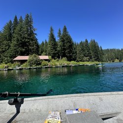
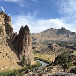
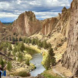
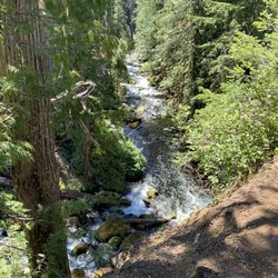
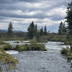
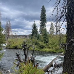
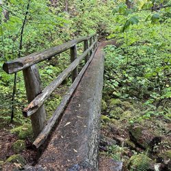
We took the river trail on our last visit to the park. The trek is great, meandering along the Crooked River directly below the wall of rock and climbers above. The trail itself is fairly flat, and should be pretty accessible for almost anyone. There are countless offshoots down to the water and up into the rocks. My only slight disappointment was that it's an out&back. Would be so great if there was at least one place to cross over the river to enjoy a trip back from the other side. There's plenty of parking along the drive in the park, and bathrooms at the start AND down the trail a ways. This time of year there are some gorgeous fall colors to take in along the water. Great, easy hike...and many more to take nearby. read more


More info about River Trail


River Trail - hiking - Updated July 2026
Best of Terrebonne
People found River Trail by searching for…
Things to Do in Terrebonne, Oregon
Hiking Trails With Waterfalls in Terrebonne, Oregon
Photo Spots in Terrebonne, Oregon
Easy Hikes in Terrebonne, Oregon
Playgrounds in Terrebonne, Oregon
Beautiful Views in Terrebonne, Oregon
Places to Take Pictures in Terrebonne, Oregon
Walking Trails in Terrebonne, Oregon
Sunrise View in Terrebonne, Oregon
River Walk in Terrebonne, Oregon
Secret Spots in Terrebonne, Oregon
Fun Things to Do at Night in Terrebonne, Oregon
Scenic Overlook in Terrebonne, Oregon
Waterfalls in Terrebonne, Oregon
Dog Friendly Trails in Terrebonne, Oregon
Swimming Holes in Terrebonne, Oregon
Viewpoints in Terrebonne, Oregon
Night View in Terrebonne, Oregon
Playgrounds for Kids in Terrebonne, Oregon
Trending Searches in Terrebonne, OR
Cliff Jumping near River Trail
Dog Friendly Trails near River Trail
Fruit Picking near River Trail
Lakes & Ponds near River Trail
Off Road Trails near River Trail
Outdoor Activities near River Trail
Public Shower near River Trail
River Swimming near River Trail
Scenic Overlook near River Trail
Secluded Spots near River Trail
Swimming Holes near River Trail
Browse Articles
Browse Nearby
Browse Brands
Related Searches in Terrebonne, OR
Affordable Kayak Rental Services in Terrebonne, Oregon
Best Dog Hiking Trails Around Terrebonne, Oregon
Best Fishing Locations and Guides in Terrebonne, Oregon
Best Off Leash Dog Parks in Terrebonne, Oregon
Best Places for Horseback Riding in Terrebonne, Oregon
Best Sightseeing Experiences Available in Terrebonne, Oregon
Best Waterfalls and Swimming Holes in Terrebonne, Oregon
Discover Dog Friendly Trails to Explore in Terrebonne, Oregon
Discover Lakes & Ponds to Explore in Terrebonne, Oregon
Discover the Best Night Hike Trails in Terrebonne, Oregon
Dog-Friendly Hikes With Dogs in Terrebonne, Oregon
Enjoy Camping Adventures Around Terrebonne, Oregon
Enjoy Kayaking Adventures in Terrebonne, Oregon
Enjoy Off Leash Dog Hikes in Terrebonne, Oregon
Enjoy Tent Camping Spots Around Terrebonne, Oregon
Enjoy Water Activities and Fun in Terrebonne, Oregon
Enjoy the Best Tubing Experiences in Terrebonne, Oregon
Enjoy the Best Walking Path in Terrebonne, Oregon
Enjoy the Best Walking Trails in Terrebonne, Oregon
Experience Thrilling White Water Rafting in Terrebonne, Oregon
Explore Beautiful Parks and Green Spaces in Terrebonne, Oregon
Explore Easy Hikes Perfect for All in Terrebonne, Oregon
Explore Fun Activities to Do in Terrebonne, Oregon
Explore Popular Campgrounds Near Terrebonne, Oregon
Explore Scenic Lakes to Visit in Terrebonne, Oregon
Explore Top Dog Parks in Terrebonne, Oregon Near You
Explore the Best Beach Spots in Terrebonne, Oregon
Explore the Best Swimming Holes Around Terrebonne, Oregon
Family Friendly Hiking With Kids in Terrebonne, Oregon
Find Parks and Recreation Activities in Terrebonne, Oregon
Find Top Dog Friendly Parks to Visit in Terrebonne, Oregon
Find Top-Rated Waterfalls in Terrebonne, Oregon Now
Find the Best Playgrounds to Visit in Terrebonne, Oregon
Find the Best Scenic View Locations in Terrebonne, Oregon
Hiking Trails With Waterfalls in Terrebonne, Oregon
Off Leash Dog Hiking Trails in Terrebonne, Oregon
Popular Outdoor Activities to Try in Terrebonne, Oregon
Popular Picnic Spots to Visit in Terrebonne, Oregon
Safe River Swimming Areas in Terrebonne, Oregon
Safe and Fun Parks for Kids in Terrebonne, Oregon
Top Hiking Trails to Explore in Terrebonne, Oregon
Top Playgrounds for Kids to Enjoy in Terrebonne, Oregon
Top Running Trails to Explore in Terrebonne, Oregon
Top Swimming Lakes to Enjoy in Terrebonne, Oregon
Top Swimming Spots and Pools in Terrebonne, Oregon
Top Things to Do With Kids in Terrebonne, Oregon
Top-Rated Camping Sites in Terrebonne, Oregon