Paulina Falls Photos


More like Paulina Falls
Recommended Reviews - Paulina Falls
Start your review...

Reviews With Photos

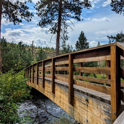
Had never been and no one we knew had either. We live a good 3 hours away and wanted some easier hikes and waterfalls and stumbled on this gem. We found the trails to be well maintained and would've loved to have had our mountain bikes for them too. The main viewpoint is a short 2-3 min walk from the parking lot. We spotted another viewpoint from there that was on the opposite side. Hiking upstream from there, we found Paulina Lake and it's lodge a short distance from the main viewpoint. There's a bridge to cross and headed downstream till we found the other viewpoint... amazing! We headed back and decided to take the trail down to the base of the falls. Found a sweet little spot on the water to have some snacks, crack a beer and chill while cooling off. Barefoot and in swim shorts I scaled the steep rocky rivers edge, making it to the pool created by the falls. It was a pretty simple climb up, just make sure your footing is solid and a good handhold for each step. With the waterfall pouring down on my head, adrenaline pumping I could feel the refreshing water abundantly recharging my soul while taking in the epic views. I will be back... #TheGoodLife

Gorgeous twin falls and easy 0.25 mile trail up to the viewpoint at the top of the falls. The paved trail is beautiful, surrounded by pines and moss. You also have the option of walking down to the bottom of the falls (2 miles) for a different perspective. There's a decent sized parking lot with restrooms available. This requires a $5 day use pass. Highly recommend!

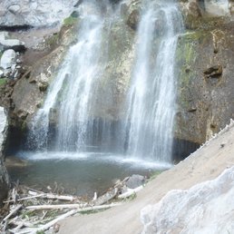
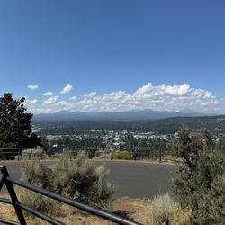
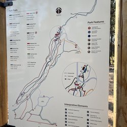
Twin Falls Paulina Falls is part of the Newberry National Volcanic Monument. It is a forested trail leading to the falls plunging 80-feet. There are two ways to get to the falls: 1- a shorter hike leads to the upper viewing area (.25 mile) 2- a longer 2-mile hike leads to views from below Now guess which route we took? If you know me well enough then your answer was #1 LoL! There is really no hiking involved. The paved short trail is also wheelchair and stroller accessible and there is a picnic site in this area. An informative interpretive sign is adjacent to the overview lookout. To give you an idea on this short stroll, the walk to the main viewpoint is incredibly short that we could actually hear the falls from the parking lot. A beautiful trail provides access to the bottom. I believe it is not paved. After small hikes at the Lava Butte Trail and Benham Falls we weren't feeling adventurous hiking down to the lower viewpoint. We saw a couple of kids (or were they adults?) playing at the foot of the falls. It gave me perspective on how huge the boulders were below. The sight of the falls side by side was pretty cool. Review #1121

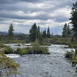
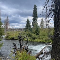
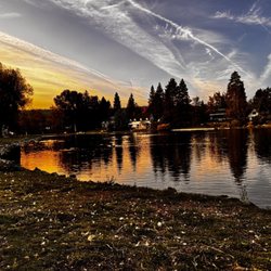
There are two ways to get here - a trail from the lake will bring you to the top of the falls, or a separate parking lot down the road places you between the top of the falls and a trail that swichbacks down the hill to the base of the falls. The upper level viewing is very flat, and the hillside hike is not very taxing. Lovely views everywhere. The falls combines wonderfully with the nearby Big Obsidian Flow to make up a delightful day trip from Bend.

10 months ago
Loved this spot! The falls were easy to get to. The upper view was an easy walk from the parking lot. The lower view point required a little bit of hiking, but nothing strenuous. I would recommend some sneakers or hiking boots for the lower view. read more


2 years ago
Paulina Falls is a stunningly beautiful venue! There's not one, but TWO waterfalls here, and they're visible once you're just a short walk in from the parking lot. Tip: This place is situated inside the Newberry National Volcanic Monument The Falls here are lovely and simply not to be missed, especially when you consider how little effort is required to see this georgous natural attraction in all it's Glory :-) read more


Had never been and no one we knew had either. We live a good 3 hours away and wanted some easier hikes and waterfalls and stumbled on this gem. We found the trails to be well maintained and would've loved to have had our mountain bikes for them too. The main viewpoint is a short 2-3 min walk from the parking lot. We spotted another viewpoint from there that was on the opposite side. Hiking upstream from there, we found Paulina Lake and it's lodge a short distance from the main viewpoint. There's a bridge to cross and headed downstream till we found the other viewpoint... amazing! We headed back and decided to take the trail down to the base of the falls. Found a sweet little spot on the water to have some snacks, crack a beer and chill while cooling off. Barefoot and in swim shorts I scaled the steep rocky rivers edge, making it to the pool created by the falls. It was a pretty simple climb up, just make sure your footing is solid and a good handhold for each step. With the waterfall pouring down on my head, adrenaline pumping I could feel the refreshing water abundantly recharging my soul while taking in the epic views. I will be back... #TheGoodLife read more


Gorgeous twin falls and easy 0.25 mile trail up to the viewpoint at the top of the falls. The paved trail is beautiful, surrounded by pines and moss. You also have the option of walking down to the bottom of the falls (2 miles) for a different perspective. There's a decent sized parking lot with restrooms available. This requires a $5 day use pass. Highly recommend! read more


Twin Falls Paulina Falls is part of the Newberry National Volcanic Monument. It is a forested trail leading to the falls plunging 80-feet. There are two ways to get to the falls: 1- a shorter hike leads to the upper viewing area (.25 mile) 2- a longer 2-mile hike leads to views from below Now guess which route we took? If you know me well enough then your answer was #1 LoL! There is really no hiking involved. The paved short trail is also wheelchair and stroller accessible and there is a picnic site in this area. An informative interpretive sign is adjacent to the overview lookout. To give you an idea on this short stroll, the walk to the main viewpoint is incredibly short that we could actually hear the falls from the parking lot. A beautiful trail provides access to the bottom. I believe it is not paved. After small hikes at the Lava Butte Trail and Benham Falls we weren't feeling adventurous hiking down to the lower viewpoint. We saw a couple of kids (or were they adults?) playing at the foot of the falls. It gave me perspective on how huge the boulders were below. The sight of the falls side by side was pretty cool. Review #1121 read more


3 years ago
There are two ways to get here - a trail from the lake will bring you to the top of the falls, or a separate parking lot down the road places you between the top of the falls and a trail that swichbacks down the hill to the base of the falls. The upper level viewing is very flat, and the hillside hike is not very taxing. Lovely views everywhere. The falls combines wonderfully with the nearby Big Obsidian Flow to make up a delightful day trip from Bend. read more


9 years ago
Wow, beautiful and amazing! Breathtaking! You can also take your dog with you on the trail that leads to the waterfall or you can skip the trail and go to the lookout point where you can see it from above! read more


9 years ago
I have been to this location several times. The last time I was here was for a geology class and was informed the geological history of the falls and have not been able to view this site the same since. If you have an interest in geology you may want to research this falls history before you arrive in order to make this experience truly unique. There has been a history of volcanic deposits and floods through this site that is in clear sight. If you're not interested in geology, there is allot of beauty in the ecology of this location. There are some pretty dense populations of conifer trees, and not too much underbrush making this an awesome place for taking in the views of the creek and the forest. The parking lot is fairly decent in size and on a normal weekday, you shouldn't have a problem finding a spot. There are bathrooms at the trailhead and its a short hike to your destination. Another great feature about this fall is its proximity to lakes, rivers, lava flows, peaks, and wildlife. You can check out many things at once with this fall. But keep in mind it is snowed in for most of the winter and spring due to its higher elevation. Overall I highly recommend a visit to this fall if you are on a time crunch to see as much Central Oregon beauty as possible. Here is a link to the land management agency of this place https://www.fs.usda.gov/recarea/deschutes/recarea/?recid=38440 Here is a link to the trail information https://www.alltrails.com/trail/us/oregon/paulina-creek-falls-newberry-crater-volcanic-monument read more


7 years ago
11 years ago
More info about Paulina Falls
Bend, OR 97709
Directions
(541) 383-5300
Call Now
Hours
Outdoor Amenities
Ask the Community - Paulina Falls
Review Highlights - Paulina Falls


Why does Yelp recommend reviews?
1 review that is not currently recommended
The reviews below are not factored into the business's overall star rating.
9 months ago
Paulina Falls - landmarks - Updated June 2026
Best of Bend
People found Paulina Falls by searching for…
Hiking Trails With Waterfalls in Bend, Oregon
Parks for Kids in Bend, Oregon
Mountain Biking in Bend, Oregon
Walking Trails in Bend, Oregon
Beautiful Views in Bend, Oregon
Hiking With Kids in Bend, Oregon
Points of Interest in Bend, Oregon
Historical Sites in Bend, Oregon
Community Gardens in Bend, Oregon
Trending Searches in Bend, OR
Baseball Fields near Paulina Falls
Boat Rental near Paulina Falls
Cliff Jumping near Paulina Falls
Dog Friendly Trails near Paulina Falls
Fishing Spots near Paulina Falls
Hidden Gems near Paulina Falls
Kayak Rental near Paulina Falls
Lakes & Ponds near Paulina Falls
Landmarks & Historical Buildings near Paulina Falls
Outdoor Activities near Paulina Falls
Pool Supplies near Paulina Falls
Public Pools near Paulina Falls
Public Shower near Paulina Falls
River Swimming near Paulina Falls
River Tubing near Paulina Falls
Scenic Overlook near Paulina Falls
Scenic Restaurants near Paulina Falls
Secluded Spots near Paulina Falls
Soccer Store near Paulina Falls
Sunrise View near Paulina Falls
Swimming Holes near Paulina Falls
Swimming Lakes near Paulina Falls
Things To See near Paulina Falls
U Pick Farms near Paulina Falls
Watch Sunset near Paulina Falls
Browse Nearby
Browse Brands
Related Searches in Bend, OR
Affordable Kayak Rental Services in Bend, Oregon
Best Fishing Locations and Guides in Bend, Oregon
Best Fun Things to Do in Bend, Oregon
Best Off Leash Dog Parks in Bend, Oregon
Best Parks for Parties and Events in Bend, Oregon
Best Places for Horseback Riding in Bend, Oregon
Best Places for Stunning Views in Bend, Oregon
Best Water Parks for Kids in Bend, Oregon
Best Waterfalls and Swimming Holes in Bend, Oregon
Book Engaging Historical Tours in Bend, Oregon
Check Out Great Playgrounds in Bend, Oregon
Check Out Off Road Trails in Bend, Oregon
Discover Baseball Fields Around Bend, Oregon
Discover Beautiful Garden Spots in Bend, Oregon
Discover Dog Friendly Trails to Explore in Bend, Oregon
Discover Famous Monuments in Bend, Oregon
Discover Fun Activities to Do in Bend, Oregon
Discover Historic Sites and Places in Bend, Oregon
Discover Lakes & Ponds to Explore in Bend, Oregon
Discover Popular Landmarks in Bend, Oregon
Discover Popular Photo Spots in Bend, Oregon
Discover Scenic Bike Paths in Bend, Oregon
Discover Scenic Mountain Bike Trails Near Bend, Oregon
Discover Scenic Waterfall Spots in Bend, Oregon
Discover Top Nature Parks to Visit in Bend, Oregon
Discover a Hiking Trail in Bend, Oregon
Discover the Best Beaches in Bend, Oregon
Discover the Best Caves to Explore in Bend, Oregon
Discover the Best Kids Park Spots in Bend, Oregon
Discover the Best Night Hike Trails in Bend, Oregon
Dog-Friendly Hikes With Dogs in Bend, Oregon
Enjoy Arts & Entertainment in Bend, Oregon
Enjoy Camping Adventures Around Bend, Oregon
Enjoy Exciting Mountain Biking Adventures in Bend, Oregon
Enjoy Kayaking Adventures in Bend, Oregon
Enjoy River Tubing Adventures in Bend, Oregon
Enjoy Tent Camping Spots Around Bend, Oregon
Enjoy a Beautiful Waterfall Hike in Bend, Oregon
Enjoy the Best Tubing Experiences in Bend, Oregon
Enjoy the Best Walking Trails in Bend, Oregon
Essential Tips for Every Tourist in Bend, Oregon
Exciting Cliff Jumping Spots in Bend, Oregon
Experience Stunning Sunset Views in Bend, Oregon
Experience Thrilling White Water Rafting in Bend, Oregon
Explore Beautiful Castles and Landmarks in Bend, Oregon
Explore Beautiful Parks and Green Spaces in Bend, Oregon
Explore Bike Rentals Throughout Bend, Oregon
Explore Easy Hikes Perfect for All in Bend, Oregon
Browse Articles
People who viewed Paulina Falls also viewed
LaPine State Park
39 reviews
Newberry National Volcanic Monument
51 reviews
Fort Rock State Park
20 reviews
Deschutes River Trail - River Run Reach
2 reviews
Lava River Cave
22 reviews
Pilot Butte State Park
57 reviews
Bessie Butte Trail
1 review
Deschutes River Trail
3 reviews
Larkspur Trail
2 reviews
Horse Butte Trail
5 reviews