RCA Beach Photos


You might also consider
More like RCA Beach
Recommended Reviews - RCA Beach
Start your review...

2 years ago
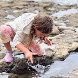
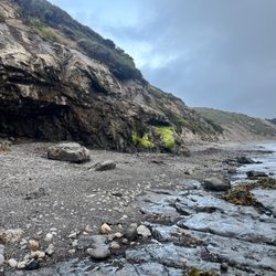
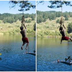
Could not find any trail down from the road or up from the beach, and anyone who says to use the trail to Palomarin Beach must not have walked it recently. Totally overgrown, basically inaccessible--rope ladder is not easy to use if you are carrying bags. Nice beach once you're there, at least during low tide when you have some solid stone to walk on (which creates a few tidepools), but most of the beach is covered with small rocks. Skip this beach unless you plan on wearing long clothing to protect from ticks, wasps, tall brush, and climbing on your hands and knees between the rope ladder and the other rope section. read more


11 years ago
More info about RCA Beach
Bolinas, CA 94924
Directions
Hours
Outdoor Amenities


RCA Beach - beaches - Updated June 2026
Best of Bolinas
People found RCA Beach by searching for…
Tide Pools in Bolinas, California
Things to Do With Kids in Bolinas, California
Hiking Trails in Bolinas, California
Fun Things to Do in Bolinas, California
Swimming Lakes in Bolinas, California
Seashell Beaches in Bolinas, California
Free Beach Parking in Bolinas, California
Kid Friendly Beaches in Bolinas, California
Walking Trails in Bolinas, California
Dog Friendly Beaches in Bolinas, California
Dog Swimming in Bolinas, California
Hiking With Kids in Bolinas, California
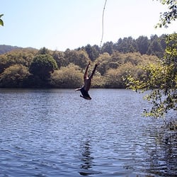
Rope Swing in Bolinas, California
Tourist Attractions in Bolinas, California
Romantic Spots in Bolinas, California
Places to Take Pictures in Bolinas, California
Public Parking in Bolinas, California
Underwater Restaurant in Bolinas, California
Swimming in Bolinas, California
Picnic Areas in Bolinas, California
Trending Searches in Bolinas, CA
Browse Articles
Browse Nearby
BEST of Bolinas, California Restaurants near RCA Beach
BEST of Bolinas, California Coffee near RCA Beach
BEST of Bolinas, California Tide Pools near RCA Beach
BEST of Bolinas, California Things to Do near RCA Beach
BEST of Bolinas, California Vacation Rentals near RCA Beach
BEST of Bolinas, California Breakfast near RCA Beach
BEST of Bolinas, California Lakes near RCA Beach
Browse Brands
Related Searches in Bolinas, CA
Affordable Paddle Board Rental in Bolinas, California
Best Nature Trails for Hiking in Bolinas, California
Best Swimming Beach in Bolinas, California
Best Waterfalls and Swimming Holes in Bolinas, California
Browse Top Hotels in Bolinas, California for Your Stay
Discover Dog Friendly Beaches Near Bolinas, California
Discover Popular Photo Spots in Bolinas, California
Discover Public Pools Open in Bolinas, California
Discover Scenic Beach Camping Sites in Bolinas, California
Discover Sea Shell Beaches Near Bolinas, California
Discover Top Nature Parks to Visit in Bolinas, California
Discover the Best Tide Pools in Bolinas, California
Enjoy Surfing Adventures in Bolinas, California
Enjoy Water Activities and Fun in Bolinas, California
Enjoy a Dog Beach Day in Bolinas, California
Enjoy the Best Walking Trails in Bolinas, California
Experience Thrilling Parasailing Adventures in Bolinas, California
Explore Beautiful Parks and Green Spaces in Bolinas, California
Explore Easy Hikes Perfect for All in Bolinas, California
Explore Popular Campgrounds Near Bolinas, California
Explore Popular Scenic Views Near Bolinas, California
Explore Scenic Lakes to Visit in Bolinas, California
Explore Secluded Beaches to Relax in Bolinas, California
Explore Secret Spots Worth Visiting in Bolinas, California
Explore Top Dog Parks in Bolinas, California Near You
Explore Top Marinas Near Bolinas, California
Explore Top Water Parks in Bolinas, California Today
Explore the Best Swimming Holes Around Bolinas, California
Find Beautiful Views in Bolinas, California
Find Free Beach Parking Options in Bolinas, California
Find Surf Lessons Near You in Bolinas, California
Find Top Skate Parks in Bolinas, California for All Skill Levels
Find Top-Rated Waterfalls in Bolinas, California Now
Find the Best Parks for Picnics in Bolinas, California
Find the Best Playgrounds to Visit in Bolinas, California
Find the Best Swimming Pools in Bolinas, California Today
Great Places to Swim in Bolinas, California
Picnic Areas With BBQ Pits Available in Bolinas, California
Popular Fishing Spots to Explore in Bolinas, California
Popular Picnic Spots to Visit in Bolinas, California
Relax at Popular Beach Parks in Bolinas, California
Safe Beaches for Kids in Bolinas, California
Safe and Fun Parks for Kids in Bolinas, California
Top Paddleboarding Activities in Bolinas, California
Top Places for Snorkeling in Bolinas, California
Top Playgrounds for Kids to Enjoy in Bolinas, California
Top Swimming Lakes to Enjoy in Bolinas, California
Top Swimming Spots and Pools in Bolinas, California