Agate Beach Park Photos


You might also consider
More like Agate Beach Park
Recommended Reviews - Agate Beach Park
Start your review...

Reviews With Photos

Take the fam! Bring rain boots, warm clothes, and some patience. We went during a full moon low tide at sunset, and our four children immediately drop in to looking into the tide pools and crevices. Stay for sunset, it is worth they wait. You get to watch the sunset shimmer behind the distant fog in the pacific. Well worth it.

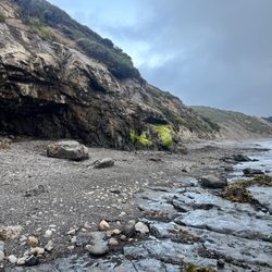
BOLINAS is a village located near three other villages, namely, Stinson Beach, Olema, and Point Reyes Station. Each of these places is a tourist destination, though Bolinas is somewhat less of a tourist destination, because the town itself and the nearby beaches are somewhat scruffy. Nearby Olema (just a cluster of buildings, not even a village) and Point Reyes Station have the best restaurants in the area. Point Reyes National Seashore is a huge park with beaches and undulating cliffs in the Drake's Bay area that are world class, in terms of photogenicity. Now, back to Bolinas. Bolinas has a theater, where one can see performances by the ever-so-excellent and ever-so-beloved San Francisco Mime Troupe (a definite plus). The theater is at Mesa Park, 100 Mesa Rd., behind the Bolinas Firehouse. The beach at Bolinas has many dogs, and local artwork features paintings of dogs (another plus). At the eastern side of Bolinas Lagoon is Audubon Canyon Ranch, where tourists can view a large egret colony. I find lagoons and marshes to be magical things, especially when egrets can be found. Bolinas Lagoon is magical in this way. My motivation in posting this review, was the stranded whale at Agate Beach Park, which attracted modest numbers of visitors during the last week of May 2017. Agate Beach Park is like the beach area at Palomarin Trailhead, in that the beach is narrow, and likely disappears at high tide. On the plus side, at Agate Beach Park and at the beach near Palomarin Trailhead, the views of the ocean are unobstructed. For the S.F. resident who wants to get away from the Coney Island-type crowds found at Stinson Beach, and who has already seen the awesome and remote beaches in the Drake's Bay area, Agate Beach Park is a good alternative. See my attached photo of the stranded whale, at Agate Beach Park. ISSUE OF SMOOTHENED OVOID STONES. At the far northern terminus of Mesa Road is a parking area, with a trail leading northwards, and a spur trail leading to the beach, where one can find countless thousands of rounded stones, smoothened by being jostled billions of times by the surf. The beaches at Drakes Bay also have many beautiful smoothened stones, and on Feb. 17, 2013, I took an ovoid stone about 5 inches long, and with enamel paint, painted a swirling continuous ribbon, and over the ribbon in script, I wrote a diary about the day's events. But Agate Beach does not have huge collections of smoothened stones, and instead has mostly jagged stones released from the crumbling cliff that borders the beach. Too bad.

Wow....not getting the low reviews at all! Is this a fun beach for swimming and taking your family? No. Probably not. But it's certainly not pretending to be, either! Come here for: - The views. Gorgeous cliffs looking out over the rocky coastline. - Fun rocks and sea life. No, there's no agate, but there are plenty of other cool rocks (lots of interesting adder stones!), plus snails, starfish, crabs, and the like. - Tranquility! We were here for a few hours on a weekend and saw one person. As you venture toward the rockier side of the beach, you'll run into some cliffs that are slowly collapsing. Definitely a positive and a negative - it's super cool to watch the little pebbles constantly rolling down the cliffs, but I'm sure it's also potentially dangerous. We had some fun pretending we could crush the soft rocks with our superhuman strength, and then moved away from the falling rocks as quickly as possible.

We woke up at 4 on a rainy and foggy morning to catch the low tide at 5:30 since it is an hour and a half drive from Castro Valley. The tide pooling sounded fun and I was very excited about it. Actually, I was more excited of the possibility of being able to eat a fresh and live sea urchin so I brought spiced vinegar and lemon wedges and a knife for it. If you want to go straight to the beach, don't go to the sign that says "Trail" on the left side unless you want to see the beautiful view from the cliffs and beach from above. The trail still leads you to the beach but just a little farther. If you are catching a low tide and do not want to waste time, go to the one that's on the right of the parking. You can always come back to do scenic sightseeing afterwards. I've done tide pooling back home and it was fun cuz you get to see a lot of sea creatures and fishes. Since this place has way too many kelps, it becomes more too slippery and scary to hop or walk between rocks and the area is mostly covered by it. You may need to lift them to see some star fish, fish and other sea creatures. We didn't do that so we saw nada but a starfish and a dead crab. If you come here for a scenic view of the beach and cliffs, this would be a good place. We didn't come here for that, so we were quite a bit disappointed.

This was our first visit here. My daughter is obsessed with all things beaches and oceans. This beach is very easy access from the parking lot. I checked the time of low tide so we could arrive when she would get a chance to see all that is the tide pools. She had an absolute blast and I was so happy to just watch her go about her way exploring and creating more memories. read more


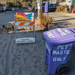
Bolinas is a strange little town. The downtown, what there is of it, looks like it hasn't been updated in 80 years, except for a few newer buildings on Brighton. Go west, young man, and it has the feeling of Carmel with smaller trees. Its history is what makes it strange: in the late 1960s, the hippies moved in, the water supply got maxed out so no more new water permits have been granted since then, and residents started tearing down the signs on Highway 1 that pointed to this town. I've been told that, as the hippies are dying off, families and wealthy people are moving in, so it's slowly becoming more normal. But Bolinas is still a world apart, and intends to stay that way. It does have one unusual feature, though: Agate Beach Park. "Beach" is almost false advertising. The sand is a longish walk north. You don't come here to laze in the sun or barbecue some weenies. You come here to explore the tide pools, gaze in wonder at the cliffs, notice that you can see San Francisco from here, and enjoy the remoteness of the place. Marin County takes care of the place, but when you get to the bottom of the stairs, there is NO development at all. Any development would take away from the natural features. And, in a way, the unique flavor of Bolinas add to the charm. No signs point the way, just as no signs tell you to turn here to get to Bolinas. Agate Beach Park is the edge of town, as far away from tourists as you can get. Driving here is like getting immersed in Bolinas counter-culture. There are no crowds here, and not likely to ever be any. If that interest you, then you'll like this park a lot. By the way, you can also climb to the top of the bluff and get some good views and photos. Basically, Agate Beach Park is where you can explore another place where the Great Eternal Artist did some of His best handiwork, and not fight the crowds to do so. read more

5 years ago
Take the fam! Bring rain boots, warm clothes, and some patience. We went during a full moon low tide at sunset, and our four children immediately drop in to looking into the tide pools and crevices. Stay for sunset, it is worth they wait. You get to watch the sunset shimmer behind the distant fog in the pacific. Well worth it. read more

BOLINAS is a village located near three other villages, namely, Stinson Beach, Olema, and Point Reyes Station. Each of these places is a tourist destination, though Bolinas is somewhat less of a tourist destination, because the town itself and the nearby beaches are somewhat scruffy. Nearby Olema (just a cluster of buildings, not even a village) and Point Reyes Station have the best restaurants in the area. Point Reyes National Seashore is a huge park with beaches and undulating cliffs in the Drake's Bay area that are world class, in terms of photogenicity. Now, back to Bolinas. Bolinas has a theater, where one can see performances by the ever-so-excellent and ever-so-beloved San Francisco Mime Troupe (a definite plus). The theater is at Mesa Park, 100 Mesa Rd., behind the Bolinas Firehouse. The beach at Bolinas has many dogs, and local artwork features paintings of dogs (another plus). At the eastern side of Bolinas Lagoon is Audubon Canyon Ranch, where tourists can view a large egret colony. I find lagoons and marshes to be magical things, especially when egrets can be found. Bolinas Lagoon is magical in this way. My motivation in posting this review, was the stranded whale at Agate Beach Park, which attracted modest numbers of visitors during the last week of May 2017. Agate Beach Park is like the beach area at Palomarin Trailhead, in that the beach is narrow, and likely disappears at high tide. On the plus side, at Agate Beach Park and at the beach near Palomarin Trailhead, the views of the ocean are unobstructed. For the S.F. resident who wants to get away from the Coney Island-type crowds found at Stinson Beach, and who has already seen the awesome and remote beaches in the Drake's Bay area, Agate Beach Park is a good alternative. See my attached photo of the stranded whale, at Agate Beach Park. ISSUE OF SMOOTHENED OVOID STONES. At the far northern terminus of Mesa Road is a parking area, with a trail leading northwards, and a spur trail leading to the beach, where one can find countless thousands of rounded stones, smoothened by being jostled billions of times by the surf. The beaches at Drakes Bay also have many beautiful smoothened stones, and on Feb. 17, 2013, I took an ovoid stone about 5 inches long, and with enamel paint, painted a swirling continuous ribbon, and over the ribbon in script, I wrote a diary about the day's events. But Agate Beach does not have huge collections of smoothened stones, and instead has mostly jagged stones released from the crumbling cliff that borders the beach. Too bad. read more

9 years ago
Wow....not getting the low reviews at all! Is this a fun beach for swimming and taking your family? No. Probably not. But it's certainly not pretending to be, either! Come here for: - The views. Gorgeous cliffs looking out over the rocky coastline. - Fun rocks and sea life. No, there's no agate, but there are plenty of other cool rocks (lots of interesting adder stones!), plus snails, starfish, crabs, and the like. - Tranquility! We were here for a few hours on a weekend and saw one person. As you venture toward the rockier side of the beach, you'll run into some cliffs that are slowly collapsing. Definitely a positive and a negative - it's super cool to watch the little pebbles constantly rolling down the cliffs, but I'm sure it's also potentially dangerous. We had some fun pretending we could crush the soft rocks with our superhuman strength, and then moved away from the falling rocks as quickly as possible. read more


We woke up at 4 on a rainy and foggy morning to catch the low tide at 5:30 since it is an hour and a half drive from Castro Valley. The tide pooling sounded fun and I was very excited about it. Actually, I was more excited of the possibility of being able to eat a fresh and live sea urchin so I brought spiced vinegar and lemon wedges and a knife for it. If you want to go straight to the beach, don't go to the sign that says "Trail" on the left side unless you want to see the beautiful view from the cliffs and beach from above. The trail still leads you to the beach but just a little farther. If you are catching a low tide and do not want to waste time, go to the one that's on the right of the parking. You can always come back to do scenic sightseeing afterwards. I've done tide pooling back home and it was fun cuz you get to see a lot of sea creatures and fishes. Since this place has way too many kelps, it becomes more too slippery and scary to hop or walk between rocks and the area is mostly covered by it. You may need to lift them to see some star fish, fish and other sea creatures. We didn't do that so we saw nada but a starfish and a dead crab. If you come here for a scenic view of the beach and cliffs, this would be a good place. We didn't come here for that, so we were quite a bit disappointed. read more


15 years ago
14 years ago
My husband and I loved it. Not too many people crowding the beach and parking was free. We went this past Sunday and had a nice relaxing day there. I wanted to go to this beach in particular because of, you guessed it, a rockhounding book. Fortunately we came early in the day when the tide was low and there was a bit of fine mist around. Good shoes/hiking shoes are a must since there are a lot of sharp rocks and slippery parts. We found a good amount of oil agate, tumbled by the sea. Will post a picture of the finds! I highly recommend this place to others looking for a nice place to unwind and maybe do some nature photography. read more

12 years ago
8 years ago
15 years ago
12 years ago
13 years ago
11 years ago
More info about Agate Beach Park
Ask the Community - Agate Beach Park
Review Highlights - Agate Beach Park
You might also consider


Why does Yelp recommend reviews?
1 review that is not currently recommended
The reviews below are not factored into the business's overall star rating.
8 years ago
Agate Beach Park - beaches - Updated July 2026
Best of Bolinas
People found Agate Beach Park by searching for…
Tide Pools in Bolinas, California
Crabbing Location in Bolinas, California
Sea Shell Beaches in Bolinas, California
Fishing Spots in Bolinas, California
Secluded Beaches in Bolinas, California
Things to Do in Bolinas, California
Sea Glass Beach in Bolinas, California
Attractions in Bolinas, California
Dog Friendly Hiking Trails in Bolinas, California
Kids Friendly Beaches in Bolinas, California
Fishing in Bolinas, California
Watch Sunset in Bolinas, California
Cliff Diving in Bolinas, California
Scenic View in Bolinas, California
Walking Trails in Bolinas, California
Hiking Trails in Bolinas, California
Scenic Restaurants in Bolinas, California
Bike Paths in Bolinas, California
Park & Forests in Bolinas, California
Boat Launch in Bolinas, California
Skyline View in Bolinas, California
Trending Searches in Bolinas, CA
Beach Chair Rentals in Bolinas, CA
Black Owned Nail Salons in Bolinas, CA
Crabbing Location in Bolinas, CA
Dog Friendly Beaches in Bolinas, CA
Outdoor Basketball Courts in Bolinas, CA
Places To Walk Around in Bolinas, CA
Salt Water Pool in Bolinas, CA
Scenic Overlook in Bolinas, CA
Strawberry Picking in Bolinas, CA
Browse Nearby
BEST of Bolinas, California Restaurants near Agate Beach Park
BEST of Bolinas, California Tide Pools near Agate Beach Park
BEST of Bolinas, California Things to Do near Agate Beach Park
BEST of Bolinas, California Coffee near Agate Beach Park
BEST of Bolinas, California Lakes near Agate Beach Park
BEST of Bolinas, California Breakfast near Agate Beach Park
BEST of Bolinas, California Resorts near Agate Beach Park
BEST of Bolinas, California Hotels near Agate Beach Park
BEST of Bolinas, California Campgrounds near Agate Beach Park
Browse Brands
Related Searches in Bolinas, CA
Affordable Paddle Board Rental in Bolinas, California
Affordable Snorkel Rental Services in Bolinas, California
Best Off Leash Dog Parks in Bolinas, California
Best Parks for Parties and Events in Bolinas, California
Best Water Parks for Kids in Bolinas, California
Book a Snorkeling Tour in Bolinas, California
Check Out Great Playgrounds in Bolinas, California
Discover Baseball Fields Around Bolinas, California
Discover Dog Friendly Beaches Near Bolinas, California
Discover Fun Toddler Parks in Bolinas, California for Your Little One
Discover Kid Friendly Beaches to Visit in Bolinas, California
Discover Popular Bike Trails in Bolinas, California
Discover Popular Photo Spots in Bolinas, California
Discover Public Beaches to Visit in Bolinas, California
Discover Public Pools Open in Bolinas, California
Discover Scenic Beach Camping Sites in Bolinas, California
Discover Sea Shell Beaches Near Bolinas, California
Discover Soccer Fields in Bolinas, California Near You
Discover Top Nature Parks to Visit in Bolinas, California
Discover Top State Parks to Visit in Bolinas, California
Discover Walking Parks in Bolinas, California Near You
Discover the Best Beaches in Bolinas, California
Discover the Best Kids Park Spots in Bolinas, California
Discover the Best Tide Pools in Bolinas, California
Enjoy Surfing Adventures in Bolinas, California
Enjoy a Dog Beach Day in Bolinas, California
Enjoy the Best Picnic Spots and Ideas in Bolinas, California
Enjoy the Best Walking Trails in Bolinas, California
Experience Thrilling Parasailing Adventures in Bolinas, California
Explore Beautiful Parks and Green Spaces in Bolinas, California
Explore Easy Hikes Perfect for All in Bolinas, California
Explore Free Picnic Areas Around Bolinas, California
Explore Fun Activities to Do in Bolinas, California
Explore Off Leash Dog Beaches in Bolinas, California
Explore Parks With Pull Up Bars in Bolinas, California
Explore Picnic Parks Near Bolinas, California
Explore Popular Campgrounds Near Bolinas, California
Explore Popular Kids Parks Throughout Bolinas, California
Explore Popular Picnic Areas Around Bolinas, California
Explore Popular RV Parks Around Bolinas, California
Explore Scenic Lakes to Visit in Bolinas, California
Explore Secluded Beaches to Relax in Bolinas, California
Explore Top Dog Parks in Bolinas, California Near You
Explore Top Water Parks in Bolinas, California Today
Explore the Best Swimming Holes Around Bolinas, California
Find Beautiful Views in Bolinas, California
Find Free Beach Parking Options in Bolinas, California
Find Great Places to Feed Ducks in Bolinas, California