Preserve Trail Photos


You might also consider
More like Preserve Trail
Recommended Reviews - Preserve Trail
Start your review...

Reviews With Photos

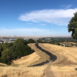
The Preserve Trail is a nice, hidden loop trail near a residential area of Pleasanton. There is a good-sized parking lot at the beginning of the trail, with a restroom and drinking fountain. Then it gets slightly confusing as there are two separate trails you can start from, both leading downhill. Its actually one big loop, though from limited signage its not clear where the best starting point is. Overall, its a pretty well-maintained trail and of moderate difficulty. They have lotsa hills, from the beginning, middle, and even in the end! There is a creek with flowing water that you'll have to hop across, along with some wet spots. We even found one place that was like a swamp and had to turn back. 3 stars - a good place for a short (45 to 90 min) hike that will still challenge you with all those hills. Plusses: * Cell signal * Large, clean parking lot * Well-maintained trails * Nice views of some very fancy homes atop the hill. Minuses: * Lack of signage along the trail. You won't get lost walking in a loop but the trail does fork a few times. * Some swampy parts, which resulted from the rainy season. You may need to do a U-turn as the ground becomes super-soft.

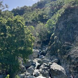
Hiked here Mon 4/1/19 with V. to find Tehran Falls. The Preserve has 1 flushed toilet, no water so bring hand sanitizer and lots of drinking water. There's FREE parking for about 20 cars or so. Print out The Preserve & Moller Ranch Trail Map, it's only a tiny bit useful because most of the trails aren't marked. Check online for blog post on how to find the waterfall too. We saw some wild turkeys, that was cool. From what I remember on how to get to waterfall: We go down the trail, then Left, go over the bridge, then turn Left. Keep going, then we saw sign for Upper Moller Ranch, a little before that you see a nice bench with views of The Preserve- fancy houses. Then keep going up see a Water Tank. Keep going. At a split in trail that's wide, don't go up that ends up at a gate private property, go down a bit, but at the hair-pin turn, go Right on a little trail. That goes to the Waterfall. You will see a steep down on a cliff that's the way to the waterfall, but it's super steep. Go down on your butt is the way I did. I didn't go to the bottom cuz I was already tired and didn't want to have my friend wait forever for me. Plus the waterfall wasn't running that great even at 4/1/19, was dry for a while when I went, guess water from winter dried up already. Then we backtracked and did a loop at The Preserve. We did about 6 miles that day, but I think it can be done in 5 miles, just don't do the extra loop we did.

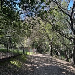
It was a nice day so I got some really blue skies and nice sun in! It was easy to find the trail head once you park in the lot. The trail is well paved throughout. I ended up doing the loop trail which was pretty quick since it ended up only being about 2 miles. There were some parts that are hilly, some parts a bit wet from the rain (so be careful from the mud!), and some under shade... it did feel a little eerie because I was the only one around such huge hills and especially when I was under all the trees/shrubs. I would recommend coming with another person especially if you want to explore other parts. I liked the hike but it was mostly hills. I could see myself coming back with other people so that I can hike other parts of this trail too.

UPDATE: Well I went down to the creek IN several different locations but I didn't really find any evidence of mining equipment. I did find an old telephone pole and a big giant girder, but I don't know that those were related to mining. It's pretty tough to walk along the creek; there's lots of brush. This is a kid friendly Trail in Pleasanton California. There's a drinking fountain and well equipped restroom at the staging area off Laurel Creek Road. There's actually some fun history here that people probably don't know about. The creek nearby which is called Gold Creek, was actually the site of several gold mining events in the history of this area. There is apparently still some mining equipment near near the creek. I'm going to try to find that equipment today.
")
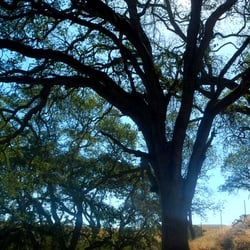
There are two different trails you can take from this trailhead, and I did the 1.3 mile loop. The trail head is easy to find, and it has ample parking, a bathroom, a water fountain, and a trash can. The loop can be a little tricky to follow but I used the All Trails app while out and it helped me to make sure I didn't get lost. The loop has some moderate inclines, but overall I'd rate it easy. It's so beautiful, with expansive views of the area and the gorgeous gold rolling hills. The path isn't wide enough to walk side by side with your hiking buddies and pretty even for the most part. Dogs are allowed (woo!) and it seemed like except for the few rule breakers most people pick up after their pups. It's open from 8am to 6 from April through the end of September, and is limited to daylight hours otherwise. It does get close to homes so it's important to stay on the trail. It's a great easy hike with beautiful views. I'm for sure going to take visiting friends on it to give a quick workout and look at the area.

Nice convenient trail. There is a parking lot at the trail head with spots for about 20 - 25 cars a bathroom and water fountain. The lot has a gate on it that can be locked but I have never seen it locked. The trail sign has posted hours of daylight hours and 8:00 AM to 6:00 PM April 1 to September 30. The trail is on private land but open to the public. There is additional parking at Laurel creek park for 5 - 10 cars. The full loop is ~1.3 miles with an elevation gain of ~350 feet that crosses Gold Creek twice. At the upper crossing I have only encountered a moist trail, and at the lower crossing there is a bridge. For the most part the trail is single track with a few wider sections. The trail is fully exposed to the sun with a few small shade areas near the creek There is an additional spur of about 1/2 mile across an unused road at the north end that connects to Blessing road. There is no parking available at Blessing Road There are connections to the Moller ranch trail. I have seen lots of turkeys and snake skins, but have not actually seen a snake.
Easy trail for beginners or when you just want a quick "hike". Like other Yelpers mentioned, it is a loop, which is nice and you don't have to worry about getting lost! Bring some cold water, a hat, and wear some sunscreen as it gets really hot, as there are sections of the trail with no shade.

This trail has absolutely gorgeous views, especially if you are lucky enough to be there during a sunrise or sunset! It's a bit of a hard trail, definitely was more of a hike than a walk. If you want a challenging but fun hiking trail that puts you into nature this is a nice spot, though maybe a little short.

Beautiful, easy loop trail tucked away in Pleasanton. Not a lot of people know about this trail, so it is never crowded. It is about 1.5 miles around and takes no more than 45 min or so. There is a nice variety of elevation and scenery. There is a free parking lot and a lot of nice houses surrounding this area, so also fun strolling through the neighborhood after you are done with your hike. If you are going counter-clockwise, there is a final left turn you need to make to get back to the parking lot, otherwise you will end up at Foothill Road, so don't make the same mistake I did. Highly recommend for a hidden gem in the east bay. read more
9 months ago
If using google maps to get here, input "The Preserve Staging Area", and it will lead you straight to the parking lot. Otherwise you may end up among the neighborhood homes. This trail is not ideal for running. It's hilly so going uphill is work, and it's made up of rocks and dirt and uneven terrain so it's easy to trip or slip going downhill. But it's not bad for a simple hike, just a short 30-minute trek along the loop. Yes, my legs got a workout from the climbs, but the slopes weren't too steep, the views were lovely, and the atmosphere was peaceful on a Tuesday afternoon. Plus, there's a restroom near the parking lot for convenience. read more


The Preserve Trail is a nice, hidden loop trail near a residential area of Pleasanton. There is a good-sized parking lot at the beginning of the trail, with a restroom and drinking fountain. Then it gets slightly confusing as there are two separate trails you can start from, both leading downhill. Its actually one big loop, though from limited signage its not clear where the best starting point is. Overall, its a pretty well-maintained trail and of moderate difficulty. They have lotsa hills, from the beginning, middle, and even in the end! There is a creek with flowing water that you'll have to hop across, along with some wet spots. We even found one place that was like a swamp and had to turn back. 3 stars - a good place for a short (45 to 90 min) hike that will still challenge you with all those hills. Plusses: * Cell signal * Large, clean parking lot * Well-maintained trails * Nice views of some very fancy homes atop the hill. Minuses: * Lack of signage along the trail. You won't get lost walking in a loop but the trail does fork a few times. * Some swampy parts, which resulted from the rainy season. You may need to do a U-turn as the ground becomes super-soft. read more


Hiked here Mon 4/1/19 with V. to find Tehran Falls. The Preserve has 1 flushed toilet, no water so bring hand sanitizer and lots of drinking water. There's FREE parking for about 20 cars or so. Print out The Preserve & Moller Ranch Trail Map, it's only a tiny bit useful because most of the trails aren't marked. Check online for blog post on how to find the waterfall too. We saw some wild turkeys, that was cool. From what I remember on how to get to waterfall: We go down the trail, then Left, go over the bridge, then turn Left. Keep going, then we saw sign for Upper Moller Ranch, a little before that you see a nice bench with views of The Preserve- fancy houses. Then keep going up see a Water Tank. Keep going. At a split in trail that's wide, don't go up that ends up at a gate private property, go down a bit, but at the hair-pin turn, go Right on a little trail. That goes to the Waterfall. You will see a steep down on a cliff that's the way to the waterfall, but it's super steep. Go down on your butt is the way I did. I didn't go to the bottom cuz I was already tired and didn't want to have my friend wait forever for me. Plus the waterfall wasn't running that great even at 4/1/19, was dry for a while when I went, guess water from winter dried up already. Then we backtracked and did a loop at The Preserve. We did about 6 miles that day, but I think it can be done in 5 miles, just don't do the extra loop we did. read more


It was a nice day so I got some really blue skies and nice sun in! It was easy to find the trail head once you park in the lot. The trail is well paved throughout. I ended up doing the loop trail which was pretty quick since it ended up only being about 2 miles. There were some parts that are hilly, some parts a bit wet from the rain (so be careful from the mud!), and some under shade... it did feel a little eerie because I was the only one around such huge hills and especially when I was under all the trees/shrubs. I would recommend coming with another person especially if you want to explore other parts. I liked the hike but it was mostly hills. I could see myself coming back with other people so that I can hike other parts of this trail too. read more


UPDATE: Well I went down to the creek IN several different locations but I didn't really find any evidence of mining equipment. I did find an old telephone pole and a big giant girder, but I don't know that those were related to mining. It's pretty tough to walk along the creek; there's lots of brush. This is a kid friendly Trail in Pleasanton California. There's a drinking fountain and well equipped restroom at the staging area off Laurel Creek Road. There's actually some fun history here that people probably don't know about. The creek nearby which is called Gold Creek, was actually the site of several gold mining events in the history of this area. There is apparently still some mining equipment near near the creek. I'm going to try to find that equipment today. read more

7 years ago
There are two different trails you can take from this trailhead, and I did the 1.3 mile loop. The trail head is easy to find, and it has ample parking, a bathroom, a water fountain, and a trash can. The loop can be a little tricky to follow but I used the All Trails app while out and it helped me to make sure I didn't get lost. The loop has some moderate inclines, but overall I'd rate it easy. It's so beautiful, with expansive views of the area and the gorgeous gold rolling hills. The path isn't wide enough to walk side by side with your hiking buddies and pretty even for the most part. Dogs are allowed (woo!) and it seemed like except for the few rule breakers most people pick up after their pups. It's open from 8am to 6 from April through the end of September, and is limited to daylight hours otherwise. It does get close to homes so it's important to stay on the trail. It's a great easy hike with beautiful views. I'm for sure going to take visiting friends on it to give a quick workout and look at the area. read more
 - Hiking Near Me - Pleasanton, California")

7 years ago
Nice convenient trail. There is a parking lot at the trail head with spots for about 20 - 25 cars a bathroom and water fountain. The lot has a gate on it that can be locked but I have never seen it locked. The trail sign has posted hours of daylight hours and 8:00 AM to 6:00 PM April 1 to September 30. The trail is on private land but open to the public. There is additional parking at Laurel creek park for 5 - 10 cars. The full loop is ~1.3 miles with an elevation gain of ~350 feet that crosses Gold Creek twice. At the upper crossing I have only encountered a moist trail, and at the lower crossing there is a bridge. For the most part the trail is single track with a few wider sections. The trail is fully exposed to the sun with a few small shade areas near the creek There is an additional spur of about 1/2 mile across an unused road at the north end that connects to Blessing road. There is no parking available at Blessing Road There are connections to the Moller ranch trail. I have seen lots of turkeys and snake skins, but have not actually seen a snake. read more


6 years ago
Easy trail for beginners or when you just want a quick "hike". Like other Yelpers mentioned, it is a loop, which is nice and you don't have to worry about getting lost! Bring some cold water, a hat, and wear some sunscreen as it gets really hot, as there are sections of the trail with no shade. read more

6 years ago
This trail has absolutely gorgeous views, especially if you are lucky enough to be there during a sunrise or sunset! It's a bit of a hard trail, definitely was more of a hike than a walk. If you want a challenging but fun hiking trail that puts you into nature this is a nice spot, though maybe a little short. read more


 - Hiking Near Me - Pleasanton, California")
This is a perfect, quick hike with some nice hills! I also like that it is a loop so there's no back tracking! Beautiful views as well! Lots of bees though so if you're allergic heads up. There's a bathroom too at the start which is nice and plenty of parking! I love this spot and frequent it! read more

9 years ago
9 years ago
11 years ago
10 years ago
9 years ago
11 years ago
11 years ago
More info about Preserve Trail
5875 Laurel Creek Dr
Pleasanton, CA 94566
Directions
Hours
Indoor Amenities
Outdoor Amenities
Ask the Community - Preserve Trail
How many miles is the trail(s)?
Review Highlights - Preserve Trail
You might also consider


Why does Yelp recommend reviews?
1 review that is not currently recommended
The reviews below are not factored into the business's overall star rating.
4 years ago
Preserve Trail - hiking - Updated July 2026
Best of Pleasanton
People found Preserve Trail by searching for…
Hiking Trails in Pleasanton, CA
Beautiful Views in Pleasanton, CA
Waterfall Hike in Pleasanton, CA
Walking Trails in Pleasanton, CA
Scenic Drive in Pleasanton, CA
Running Trails in Pleasanton, CA
Sunrise View in Pleasanton, CA
Secluded Spots in Pleasanton, CA
Dog Friendly Hiking Trails in Pleasanton, CA
Free Things to Do in Pleasanton, CA
Off Road Trails in Pleasanton, CA
Free Parking in Pleasanton, CA
Dog Friendly Parks in Pleasanton, CA
Trending Searches in Pleasanton, CA
Black Owned Nail Salons in Pleasanton, CA
Cliff Jumping in Pleasanton, CA
Jet Ski Rental in Pleasanton, CA
Kayak Rental in Pleasanton, CA
Lakes & Ponds in Pleasanton, CA
Off Road Trails in Pleasanton, CA
Outdoor Activities in Pleasanton, CA
Picnic Spots in Pleasanton, CA
Places To Swim in Pleasanton, CA
Places To Walk Around in Pleasanton, CA
Pool Day Pass in Pleasanton, CA
Public Pools in Pleasanton, CA
Public Shower in Pleasanton, CA
River Swimming in Pleasanton, CA
River Tubing in Pleasanton, CA
Running Trails in Pleasanton, CA
Scenic Night View in Pleasanton, CA
Scenic Overlook in Pleasanton, CA
Soccer Store in Pleasanton, CA
Sunrise View in Pleasanton, CA
Swimming Holes in Pleasanton, CA
Swimming Lakes in Pleasanton, CA
Browse Articles
Browse Nearby
BEST of Pleasanton, California Coffee near Preserve Trail
BEST of Pleasanton, California Restaurants near Preserve Trail
BEST of Pleasanton, California Things to Do near Preserve Trail
BEST of Pleasanton, California Walking Trails near Preserve Trail
BEST of Pleasanton, California Parks near Preserve Trail
BEST of Pleasanton, California Breakfast near Preserve Trail
BEST of Pleasanton, California Hot Springs near Preserve Trail
BEST of Pleasanton, California Campgrounds near Preserve Trail
BEST of Pleasanton, California Ski Resorts near Preserve Trail
Browse Brands
Related Searches in Pleasanton, CA
Affordable Kayak Rental Services in Pleasanton, California
Best Fishing Locations and Guides in Pleasanton, California
Best Nature Trails for Hiking in Pleasanton, California
Best Places for Horseback Riding in Pleasanton, California
Check Out Off Road Trails in Pleasanton, California
Discover Dog Friendly Trails to Explore in Pleasanton, California
Discover Kid Friendly Hiking Trails in Pleasanton, California
Discover Scenic Hiking Trails in Pleasanton, California
Discover Scenic Mountain Bike Trails Near Pleasanton, California
Discover Scenic Waterfall Spots in Pleasanton, California
Discover Walking Parks in Pleasanton, California Near You
Discover a Hiking Trail in Pleasanton, California
Discover the Best Night Hike Trails in Pleasanton, California
Dog-Friendly Hikes With Dogs in Pleasanton, California
Enjoy Camping Adventures Around Pleasanton, California
Enjoy Exciting Mountain Biking Adventures in Pleasanton, California
Enjoy Kayaking Adventures in Pleasanton, California
Enjoy Tent Camping Spots Around Pleasanton, California
Enjoy a Beautiful Waterfall Hike in Pleasanton, California
Enjoy a Peaceful Nature Walk in Pleasanton, California
Enjoy the Best Picnic Spots and Ideas in Pleasanton, California
Enjoy the Best Walking Path in Pleasanton, California
Enjoy the Best Walking Trails in Pleasanton, California
Experience Thrilling White Water Rafting in Pleasanton, California
Explore Beautiful Parks and Green Spaces in Pleasanton, California
Explore Easy Hikes Perfect for All in Pleasanton, California
Explore Fun Activities to Do in Pleasanton, California
Explore Popular Campgrounds Near Pleasanton, California
Explore the Best Beach Spots in Pleasanton, California
Explore the Best Trail Options in Pleasanton, California
Family Friendly Hiking With Kids in Pleasanton, California
Find Beautiful Views in Pleasanton, California
Find the Best Parks for Picnics in Pleasanton, California
Find the Best Scenic View Locations in Pleasanton, California
Great Places to Walk in Pleasanton, California
Hike the Popular Waterfall Trail in Pleasanton, California
Hiking Trails With Waterfalls in Pleasanton, California
Off Leash Dog Hiking Trails in Pleasanton, California
Plan a Scenic Drive Route Near Pleasanton, California
Popular Outdoor Activities to Try in Pleasanton, California
Popular Picnic Spots to Visit in Pleasanton, California
Safe River Swimming Areas in Pleasanton, California
Safe and Fun Parks for Kids in Pleasanton, California
Top Climbing Spots and Gyms in Pleasanton, California
Top Paddleboarding Activities in Pleasanton, California
Top Running Trails to Explore in Pleasanton, California
Top Swimming Lakes to Enjoy in Pleasanton, California
Top Swimming Spots and Pools in Pleasanton, California
Walk Dog Friendly Hiking Trails in Pleasanton, California
Walk the Best Paved Walking Trails in Pleasanton, California