Pit River Access Photos


You might also consider
More like Pit River Access
Recommended Reviews - Pit River Access
Start your review...

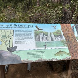
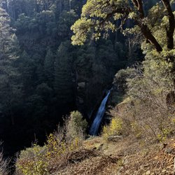
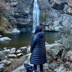
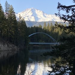
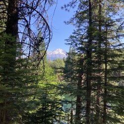
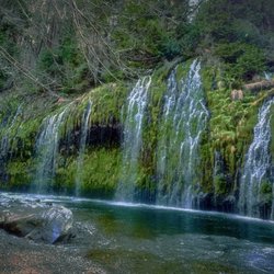
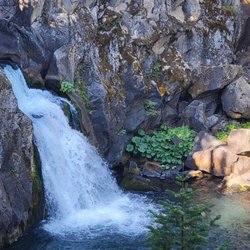
It's a PG&E site with plenty of parking with a recently repaved lot. Looks like you can launch watercraft here with a less than formal ramp. Maybe throw an inflated inner tube in here. You can hear the falls in the background throughout the evening. Permanent portapotty has walls but is still a hole in the ground. Also has a trash can and a recycling bin...NOT to be used for household waste. read more


More info about Pit River Access
24798 Cassel Fall River Rd
Fall River Mills, CA 96028
Directions
Hours
Outdoor Amenities


Pit River Access - hiking - Updated July 2026
Best of Fall River Mills
People found Pit River Access by searching for…
Things to Do in Fall River Mills, California
Hiking Trails With Waterfalls in Fall River Mills, California
Waterfalls in Fall River Mills, California
Walking Trails in Fall River Mills, California
Running Trails in Fall River Mills, California
Off Leash Dog Hikes in Fall River Mills, California
Camping Sites in Fall River Mills, California
Parks for Picnics in Fall River Mills, California
Off Road Trails in Fall River Mills, California
Camping in Fall River Mills, California
Trail in Fall River Mills, California
Swimming Lakes in Fall River Mills, California
To Do in Fall River Mills, California
Redwood Trees in Fall River Mills, California
Swimming Holes in Fall River Mills, California
Scenic Night View in Fall River Mills, California
Trending Searches in Fall River Mills, CA
Browse Articles
Browse Nearby
Browse Brands
Related Searches in Fall River Mills, CA
Affordable Long Term RV Parking in Fall River Mills, California
Best Fishing Locations and Guides in Fall River Mills, California
Best Places for Stunning Views in Fall River Mills, California
Best Waterfalls and Swimming Holes in Fall River Mills, California
Check Out Off Road Trails in Fall River Mills, California
Discover Popular Bike Trails in Fall River Mills, California
Discover Scenic Creeks to Explore in Fall River Mills, California
Discover Scenic Mountain Bike Trails Near Fall River Mills, California
Discover Top Nature Parks to Visit in Fall River Mills, California
Discover the Best Fishing Lake in Fall River Mills, California
Discover the Best Night Hike Trails in Fall River Mills, California
Enjoy Camping Adventures Around Fall River Mills, California
Enjoy Scenic Night View Experiences in Fall River Mills, California
Enjoy Tent Camping Spots Around Fall River Mills, California
Enjoy the Best Picnic Spots and Ideas in Fall River Mills, California
Enjoy the Best Walking Trails in Fall River Mills, California
Explore Free Picnic Areas Around Fall River Mills, California
Explore Free Things to Do Around Fall River Mills, California
Explore Nature Spots Around Fall River Mills, California
Explore Popular Boat Charters Near Fall River Mills, California
Explore Popular Campgrounds Near Fall River Mills, California
Explore Popular RV Parks Around Fall River Mills, California
Explore Popular Scenic Overlook Points in Fall River Mills, California
Explore Scenic Lakes to Visit in Fall River Mills, California
Explore the Best Swimming Holes Around Fall River Mills, California
Explore the Best Trail Options in Fall River Mills, California
Family Friendly Hiking With Kids in Fall River Mills, California
Find the Best Scenic View Locations in Fall River Mills, California
Hiking Trails With Waterfalls in Fall River Mills, California
Must-See Tourist Attractions Around Fall River Mills, California
Perfect Spots to Watch Sunset in Fall River Mills, California
Plan Nature Center Visits in Fall River Mills, California
Plan a Scenic Drive Route Near Fall River Mills, California
Popular Fishing Spots to Explore in Fall River Mills, California
Popular Things to Do in Fall River Mills, California
Relax at Natural Hot Springs Near Fall River Mills, California
Safe River Swimming Areas in Fall River Mills, California
Top Things to Do With Kids in Fall River Mills, California
Top Things to Do With Teenagers in Fall River Mills, California
Top-Rated Boat Rental Services in Fall River Mills, California
Uncover the Best Secluded Spots Around Fall River Mills, California