Morris Peak Photos


You might also consider
More like Morris Peak
Recommended Reviews - Morris Peak
Start your review...

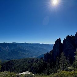
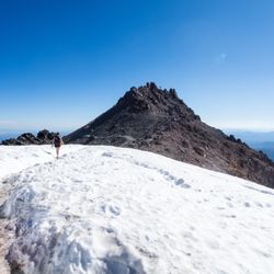
Great hike that is approximately 9.5 miles in length and has approximately 2500 feet elevation gain. I believe the summit itself is roughly 7200 feet in elevation. We accessed the trail at the Walker Pass Owens Peak Segment trailhead where the PCT meets Highway 178. There's no bathroom facilities of any kind on this trail, so I highly recommend using the Walker Pass Campground prior to hitting the trail. Additionally there is zero water to be found on this trail, so come bring plenty of water! The trail itself was easily defined with a steady incline. There's no shade until you hit the middle portion of the hike and there's sporadic shade towards the summit, so make sure you wear a hat and/or sunscreen. There was a high wind advisory the day we went and it was bone-chilling cold! Overall it's an enjoyable hike with amazing views. Not the toughest of hikes, but definitely worth the road trip. read more


More info about Morris Peak
Hat Creek, CA 96040
Directions
Hours
Outdoor Amenities


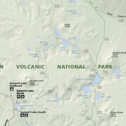


Morris Peak - hiking - Updated July 2026
Best of Hat Creek
People found Morris Peak by searching for…
Things to Do in Hat Creek, California
Hiking Trails in Hat Creek, California
Scenic Drive in Hat Creek, California
Waterfalls in Hat Creek, California
Walking Trails in Hat Creek, California
Off Road Trails in Hat Creek, California
Running Trails in Hat Creek, California
Trail in Hat Creek, California
View Points in Hat Creek, California
Off Leash Dog Hikes in Hat Creek, California
Camping Sites in Hat Creek, California
Tent Camping in Hat Creek, California
Swimming Holes in Hat Creek, California
Scenic View in Hat Creek, California
Dog Friendly Hiking Trails in Hat Creek, California
Attractions in Hat Creek, California
Redwood Trees in Hat Creek, California
Camping in Hat Creek, California
Watch Sunset in Hat Creek, California
Nature Walks in Hat Creek, California
Parks for Picnics in Hat Creek, California
Trending Searches in Hat Creek, CA
Browse Articles
Browse Brands
Related Searches in Hat Creek, CA
Best Fishing Locations and Guides in Hat Creek, California
Best Lookout Points to Visit in Hat Creek, California
Best Nature Trails for Hiking in Hat Creek, California
Best Spots for Star Gazing in Hat Creek, California
Check Out Off Road Trails in Hat Creek, California
Discover Dog Friendly Trails to Explore in Hat Creek, California
Discover Popular Bike Trails in Hat Creek, California
Discover Popular Photo Spots in Hat Creek, California
Discover Scenic Mountain Bike Trails Near Hat Creek, California
Discover Top Nature Parks to Visit in Hat Creek, California
Discover a Hiking Trail in Hat Creek, California
Discover the Best Night Hike Trails in Hat Creek, California
Dog-Friendly Hikes With Dogs in Hat Creek, California
Enjoy Camping Adventures Around Hat Creek, California
Enjoy Tent Camping Spots Around Hat Creek, California
Enjoy the Best Night View Spots in Hat Creek, California
Enjoy the Best Walking Trails in Hat Creek, California
Experience Stunning Sunset Views in Hat Creek, California
Explore Easy Hikes Perfect for All in Hat Creek, California
Explore Popular Campgrounds Near Hat Creek, California
Explore Popular RV Parks Around Hat Creek, California
Explore Popular Scenic Overlook Points in Hat Creek, California
Explore Popular View Points Around Hat Creek, California
Explore Scenic Lakes to Visit in Hat Creek, California
Explore Secret Spots Worth Visiting in Hat Creek, California
Explore the Best Boating Spots in Hat Creek, California
Explore the Best Swimming Holes Around Hat Creek, California
Explore the Best Trail Options in Hat Creek, California
Family Friendly Hiking With Kids in Hat Creek, California
Find Beautiful Views in Hat Creek, California
Find Fun Kids Activities Outdoor in Hat Creek, California
Find Parks and Recreation Activities in Hat Creek, California
Find Top Dog Swimming Spots in Hat Creek, California
Find the Best Parks for Picnics in Hat Creek, California
Find the Best Playgrounds to Visit in Hat Creek, California
Find the Best Scenic View Locations in Hat Creek, California
Hiking Trails With Waterfalls in Hat Creek, California
Off Leash Dog Hiking Trails in Hat Creek, California
Perfect Spots to Watch Sunset in Hat Creek, California
Plan Nature Center Visits in Hat Creek, California
Plan a Scenic Drive Route Near Hat Creek, California
Popular Picnic Spots to Visit in Hat Creek, California
Popular Places to Take Pictures in Hat Creek, California
Popular Things to Do in Hat Creek, California
Safe River Swimming Areas in Hat Creek, California
Safe and Fun Parks for Kids in Hat Creek, California
Top Playgrounds for Kids to Enjoy in Hat Creek, California
Top Running Trails to Explore in Hat Creek, California
Top Swimming Lakes to Enjoy in Hat Creek, California
Uncover the Best Secluded Spots Around Hat Creek, California
People who viewed Morris Peak also viewed
Heart Lake in-and-back Hike
3 reviews
Mill Creek Falls
1 review
Devils Kitchen Trail
2 reviews
Chaos Crater up-and-back hike
1 review
Kings Creek Falls down-and-back
1 review
Buck Peak
1 review
Subway Cave & Lava Tubes
36 reviews
Eskimo Hill
8 reviews
Paradise Meadows up-and-back
2 reviews
Manzanita Lake loop
10 reviews