Devils Kitchen Trail Photos


You might also consider
More like Devils Kitchen Trail
Recommended Reviews - Devils Kitchen Trail
Start your review...

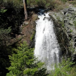
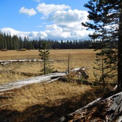
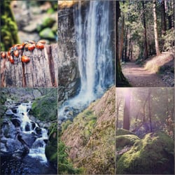
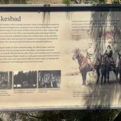
Moderate hike with a view worth the hike. It's 4.2 miles round-trip, but the trail is relatively flat throughout. You'll be walking through a beautiful, flat meadow then slowly going slightly uphill the rest of the way. I was lucky enough to catch a bear sighting along the way and watched a bear ripping up tree bark to forage for bugs. You can choose to ride a horse on the trail, but it will only get you to a certain point; you'll still need to hike maybe half a mile to reach the final end point: Devils Kitchen. The end has great up-close views of Lassen's steam vents and boiling springs. You'll have to cross over small sections of the sulfur springs, so watch your step! There's still some work being done at Devils Kitchen and I saw park crew members carrying up logs to the trail to build more fences, so respect the park signs and stay on trail. Parking is somewhat difficult near the trailhead since there's no clear parking lot, but there's more parking available if you're willing to walk a bit more. read more


12 years ago
Decent hike moderate to beginner level 2.1 miles each way, approximately 1.75hr hike. Devils kitchen is at the end of the hike well worth the effort. read more


More info about Devils Kitchen Trail
Chester, CA 96020
Directions
Visit Website
http://www.lassenhiking.org
Hours
Outdoor Amenities


Devils Kitchen Trail - hiking - Updated June 2026
Best of Chester
People found Devils Kitchen Trail by searching for…
Trending Searches in Chester, CA
Beaches near Devils Kitchen Trail
Boat Rental near Devils Kitchen Trail
Fishing Spots near Devils Kitchen Trail
Jet Ski Rental near Devils Kitchen Trail
Kayak Rental near Devils Kitchen Trail
Mountain Bike Trails near Devils Kitchen Trail
Parks near Devils Kitchen Trail
Places To Take Pictures near Devils Kitchen Trail
River Swimming near Devils Kitchen Trail
Splash Pad near Devils Kitchen Trail
Sunset View near Devils Kitchen Trail
Browse Articles
Browse Brands
Related Searches in Chester, CA
Affordable Kayak Rental Services in Chester, California
Affordable Paddle Board Rental in Chester, California
Best Fishing Locations and Guides in Chester, California
Best Fun Things to Do in Chester, California
Best Nature Trails for Hiking in Chester, California
Best Places for Horseback Riding in Chester, California
Check Out Off Road Trails in Chester, California
Discover Dog Friendly Trails to Explore in Chester, California
Discover Lakes & Ponds to Explore in Chester, California
Discover Popular Bike Trails in Chester, California
Discover Scenic Mountain Bike Trails Near Chester, California
Discover a Hiking Trail in Chester, California
Dog-Friendly Hikes With Dogs in Chester, California
Enjoy Camping Adventures Around Chester, California
Enjoy Exciting Mountain Biking Adventures in Chester, California
Enjoy Kayaking Adventures in Chester, California
Enjoy Tent Camping Spots Around Chester, California
Enjoy the Best Walking Trails in Chester, California
Exciting Cliff Jumping Spots in Chester, California
Experience Thrilling White Water Rafting in Chester, California
Explore Beautiful Parks and Green Spaces in Chester, California
Explore Bike Rentals Throughout Chester, California
Explore Easy Hikes Perfect for All in Chester, California
Explore Fun Activities to Do in Chester, California
Explore Popular Campgrounds Near Chester, California
Explore Popular RV Parks Around Chester, California
Explore Popular Scenic Overlook Points in Chester, California
Explore Popular View Points Around Chester, California
Explore Scenic Lakes to Visit in Chester, California
Explore the Best Swimming Holes Around Chester, California
Family Friendly Hiking With Kids in Chester, California
Find Beautiful Views in Chester, California
Find Parks and Recreation Activities in Chester, California
Find Top-Rated Disc Golf in Chester, California
Find the Best Playgrounds to Visit in Chester, California
Find the Best Scenic View Locations in Chester, California
Find the Best Swimming Pools in Chester, California Today
Hiking Trails With Waterfalls in Chester, California
Perfect Spots to Watch Sunset in Chester, California
Popular Kids Activities in Chester, California
Popular Picnic Spots to Visit in Chester, California
Popular Things to Do in Chester, California
Relax at Natural Hot Springs Near Chester, California
Safe River Swimming Areas in Chester, California
Top Paddleboarding Activities in Chester, California
Top Running Trails to Explore in Chester, California
Top Swimming Lakes to Enjoy in Chester, California
Top Things to Do With Kids in Chester, California