Cancel

    Open app

    Search

    Cluster Lakes Loop Hike

    4.0 (3 reviews)

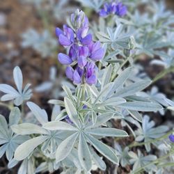
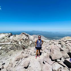
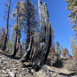
    Cluster Lakes Loop Hike Photos

    You might also consider

    More like Cluster Lakes Loop Hike

    Recommended Reviews - Cluster Lakes Loop Hike

    Your trust is our priority, so businesses can't pay to alter or remove their reviews. Learn more about reviews.
    Yelp app icon
    Browse more easily on the app
    Review Feed Illustration

    6 years ago

    Helpful 3
    Thanks 0
    Love this 1
    Oh no 0
    Photo of Brandi L.
    20
    56
    24

    13 years ago

    Helpful 1
    Thanks 0
    Love this 0
    Oh no 0

    16 years ago

    Helpful 1
    Thanks 0
    Love this 0
    Oh no 0

    Verify this business for free

    Get access to customer & competitor insights.

    Verify this business

    Bumpass Hell Trail - Boardwalk

    Bumpass Hell Trail

    4.9(26 reviews)
    26.8 km

    One of my top two hikes in Lassen National Park, and probably their most popular and well-known…read morehike. If you have the chance to hike down to Bumpass Hell, I'd highly recommend you do it. If you visited Sulphur Works, that's just a small bit of what Bumpass Hell has to offer. It's about a 3 mile round-trip hike with only about 200 elevation gain. All in all, it was a pretty easy hike. The views of these hot springs are absolutely gorgeous - a good variety of hydrothermal areas with such strikingly beautiful colors. If you've been to Yellowstone National Park, it might be a bit of a let down because the ones there are next level. So just keep that in mind when visiting! Make sure to stay on the boardwalk. The ground off trail is completely unpredictable and can lead to severe injuries. This trail is only open about 4 months of the year. So check the website in advance. It also gets so busy as this is their park gem. And there is not as much parking as you would like. So plan accordingly to ensure you'll be able to do the hike - the ranger did advise to go earlier in the morning. Amazing hike in Lassen. Highly recommend!

    A Must-See Hike in Lassen Volcanic National Park!…read more Bumpass Hell is a fantastic hike and one of the highlights of Lassen Volcanic National Park. The trail offers incredible geothermal features--bubbling mud pots, steaming vents, and vibrant colors that make it feel like you're walking through another world. Keep in mind, the hike is at high elevation, so the trail is typically only open from July through late October, depending on snow conditions. Please inform yourself before traveling here. In some years, it might not open until August - based on the information provided by rangers. Be sure to check trail conditions before you go, especially if Bumpass Hell is a must-do on your list. National Park fee applies. Even if the trail happens to be closed, don't worry--there are plenty of other great hikes throughout the park to explore. But if it's open, this one is absolutely worth the trip! If you happened to be fluffy like me, take it slow and drink water.

    Photos
    Bumpass Hell Trail
    Bumpass Hell Trail
    Bumpass Hell Trail - The Bumpass hell area

    See all

    The Bumpass hell area

    Mill Creek Falls

    Mill Creek Falls

    5.0(1 review)
    14.5 km

    The trail to Mill Creek Falls begins right off to the side of the new Kohm Yah-mah-nee Visitor…read moreCenter in the Southwest parking area. The trail is somewhat easy-moderate, depending how fit you are of course. It has a round trip distance of 4.6 miles with various areas of inclining slopes. The path was not smooth and in many spots there was snow blocking the way (but this was a few weeks ago and it may have melted by now). Hiking poles were very useful here. This trail isn't for those looking for an easy stroll. Keep a close eye on the trail too because it wasn't clearly marked and there are areas were you can get off the main path. With that being said, the hike and the actual falls were beautiful. Along the way there were open areas that offered lovely views of various mountain peaks, as well as areas with towering trees that loomed overhead and offered much leafy shade. There was one part of the trail that brought us to a hillside covered with bushes of yellow wildflowers, which was absolutely beautiful. The Mill Creek Falls itself was stunning. You can walk across a bridge that runs above its cascading waters and also across a second little bridge further up from the first. The bridge gives you a spectacular view of the canyon between the two hills. Be careful though because the wooden bridges do not have railings. It's hard to put into words the beauty and majesty of a natural waterfall. You just have to see it for yourself.

    Photos
    Mill Creek Falls
    Mill Creek Falls
    Mill Creek Falls

    See all

    Heart Lake in-and-back Hike - Downed trees on the trail

    Heart Lake in-and-back Hike

    4.0(3 reviews)
    20.3 km

    We decided to backpack in to the lake and spend the night as our first attempt at backpacking. We…read morechose this spot because since it is in the National Forest, not the National Park, it is dog friendly, plus it's not often traveled. The road is a good gravel road. No problems for any type of vehicle. You park on the side of the road in a small turnout. No permit needed. The trailhead is well marked. The trail is all uphill, until a few hundred feet from the lake. It's listed as an easy hike, but I think it should be considered a moderate hike. The uphill hike is already on the edge of being moderate, but if you add in the dozens of downed trees, it definitely makes the hike more difficult. In a 25 lb pack, those things are really irritating. Most you can step over, but there are several you have to climb, and as of yesterday 9/14/13, 3 that have to crawled under. Almost at the lake, you cross South Digger Creek. In September this creek is a few inches high and there are lots of rocks to hop over, but I would imagine in the spring this is quite higher from the snow run off. The lake is small, but very scenic. It was heavy on the weeds and quite green though, so we were not going to swim in it. We decided to hike back to the creek so that we could use the creek water (still filtered) for drinking. We found some decent flat spots on the creek to sleep and were very comfortable. The lake, I later found out is quite full of leaches, so do not swim in it. Hang your food, I found a few piles of bear poo around the lake. You cannot make a campfire, only stove use in the summer. Please don't burn our forest down with illegal campfires. Once you see all the downed trees, you will agree this place is a disaster waiting to happen. This was a great place to try backpacking out and I recommend it for being very fun for dogs. See my pictures of the trip attached on the site.

    This is a great hike but be prepared. As of our hike (6/3/2012), the trail is in need of…read moremaintenance. There are numerous logs down across the trail and the trail is quite difficult to pick up in places. In one place, close to the lake, the trail leads right into a swamp area. If possible, have a GPS and a map. It's pretty much all up hill on the way in but the views at the lake are well worth the trip.

    Photos
    Heart Lake in-and-back Hike - Heart Lake

    Heart Lake

    Heart Lake in-and-back Hike - Trailhead

    Trailhead

    Heart Lake in-and-back Hike - South Digger Creek

    See all

    South Digger Creek

    Drakesbad Guest Ranch - View of facilities from above the bathhouse.

    Drakesbad Guest Ranch

    3.6(40 reviews)
    10.0 km

    We spent our 45th wedding anniversary, July 2025. We love this place. Even after the fire(s), it's…read moreLassen Park! Beautiful! The guest ranch is a wonderful base camp to experience this part of the park. The ranch staff make the experience happen. We felt like family (in the good way). These folks actually care. Look closely at their website for what they offer. For us, it was like you'd think of an early 1900s, Adirondack's mountain motor lodge to be like. Rustic but regal. The staff made it regal for us.

    This is a nice little spot close to Lassen Ntl Park. We were glad to get out of the house and spend…read morea long weekend in nature. The cabins have no electricity and there is no cell phone service, so it's great if you want to get away from everything. There are some hikes available close by. Driving to the main part of the park actually takes about 90 minutes, so it's ok if you want to visit the park once, but doing it every day is very time consuming. Due to the pandemic food was only served outside. The food was pretty good, our server was very nice, however they were a little bit understaffed and it could take a long time to get dinner or breakfast. (Can be annoying if you're trying to get a head start on the busier trails). Overall the staff was really nice and we enjoyed our time in this beautiful and serene area.

    Photos
    Drakesbad Guest Ranch - It was my birthday! The staff treated us like family.

    It was my birthday! The staff treated us like family.

    Drakesbad Guest Ranch - A little history.

    A little history.

    Drakesbad Guest Ranch

    See all

    Lassen Volcanic National Park - Lassen Peak

    Lassen Volcanic National Park

    4.7(241 reviews)
    4.7 km

    For how relatively close we live to Lassen, it's a shame we didn't make it up here sooner! This…read morepark is absolutely beautiful and didn't have nearly the amount of people as we expected. Made for a peaceful trip. There are so many wonderful things to see and do here that I wish we had more time to really explore it all. The Paradise Meadow Trail was a surprisingly wonderful, peaceful trail that had very few people on it and ended with a gorgeous view overlooking a grassy field and the mountains beyond. Very small parking area (5ish spots), so if you wanna do it, take a parking spot when you can! We also hiked the Lassen Peak Trail up to the true summit. Definitely a strenuous hike, but it's worth it at the end when you're looking out over Lassen National Park. But, the gem of Lassen National Park, is Bumpass Hell Trail. Only open for about 4 months of the year, this hike brings you to the park's main hydrothermal area. Both beautiful and awe-inspiring, it's definitely worth the walk. Parking can be tough, so plan ahead. And if you've been to Yellowstone, definitely temper your expectations - it's beautiful but doesn't reach the grandeur of their hydrothermal areas. The only thing on our list we did not get to visit was Manzanita Lake. Wish we could've made it there, but we traded our time for the lake to summit Lassen Peak. So it'll definitely be a must-stop on our return trip. Overall, Lassen was such an incredible time. You can do it in one day if that's all you have, but if you can manage at least 2 days, you'll get to experience more of what the park has to offer. Highly recommend!

    Only visited Lassen for a short afternoon hike at Manzanita Lake, but what a beautiful park it is…read more Since it's a National Park there was a $30 entrance fee, no one was at the booth when we arrived, but they had signage on how to pay online, and told you where you could find wifi to do so. We did the Manzanita Lake loop, which was about two miles. The trail was easy but took a long time because we kept stopping to take pictures of the beautiful views. We did the trail clockwise and it took a little while to get to the ultimate view, but I was glad it wasn't immediate so that we had something to really look forward to while on the trail. We parked at the Loomis Museum lot where there was a bathroom and small visitor center/gift shop. Parking was pretty full when we arrived, but emptied out quite a bit when we were leaving. They had kayak rentals on the lake, we had originally planned to do it, but time didn't permit on this trip. Rangers at the visitor center/shop were very knowledgeable, I heard one giving information about the plethora of trials and areas of the park, and wow are there a lot of trials!

    Photos
    Lassen Volcanic National Park
    Lassen Volcanic National Park
    Lassen Volcanic National Park

    See all

    Lassen Peak Trail

    Lassen Peak Trail

    4.8(10 reviews)
    11.6 km

    We made a spur of the moment choice to hike up Lassen Peak, which might have been for the best? We…read morehad a lot less time to question our choices regarding this strenuous hike, but it was 100% worth it in the end. A five mile roundtrip, strenuous hike, this took us about 5-6 hours to complete - including the time we spent enjoying the view at the peak. And the hike up is definitely steep - about a 2,000ft elevation gain. We just went slow and steady, and it honestly wasn't as bad as I expected it to be. Just enjoy taking in all the surrounding beauty - you get gorgeous views of Lassen National Park from the trail. You'll get to the first summit, and there will be some plaques to read amongst the limited views. BUT, you can keep going a short distance more to reach the true summit. This last bit of trail is definitely unmaintained with more loose gravel, rocks, and a bit of climbing. We even had a bit of snow in this area in July. So definitely be safe if you choose to continue, but we found it so fantastic at the end. We found a place to sit, had a snack, and just took it all in. If you do choose to continue to the true summit, be aware of the rocks and use caution. They are very unstable and should not be used as leverage when climbing up or down. Pack lots of water, bring some food, and don't be afraid to take a lot of breaks. There is no shade, so bring a hat and some sunscreen. Plenty of parking at the trailhead. Probably one of our top 5 difficult hikes, but it was so worth it. Highly recommend.

    This was the trail we kept on postponing due to mother nature. The trail has always been blocked by…read moresnow on previous visits, but finally we did it! It's one of the reasons we keep coming back to Lassen National Park as we needed it to be checked off on the list. The trail was not difficult as it looks. Just remember it's not a race and keep a steady pace. Staring the trail at 7 AM probably made it easier. I honestly think earlier the better. I don't do well with the heat. Trekking poles are recommended as it will save your knees on the way down. The view is spectacular and worth the time. When you reach the top, it doesn't stop there. Make sure you get to the summit. You are close. It's one of those hikes I'm so glad I've completed and would do it again if the opportunity arises.

    Photos
    Lassen Peak Trail - Made it to the top!

    Made it to the top!

    Lassen Peak Trail - The other side of the peak

    The other side of the peak

    Lassen Peak Trail - That's Mount Shasta viewed from the peak.

    See all

    That's Mount Shasta viewed from the peak.

    Kings Creek Falls down-and-back - Lupine

    Kings Creek Falls down-and-back

    5.0(1 review)
    9.2 km

    A gorgeous waterfall with an equally stunning hike throughout! I had originally planned to hike…read moreLassen Peak but there was still too much snow for the hike to be considered safe in condition. Decided to hike the 5 mile loop trail from Kings Creek to Bench Lake instead and it was awesome! Came here on Memorial Day Weekend around 8:30 am, and I was able to find a close spot near the trailhead. There's no actual parking lot near the Kings Creek staging area, but you can easily park along the road. By the time I finished my hike though, the cars were lined down the highway for almost a mile! Would definitely get here early to secure parking, and especially since it got HOT in the afternoon. There was still snow on the trail in late May. In fact, there was a huge pile of snow right at the beginning of the trailhead. Another lady and I realized that the trail was actually down a set of stairs that we couldn't see because snow was blocking our view. The Kings Creek Trail starts here. The hike to the falls is actually pretty easy. It's a short 2.7 miles round trip, but you can extend your hike by connecting to several other trails nearby. I hiked a 5ish mile loop to I Kings Creek, Bench Lake, and back. The trail starts off pretty mild through a shaded forest that runs alongside Kings Creek. You can hear the water from the creek flowing almost the entire time. The trail was a bit hard to follow due to all of the large snow chunks, but there were several small reg flag trail markers that helped to keep me on track. There's a small break in the trees where you'll have some of the most amazing views of the backside of Mount Lassen as well as the beautiful Shasta Valley. The views are pretty unbelievable here. A little over a mile in, you'll reach Kings Creek Falls. There wasn't anybody at the viewpoint when I arrived, and I had the beautiful view of the falls all to myself. Not too many people on this trail, so it was very enjoyable. From here, you can either go back the way you came, or you can connect to another trail. I took the loop trail to Bench Lake. After Kings Creek Falls, the trail becomes a little hard to follow again, but there are some trailhead signs to keep you on track. Bench Lake is small but very peaceful. Again, there was nobody there when I went. I took a break and had lunch here, and didn't see a soul the entire time (just the ants that really wanted my food). After Bench Lake, there's a steepish hill that you'll hike through but it's shaded. The trail continues until it loops back to the tail end of the Kings Creek trail. Some exposed spots but if you're going clockwise, the sun will be facing your back. Also, there was a ton of thick snow that I had to hike through. If you're coming in May, make sure to wear waterproof hiking boots if you don't want wet socks. The scenery throughout this hike is so amazing. Every little stop and turn affords you the most striking views. This is a hike that I would definitely do again. Kings Creek Falls is beautiful and the hike alone is worth the trek.

    Photos
    Kings Creek Falls down-and-back - Devastation after the Dixie Fire

    Devastation after the Dixie Fire

    Kings Creek Falls down-and-back
    Kings Creek Falls down-and-back - Falls

    See all

    Falls

    Cluster Lakes Loop Hike - hiking - Updated May 2026

    Loading...
    Loading...
    Loading...