Bumpass Hell Trail Photos


You might also consider
More like Bumpass Hell Trail
Recommended Reviews - Bumpass Hell Trail
Start your review...

Reviews With Photos

Bumpass Hell is the largest hydrothermal area in the park and marks the principal area of upflow of steam & discharge from the Lassen hydrothermal system. The temperature of high-velocity steam jetting from Big Boiler, the largest fumarole in the park, has been measured as high as 322°F, making it one of the hottest fumaroles in the world. You need to stay on the boardwalk, as the hydrothermal may give way underfoot, which may cause severe injuries. This place is named after Kendall Vanhook Bumpass, whom broke through a thin crust above a scalding hot mudpot. His leg was badly scalded & eventually had to be amputated. If you're looking for a good hike while visiting Lassen National Park, Bumpass Hell is a good one. It is long, and has some steep areas, but the views are gorgeous along the way.

Lassen National Park is other worldly! California has a very diverse geography, but when you think of California, you could not picture this in your wildest dreams. Bumpass Hell Trail will quite literally make you feel like you've gone through the forest and came out the other side on Mars. Stark white rock scapes accented by colorful mineral deposits greet you as you emerge from the trees. Muddy creeks filled with water warmed by the earth trickle along the surface, while ominous looking pools bubble in the background filling the air with a steamy foggy haze. The trail allows you to walk along a well maintained boardwalk that gets you close to this natural geothermal phenomenon. There are signs all over warning hikers to stay on the pathways, as the ground could give way, plunging you into potentially inescapable lava hot mud. That very thing happened to Mr. Bumpass, who guided early explorers through the area to see this for themselves. His accident is why the trail bears the name. All in all this is a relatively easy hike. About 2-3miles out and back with no serious inclines or declines and a very cool payoff. I'd say it's great for families and can be done in a very short time. The parking lot is decent, but if the park is busy, I could see it filling fast.

we ran out of time to hike this trail, but the view from the trailhead/vista point is absolutely gorgeous! i found a semi-secret rock to sit on and just relax and admire the view for a few moments...be careful though, b/c the rock could be a bit slippery and on a windy day, you could be blown into the valley! the trail is about 2 1/2 miles long (roundtrip) and rated as easy, so suitable for families with young children. the story goes, kendall bumpass, an early settler, was guiding some folks through this area and accidentally broke thru the surface of a geothermal area, and one of his legs was scalded from the steaming hot mudpot. ouch! now, there are guardrails and signs around these mudpots so that you can only look but not touch (and fall thru!) another gem in lassen nat'l park that is not to be missed!

Great wonder of the world. The home is moderate not to hard or easy. We walked a trail for about 500 feet which goes up and around the mountain. The trail is uphill 500 feet and then about 250 feet downhill and then you end up at the Bumpass Hell site. It's not as big of an area as I had thought we saw a few spurts coming out of the holes The trail was not to crowded we arrived at about 3pm it took us about an 2 Hours Total we are not advent hikers and do not walk period or exercise so the hike was a journey for us. You go up and around the mountain for a long time before you get to the bottom we almost gave up but kept on going. When we finally arrived it was a nice feeling to be in flat ground the pathway at the Bumpass path is a sturdy bridge platform that you can walk on and see a few of the earths wonders. Now the hike back was the hard part for us the 250 feet that was downhill in the way there is now an uphill thar you have to go back on that hill was much worst than the entire hike it was very HOT and my body wanted to die right there once we finally made it up that bottom hill the long uphill to get there is now a nice down around the mountain which was much easier than going. So all in all the trail back is worst than the walk there. Just do it and it's worth it

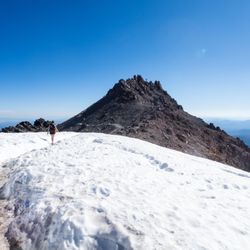
Very cool hike at Lassen National Park. Not to be missed since it's a one-of-a-kind trail that showcases the interesting geology of the area. The parking area is a few miles from the southwest entrance. It does fill up, however. Even on a Tuesday morning, I had to circle the lot to find a spot (I noticed, driving past it again around 4 pm, it had many more open spaces.) There are scenic views right from the lot, but you'll want to head up the trail for even more overlooks and the quintessential Lassen views. It's a well graded trail that inclines gently up through forested area, interspersed with rocky overlooks and a few small meadows. You'll reach the boardwalk area and head downhill to view the steam and boiling mud. It's an amazing landscape full of striking contrast and colors. It's an other worldly landscape for sure. On the way back up. I'd recommend taking the "Frying Pan" spur. It cuts a bit off the uphill and has some of the most spectacular views of the boardwalk area. There's a short uphill back out, before the trail levels out and then descends back to the lot. It's not super challenging but it's warm and open in that section. You can overheat on a summer day. It's a must do hike in Lassen and is about 3 miles round trip (with longer hikes that also can embark from here.) Lots of informational plaques and truly a wondrous hike.


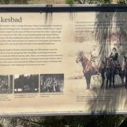
The trail to Bumpass Hell is a little lengthy, but is fairly easy for almost all skill levels. The entirety of the trail is beautifully scenic, with panoramic mountain views, including a perfect view of Mt Lassen across a lake at one point. Bumpass Hell is an interesting place with bubbling mud pots and plenty of educational material about the geothermal action going on in the area... It is a little stinky though. The story behind how Bumpass Hell got its name is interesting too... A cowboy named Kendall Van Hook Bumpass went stumbled on the area while looking for lost cattle. I think if my name was "Bumpass," I'd consider changing my name... But maybe that wasn't such a funny name back in the 1800s. Anyway, the "stumbled" part is quite literally--poor guy fell in one of the steaming mud pots and ended up losing his leg. That's where the "Hell" part of the name comes from. Anyway, it's a fun and interesting place now! One of the best parts of Lassen Volcanic National Park.

If you're looking for a quick, educational hike in Lassen that will surely freak out the kids, Bumpass Hell is that hike! A 3-mile out-and-back with only 300 ft. of elevation gain makes this a great one for anyone in reasonable hiking shape. Lassen's description of the hike: "Moderate hike over rocky terrain with grand vistas. The trail drops into an active hydrothermal basin where you can view mudpots and fumaroles. For your safety, please stay on the boardwalk. This trail often has snow hazards through July and into August." If you want to cut the boring part of the hike off, park at Lake Helen and hop on the trail right before the vistas get good. Despite the generally rocky road, we actually had a great time trail running; it doesn't get especially crowded and people are polite enough to step aside. At a decent clip, we got it done in 1.5 hours with enough time to slowly browse through Hell. Prepare for a horrendous sulphur smell once you hit the crest of the hydrothermal area - a handkerchief or other face covering isn't a bad idea (no one will judge you). There are lots of educational placards that will help you understand this "hellish" landscape and the history behind its discovery - I recommend grabbing some quick pics of them if you don't want to stand around reading them (it's pretty smelly). :-P Above all, Lassen is a living volcano! Check out this hike for an easy way to sample all the views (and smells) the park has to offer. :-)

Trail is a moderate hike, not too steep with some rockiness. Tree cover is pretty abundant, but you should still bring a hat. The smell of sulfur is very clear at the vista point of the springs, but it's not nearly as pungent as that of Yellowstone and in fact, was almost mild when you arrived at "hell" below. Definitely pay attention to the colors of the sulfur, it's like live chemistry in action. Especially cool was the pyrite pool at the very end where iron mixed with the sulfur created a black pond with eerie black bubbles rising to the top.

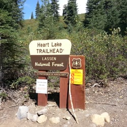
The Bumpass Hell Trail at Lassen National Park leads from a parking lot on Hwy 89 to the Bumpass Hell pits. There are amazing views of Lassen Peak, Lake Helen and the park along the way. The trail is moderately difficult and runs between 8200 - 8400 feet altitude. Bumpass Hell features boiling sulfur lakes, mud pots and steam vents. This is a must see when visiting Lassen. Plan for 2 hours round trip and bring plenty of water. There are no facilities along the trail.

Mr. Bumpass fell into some boiling mud right after explaining how dangerous it was in these parts. He was so severely burned that he lost that leg. The place is named "Hell" because that's what he thought of it. Now it's safe for you to go. They built nice walkways through the hot mud springs, or whatever you call them. It's really something, sort of colorful and desolate at the same time. It's stinky, too, like rotten eggs. Sulphur does that, I suppose.

One of my top two hikes in Lassen National Park, and probably their most popular and well-known hike. If you have the chance to hike down to Bumpass Hell, I'd highly recommend you do it. If you visited Sulphur Works, that's just a small bit of what Bumpass Hell has to offer. It's about a 3 mile round-trip hike with only about 200 elevation gain. All in all, it was a pretty easy hike. The views of these hot springs are absolutely gorgeous - a good variety of hydrothermal areas with such strikingly beautiful colors. If you've been to Yellowstone National Park, it might be a bit of a let down because the ones there are next level. So just keep that in mind when visiting! Make sure to stay on the boardwalk. The ground off trail is completely unpredictable and can lead to severe injuries. This trail is only open about 4 months of the year. So check the website in advance. It also gets so busy as this is their park gem. And there is not as much parking as you would like. So plan accordingly to ensure you'll be able to do the hike - the ranger did advise to go earlier in the morning. Amazing hike in Lassen. Highly recommend! read more


9 months ago
A Must-See Hike in Lassen Volcanic National Park! Bumpass Hell is a fantastic hike and one of the highlights of Lassen Volcanic National Park. The trail offers incredible geothermal features--bubbling mud pots, steaming vents, and vibrant colors that make it feel like you're walking through another world. Keep in mind, the hike is at high elevation, so the trail is typically only open from July through late October, depending on snow conditions. Please inform yourself before traveling here. In some years, it might not open until August - based on the information provided by rangers. Be sure to check trail conditions before you go, especially if Bumpass Hell is a must-do on your list. National Park fee applies. Even if the trail happens to be closed, don't worry--there are plenty of other great hikes throughout the park to explore. But if it's open, this one is absolutely worth the trip! If you happened to be fluffy like me, take it slow and drink water. read more


11 months ago
Bumpass Hell is the largest hydrothermal area in the park and marks the principal area of upflow of steam & discharge from the Lassen hydrothermal system. The temperature of high-velocity steam jetting from Big Boiler, the largest fumarole in the park, has been measured as high as 322°F, making it one of the hottest fumaroles in the world. You need to stay on the boardwalk, as the hydrothermal may give way underfoot, which may cause severe injuries. This place is named after Kendall Vanhook Bumpass, whom broke through a thin crust above a scalding hot mudpot. His leg was badly scalded & eventually had to be amputated. If you're looking for a good hike while visiting Lassen National Park, Bumpass Hell is a good one. It is long, and has some steep areas, but the views are gorgeous along the way. read more

5 years ago
6 years ago
Lassen National Park is other worldly! California has a very diverse geography, but when you think of California, you could not picture this in your wildest dreams. Bumpass Hell Trail will quite literally make you feel like you've gone through the forest and came out the other side on Mars. Stark white rock scapes accented by colorful mineral deposits greet you as you emerge from the trees. Muddy creeks filled with water warmed by the earth trickle along the surface, while ominous looking pools bubble in the background filling the air with a steamy foggy haze. The trail allows you to walk along a well maintained boardwalk that gets you close to this natural geothermal phenomenon. There are signs all over warning hikers to stay on the pathways, as the ground could give way, plunging you into potentially inescapable lava hot mud. That very thing happened to Mr. Bumpass, who guided early explorers through the area to see this for themselves. His accident is why the trail bears the name. All in all this is a relatively easy hike. About 2-3miles out and back with no serious inclines or declines and a very cool payoff. I'd say it's great for families and can be done in a very short time. The parking lot is decent, but if the park is busy, I could see it filling fast. read more


we ran out of time to hike this trail, but the view from the trailhead/vista point is absolutely gorgeous! i found a semi-secret rock to sit on and just relax and admire the view for a few moments...be careful though, b/c the rock could be a bit slippery and on a windy day, you could be blown into the valley! the trail is about 2 1/2 miles long (roundtrip) and rated as easy, so suitable for families with young children. the story goes, kendall bumpass, an early settler, was guiding some folks through this area and accidentally broke thru the surface of a geothermal area, and one of his legs was scalded from the steaming hot mudpot. ouch! now, there are guardrails and signs around these mudpots so that you can only look but not touch (and fall thru!) another gem in lassen nat'l park that is not to be missed! read more
Great wonder of the world. The home is moderate not to hard or easy. We walked a trail for about 500 feet which goes up and around the mountain. The trail is uphill 500 feet and then about 250 feet downhill and then you end up at the Bumpass Hell site. It's not as big of an area as I had thought we saw a few spurts coming out of the holes The trail was not to crowded we arrived at about 3pm it took us about an 2 Hours Total we are not advent hikers and do not walk period or exercise so the hike was a journey for us. You go up and around the mountain for a long time before you get to the bottom we almost gave up but kept on going. When we finally arrived it was a nice feeling to be in flat ground the pathway at the Bumpass path is a sturdy bridge platform that you can walk on and see a few of the earths wonders. Now the hike back was the hard part for us the 250 feet that was downhill in the way there is now an uphill thar you have to go back on that hill was much worst than the entire hike it was very HOT and my body wanted to die right there once we finally made it up that bottom hill the long uphill to get there is now a nice down around the mountain which was much easier than going. So all in all the trail back is worst than the walk there. Just do it and it's worth it read more


4 years ago
Very cool hike at Lassen National Park. Not to be missed since it's a one-of-a-kind trail that showcases the interesting geology of the area. The parking area is a few miles from the southwest entrance. It does fill up, however. Even on a Tuesday morning, I had to circle the lot to find a spot (I noticed, driving past it again around 4 pm, it had many more open spaces.) There are scenic views right from the lot, but you'll want to head up the trail for even more overlooks and the quintessential Lassen views. It's a well graded trail that inclines gently up through forested area, interspersed with rocky overlooks and a few small meadows. You'll reach the boardwalk area and head downhill to view the steam and boiling mud. It's an amazing landscape full of striking contrast and colors. It's an other worldly landscape for sure. On the way back up. I'd recommend taking the "Frying Pan" spur. It cuts a bit off the uphill and has some of the most spectacular views of the boardwalk area. There's a short uphill back out, before the trail levels out and then descends back to the lot. It's not super challenging but it's warm and open in that section. You can overheat on a summer day. It's a must do hike in Lassen and is about 3 miles round trip (with longer hikes that also can embark from here.) Lots of informational plaques and truly a wondrous hike. read more


5 years ago
8 years ago
The trail was closed during my visit in late May. However, the view from the parking lot was still lovely with all the snow. Looking forward to visiting Bumpass Hell again during the warmer season! read more


The trail to Bumpass Hell is a little lengthy, but is fairly easy for almost all skill levels. The entirety of the trail is beautifully scenic, with panoramic mountain views, including a perfect view of Mt Lassen across a lake at one point. Bumpass Hell is an interesting place with bubbling mud pots and plenty of educational material about the geothermal action going on in the area... It is a little stinky though. The story behind how Bumpass Hell got its name is interesting too... A cowboy named Kendall Van Hook Bumpass went stumbled on the area while looking for lost cattle. I think if my name was "Bumpass," I'd consider changing my name... But maybe that wasn't such a funny name back in the 1800s. Anyway, the "stumbled" part is quite literally--poor guy fell in one of the steaming mud pots and ended up losing his leg. That's where the "Hell" part of the name comes from. Anyway, it's a fun and interesting place now! One of the best parts of Lassen Volcanic National Park. read more

If you're looking for a quick, educational hike in Lassen that will surely freak out the kids, Bumpass Hell is that hike! A 3-mile out-and-back with only 300 ft. of elevation gain makes this a great one for anyone in reasonable hiking shape. Lassen's description of the hike: "Moderate hike over rocky terrain with grand vistas. The trail drops into an active hydrothermal basin where you can view mudpots and fumaroles. For your safety, please stay on the boardwalk. This trail often has snow hazards through July and into August." If you want to cut the boring part of the hike off, park at Lake Helen and hop on the trail right before the vistas get good. Despite the generally rocky road, we actually had a great time trail running; it doesn't get especially crowded and people are polite enough to step aside. At a decent clip, we got it done in 1.5 hours with enough time to slowly browse through Hell. Prepare for a horrendous sulphur smell once you hit the crest of the hydrothermal area - a handkerchief or other face covering isn't a bad idea (no one will judge you). There are lots of educational placards that will help you understand this "hellish" landscape and the history behind its discovery - I recommend grabbing some quick pics of them if you don't want to stand around reading them (it's pretty smelly). :-P Above all, Lassen is a living volcano! Check out this hike for an easy way to sample all the views (and smells) the park has to offer. :-) read more

 - Hiking Near Me")


Trail is a moderate hike, not too steep with some rockiness. Tree cover is pretty abundant, but you should still bring a hat. The smell of sulfur is very clear at the vista point of the springs, but it's not nearly as pungent as that of Yellowstone and in fact, was almost mild when you arrived at "hell" below. Definitely pay attention to the colors of the sulfur, it's like live chemistry in action. Especially cool was the pyrite pool at the very end where iron mixed with the sulfur created a black pond with eerie black bubbles rising to the top. read more


4 years ago
The Bumpass Hell Trail at Lassen National Park leads from a parking lot on Hwy 89 to the Bumpass Hell pits. There are amazing views of Lassen Peak, Lake Helen and the park along the way. The trail is moderately difficult and runs between 8200 - 8400 feet altitude. Bumpass Hell features boiling sulfur lakes, mud pots and steam vents. This is a must see when visiting Lassen. Plan for 2 hours round trip and bring plenty of water. There are no facilities along the trail. read more


Mr. Bumpass fell into some boiling mud right after explaining how dangerous it was in these parts. He was so severely burned that he lost that leg. The place is named "Hell" because that's what he thought of it. Now it's safe for you to go. They built nice walkways through the hot mud springs, or whatever you call them. It's really something, sort of colorful and desolate at the same time. It's stinky, too, like rotten eggs. Sulphur does that, I suppose. read more


15 years ago
11 years ago
Once again Mother Nature did not disappoint. The majority of the trail is a dirt/rocky path. As you get closer to the hydrothermal area, the trail becomes a wooden walkway over the steaming pools. The trail is about 3 miles total and took us (2 adults, 2 kids) almost 2 hours. The multi colored soils that is created by the different minerals was beautiful to see. read more


9 years ago
10 years ago
9 years ago
10 years ago
12 years ago
More info about Bumpass Hell Trail
Mineral, CA 96061
Directions
Hours
Outdoor Amenities
Ask the Community - Bumpass Hell Trail
Are there places to park an RV nearby the trailhead? We are planning to stay at Volcano Country Mineral RV Park and wish to drive to Bumpass Hell and do the trail.
The parking lot can accommodate RVs, but it all depends on how large yours is!
Review Highlights - Bumpass Hell Trail


Why does Yelp recommend reviews?
1 review that is not currently recommended
The reviews below are not factored into the business's overall star rating.
13 years ago
Bumpass Hell Trail - hiking - Updated June 2026
Best of Mineral
People found Bumpass Hell Trail by searching for…
Trending Searches in Mineral, CA
Browse Articles
Browse Nearby
BEST of Mineral, California Things to Do near Bumpass Hell Trail
BEST of Mineral, California Parks near Bumpass Hell Trail
BEST of Mineral, California Restaurants near Bumpass Hell Trail
BEST of Mineral, California Coffee near Bumpass Hell Trail
BEST of Mineral, California Breakfast near Bumpass Hell Trail
BEST of Mineral, California Hot Springs near Bumpass Hell Trail
BEST of Mineral, California Swimming Holes near Bumpass Hell Trail
BEST of Mineral, California Campgrounds near Bumpass Hell Trail
BEST of Mineral, California Visitor Centers near Bumpass Hell Trail
Browse Brands
Related Searches in Mineral, CA
Affordable Long Term RV Parking in Mineral, California
Best Fishing Locations and Guides in Mineral, California
Best Nature Trails for Hiking in Mineral, California
Best Places for Horseback Riding in Mineral, California
Best Places for Stunning Views in Mineral, California
Check Out Off Road Trails in Mineral, California
Discover Popular Bike Trails in Mineral, California
Discover Scenic Creeks to Explore in Mineral, California
Discover Scenic Mountain Bike Trails Near Mineral, California
Discover Top Nature Parks to Visit in Mineral, California
Discover a Hiking Trail in Mineral, California
Discover the Best Night Hike Trails in Mineral, California
Discover the Best Running Track in Mineral, California
Dog-Friendly Hikes With Dogs in Mineral, California
Enjoy Camping Adventures Around Mineral, California
Enjoy the Best Picnic Spots and Ideas in Mineral, California
Enjoy the Best Walking Trails in Mineral, California
Experience Stunning Sunset Views in Mineral, California
Explore Beautiful Parks and Green Spaces in Mineral, California
Explore Easy Hikes Perfect for All in Mineral, California
Explore Free Picnic Areas Around Mineral, California
Explore Nature Spots Around Mineral, California
Explore Parks With Pull Up Bars in Mineral, California
Explore Popular Boat Charters Near Mineral, California
Explore Popular Campgrounds Near Mineral, California
Explore Popular RV Parks Around Mineral, California
Explore Popular Scenic Overlook Points in Mineral, California
Explore Scenic Lakes to Visit in Mineral, California
Explore Secret Spots Worth Visiting in Mineral, California
Explore the Best Swimming Holes Around Mineral, California
Explore the Best Trail Options in Mineral, California
Family Friendly Hiking With Kids in Mineral, California
Find Beautiful Views in Mineral, California
Find Cozy Camping Cabins in Mineral, California
Find Parks and Recreation Activities in Mineral, California
Hiking Trails With Waterfalls in Mineral, California
Locate a Public Shower Facility in Mineral, California
Off Leash Dog Hiking Trails in Mineral, California
Perfect Spots to Watch Sunset in Mineral, California
Plan Nature Center Visits in Mineral, California
Plan a Scenic Drive Route Near Mineral, California
Popular Fishing Spots to Explore in Mineral, California
Popular Things to Do in Mineral, California
Relax at Natural Hot Springs Near Mineral, California
Safe River Swimming Areas in Mineral, California
Top Fishing Charter Experiences in Mineral, California
Top RV Campgrounds to Visit in Mineral, California
Top Running Trails to Explore in Mineral, California