Cancel

    Open app

    Search

    Overlook Trail

    5.0 (1 review)

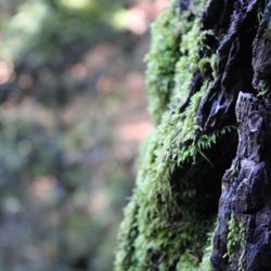
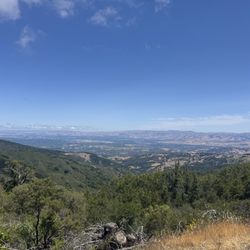
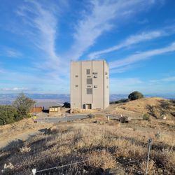
    Overlook Trail Photos

    You might also consider

    Recommended Reviews - Overlook Trail

    Your trust is our priority, so businesses can't pay to alter or remove their reviews. Learn more about reviews.
    Yelp app icon
    Browse more easily on the app
    Review Feed Illustration
    Photo of Sunil R.
    1125
    10314
    35649

    4 years ago

    Helpful 5
    Thanks 0
    Love this 2
    Oh no 0

    You might also consider

    Verify this business for free

    People searched for Hiking 7,199 times last month within 15 miles of this business.

    Verify this business

    Bear Creek Redwoods Preserve

    Bear Creek Redwoods Preserve

    4.3(32 reviews)
    3.5 mi

    The 6.2-mile 1000 feet of elevation is now my new favorite local trail, especially having recently…read morewatched Hamnet, the scenery felt strangely cinematic, as if certain moments--especially the cave entrance--had been lifted directly from the film. In Hamnet, the cave stands as a symbol of that mysterious realm of death, the void from which we come and to which we ultimately return. Yet on this beautiful sunny afternoon, as life breathes through every tree, every leaf, and every small flower, and as I feel the gentle care and encouragement of those beside me, I realized, not in a limbo zone way, that the world, exactly as it is, is beautiful enough. Heaven must be even better. https://youtube.com/shorts/xiQGHA3WKrY?si=womdxeGsiEBLsH0W

    Underbear Newish…read more±1,400-acre Open Space Preserve that's located only three-mikes south of Los Gatos, and is one of the few places in the area left to see Old-growth Redwoods. The Good: *Free! *One of the newer OSPs, as it officially opened in ±2019 *Fairly large paved parking lot that holds ±30 vehicles, including three ADA parking spots. There's a separate parking lot at the stables, but you need a permit. *Over ten miles of hiking trails *ADA Compliant trail around the pond in the parking lot. *Horses OK (check trail signage) *Picnic tables in the parking lot *As mentioned above, one of the few places in the South Bay that you can view old-growth Redwoods that doesn't require you to drive down to Felton (Henry Cowell) or Big Basin. *If you're looking for a challenge, the Upper Peter Siemens Trail-Madrone Knoll Trail has an elevation gain of ±1,500' over ±3.5 miles The Meh: *No dogs/pets The Ugly: *Restrooms in the parking lot, but I believe they were vault toilets--don't look down! 0_o Conclusion: Great place to get your hike on if you're in the South Bay and don't feel like a terribly long drive.

    Photos
    Bear Creek Redwoods Preserve - Bridge

    Bridge

    Bear Creek Redwoods Preserve
    Bear Creek Redwoods Preserve

    See all

    Castle Rock State Park

    Castle Rock State Park

    4.6(429 reviews)
    5.9 mi

    Have long eyed the Castle Rock State Park and glad we finally went! The park charges a nominal…read moreparking fee ($10 at time of writing); the parking fee is waived if you have one of the supported passes. Check their site for more info: https://www.parks.ca.gov/?page_id=538# We really enjoyed our hike here. The space is beautiful, and the trails are well-maintained. The trailhead had plenty restrooms as well. We made it up to Goat Rock Lookout, back down, then detour to the waterfall. It took ~1.5 hours in total, which was perfect for a end-of-day hike before the park closes at sunset. The view up at Goat Rock Lookout was breathtaking!

    If you're looking for another place that has breathtaking views surrounding the whole Santa Cruz…read moreMountains (but don't want to go all the way to Portola Valley), Castle Rock State Park is the place for you. This place is usually my go to when the weather is just perfect and you want good views of the mountains viewing the Monterey Bay and the Santa Clara Valley. In addition, the park is even open during the cold winter season, where it occasionally will snow (because of how high the elevation is, the main base is situated at about 3,200 feet above sea level). This place has been my go-to park for hiking for a while, because of its terrain. At the same time, it's also been because of how much snow they get when cold fronts come into effect. They are also open year-round, so definitely swing by this state park when you do get the chance to! It's a decision you'll never regret.

    Photos
    Castle Rock State Park - Love it

    Love it

    Castle Rock State Park
    Castle Rock State Park

    See all

    Sierra Azul Open Space Preserve - #AzulPreserve #AzulHiking #HikingBayArea #HikingCalifornia

    Sierra Azul Open Space Preserve

    3.9(38 reviews)
    4.6 mi

    Came here for a hike on the Sunday of Memorial Day weekend! Arrived at the Bald Mountain parking…read morelot around 8:30am and there were lots of spots still available. I went on the Mount Umunhum out and back trail. Still pretty green with some wildflowers! There were a decent amount of hikers, and lots of bicyclists. Seems like a very popular spot for mountain bikers! Had to watch out for cyclists most of the hike. Along the trail, there were some informational posts about the mountain's history and at the summit, there was a neat informational site, Native American pow wow example, and good balcony for pictures. Learned that Umunhum has that name because the Natives thought it sounded like a hummingbird! Partially shaded but I still recommend going in the morning. There were lots of switchbacks so the hike felt long - took me around 3 hours and 15 minutes including breaks to complete. When I came back around 11:45am, the parking lot was full and some people were parked on the side of the road. Overall, I would classify the Mount Umunhum trail as moderately difficult. Because of the switchbacks, the incline is very gradual but the hike feels longer. Good views and trails were well-maintained with markers. The constant cyclists slightly detracted from the hiking experience, but I would still recommend!

    Did the Mt Umunhum trail. Mostly shaded. Free parking. Great views. Some historical stuff (WW2…read moreradar builing and Native American religious site) at the top which is a nice reward making it to the top. Can drive all the way to the top if mobility is an issue.

    Photos
    Sierra Azul Open Space Preserve - #AzulPreserve #AzulHiking #HikingBayArea #HikingCalifornia

    #AzulPreserve #AzulHiking #HikingBayArea #HikingCalifornia

    Sierra Azul Open Space Preserve - #AzulPreserve #AzulHiking #HikingBayArea #HikingCalifornia

    #AzulPreserve #AzulHiking #HikingBayArea #HikingCalifornia

    Sierra Azul Open Space Preserve - #AzulPreserve #AzulHiking #HikingBayArea #HikingCalifornia

    See all

    #AzulPreserve #AzulHiking #HikingBayArea #HikingCalifornia

    Lexington Reservoir County Park - Lexington Reservoir County Park

    Lexington Reservoir County Park

    4.3(63 reviews)
    3.0 mi

    I have come here countless times over the years. It's one of my favorite spots. It's peaceful, not…read moreoverly crowded, and has a really calming, almost zen feel to it. The views of the water and surrounding hills make it a great place to reset for a bit. Perfect for a quiet walk, light hike, or just getting away from the noise for a while.

    Who Gives a Dam?…read more Man-made reservoir in the Santa Cruz Mountains that spans a solid 338-acres and is the third-largest in Santa Clara County. It is situated inside a ±950-acre County Park that has a variety of activities for all manner of outdoor lovers. The Good: *The southerly "beginning" to the Los Gatos Creek Trail which runs for ±10miles to the north. *Rowing, paddling, and fishing are all allowed (after proper inspections and licensing ofc) *Picnic tables near the reservoir *Limekiln trail was mostly shaded, which is good because this are can get very warm in the summer. *Park trails connect to Sierra Azul OSP and St Joseph's Hill OSP *Mountain bikes (NOT electric!) are OK *Leashed dogs are permitted. *Fairly decent cell phone signal (at least where we were) The Meh: *Parking is $6 if you park inside the lot, but free if you use the "street" parking (pay attention to signs!) or small dirt lots near the trailheads. *In regards to the parking, you don't need to park in the lot unless you're going to use/visit the reservoir itself. Otherwise, just find where your trail is and park there. *No swimming The Ugly: *We did the Limekiln Trail and that was a little rough-&-ready in some areas, as the years of water damage and infrequent maintenance are starting to take their toll.

    Photos
    Lexington Reservoir County Park - Lexington Reservoir County Park

    Lexington Reservoir County Park

    Lexington Reservoir County Park - Lexington Reservoir County Park

    Lexington Reservoir County Park

    Lexington Reservoir County Park - Lexington Reservoir County Park

    See all

    Lexington Reservoir County Park

    Saratoga Quarry Park

    Saratoga Quarry Park

    4.3(21 reviews)
    2.1 mi

    First hike of 2025 was here, and I'm really glad that I was able to come here. Big shoutout goes to…read morethe City of Saratoga and Public Works for keeping these trails open even on official holidays like today, on New Year's Day. There are endless amounts of trails that you can look towards -- some roll around in a circle, and some lead all the way to Sanborn County Park. While many people say these trails go nowhere, they do lead to the opening of trails that lead into the Santa Cruz Mountains. The only improvement that I would give to this park is the narrowness of some of the trails that we had to encounter -- and while there were spectacular views of the South Bay, what was lackluster and disappointing was the fact that there were barely any labels that were telling us where we were going. The bridges were a very good view of how close or how far we were from the very beginning of the entrance of the park, however, so that was a very good sign. If you're looking for a park that challenges you as much as going to Almaden Quicksilver Park, but without driving so far, then the Saratoga Quarry Park is just for you. I'll definitely be back to challenge myself to climb these hiking paths more.

    Great place for a rest stop, there is a men and women's bathroom as soon as you drive in. They have…read morea cool old structure that was part of area where they quarried the rocks with cool pictures inside of the " tunnel structure" There are also walking trails here "not really for me as I like hiking more on riverbed boulders, and things like that. Bottom line "for me this is a good place for a quick rest stop or a picnic.

    Photos
    Saratoga Quarry Park
    Saratoga Quarry Park
    Saratoga Quarry Park

    See all

    Overlook Trail - hiking - Updated May 2026

    Loading...
    Loading...
    Loading...