
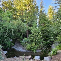
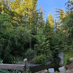
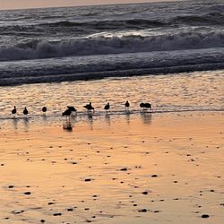
Mount Umunhum Photos


You might also consider
More like Mount Umunhum
Recommended Reviews - Mount Umunhum
Start your review...

Reviews With Photos


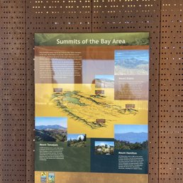
I still cannot believe there are less than 30 reviews and no reviews on the other site. There's not a lot of information so hopefully my experience can help. Throughout Santa Clara Valley, you can see the big box atop the mountain. I have always wanted to go to Mount Umunhum and finally got some friends to go with me. The drive is about an hour from San Jose to the top. The drive was pretty easy for me and there were no other cars, so I took my time driving safely to the top. I think the drive on Highway 17 is more crazier and more tough. So, there are 3 parking lots. The 1st parking lot is near the bottom and the hike is supposedly more than 10 miles roundtrip and will take several hours. We drove to the 2nd parking lot and found out from the park ranger that the hike is 4 miles, 8 miles roundtrip and would also take several hours. We didn't have a lot of time, so we went to the 3rd parking lot which is the closest to the tower. There is plenty of parking at the top with 2 options, the stairs or a 0.3 mile hike. My friends chose to do the short hike which has some incredible views and super easy. Once at the top, yes, you can see the Pacific ocean, Santa Clara Valley, San Jose, the hills, the mountains and much more. It can get pretty cold up there, about 10 degrees less than the Valley during the fall and winter. Bring a jacket during the colder months and some water and soap lol. There are bathrooms but there's no soap and water, so plan accordingly. You cannot go inside the tower but you can walk around it and it's very tall. There are signs explaining its history, maps and other information. I snapped some photos so I can read it when I got home. Don't forget to check out the area and check other the views along the top trail. Also, add an hour for the trip back. It would be easier to drive back down during sunlight because there are no lights along the roadway. Hope that helps and add Mount Umunhum to your South Bay bucketlist. Everything was alllllll freeee. Parking, admission and the awesome views.

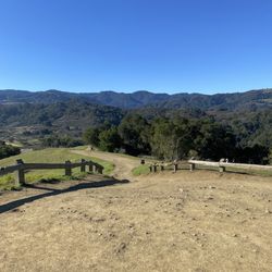
I was pleasantly surprised with the Mt Umunhum trail. There was plenty of parking and a total of 3 parking lots. I ended up parking at the last lot near the radar tower/cube building. There's stairs to go straight up to the cube itself or you can take the back trail route. Since I parked at the top, I decided to hike down the trail to the Guadalupe overlook. It took me about an hour down and an hour back up. The trail was nicely shaded for most of the hike and it was overall a good steady incline/decline. The view at the top was amazing! Pictures really don't do it justice. I definitely recommend this hike.

Phenomenal views, fairly easy (but long) hike. Great in the colder months. Pros: Mostly Easy terrain for walking. Aside from a small stretch of rocks heading up to the summit, the trail is a decent width (wasn't uncomfortable to have bikers pass by) and mostly just even, well maintained dirt path and very gentle, steady incline. A good portion is shaded in the winter. Not stressful hike - saw older kids and elderly doing the hike. Beautiful views along the way and the summit has panoramic views of the hills. Cons: The drive in the last 10 minutes involves a lot of winding roads with blind hairpin turns, shared with bikers and narrow if your car is on the wider side. Drive with caution. Lot is pretty limited in spots, there were plenty at 9am this holiday week on a weekday, but it was full when we came out. Bathroom at trailhead is pretty gross but at least there is one. Pro tips: This trail is very exposed in portions. Summer might be uncomfortable. Some areas have rocky areas, so hiking boots recommended. Out and back was 3 hours for us (7.75 mi total)but at a fast clip few stops, plan for 3.5-4 hours round trip .

My husband and I went on a rainy day, I have grown up my whole life in the south side of San José looking up and wondering what it was like to go to the cube. And we finally pulled the trigger and went! It was not a bad drive at all even with the rain the roads weren't too scary and inclined pretty steadily. If you're going in the winter I think it goes without saying bring some LAYERS and make sure to go to the restroom before embarking on your journey because the restrooms as any public restrooms are DISGUSTING. That said as someone that didn't hike the trail there's not too much to see up there, and the view isn't that crazy tbh. But it's nice to get some fresh air and away for a bit so I'll give it some points for that. If you haven't checked it out check it out just for the sake of doing it, and being next to a part of history. I think now that I went I'm just left with the curiosity of what is inside the cube?????


Beautiful hiking trail! Highly recommend! - Level: moderate. - Length: 3.5-4 miles one way for about 8ish miles total to and fro - Views: amazing mountains, greenery, a variety of wild flowers - clean and well maintained - Parking: not enough in the main lot, but there are a few options before and after the main lot. Depending on where you park the overall length of the hike will vary. - Historic: with info boards about the history throughout. The hike starts uphill, but is not a steep climb. The climb up is well distributed across length of the trail making it very easily manageable and not as daunting. Once you reach up on top...there's amazing 360 views. Find a spot and relax for a few min. Close your eyes, take slow, deep breaths and feel the history and the peaceful, serene, calming vibes. Biking and horse riding is ok, but unfortunately, other furry friends/dogs not allowed. Absolutely love this hiking trail...must try! Will be back again soon!


Cold War era radar converted into a park. Ever since I was a child there was this large gray box sitting on a mountain top. I always wondered what it was for. A few years ago, it was converted into a park and I finally got to see it! Wow! There are great views here. You can see the Santa Clara Valley from Gilroy all the way to the City of San Francisco and Mount Tamalpais behind it (which interestingly enough was also the home of a radar during the Cold War). The giant gray box you can see from most of Santa Clara Valley was home to a Cold War era radar that would monitor the pacific ocean. After satellites took over the job of monitoring the airspace of the USA west coast states hugging the Pacific Ocean, the radar station was retired. It sat in limbo for a few decades until the powers that be agreed to convert it into a historical monument and nature reserve. This park is managed by the Midpeninsula Regional Open Space District. They do a great job fund raising and managing this important historical and nature reserve. The preserve is open until 30 minutes after sunset. The park rangers close all the gates after that so be sure you leave in time and don't get stuck overnight at the top of the mountain. Be prepared for all kinds of weather. It can be as mild as a baby's kiss up there and, on the flip side, it can hit 100+ degrees Fahrenheit and 120 mile-an-hour winds. It is up to mother nature what kind of mood she is in, so be prepared! Bring drinking water, appropriate clothes, etc so whatever mood you she is in, you can maintain your comfort.

I definitely recommend this hike! If you want to do a long hike, you can park at the Jacques ridge lot (can be full since it's kind of small) and either walk up the road for about 1.7 miles to hit the Mt. Umunhum trailhead or take the much longer route via the Wood's trail. However, there is another bigger lot higher up near the Mt. Umunhum trail head where I parked. It's around 3.4 miles one way to the summit from there. You can just choose to drive all the way up too if hiking isn't your thing! Both parking lots have restrooms. The walk from the lower parking lot is quite steep initially but levels out later. From the Mt. Umunhum trail head is a gradual climb, some parts are shaded with trees, some are a bit exposed. Overall, its an easy hike. There were a few hikers and bikers on the trail. The summit offers really magnificent views. At the top there is a place to sit in the shade and relax for a bit, read more about the area/building and walk around. It was very windy and cold when we went so make sure you have a light jacket and a hat etc.
Came here to hike from Bald Mountain Parking Area up to Mt. Umunhum. All Trails says it's 7.7 miles. Strava says 8.51 miles. Close enough. It is a beautiful non-strenuous hike. EG is approximately +/- 1200 ft. With all the zigzag trails, i didn't notice it being 1200 ft EG. I did get tired towards the end. It's the last part with the stairs, . There are some parts of the trail that is only wide enough for one person to pass. Hiking poles are recommended. Make sure your devices are fully charged so you can take selfie's and scenic pictures. At top, there is a shelter. I did not see restrooms there but later found out after hiking back down and drove up , the restrooms are on the parking lot side. It's a different scenery when driving up. Take pictures (have the passenger take pictures) lol. The road up is curvy and narrow. Some people enjoy driving fast but highly not recommended. There are lots of bicyclists riding and you won't be able to see them around the bend. It was a bit chilly and windy at the summit. Bring sunscreen if you don't want to get sunburn. It was overcast the day i went but i did get sunburned. It's beautiful from start to finish. I enjoyed the hike very much and will return. Btw, bring picnic basket and enjoy the views. No tables but there are plenty of places you can sit. I definitely recommend this place. Cellular signal is limited.

Good workout with gradual incline. Start from the second parking located after Jacques ridge lot if you keen on doing 7.7 miles hike. 80% was shaded but avoid hot day if possible. The views are gorgeous and they also have picnic tables near the box building. The drawback for me personally was the windy road from hicks road onwards for about 5.3 miles. It was ok on a weekday to drive as there were no cars behind me so I could drive at the indicated speed limit. However if it's a weekend, I would expect a lot more traffic and that would make me nervous. The other strange thing I found was lots of shoes hanging on a rope near the stop sign and water reservoir. If anyone knows the mystery, please share.

Limited parking spot in Mt. Baldy parking area Paths are well maintained Brought 32 oz H2O for 8 mile round trip on a partly cloudy day and it was all gone! Great path to walk with kids, but just be weary of bicyclists Nice views of San Jose Thanks! read more


Have not been up here since I was a kid and wanted to check to see how it has changed. Well now it's a park and the military left, so it's been 45 years..... but the view is still gorgeous and a must see. Bay Area icon. Plus the drive is worth it. read more


Starting the first review of the year on a beautiful note. We visited Mt Umunhum this past weekend and it was simply lovely. The drive up was windy with great views. The top was equally beautiful with stunning views and we caught a great sunset! read more


2 years ago
I still cannot believe there are less than 30 reviews and no reviews on the other site. There's not a lot of information so hopefully my experience can help. Throughout Santa Clara Valley, you can see the big box atop the mountain. I have always wanted to go to Mount Umunhum and finally got some friends to go with me. The drive is about an hour from San Jose to the top. The drive was pretty easy for me and there were no other cars, so I took my time driving safely to the top. I think the drive on Highway 17 is more crazier and more tough. So, there are 3 parking lots. The 1st parking lot is near the bottom and the hike is supposedly more than 10 miles roundtrip and will take several hours. We drove to the 2nd parking lot and found out from the park ranger that the hike is 4 miles, 8 miles roundtrip and would also take several hours. We didn't have a lot of time, so we went to the 3rd parking lot which is the closest to the tower. There is plenty of parking at the top with 2 options, the stairs or a 0.3 mile hike. My friends chose to do the short hike which has some incredible views and super easy. Once at the top, yes, you can see the Pacific ocean, Santa Clara Valley, San Jose, the hills, the mountains and much more. It can get pretty cold up there, about 10 degrees less than the Valley during the fall and winter. Bring a jacket during the colder months and some water and soap lol. There are bathrooms but there's no soap and water, so plan accordingly. You cannot go inside the tower but you can walk around it and it's very tall. There are signs explaining its history, maps and other information. I snapped some photos so I can read it when I got home. Don't forget to check out the area and check other the views along the top trail. Also, add an hour for the trip back. It would be easier to drive back down during sunlight because there are no lights along the roadway. Hope that helps and add Mount Umunhum to your South Bay bucketlist. Everything was alllllll freeee. Parking, admission and the awesome views. read more


I was pleasantly surprised with the Mt Umunhum trail. There was plenty of parking and a total of 3 parking lots. I ended up parking at the last lot near the radar tower/cube building. There's stairs to go straight up to the cube itself or you can take the back trail route. Since I parked at the top, I decided to hike down the trail to the Guadalupe overlook. It took me about an hour down and an hour back up. The trail was nicely shaded for most of the hike and it was overall a good steady incline/decline. The view at the top was amazing! Pictures really don't do it justice. I definitely recommend this hike. read more


Phenomenal views, fairly easy (but long) hike. Great in the colder months. Pros: Mostly Easy terrain for walking. Aside from a small stretch of rocks heading up to the summit, the trail is a decent width (wasn't uncomfortable to have bikers pass by) and mostly just even, well maintained dirt path and very gentle, steady incline. A good portion is shaded in the winter. Not stressful hike - saw older kids and elderly doing the hike. Beautiful views along the way and the summit has panoramic views of the hills. Cons: The drive in the last 10 minutes involves a lot of winding roads with blind hairpin turns, shared with bikers and narrow if your car is on the wider side. Drive with caution. Lot is pretty limited in spots, there were plenty at 9am this holiday week on a weekday, but it was full when we came out. Bathroom at trailhead is pretty gross but at least there is one. Pro tips: This trail is very exposed in portions. Summer might be uncomfortable. Some areas have rocky areas, so hiking boots recommended. Out and back was 3 hours for us (7.75 mi total)but at a fast clip few stops, plan for 3.5-4 hours round trip . read more


3 years ago
2 years ago
My husband and I went on a rainy day, I have grown up my whole life in the south side of San José looking up and wondering what it was like to go to the cube. And we finally pulled the trigger and went! It was not a bad drive at all even with the rain the roads weren't too scary and inclined pretty steadily. If you're going in the winter I think it goes without saying bring some LAYERS and make sure to go to the restroom before embarking on your journey because the restrooms as any public restrooms are DISGUSTING. That said as someone that didn't hike the trail there's not too much to see up there, and the view isn't that crazy tbh. But it's nice to get some fresh air and away for a bit so I'll give it some points for that. If you haven't checked it out check it out just for the sake of doing it, and being next to a part of history. I think now that I went I'm just left with the curiosity of what is inside the cube????? read more


1 year ago
Beautiful hiking trail! Highly recommend! - Level: moderate. - Length: 3.5-4 miles one way for about 8ish miles total to and fro - Views: amazing mountains, greenery, a variety of wild flowers - clean and well maintained - Parking: not enough in the main lot, but there are a few options before and after the main lot. Depending on where you park the overall length of the hike will vary. - Historic: with info boards about the history throughout. The hike starts uphill, but is not a steep climb. The climb up is well distributed across length of the trail making it very easily manageable and not as daunting. Once you reach up on top...there's amazing 360 views. Find a spot and relax for a few min. Close your eyes, take slow, deep breaths and feel the history and the peaceful, serene, calming vibes. Biking and horse riding is ok, but unfortunately, other furry friends/dogs not allowed. Absolutely love this hiking trail...must try! Will be back again soon! read more


3 years ago
Well worth the drive up. Nice views and the quiet, you will savor the quiet. Interesting photo boards with the history of the place as well. read more

This is an incredible hike and with amazing views. Plus you can say Umunhum multiple times and I just love saying it...Umunhum. Say it with me...Umunhum. Don't let the mountain lion signs scare you away. It is well worth it. read more


Cold War era radar converted into a park. Ever since I was a child there was this large gray box sitting on a mountain top. I always wondered what it was for. A few years ago, it was converted into a park and I finally got to see it! Wow! There are great views here. You can see the Santa Clara Valley from Gilroy all the way to the City of San Francisco and Mount Tamalpais behind it (which interestingly enough was also the home of a radar during the Cold War). The giant gray box you can see from most of Santa Clara Valley was home to a Cold War era radar that would monitor the pacific ocean. After satellites took over the job of monitoring the airspace of the USA west coast states hugging the Pacific Ocean, the radar station was retired. It sat in limbo for a few decades until the powers that be agreed to convert it into a historical monument and nature reserve. This park is managed by the Midpeninsula Regional Open Space District. They do a great job fund raising and managing this important historical and nature reserve. The preserve is open until 30 minutes after sunset. The park rangers close all the gates after that so be sure you leave in time and don't get stuck overnight at the top of the mountain. Be prepared for all kinds of weather. It can be as mild as a baby's kiss up there and, on the flip side, it can hit 100+ degrees Fahrenheit and 120 mile-an-hour winds. It is up to mother nature what kind of mood she is in, so be prepared! Bring drinking water, appropriate clothes, etc so whatever mood you she is in, you can maintain your comfort. read more


I definitely recommend this hike! If you want to do a long hike, you can park at the Jacques ridge lot (can be full since it's kind of small) and either walk up the road for about 1.7 miles to hit the Mt. Umunhum trailhead or take the much longer route via the Wood's trail. However, there is another bigger lot higher up near the Mt. Umunhum trail head where I parked. It's around 3.4 miles one way to the summit from there. You can just choose to drive all the way up too if hiking isn't your thing! Both parking lots have restrooms. The walk from the lower parking lot is quite steep initially but levels out later. From the Mt. Umunhum trail head is a gradual climb, some parts are shaded with trees, some are a bit exposed. Overall, its an easy hike. There were a few hikers and bikers on the trail. The summit offers really magnificent views. At the top there is a place to sit in the shade and relax for a bit, read more about the area/building and walk around. It was very windy and cold when we went so make sure you have a light jacket and a hat etc. read more


4 years ago
Came here to hike from Bald Mountain Parking Area up to Mt. Umunhum. All Trails says it's 7.7 miles. Strava says 8.51 miles. Close enough. It is a beautiful non-strenuous hike. EG is approximately +/- 1200 ft. With all the zigzag trails, i didn't notice it being 1200 ft EG. I did get tired towards the end. It's the last part with the stairs, . There are some parts of the trail that is only wide enough for one person to pass. Hiking poles are recommended. Make sure your devices are fully charged so you can take selfie's and scenic pictures. At top, there is a shelter. I did not see restrooms there but later found out after hiking back down and drove up , the restrooms are on the parking lot side. It's a different scenery when driving up. Take pictures (have the passenger take pictures) lol. The road up is curvy and narrow. Some people enjoy driving fast but highly not recommended. There are lots of bicyclists riding and you won't be able to see them around the bend. It was a bit chilly and windy at the summit. Bring sunscreen if you don't want to get sunburn. It was overcast the day i went but i did get sunburned. It's beautiful from start to finish. I enjoyed the hike very much and will return. Btw, bring picnic basket and enjoy the views. No tables but there are plenty of places you can sit. I definitely recommend this place. Cellular signal is limited. read more


4 years ago
6 years ago
Good workout with gradual incline. Start from the second parking located after Jacques ridge lot if you keen on doing 7.7 miles hike. 80% was shaded but avoid hot day if possible. The views are gorgeous and they also have picnic tables near the box building. The drawback for me personally was the windy road from hicks road onwards for about 5.3 miles. It was ok on a weekday to drive as there were no cars behind me so I could drive at the indicated speed limit. However if it's a weekend, I would expect a lot more traffic and that would make me nervous. The other strange thing I found was lots of shoes hanging on a rope near the stop sign and water reservoir. If anyone knows the mystery, please share. read more


I recently hiked Mount Umunhum a few weeks ago with my fiancee. When parking at the lot on Mount Umunhum Road, it is 3.7 miles to the summit. The trail is very moderate, only a very mild incline the whole way up, which makes it perfect for a beginner hiker who is looking to start hiking mountains. The trail is well marked and has a good amount of shade and sun. Round trip hike was around 3 hours in length. The views from the top are incredible as it is one of the highest peaks in the Bay Area. On a clear day, you are able to see Mount Diablo, Mount Hamilton, and Mount Tam from the summit of Mount Umunhum. When hiking, plan on getting there early as the parking lot is pretty small and fills up fast. We were lucky to snag an empty spot at around noon on a Sunday. However, cars are always coming and going, so even if the lot is full, you probably won't wait very long for a spot to open up. There is also a parking lot at the summit if you prefer to just drive to the summit rather than hike it. I am definantly looking forward to more hikes here! read more


6 years ago
This is the patio where your able to hang out , even sit down on the bench and enjoy the phenomenal view after the long drive!! For this view you don't need to hike it just walk to it. There is parking right there but it's only for handicap vehicles or people getting dropped off. If you want to park your car and hang out, the parking lot is down the hill but it's quite a walk/hike(nothing difficult) there's even stairs to help. There's also bathrooms but those are currently closed. This place is very popular especially during sunset! So please expect the lot to be full especially during weekends. You drive on a winding road to get there a lot of curves with blind spots. A lot of people like to bike this road so please be considerate of them. The drive up is like 45 mins either entering from Hicks or almaden and that's my estimated guess without traffic. read more

Great place to go hiking/biking year round! If you go during the winter months, be sure to be prepared for the weather! For a nice hike during a sunny summer day, the trail up to the summit is perfect with plenty of shade. A San Jose favorite for my wife and I! I would try to get here early as the small parking lot at the base of the hiking trail fills up pretty quickly on a nice day. read more


Come here for some great views at sunset! It gets cold because of the elevation, so make sure you bring layers. We came in the winter so we drove instead of hiking (were worried it would get dark as we had a late start) - next time, we're determined to hike it. The roads are windy and long to get to the summit, but the signs are pretty clearly marked. Make sure you get a GPS signal before you go up so the signal persists even when it weakens (you can't initiate a signal when you're closer to the summit). read more

If I could design the perfect "casual" hiking trail that mixed a blend of accessibility, tranquility, scenery, and feasibility, I'd definitely mock up something like the out-and-back trail to Mount Umunhum in the Sierra Azul Open Space Preserve. My girlfriend and I took a stroll up there a couple weekends ago for our first hike of 2019, and it was definitely a great way to ease into the new year. Mount Umunhum, named by past Native Americans after the resting place of the hummingbird, is located along the Santa Cruz Mountain Range. It's quite easy to get there - about maybe a half hour to an hour drive from parts of the South Bay Area and the windy road to the trailhead was very well-maintained. You can either reach this sacred place via the summit parking area, which will just require you to climb a set of stairs. Or, you can hike the 7.5ish mile loop from the trailhead parking area. Even if you're a beginner hiker, I highly encourage trying out the trail for the reasons I've alluded to above. Although the total length might seem daunting, the trail itself was very manageable. It's a steady and often unnoticeable climb all the way up. The trail is well-paved and every half mile is marked. Even the slowest walkers will be able to get to the top and back in probably 5 hours (about 2 miles per hour). The hardest part was probably the climb up the stairs; there were roughly 160 steps to get you to the top. Overall, we felt extremely comfortable on the hike and it felt more like walking than anything. Throughout the hike, we saw an ever-changing landscape that brought on cool sights and sounds. There were manzanita trees everywhere, squirrels racing around, and a couple bridges that hung over crisp water. The coolest sight, besides the summit, was probably in the beginning where there's literally an abandoned buggy hanging from a ledge. You most likely won't see it on the way there, but during the return trip you'll find it on the left. My favorite memory from this hike was probably at the top when I heard this lady say in Cantonese, "there's nothing to see (or take pictures of) here!" It's all a matter of perspective, but imo she couldn't have been more wrong. The view from the summit was amazing! We got a 360 degree panorama of the Bay Area. If you're somewhat familiar with the Bay, you'll be able to spot some of the other summits on a clear day (e.g. Mount Tam, Diablo, etc.) Definitely check out the sacred circle too as well as the concrete building. You can't get close to the building because of possible radiation from past storms, but it's still cool; kinda reminds me of the building from the Belko Experiment. If you're looking for a great hike in the South Bay Area to break the rain, the trail to Mount Umunhum should be part of your list! You'll get a great workout that's rewarded with gorgeous views and a nice downhill return home. I give this an "Omg, I'd travel 2 hours for this" rating. Have fun and prosper, read more


7 years ago
Pretty cool spot with a great view. This is one of the highest peaks in the Bay Area. 6th to be exact, topping out at 3488'. It offers great views of the Silicon Valley and even a great view of the San Francisco skyline on a clear day. The drive is only 30 minutes from Los Gatos, but it's a slow go with all the twists and turns, and be extra cautious of cyclists climbing and descending. Don't let bad weather scare you off. Just go slow and be careful. During cold winter storms you may see snow. Plenty of parking and restrooms. Although I've never hiked there I see they have great trails too. read more


8 years ago
The curvy road to the top only takes 15 minutes and it's a beautiful drive. When you arrive, there are two parking lots. The first is limited but free and the second is a bit further uphill for the handicap only. Once you park, the various Vista views are spectacular! You can see all of silicon valley. They have plenty of benches for seating and a visitor center with lots of historical information. All of this is free! read more

 - Hiking Near Me")
4 years ago
I've hiked the trail up here a handful of times, and each time still amazes me just the same as the last. There's parking at 2-3 spots along the trail but on weekends you want to get there early before 9, as parking runs out at the bottom. It's a 4 mile hike up and 4 down that takes my friend and I from about 9am to before noon, depending on how long we are at the top taking pictures and looking around at the cube. By the time you reach the bottom to the stairs where the picnic tables are before heading to the cube, it's calm and usually warm but you should pack an extra sweater or something light in a backpack because my first time up there I was surprised by how windy it was from just a matter of steps up. If you plan on bypassing the hike altogether and just parking up top the walk is nearly nonexistent and bringing picnic stuff or something of the sort to sit at the picnic tables below is ideal, albeit they have no sinks there FYI. read more

7 years ago
6 years ago
7 years ago
More info about Mount Umunhum
Ask the Community - Mount Umunhum
Review Highlights - Mount Umunhum
You might also consider


Mount Umunhum - hiking - Updated July 2026
Best of San Jose
People found Mount Umunhum by searching for…
Great View Points in San Jose, CA
Abandoned Places in San Jose, CA
Places to Take Pictures in San Jose, CA
Scenic Places to Walk in San Jose, CA
Natural Hot Springs in San Jose, CA
Hang Out Places in San Jose, CA
Paved Walking Trails in San Jose, CA
Off Road Trails in San Jose, CA
Stair Climbing in San Jose, CA
Beautiful Views in San Jose, CA
Trending Searches in San Jose, CA
Blueberry Picking near Mount Umunhum
Cliff Jumping near Mount Umunhum
Cruising Spots near Mount Umunhum
Dog Friendly Things To Do near Mount Umunhum
Jet Ski Rental near Mount Umunhum
Kayak Rental near Mount Umunhum
Kids Activities Indoor near Mount Umunhum
Off Road Trails near Mount Umunhum
Outdoor Activities near Mount Umunhum
Peach Picking near Mount Umunhum
Places To Walk Around near Mount Umunhum
Public Shower near Mount Umunhum
River Swimming near Mount Umunhum
Rock Quarry near Mount Umunhum
Scenic Night View near Mount Umunhum
Scenic Overlook near Mount Umunhum
State Parks near Mount Umunhum
Swimming Holes near Mount Umunhum
Swimming Lakes near Mount Umunhum
Things To Do On A Rainy Day near Mount Umunhum
Watch Sunset near Mount Umunhum
Browse Articles
Browse Nearby
BEST of San Jose, California Restaurants near Mount Umunhum
BEST of San Jose, California Coffee near Mount Umunhum
BEST of San Jose, California Things to Do near Mount Umunhum
BEST of San Jose, California Breakfast near Mount Umunhum
BEST of San Jose, California Wineries near Mount Umunhum
BEST of San Jose, California Campgrounds near Mount Umunhum
BEST of San Jose, California Thrift Stores near Mount Umunhum
Browse Brands
Related Searches in San Jose, CA
Affordable Kayak Rental Services in San Jose, California
Best Dog Hiking Trails Around San Jose, California
Best Fishing Locations and Guides in San Jose, California
Best Nature Trails for Hiking in San Jose, California
Best Places for Horseback Riding in San Jose, California
Check Out Off Road Trails in San Jose, California
Discover Dog Friendly Trails to Explore in San Jose, California
Discover Easy Hiking Trails Near San Jose, California
Discover Kid Friendly Hiking Trails in San Jose, California
Discover Popular Bike Trails in San Jose, California
Discover Scenic Mountain Bike Trails Near San Jose, California
Discover Walking Parks in San Jose, California Near You
Discover a Hiking Trail in San Jose, California
Discover the Best Night Hike Trails in San Jose, California
Dog-Friendly Hikes With Dogs in San Jose, California
Enjoy Camping Adventures Around San Jose, California
Enjoy Kayaking Adventures in San Jose, California
Enjoy Off Leash Dog Hikes in San Jose, California
Enjoy Scenic Places to Walk in San Jose, California
Enjoy Tent Camping Spots Around San Jose, California
Enjoy a Beautiful Waterfall Hike in San Jose, California
Enjoy the Best Walking Path in San Jose, California
Enjoy the Best Walking Trails in San Jose, California
Explore Beautiful Parks and Green Spaces in San Jose, California
Explore Easy Hikes Perfect for All in San Jose, California
Explore Fun Activities to Do in San Jose, California
Explore Popular Campgrounds Near San Jose, California
Explore Popular Dog Walking Trails in San Jose, California
Explore Top Dog Parks in San Jose, California Near You
Explore the Best Beach Spots in San Jose, California
Family Friendly Hiking With Kids in San Jose, California
Find Parks and Recreation Activities in San Jose, California
Find Top Dog Friendly Parks to Visit in San Jose, California
Find Top-Rated Waterfalls in San Jose, California Now
Find the Best Parks for Picnics in San Jose, California
Hiking Trails With Waterfalls in San Jose, California
Off Leash Dog Hiking Trails in San Jose, California
Popular Outdoor Activities to Try in San Jose, California
Popular Picnic Spots to Visit in San Jose, California
Popular Waterfall Hiking Trails in San Jose, California
Safe River Swimming Areas in San Jose, California
Safe and Fun Parks for Kids in San Jose, California
Top Hiking Trails to Explore in San Jose, California
Top Playgrounds for Kids to Enjoy in San Jose, California
Top Running Trails to Explore in San Jose, California
Top Swimming Lakes to Enjoy in San Jose, California
Top Swimming Spots and Pools in San Jose, California
Top-Rated Camping Sites in San Jose, California


