Ouray Perimeter Trail Photos


More like Ouray Perimeter Trail
Recommended Reviews - Ouray Perimeter Trail
Start your review...


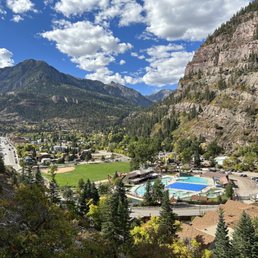
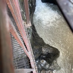
Did the entire Perimeter Trail the other day...clocked 6.2 miles in just under 4 hours. Started in the am at the trailhead located in the parking lot across from the Ouray Visitor's Center (which I highly recommend). You'll understand as you begin your final descent. As you start your initial ascent and climb the wood stairs into the hillside, enter the cliff path...a .8 mile slightly narrower trail than I'd prefer and a drop-off...but hey, the views are stunning! You can see the Ouray Hot Springs and more! As you keep on trekkin' on you'll start to "hear" before you make it to the gorgeous Cascade Falls!!! Chill, explore...even hike up behind the falls if that's your thing! I think I was pretty "ok" until we passed through the tunnel after the upper Box Canyon Bridge. We almost took a bail-out trail back into town along the way but persevered. There are actually a few bail-outs along the trail. Anyway, there were some sketchy narrow, steep, rocky-dusty-slidy, drop-off sections along the trail that gave me the heebie-jeebies. If you have a fear of heights, this may not be for you. For the majority of hikers out there I'm sure it's easy, but nonetheless make sure you go prepared. 1. Depending on what time you hike, be sure to eat a healthy meal before you go and bring some extra snacks just in case. 2. Signage isn't the best and is lacking "you are here", so I'd recommend taking a photo of the trail map before you head out. 3. Staying properly hydrated is key along the trail. If you've got a camelback that's great! 4. Take breaks when needed and don't feel pressured by any of your overzealous hiking buddies...it's supposed to be fun, safe and not a competition. 5. A walking stick or trekking poles can prove very helpful! Many people leave sticks at the trailhead(s). If you use one be sure to leave it behind for the next person. 6. Wear appropriate shoes for hiking. Yeah some peeps can hike in Croc's or Chaco's, but not highly recommended. Enjoy the trail, be safe, and take some pix! The views are beautiful! Be Happy Outside! read more


 - Hiking Near Me - Ridgway, Colorado")

This is a must do hike, plan to take about 5 hours or more if you take side trips. You will have great views of the city, mountain ranges on all sides, Canyon views, waterfalls, an aspen grove, a tunnel, various bridges, some narrow heart pumping areas on the west side, and views of the rock climbers along the via Ferrata read more


4 years ago
Bottom Line: A six mile trail that circumnavigates the town of Ouray and offers amazing views of the town and surrounding mountains. Ouray's signature hiking trail is the Perimeter Trail which is about a six mile trail that goes around the entire town. Even though it is a loop trail there are many places in town from which you can access the trail so its easy to just hike sections of it. Also, given there are various access points its easy to hop off the trail and walk to get a bite to eat in town. I think of the town as the hubs the access points of the spokes and the trail as the wheel. The main loop of the trail is elevated about the town and from what I can tell most access points to the six mile loop start with a steep-ish climb. We decided to start the trail at Cascade Falls and we climbed the first 1/4 mile before things leveled out a bit. Because the terrain is challenging and steep in places good hiking shoes and trekking poles are recommended by the non-profit group that manages the trail. I only hiked a section of the trail and didn't have trekking poles but I can see why they are recommended. The scenery on the trail includes the town, San Juan Mountains and various waterfalls. Along the way there are various bridges to cross and I particularly enjoyed the "Baby Bathtubs" section which is a a series of little tiny pools that are connected to make up a unique waterfall. I hear in the summer kids love to play in the little pools and I think I would too! A good place to park to hike the entire trail is behind the Ouray Visitor Center at 1230 Main Street, There is a large parking lot without any time restrictions and the trail is accessible off of the parking lot. But really you can park anywhere in town since none of the parking (except for in front of the post office) seems to have time restrictions and there are multiple trailheads. All Trails rates the trail as moderate and says it takes a bit over three hours to complete. But I believe the non-profit who manages the trail estimates four to five hours to complete the entire six mile loop. Elevation is around 8,500 feet around sea level and for me who lives at 120 feet above sea level I definitely found the climbs to be challenging but I'm glad I was able to do some of the trail with my limited time in Ouray. read more


3 years ago
This trail was so beautiful! 6 mile trail that goes around the town of Ouray. Lots of stunning views. read more


Great trail, beautiful fall color in late September. There are bailout points in needed. if you do shorten the route you do you might want to skip the stretch between the 4J+1+1 RV park an the Ouray Hot Spring/Visitors Center, and start just across 550 from the visitors center. read more


10 months ago
2 years ago
More info about Ouray Perimeter Trail
Ask the Community - Ouray Perimeter Trail


Ouray Perimeter Trail - hiking - Updated July 2026
Best of Ridgway
People found Ouray Perimeter Trail by searching for…
Trending Searches in Ridgway, CO
Browse Articles
Browse Nearby
BEST of Ridgway, Colorado Restaurants near Ouray Perimeter Trail
BEST of Ridgway, Colorado Parks near Ouray Perimeter Trail
BEST of Ridgway, Colorado Coffee near Ouray Perimeter Trail
BEST of Ridgway, Colorado Things to Do near Ouray Perimeter Trail
BEST of Ridgway, Colorado Waterfalls near Ouray Perimeter Trail
BEST of Ridgway, Colorado Caves near Ouray Perimeter Trail
BEST of Ridgway, Colorado Campgrounds near Ouray Perimeter Trail
BEST of Ridgway, Colorado Breakfast near Ouray Perimeter Trail
BEST of Ridgway, Colorado Hot Springs near Ouray Perimeter Trail
Browse Brands
Related Searches in Ridgway, CO
Affordable Kayak Rental Services in Ridgway, Colorado
Best Fishing Locations and Guides in Ridgway, Colorado
Best Fun Things to Do in Ridgway, Colorado
Best Nature Trails for Hiking in Ridgway, Colorado
Best Places for Horseback Riding in Ridgway, Colorado
Best Sledding Spots and Fun in Ridgway, Colorado
Check Out Off Road Trails in Ridgway, Colorado
Discover Popular Bike Trails in Ridgway, Colorado
Discover Popular Photo Spots in Ridgway, Colorado
Discover Scenic Waterfall Spots in Ridgway, Colorado
Discover a Hiking Trail in Ridgway, Colorado
Dog-Friendly Hikes With Dogs in Ridgway, Colorado
Enjoy Camping Adventures Around Ridgway, Colorado
Enjoy Exciting Mountain Biking Adventures in Ridgway, Colorado
Enjoy Kayaking Adventures in Ridgway, Colorado
Enjoy Tent Camping Spots Around Ridgway, Colorado
Enjoy the Best Picnic Spots and Ideas in Ridgway, Colorado
Experience Stunning Sunset Views in Ridgway, Colorado
Explore Beautiful Parks and Green Spaces in Ridgway, Colorado
Explore Bike Rentals Throughout Ridgway, Colorado
Explore Easy Hikes Perfect for All in Ridgway, Colorado
Explore Free Things to Do Around Ridgway, Colorado
Explore Fun Activities to Do in Ridgway, Colorado
Explore Popular Campgrounds Near Ridgway, Colorado
Explore Popular RV Parks Around Ridgway, Colorado
Explore Popular Scenic Overlook Points in Ridgway, Colorado
Explore Popular View Points Around Ridgway, Colorado
Explore Scenic Lakes to Visit in Ridgway, Colorado
Explore Top Dog Parks in Ridgway, Colorado Near You
Explore the Best Boating Spots in Ridgway, Colorado
Find Cozy Camping Cabins in Ridgway, Colorado
Find Fun Things to Do With Kids in Ridgway, Colorado
Find Popular Ziplining Spots Around Ridgway, Colorado
Find the Best Parks for Picnics in Ridgway, Colorado
Find the Best Playgrounds to Visit in Ridgway, Colorado
Find the Best Swimming Pools in Ridgway, Colorado Today
Great Places to Swim in Ridgway, Colorado
Hiking Trails With Waterfalls in Ridgway, Colorado
Locate a Public Shower Facility in Ridgway, Colorado
Plan a Scenic Drive Route Near Ridgway, Colorado
Popular Fishing Spots to Explore in Ridgway, Colorado
Popular Kids Activities in Ridgway, Colorado
Popular Things to Do in Ridgway, Colorado
Relax at Natural Hot Springs Near Ridgway, Colorado
Safe and Fun Parks for Kids in Ridgway, Colorado
Top Climbing Spots and Gyms in Ridgway, Colorado
Top Paddleboarding Activities in Ridgway, Colorado
Top Playgrounds for Kids to Enjoy in Ridgway, Colorado