Cancel

    Open app

    Search

    Last Dollar Road

    5.0 (2 reviews)

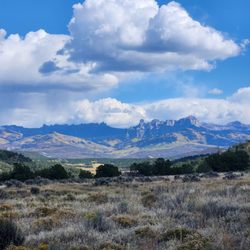
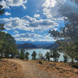
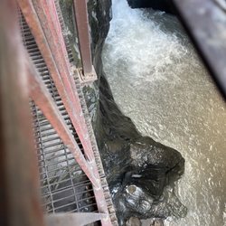
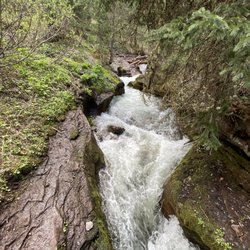
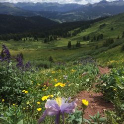
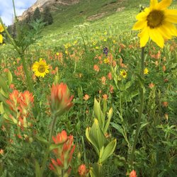
    Last Dollar Road Photos

    Recommended Reviews - Last Dollar Road

    Your trust is our priority, so businesses can't pay to alter or remove their reviews. Learn more about reviews.
    Yelp app icon
    Browse more easily on the app
    Review Feed Illustration

    4 years ago

    Helpful 1
    Thanks 0
    Love this 2
    Oh no 0

    3 years ago

    Beautiful views and easy access! It's a great spot to stop and take a walk.

    Helpful 0
    Thanks 0
    Love this 0
    Oh no 0

    Verify this business for free

    Get access to customer & competitor insights.

    Verify this business

    Handies Peak

    Handies Peak

    (4 reviews)

    Handies peak is a beautiful and easy class 1 in the San Juan's. My group and I did this one the day…read moreafter Redcloud & Sunshine, so it was nice to have a shorter day. It's less than 3K elevation and I clocked 6 miles round trip, granted the elevation builds quickly during those 3 miles to the summit. It was so beautiful that my two friends declared it was one of their top three favorite 14ers that they've done! The view at the top is stunning, with gorgeous scenery and breathtaking vistas along the way. You can make a very short detour and even visit a lovely alpine lake. The hardest part of the hike is accessing it. We were already parked along cimaron pass at our campsite, but it took an additional 40 minutes or so to drive from Redcloud trailhead to Handies. I made it in my Crosstrek but there were a couple of truly sketchy spots and a very very bumpy ride. No bathrooms at the trailhead and not much coverage to duck into the woods so keep that in mind. A must do for every 14er fanatic or ambitious hiker!

    Handies peak! I have dreamed about hiking this one for several years in the summer when…read morewildflowers are blooming but distance kept me away. Planned a 5 day stay up in the lake city/san juan area so we could knock it out. I finally did it and it did not disappoint. We took the Handies via grizzly gulch which is the non standard route and it is longer than the american basin route. The road getting to grizzly gulch from lake city was rough. lots of pot holes and jutting rocks. Also narrow stretches with drop offs on the side. ATVs and jeeps like to zip down the road at the speed of light and there are not a lot of pull offs along the way. I made it with my honda pilot but it was SLOW going. plan extra time for this road. (cimmaron pass) We were initially going to go to american basin but after the long drive to get to grizzly gulch i just didn't have it in me to do another 4-5 miles on even rougher road. There is a bathroom at the Trailhead. There are no trash cans or dog poop bags however so be sure to pack out whatever you pack in (including your dog poop)! This trail is a class 1. Though that does not mean it is "easy" by any means. However we did enjoy the first half or little more of the trail that had dirt trails and step ups. The trail was very well maintained. Currently in july there are fields of lovely wildflowers that are so abundant and in a variety of colors. Also there is a stream for a chunk of it that you will walk near. As you ascend further up, it begins to get rocky and there is scree near the top. As you merge on to the peak, you will meet up with all the hikers from american basin standard approach which is substantially more. So the peak may seem a little crowded. On our trek, we only saw maybe 6 other people. The flowers along the way and then the view at the top was all breathtaking! So thankful to have finally gotten to complete this peak!

    Blue Lakes, Mount Sneffels

    Blue Lakes, Mount Sneffels

    (4 reviews)

    I was able to return to take Mount Sneffles which has been on my bucket list of 14ers. I ascended…read morevia the standard rout (not blue lakes) which starts from a different trailhead:the yankee boy basin. If you have a good car you can get to the outhouse easily. I did this in my Subaru Crosstrek and car camped overnight. The outhouse actually is functional and very nice! The standard route is about 6 miles round trip with over 3K elevation gain. You walk about 2 miles up the road, then go straight up a bunch of scree. It's not technical, but was daunting. I thought it would be worse going down than it was in reality. After this section, veer left up a fun class 2 scramble to the top of a gully. Then go left again right before the top to the famous V notch. Not as scary as I thought it would be although a very nice person was helpful with descending as it's best to go through backwards. Then there is a short class 3 scramble to the summit with beautiful and rewarding views. You can see the blue lakes and mountains as far as the eye can see. This is a very special mountain and I met lots of nice people at the top! Id highly recommend this hike for anyone progressing to class 3s as it's a fairly easy one.

    We ventured up Mount Sneffels last week. It is considered an "easy class 3" 14er. We opted to go…read moreup the standard route (south slopes) which starts at Yankee Boy Basin trailhead. However to get to the trailhead you will need 4WD nd high clearance vehicle. If you dont have that you will either need to park at the bottom of the road or at the lower lot. Exposure and rockfall potential is considerable. Route finding and commitment is moderate. From the lower lot parking lot, you would start at 11350 feet elevation and will end at 14150 feet elevation. From the lower lot, round trip length of this trail is 6 miles. This trail was tough. once you get to the actual trail head, you will have around .5 mile of okay trail and then 1.2 miles of lots of scree and loose rock. You need to bring a helmet for this hike. People can kick down rocks above you or they could just fall loose. Poles would also be highly recommended. I normally do not hike with poles (well ever) and i was wishing i had them for this hike. My knees actually hurt on this one on the way down. It was one of the most challenging experiences i have completed but it was extremely rewarding. The views from the top were like no other. It was undescribable. So amazing. My top peaks would be this one or uncompaghre, just be sure that you are up for the challenge as it is VERY physically challenging.

    Box Canyon Waterfall and Park - View of the canyon sky from inside box canyon

    Box Canyon Waterfall and Park

    (78 reviews)

    Truly magnificent. The lower trail is easy for all levels, it has stable footing and minimal…read moreelevation changes, yet still offers beautiful views of the creek, and waterfalls along steel walkways and short trail. There are also stairs to near bottom of the waterfall. The high bridge trail is much more challenging, although one can opt to only climb the stair portion for a better view of Ouray and a little cardio. At the top of the stairs there is a small shelter, if you're feeling the altitude at this point it's a good idea not to continue further, as the trail continues to climb and there are no stairs/structure. There is a cable above the trail in sections for stability, and cables below some sections for safety. I'd guess the top of the stairs is a little less than half way to the high bridge. The bridge is a very sturdy structure, over a steep narrow gorge, the views of Box Cañon, the creek, waterfall, and town below are breathtaking. There is a hallway-like tunnel on the far side of the bridge, which is part of the perimeter trail. It's low in some spots but walkable, and offers some shade and cooling after the climb. The trail was drub when we went, it would be significantly more challenging/difficult with any moisture or icy conditions.

    I had an awesome time visiting box canyon waterfall while in Ouray! I came with my husband and…read moretoddler children. They absolutely loved it! Great for all ages. The waterfall was a lot bigger than I thought it would be. It was super loud inside of the canon which made it all the more exciting. Check out both the lower and upper box canon falls trails. The lower falls trail gets very close to the waterfall, we were getting wet from the spray we were so close. The upper trail has a great view of Ouray and a fun bridge to cross that leads into a tunnel. It is $7 for each adult, but super seniors, military, and children under 4 are free! No dogs allowed in the park. I don't think the dogs would want to come anyway with the metal bridges and aggressively loud waterfall. If you are in Ouray in the summertime this needs to be on your itinerary!

    Engineer Mountain Trail

    Engineer Mountain Trail

    (3 reviews)

    This hike was suggested to me by several friends who went to school in the area. It is pretty easy…read moreto find and parking wasn't too horrible. As much hype as this trail got before we did it, I can tell you that we all agree that this might be our favorite hike in Colorado so far. The trail is so lush and covered in wild flowers, knowing that it could have been the time of year, too. I loved that a lot it went through wooded areas before opening up above the tree line. It seemed that once we got above the tree line that there were amazing views everywhere we looked. We saw some mountain bikers but the trail wasn't too crowded overall. The summit is just under 13,000 feet but it is a great hike to get out of Durango for the morning and then to enjoy the afternoon back in town. Here are the directions to get there: Head North on Hwy 550 past Purgatory toward Silverton. Coal Bank Pass is 35 miles north of Durango, 13.5 miles south of Silverton, on Route 550. There is a parking area and restroom facility on the east side of the road at Coal Bank Pass (but don't park there). Just north of that, turn onto a road on the west side(opposite the rest area) which goes to the Pass Creek TH in under 200 yards.Slow down after mile marker 56 (it's between mm 56 and 57), you will see a rest area on the right and about 30 yards from that there is a small dirt road on the left - turn in there. It is hard to see, so slow down. Park at the end of the road on the side of the cul-de-sac. You will see the trail head heading north, and start there. Make sure you have plenty of water, a sweatshirt, and some rain gear. It should take 4 hours to casually hike up and back.

    This trail is amazing, the wildflowers were incredible. It's a medium challenging trail up until…read morethe base of the mountain, then it's shale all the way to the top. Amazing views of mountain ranges even if you just make it to the fields. I went late July beginning of August and it was just the perfect temperature and I still can't get over all the wildflowers!

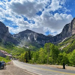
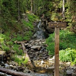
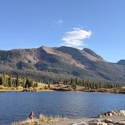
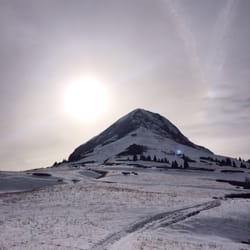
    Last Dollar Road - localflavor - Updated May 2026

    Loading...
    Loading...
    Loading...