North Fork Trail Photos


You might also consider
More like North Fork Trail
Recommended Reviews - North Fork Trail
Start your review...

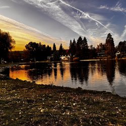
9 years ago
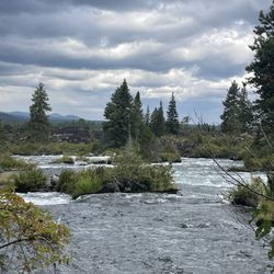
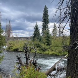
There is a good five feet or so of snow out here still. The snow pack is pretty weak and unstable. Your feet will randomly fall through the snow. I wouldn't head out unless you have a good pair of waterproof boots and support for your ankle. There are some slick spots here and there. The view is gorgeous, but it's pretty sketchy to get there. The gate to Tumalo Falls has not opened yet as well. So add a few extra miles to the journey... On the plus side, there's not as many people. :) read more


More info about North Fork Trail


North Fork Trail - hiking - Updated July 2026
Best of Bend
People found North Fork Trail by searching for…
Hiking Trails With Waterfalls in Bend, Oregon
Off Leash Dog Hiking Trails in Bend, Oregon
Swimming Lakes in Bend, Oregon
Mountain Bike Trails in Bend, Oregon
Fun Things to Do at Night With Kids in Bend, Oregon
Walking Trails in Bend, Oregon
Beautiful Views in Bend, Oregon
Dog Friendly Trails in Bend, Oregon
Tourist Attractions in Bend, Oregon
Things to Do With Teenagers in Bend, Oregon
Scenic Overlook in Bend, Oregon
Electric Bike Rental in Bend, Oregon
Lookout Points in Bend, Oregon
Trending Searches in Bend, OR
Browse Brands
Related Searches in Bend, OR
Affordable Bike Repair Services in Bend, Oregon
Affordable Cheap Bike Tune Up Services in Bend, Oregon
Affordable Kayak Rental Services in Bend, Oregon
Affordable Mobile Bike Repair in Bend, Oregon
Best Dirt Bike Riding Spots in Bend, Oregon
Best Dog Hiking Trails Around Bend, Oregon
Best Electric Bike Rental Services in Bend, Oregon
Best Fishing Locations and Guides in Bend, Oregon
Best Places for Horseback Riding in Bend, Oregon
Best Sightseeing Experiences Available in Bend, Oregon
Best Sledding Spots and Fun in Bend, Oregon
Best Waterfalls and Swimming Holes in Bend, Oregon
Check Out Off Road Trails in Bend, Oregon
Discover Dog Friendly Trails to Explore in Bend, Oregon
Discover Lakes & Ponds to Explore in Bend, Oregon
Discover Popular Bike Tours in Bend, Oregon
Discover Scenic Bike Paths in Bend, Oregon
Discover Scenic Mountain Bike Trails Near Bend, Oregon
Discover the Best Night Hike Trails in Bend, Oregon
Dog-Friendly Hikes With Dogs in Bend, Oregon
Enjoy Camping Adventures Around Bend, Oregon
Enjoy Hiking Adventures in Bend, Oregon
Enjoy Kayaking Adventures in Bend, Oregon
Enjoy Off Leash Dog Hikes in Bend, Oregon
Enjoy Tent Camping Spots Around Bend, Oregon
Enjoy Water Activities and Fun in Bend, Oregon
Enjoy the Best Tubing Experiences in Bend, Oregon
Enjoy the Best Walking Path in Bend, Oregon
Enjoy the Best Walking Trails in Bend, Oregon
Exciting Snow Tubing Experiences in Bend, Oregon
Experience Thrilling White Water Rafting in Bend, Oregon
Explore BMX Bike Shops Near Bend, Oregon
Explore Beautiful Parks and Green Spaces in Bend, Oregon
Explore Bike Rentals Throughout Bend, Oregon
Explore Easy Hikes Perfect for All in Bend, Oregon
Explore Electric Bikes Available in Bend, Oregon
Explore Fun Activities to Do in Bend, Oregon
Explore Mountain Bike Rentals Available in Bend, Oregon
Explore Popular Campgrounds Near Bend, Oregon
Explore Popular Scenic Views Near Bend, Oregon
Explore Scenic Lakes to Visit in Bend, Oregon
Explore Top Dog Parks in Bend, Oregon Near You
Explore Top Water Parks in Bend, Oregon Today
Explore the Best Beach Spots in Bend, Oregon
Explore the Best Rock Climbing Areas in Bend, Oregon