Deschutes River Trail System Photos


You might also consider
More like Deschutes River Trail System
Recommended Reviews - Deschutes River Trail System
Start your review...

Reviews With Photos

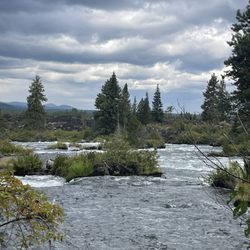
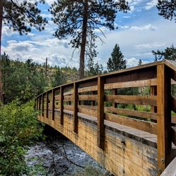
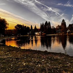
This was a highlight of our trip! What's better than being able to walk and explore without having to drive far outside the town. Right near downtown there are parks with parking lots and restrooms that connect to the trails. Simple maps show where you can go. We started in Riverbend Park and walked South. You immediately feel you're far away, but there are hints of homes along the ridges on both sides. The trails are kept well maintained; great for families, runners, or walking dogs. The entire length of the trail you're near the river so you can watch the rapids. Going this direction eventually the trail ends at a bridge to the other side; you can just walk the loop with plenty of other bridges back to wherever you started. There are also side trails into different neighborhoods; some are public and some are private. This is a great free and physical activity to do on your next trip to Bend. It's amazing for bird watching as well.

This is my favorite place to walk when I am visiting Bend. It's so beautiful and peaceful. The hike is easy, there are friendly people around and it's not too crowded surprisingly. There was a sign this time that said a cougar had been seen in the area but I didn't see it anywhere around thank goodness! If you have a chance please check it out, I think it's probably 3 miles but not sure.

It was a lovely evening, so after we ate an early dinner at a restaurant in Bend we decided to take a short hike along the trail at the Deschutes River. We encountered a good cross-section of other people who had the same idea. The overall experience was quite enjoyable and we were treated to some exceptional views of the river. The trail along the river is just over three miles long; the terrain is a dirt/sand path. Note that if you hike here you need to be aware that some of the terrain is quite rocky, and there are several spots that you'll have to climb fairly high when the trail is on the ascent. Be prepared for a moderate workout, and wear shoes that lend themselves to hiking. We actually saw several people trying to do the trail in flip-flops, and they were NOT happy campers!

It is important to note that the Deschutes River Trail is massive. Many of the reviews on here are only covering a small section of it. So this reviews will be a general overview of the whole trail system. I will be describing the other sections in separate review pages for this trail. I broke them down according to the way the land management agencies this trail runs through breaks them down on their websites. The sections from south to north are called Benham Falls East, Benham Falls West, Slough, Dillion Falls, Aspen, Big Eddy, Lava Island, South Canyon Reach, Old Mill Reach, Pioneer Reach, River Run Reach, Awbrey Reach, and the North Reach. Each section has its own unique qualities that are great for certain activities. This is a multi-use trail, you may often find bikers, hikers, and even some horseback riders on different sections of this trail. But it is important to note that not all sections of this trail are ideal for these activities. If you have caught Bend in May to September, then consider only trying to bike the North Reach, Dillon Falls, Aspen and Big Eddy sections, as there are so many hikers on this trail during these months that you will just create frustration and conflict by biking here. If you are hiking it really won't matter, just be sure to be polite and keep an eye out for other hikers looking to pass you. If you are not a fan of crowds, then you may want to consider other trails to hike from May to September, or you can also wait until the evening or morning when there are fewer people. This is my preferred method as even the out of town trails are getting more and more populated. Just watch out for mosquitos as this is the time that they like to escape the intense sun and bite you. Parking is different for each section here. The sections of the river that are in Bend city limits all have free parking. But the sections in the Deschutes National Forest require payments during the busy time of year. The sections that require payment are the Benham Falls East, Benham Falls West, Slough, Dillion Falls, Aspen, Big Eddy, Lava Island, and the sections that are free in town are the South Canyon Reach, Old Mill Reach, Pioneer Reach, River Run Reach, Awbrey Reach, and the North Reach. This is a great trail and you will have a five-star experience if you research ahead of time what section you will be on. Lastly, I will leave you with a few nice little easter eggs, there are several spots along this trail great for bouldering, Moutain bike features such as a pump track and even an archaeological hunting cave that dates back 7,000 years. Here are a few links to the land management agencies that this trail runs through. You will want to read the rules before heading out to avoid any tickets. Bend Parks and Rec http://www.bendparksandrec.org/parks__trails/trail_list/ Deschutes National Forest https://www.fs.usda.gov/recarea/deschutes/recarea/?recid=38338

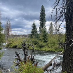
The Deschutes River Trail system is an extensive trail system running along the Deschutes River. It's paved in town but it's dirt when it enters the national forest. While it technically could be ridden on a mountain bike, it would probably be difficult to do so on weekends due to the number of people on the trail. It is better suited for hiking and trail running. In addition to those two options, it would be a great trail to hike with a fly rod and waders, dipping into the river to fish the good spots. We saw one guy flyfishing a hole when we were there. While many of the spots along the trail are a mere 30 minutes from bustling Bend, both the trail and views from the trail appear to be unobstructed by development and retain their natural beauty. There is a windy road that follows the river yet remains a few miles away from the actual river. From this road, you can choose from the multiple entrance points that lead directly to the river. The entrance points are not paved or grated. They implore the driver to drive carefully, or at least have a high clearance vehicle. This did not limit traffic to the small dirt parking lot at the Benham Falls Trailhead. We were fortunate to find a spot from a driver who had just left, but it was evident from all the locked bikes that many people park elsewhere and bike the two miles to the trailhead. There are multiple vantage points to see Benham Falls, which flow into more tranquil, yet still fast-moving sections of the river downstream. I believe there are more falls in the area, but there is not enough time for everything. The view across the river, downstream from Benham falls, shows large lava fields near the river with dense pine forest and mountains in the background.


One of the most picturesque trails you will ever see! Put on some comfortable clothes, sneakers (preferably by Oregon-based Nike), and take in the sights of happy paddle boarders and inner tubers on the Deschutes River. Keep your eye out for beautiful deer among the numerous pine trees too! So many great photo-ops along the route, especially on the overhanging cliffs. I recommend you cool yourself off like me at the end of your Neature Walk and take a dip in the river at the beach of Farewell Bend Park.

Fantastic river trail in the middle of the city. Most of the trail is parralel to the river with several access points. Fortunately, we were staying around the Old Mill District so we just jumped on the Loggers trail and connected to Deschutes River Trail. The trail is fairly easy and seemed to be a local favorite. It is probably about 3 miles in distance but an enjoyable activitity. While exploring, be sure to stop and read the information posted about the ecosystem of the area. If your are in Bend for work, come take a walk on this trail for some brainstorming or decompression you will be surprise what nature can do to you.

1 month ago
One of the Best Parts of Bend Was Right Outside Our Hotel While staying in downtown Bend, my family and I were looking for something outdoorsy and close by, and the Deschutes River Trail ended up being one of the highlights of our trip. What started as a casual morning walk quickly turned into a beautiful four-mile hike filled with rushing rapids, peaceful river bends, towering pine trees, and some incredible Central Oregon scenery. One of the best parts of this trail is how much the landscape changes as you go. At some points the river was calm enough for paddleboarders floating by, and at others the rapids were roaring against the rocks with serious energy and sound. The trail itself was also a nice mix. Some sections were smooth and paved, while others became a little more rugged with dirt paths, rocks, and small elevation changes that made the hike feel adventurous without being overly difficult. I would still consider this a very approachable hike for most people and fitness levels. We saw walkers, runners, families, and people out with their dogs enjoying the trail. Pro tip: bring water, especially on warmer days, because parts of the trail are fully exposed to the sun. Another thing I appreciated was how accessible this experience was from downtown Bend. We were able to walk straight from our hotel into what felt like a completely different environment surrounded by river, forest, and nature. We eventually wrapped up near the Old Mill District, which made for the perfect ending with shops, restaurants, and a chance to relax after the hike. Sometimes the best travel experiences are not the big tourist attractions, they are the simple moments outside on a trail reminding you why places like Bend are so special. read more


This hike hit all the spots. Easy to get to from downtown. You get a nice river view. You get a bridge. You get trees. You get sunlight if the weather is cooperating. You get a small park/playground area at one point and you get rocks and trees and nature and a few homes to look at too. Easy 3.5 miles walk around. read more


2 years ago
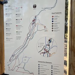
The Deschutes River Trail is super cool because you can walk, jog, or hike as far as you want. There are intermittent bridges where you can cross at different points. The landscape is beautiful because of all the shrubs with berries or the pretty flowering plants. The water in September is clean and clear. I didn't see any fish, but there were a few birds resting by the water banks. I liked that there were poles markers at different points showing the distance and a small map of the whole trail. read more


2 years ago
This was a highlight of our trip! What's better than being able to walk and explore without having to drive far outside the town. Right near downtown there are parks with parking lots and restrooms that connect to the trails. Simple maps show where you can go. We started in Riverbend Park and walked South. You immediately feel you're far away, but there are hints of homes along the ridges on both sides. The trails are kept well maintained; great for families, runners, or walking dogs. The entire length of the trail you're near the river so you can watch the rapids. Going this direction eventually the trail ends at a bridge to the other side; you can just walk the loop with plenty of other bridges back to wherever you started. There are also side trails into different neighborhoods; some are public and some are private. This is a great free and physical activity to do on your next trip to Bend. It's amazing for bird watching as well. read more


4 years ago
This is my favorite place to walk when I am visiting Bend. It's so beautiful and peaceful. The hike is easy, there are friendly people around and it's not too crowded surprisingly. There was a sign this time that said a cougar had been seen in the area but I didn't see it anywhere around thank goodness! If you have a chance please check it out, I think it's probably 3 miles but not sure. read more


5 years ago
It was a lovely evening, so after we ate an early dinner at a restaurant in Bend we decided to take a short hike along the trail at the Deschutes River. We encountered a good cross-section of other people who had the same idea. The overall experience was quite enjoyable and we were treated to some exceptional views of the river. The trail along the river is just over three miles long; the terrain is a dirt/sand path. Note that if you hike here you need to be aware that some of the terrain is quite rocky, and there are several spots that you'll have to climb fairly high when the trail is on the ascent. Be prepared for a moderate workout, and wear shoes that lend themselves to hiking. We actually saw several people trying to do the trail in flip-flops, and they were NOT happy campers! read more


9 years ago
It is important to note that the Deschutes River Trail is massive. Many of the reviews on here are only covering a small section of it. So this reviews will be a general overview of the whole trail system. I will be describing the other sections in separate review pages for this trail. I broke them down according to the way the land management agencies this trail runs through breaks them down on their websites. The sections from south to north are called Benham Falls East, Benham Falls West, Slough, Dillion Falls, Aspen, Big Eddy, Lava Island, South Canyon Reach, Old Mill Reach, Pioneer Reach, River Run Reach, Awbrey Reach, and the North Reach. Each section has its own unique qualities that are great for certain activities. This is a multi-use trail, you may often find bikers, hikers, and even some horseback riders on different sections of this trail. But it is important to note that not all sections of this trail are ideal for these activities. If you have caught Bend in May to September, then consider only trying to bike the North Reach, Dillon Falls, Aspen and Big Eddy sections, as there are so many hikers on this trail during these months that you will just create frustration and conflict by biking here. If you are hiking it really won't matter, just be sure to be polite and keep an eye out for other hikers looking to pass you. If you are not a fan of crowds, then you may want to consider other trails to hike from May to September, or you can also wait until the evening or morning when there are fewer people. This is my preferred method as even the out of town trails are getting more and more populated. Just watch out for mosquitos as this is the time that they like to escape the intense sun and bite you. Parking is different for each section here. The sections of the river that are in Bend city limits all have free parking. But the sections in the Deschutes National Forest require payments during the busy time of year. The sections that require payment are the Benham Falls East, Benham Falls West, Slough, Dillion Falls, Aspen, Big Eddy, Lava Island, and the sections that are free in town are the South Canyon Reach, Old Mill Reach, Pioneer Reach, River Run Reach, Awbrey Reach, and the North Reach. This is a great trail and you will have a five-star experience if you research ahead of time what section you will be on. Lastly, I will leave you with a few nice little easter eggs, there are several spots along this trail great for bouldering, Moutain bike features such as a pump track and even an archaeological hunting cave that dates back 7,000 years. Here are a few links to the land management agencies that this trail runs through. You will want to read the rules before heading out to avoid any tickets. Bend Parks and Rec http://www.bendparksandrec.org/parks__trails/trail_list/ Deschutes National Forest https://www.fs.usda.gov/recarea/deschutes/recarea/?recid=38338 read more


The Deschutes River Trail system is an extensive trail system running along the Deschutes River. It's paved in town but it's dirt when it enters the national forest. While it technically could be ridden on a mountain bike, it would probably be difficult to do so on weekends due to the number of people on the trail. It is better suited for hiking and trail running. In addition to those two options, it would be a great trail to hike with a fly rod and waders, dipping into the river to fish the good spots. We saw one guy flyfishing a hole when we were there. While many of the spots along the trail are a mere 30 minutes from bustling Bend, both the trail and views from the trail appear to be unobstructed by development and retain their natural beauty. There is a windy road that follows the river yet remains a few miles away from the actual river. From this road, you can choose from the multiple entrance points that lead directly to the river. The entrance points are not paved or grated. They implore the driver to drive carefully, or at least have a high clearance vehicle. This did not limit traffic to the small dirt parking lot at the Benham Falls Trailhead. We were fortunate to find a spot from a driver who had just left, but it was evident from all the locked bikes that many people park elsewhere and bike the two miles to the trailhead. There are multiple vantage points to see Benham Falls, which flow into more tranquil, yet still fast-moving sections of the river downstream. I believe there are more falls in the area, but there is not enough time for everything. The view across the river, downstream from Benham falls, shows large lava fields near the river with dense pine forest and mountains in the background. read more


6 years ago
10 years ago
Great trail for the scenery. It gets a bit busy during the summer, but the views are outstanding. The further up you go the more you are rewarded. Calm stretches of river are intermingled with rapids. Benham falls has a nice viewing terrace. read more


One of the most picturesque trails you will ever see! Put on some comfortable clothes, sneakers (preferably by Oregon-based Nike), and take in the sights of happy paddle boarders and inner tubers on the Deschutes River. Keep your eye out for beautiful deer among the numerous pine trees too! So many great photo-ops along the route, especially on the overhanging cliffs. I recommend you cool yourself off like me at the end of your Neature Walk and take a dip in the river at the beach of Farewell Bend Park. read more


Fantastic river trail in the middle of the city. Most of the trail is parralel to the river with several access points. Fortunately, we were staying around the Old Mill District so we just jumped on the Loggers trail and connected to Deschutes River Trail. The trail is fairly easy and seemed to be a local favorite. It is probably about 3 miles in distance but an enjoyable activitity. While exploring, be sure to stop and read the information posted about the ecosystem of the area. If your are in Bend for work, come take a walk on this trail for some brainstorming or decompression you will be surprise what nature can do to you. read more

8 years ago
9 years ago
We recently visited several parts of this trail system and enjoyed the beauty of it everywhere we visited. The areas we visited we still in a natural state, with mostly dirt trails carved into the natural landscape and following the river. Parking areas were clean and convenient, would be nice for sunny picnic lunches during the summer. There are several different places to access this vast trail system and parts are open to hikers, mountain bikes, and horses. We were camping in the forest area and we walked the trail portion between Big Eddy and Lava Island and mountain biked the Storm King trail from just below our camp to the Big Eddy area. We loved both the hiking and the mountain biking. In addition to the great scenery along the trail we saw river rafting groups and individual kayaks hit some good rapids near Big Eddy. I would encourage locals and people who travel to the Bend area to get out there and enjoy it! read more


10 years ago
More info about Deschutes River Trail System
63095 Deschutes Market Rd
Bend, OR 97701
Directions
Hours
Outdoor Amenities
Ask the Community - Deschutes River Trail System
Review Highlights - Deschutes River Trail System


Deschutes River Trail System - hiking - Updated June 2026
Best of Bend
People found Deschutes River Trail System by searching for…
Trending Searches in Bend, OR
Boat Rental near Deschutes River Trail System
Cliff Jumping near Deschutes River Trail System
Day Trips near Deschutes River Trail System
Dog Friendly Trails near Deschutes River Trail System
Dog Swimming near Deschutes River Trail System
Fishing Spots near Deschutes River Trail System
Kayak Rental near Deschutes River Trail System
Lakes & Ponds near Deschutes River Trail System
Outdoor Activities near Deschutes River Trail System
Pick Your Own Farms near Deschutes River Trail System
Public Shower near Deschutes River Trail System
River Swimming near Deschutes River Trail System
River Tubing near Deschutes River Trail System
Scenic Overlook near Deschutes River Trail System
Secluded Spots near Deschutes River Trail System
Soccer Store near Deschutes River Trail System
Splash Pad near Deschutes River Trail System
Sunrise View near Deschutes River Trail System
Swimming Holes near Deschutes River Trail System
Swimming Lakes near Deschutes River Trail System
Swimming Pools near Deschutes River Trail System
Browse Articles
Browse Nearby
BEST of Bend, Oregon Coffee near Deschutes River Trail System
BEST of Bend, Oregon Restaurants near Deschutes River Trail System
BEST of Bend, Oregon Breakfast near Deschutes River Trail System
BEST of Bend, Oregon Things to Do near Deschutes River Trail System
BEST of Bend, Oregon Walking Trails near Deschutes River Trail System
BEST of Bend, Oregon Parks near Deschutes River Trail System
BEST of Bend, Oregon Caves near Deschutes River Trail System
BEST of Bend, Oregon Hot Springs near Deschutes River Trail System
BEST of Bend, Oregon Campgrounds near Deschutes River Trail System
Browse Brands
Related Searches in Bend, OR
Affordable Kayak Rental Services in Bend, Oregon
Best Fishing Locations and Guides in Bend, Oregon
Best Places for Horseback Riding in Bend, Oregon
Best Places for Stunning Views in Bend, Oregon
Best Waterfalls and Swimming Holes in Bend, Oregon
Check Out Off Road Trails in Bend, Oregon
Discover Dog Friendly Trails to Explore in Bend, Oregon
Discover Scenic Mountain Bike Trails Near Bend, Oregon
Discover Scenic Waterfall Spots in Bend, Oregon
Discover a Hiking Trail in Bend, Oregon
Discover the Best Night Hike Trails in Bend, Oregon
Dog-Friendly Hikes With Dogs in Bend, Oregon
Enjoy Camping Adventures Around Bend, Oregon
Enjoy Exciting Mountain Biking Adventures in Bend, Oregon
Enjoy Kayaking Adventures in Bend, Oregon
Enjoy River Tubing Adventures in Bend, Oregon
Enjoy Tent Camping Spots Around Bend, Oregon
Enjoy a Beautiful Waterfall Hike in Bend, Oregon
Enjoy the Best Tubing Experiences in Bend, Oregon
Enjoy the Best Walking Trails in Bend, Oregon
Exciting Cliff Jumping Spots in Bend, Oregon
Experience Thrilling White Water Rafting in Bend, Oregon
Explore Beautiful Parks and Green Spaces in Bend, Oregon
Explore Bike Rentals Throughout Bend, Oregon
Explore Easy Hikes Perfect for All in Bend, Oregon
Explore Fun Activities to Do in Bend, Oregon
Explore Popular Campgrounds Near Bend, Oregon
Explore Popular Scenic Overlook Points in Bend, Oregon
Explore Scenic Lakes to Visit in Bend, Oregon
Explore the Best Beach Spots in Bend, Oregon
Explore the Best Boating Spots in Bend, Oregon
Explore the Best Swimming Holes Around Bend, Oregon
Family Friendly Hiking With Kids in Bend, Oregon
Find Beautiful Views in Bend, Oregon
Hike the Popular Waterfall Trail in Bend, Oregon
Hiking Trails With Waterfalls in Bend, Oregon
Off Leash Dog Hiking Trails in Bend, Oregon
Plan Nature Center Visits in Bend, Oregon
Popular Fishing Spots to Explore in Bend, Oregon
Popular Outdoor Activities to Try in Bend, Oregon
Popular Picnic Spots to Visit in Bend, Oregon
Popular Things to Do in Bend, Oregon
Safe and Fun Parks for Kids in Bend, Oregon
Top Climbing Spots and Gyms in Bend, Oregon
Top Playgrounds for Kids to Enjoy in Bend, Oregon
Top Running Trails to Explore in Bend, Oregon
Top Swimming Lakes to Enjoy in Bend, Oregon
Top Swimming Spots and Pools in Bend, Oregon
People who viewed Deschutes River Trail System also viewed
Central Oregon Historic Canal Trail
2 reviews
South Sister
8 reviews
Tam McArthur Rim Trail
2 reviews
Bessie Butte Trail
1 review
Tumalo State Park
46 reviews
Deschutes River Trail
3 reviews
Drake Park and Mirror Pond
62 reviews
Archie Briggs Canyon Trail
1 review
LaPine State Park
39 reviews
Cascade Highlands Trail
1 review