Mt Baldy Visitor Center Photos


You might also consider
More like Mt Baldy Visitor Center
Recommended Reviews - Mt Baldy Visitor Center
Start your review...

Reviews With Photos

We stopped off at the Mt Baldy Visitor Center early Saturday morning to purchase our $5 Adventure Pass. The woman who was working at the time was friendly and very helpful, providing us with maps and parking info for our hike that day. Others were purchasing permits for various different areas. A good spot to use an actual restroom.

27 days ago


6 years ago
A big shout out to the lady who works here during our visit in late Oct. 2019! (We should've asked her name) We usually come to Mt. Baldy for the snow, but this year, we decided to come for fall leaves and hiking. First off, we stopped at the visitor center for the parking pass. ($5 parking fee) The lady, who works there, was so informative and helpful showing us where to go, where has a better view point and all those other good suggestions! She even told us this location once was a school back in 1920s, it was also the first school they had in Mt. Baldy! The staff here def made us feel invited! Excellent service!! Some Tips: They have a actual bathroom in the visitor center. It's clean! Or else, there is a public toilet next to the parking lot, close to the entrance of hiking trials. (You can't wash your hands there) There is no WiFi in the mountains, so get yourself prepared for the route first! (Ask a map from them, screen shot your hiking routes!) read more


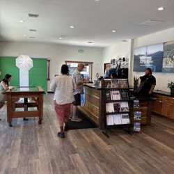
If you're heading over to hike Mt. Baldy or Cucamonga Peak you'll want to stop here first to make sure you have the proper parking pass Incase you don't have an adventure pass for the season (you can also purchase the adventure pass at Big 5 or REI). The parking pass is $5, if you park at the trail parking areas without a pass you might get a citation. The visitor center can give you information about the area and maps of the near by trails. When we stopped by we found out our friends annual National Park pass that he got when we went to Yosemite is also valid here so we didn't need to purchase an additional pass. The center only takes cash or check, & the hours they're open vary so you can call or check online for their hours. read more


3 years ago
11 years ago
We stopped off at the Mt Baldy Visitor Center early Saturday morning to purchase our $5 Adventure Pass. The woman who was working at the time was friendly and very helpful, providing us with maps and parking info for our hike that day. Others were purchasing permits for various different areas. A good spot to use an actual restroom. read more


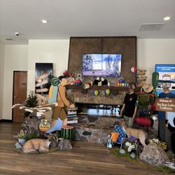
This is a nice pit stop on your way to Mt. Baldy Ski Resort. You won't need an Angeles National Forest Adventure Pass if you're planning to use the lifts. The resort will make you pay a $5.00 parking fee. The volunteers at this site are friendly and willing to provide education on the history of the area. Kids will get a kick out of the native wildlife on display inside the center. There are also displays of early Mt. Baldy settlers and another showcasing the mining history. They sell various souvenirs. If you see a t-shirt that you like I would just get it. The selection on the mountain is not much better. Outside there are some fun huts and other structures for the kids to explore and play in. read more


10 years ago
12 years ago
11 years ago
11 years ago
More info about Mt Baldy Visitor Center
Ask the Community - Mt Baldy Visitor Center
Review Highlights - Mt Baldy Visitor Center
You might also consider


Why does Yelp recommend reviews?
1 review that is not currently recommended
The reviews below are not factored into the business's overall star rating.
1 year ago
Mt Baldy Visitor Center - visitorcenters - Updated May 2026
Best of Mount Baldy
People found Mt Baldy Visitor Center by searching for…
Ski Lessons in Mount Baldy, CA
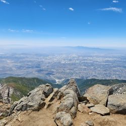
View Points in Mount Baldy, CA
Off Road Trails in Mount Baldy, CA
Transportation in Mount Baldy, CA
Tent Camping in Mount Baldy, CA
Picnic Areas in Mount Baldy, CA
Hotels & Travel in Mount Baldy, CA
Monthly Parking in Mount Baldy, CA
Nature Center in Mount Baldy, CA
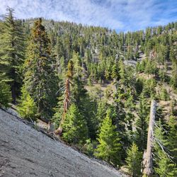
Hiking Trails in Mount Baldy, CA
Redwood Forest in Mount Baldy, CA
Travel Services in Mount Baldy, CA
Places to Take Pictures in Mount Baldy, CA
Places to Visit in Mount Baldy, CA
Sightseeing in Mount Baldy, CA
Browse Nearby
BEST of Mount Baldy, California Coffee near Mt Baldy Visitor Center
BEST of Mount Baldy, California Photo Spots near Mt Baldy Visitor Center
BEST of Mount Baldy, California Restaurants near Mt Baldy Visitor Center
BEST of Mount Baldy, California Star Gazing near Mt Baldy Visitor Center
BEST of Mount Baldy, California Hotels near Mt Baldy Visitor Center
BEST of Mount Baldy, California Things to Do near Mt Baldy Visitor Center
BEST of Mount Baldy, California Gold Panning near Mt Baldy Visitor Center
BEST of Mount Baldy, California Hiking near Mt Baldy Visitor Center
BEST of Mount Baldy, California Breakfast near Mt Baldy Visitor Center
Browse Brands
Related Cost Guides
Browse Articles
People who viewed Mt Baldy Visitor Center also viewed
Ontario Museum of History & Art
25 reviews
Spadra Cemetery
29 reviews
James Turrell Skyspace
7 reviews
Henninger Flats Visitor Center
4 reviews
Glendora Station
2 reviews
Coldbrook Campground
47 reviews
Crystal Lake Campground to Baden-Powell Hike
4 reviews
San Dimas Metro Station
3 reviews
Fairmount Cementary
4 reviews
San Gabriel Canyon OHV
7 reviews