Henninger Flats Visitor Center Photos


You might also consider
More like Henninger Flats Visitor Center
Recommended Reviews - Henninger Flats Visitor Center
Start your review...

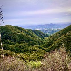
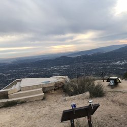
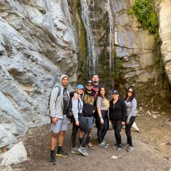
A mere three miles past the despair and human detritus that is the cavalcade of Eaton Canyon waterfall-bound imbeciles carrying Bluetooth speakers blaring DMX and coolers full of glass bottles that will be "deposited" in shards amidst the tagged and grafitti'ed rocks and trees, Henninger Flats is a much more peaceful representation of the San Gabriel mountains. Thankfully, the elevation gain involved in the short but steady uphill keeps the majority of idiocy far below. The hike itself is about three miles on the Mt. Wilson Toll Road, a wide dirt path with very little shade by midday. Just past the sign welcoming you to Henninger Flats, pine trees provide shade over picnic and camping areas. Pit toilets, a tree farm, a nature trail, and the nature center are also featured here. The visitor center is variably open most days, and has some historical and natural displays that are showing their age, but are still as interesting as they were when I was a kid coming up here with my dad. A soda machine offers cold drinks for a buck, but it only takes quarters. Be sure to sign the guestbook on the counter, and on the rare opportunity that someone is staffing the front desk, stop in and say hi. Note well: while a project is currently underway to bring potable water back to Henninger, as of September 2018, there is STILL NO DRINKING WATER AT HENNINGER. Bring plenty of drinking water, especially if you are continuing deeper into the mountains on a longer hike. Most of the times that I visit, there are Boy Scout group camping on the weekend. Camping is free here, but you need to reserve the spot. read more


If you want to visit this historic Visitor Center it's going to take a little effort. It is located high up in the San Gabriel Mountains, 2.6 miles from Eaton Canyon bridge. Henninger Flats is named after William Henninger who moved here from Virginia in 1880. There is a free camp ground located on the site with the same name. Inside the Visitor Center there are a number of displays that highlight the nature and the history of the location. There is a vending machine that sells cold drinks and a candy dispenser. The day I visited it was unmanned and the operating hours were not posted. Nearby there is an old miner's cabin, built in 1875, called Briggs Terrace. There is an historic Fire Lookout Tower from Castro Peak that was operational from 1925-1971. There is also nearby forest nursery and conservation center that provides trees for environmental projects throughout the County. There are 3 separate areas with restrooms; only one of them was open the day I visited. Behind the oldest bathroom is a spigot that dispenses high-flow water. I'm not entirely sure if it is potable but it was great for cooling off. To get there I recommend parking in the residential area somewhere near the corner of Cresent Dr and Pinecrest Dr.. From there you can walk up Pinecrest Dr where you will eventually see a chainlink fence. After you cross past the fence you will be on Mount Wilson Toll Rd.. Cross over Eaton Canyon bridge and head up the mountain. If you go in the morning you'll have partial shade, otherwise, if you go in the afternoon you will be largely sun-exposed. There are a number of benches along the trail where you can rest and take in the views. It's over 5 miles round-trip so bring lots of water and wear sunscreen. read more


More info about Henninger Flats Visitor Center
Mt Wilson Toll Rd
Altadena, CA 91001
Directions
Hours
Outdoor Amenities
Other Amenities
You might also consider


Why does Yelp recommend reviews?
1 review that is not currently recommended
The reviews below are not factored into the business's overall star rating.
7 years ago
Henninger Flats Visitor Center - hiking - Updated May 2026
Best of Altadena
People found Henninger Flats Visitor Center by searching for…
Free Campgrounds in Altadena, CA
Hiking Trails With Waterfalls in Altadena, CA
Visitor Centers in Altadena, CA
Horse Carriage Ride in Altadena, CA
Waterfalls and Swimming Holes in Altadena, CA
Travel Services in Altadena, CA
Free Things to Do in Altadena, CA
Scenic Places to Walk in Altadena, CA
Lookout Points in Altadena, CA
Hiking Trails Kid Friendly in Altadena, CA
Trending Searches in Altadena, CA
Boat Rental near Henninger Flats Visitor Center
Botanical Gardens near Henninger Flats Visitor Center
Bounce House Rentals near Henninger Flats Visitor Center
Campgrounds near Henninger Flats Visitor Center
Cherry Picking near Henninger Flats Visitor Center
Cliff Jumping near Henninger Flats Visitor Center
Dog Friendly Things To Do near Henninger Flats Visitor Center
Flower Fields near Henninger Flats Visitor Center
Flower Shop near Henninger Flats Visitor Center
Garage Sales near Henninger Flats Visitor Center
Hair near Henninger Flats Visitor Center
Lakes & Ponds near Henninger Flats Visitor Center
Nurseries & Gardening near Henninger Flats Visitor Center
Outdoor Activities near Henninger Flats Visitor Center
Outdoor Furniture Stores near Henninger Flats Visitor Center
Parks near Henninger Flats Visitor Center
Party Equipment Rentals near Henninger Flats Visitor Center
Pedicure near Henninger Flats Visitor Center
Pick Your Own Farms near Henninger Flats Visitor Center
Picnic Areas near Henninger Flats Visitor Center
Places To Take Pictures near Henninger Flats Visitor Center
Running Trails near Henninger Flats Visitor Center
Scenic Drive near Henninger Flats Visitor Center
Secret Spots near Henninger Flats Visitor Center
Strawberry Picking near Henninger Flats Visitor Center
Sunrise View near Henninger Flats Visitor Center
Swimming Holes near Henninger Flats Visitor Center
Table And Chair Rentals near Henninger Flats Visitor Center
Browse Articles
Browse Nearby
BEST of Altadena, California Coffee near Henninger Flats Visitor Center
BEST of Altadena, California Parks near Henninger Flats Visitor Center
BEST of Altadena, California Things to Do near Henninger Flats Visitor Center
BEST of Altadena, California Restaurants near Henninger Flats Visitor Center
BEST of Altadena, California Waterfalls near Henninger Flats Visitor Center
BEST of Altadena, California Breakfast near Henninger Flats Visitor Center
BEST of Altadena, California Campgrounds near Henninger Flats Visitor Center
BEST of Altadena, California Hotels near Henninger Flats Visitor Center
Browse Brands
Related Cost Guides
Related Searches in Altadena, CA
Best Fishing Locations and Guides in Altadena, California
Best Nature Trails for Hiking in Altadena, California
Best Places for Horseback Riding in Altadena, California
Best Sightseeing Experiences Available in Altadena, California
Best Waterfalls and Swimming Holes in Altadena, California
Book Exciting Sightseeing Tours in Altadena, California
Book a Dinner Cruise Experience in Altadena, California
Book a Mansion Tour in Altadena, California
Book a Trolley Tour Experience in Altadena, California
Check Out Off Road Trails in Altadena, California
Discover Architectural Tours Available in Altadena, California
Discover Charming Historic Homes in Altadena, California
Discover Dog Friendly Trails to Explore in Altadena, California
Discover Kid Friendly Hiking Trails in Altadena, California
Discover Popular Bike Tours in Altadena, California
Discover Scenic Hiking Trails in Altadena, California
Discover Scenic Mountain Bike Trails Near Altadena, California
Discover Scenic Waterfall Spots in Altadena, California
Discover Top Boat Tours in Altadena, California for All Ages
Discover Walking Parks in Altadena, California Near You
Discover a Hiking Trail in Altadena, California
Discover the Best Interactive Museum in Altadena, California
Discover the Best Night Hike Trails in Altadena, California
Discover the Best Running Track in Altadena, California
Discover the Best Sunset Cruise Tours in Altadena, California
Dog-Friendly Hikes With Dogs in Altadena, California
Enjoy Camping Adventures Around Altadena, California
Enjoy Exciting Mountain Biking Adventures in Altadena, California
Enjoy Hop on Hop Off Bus Tours in Altadena, California
Enjoy Kayaking Adventures in Altadena, California
Enjoy Tent Camping Spots Around Altadena, California
Enjoy a Beautiful Waterfall Hike in Altadena, California
Enjoy a Peaceful Nature Walk in Altadena, California
Enjoy the Best Walking Path in Altadena, California
Enjoy the Best Walking Trails in Altadena, California
Essential Tips for Every Tourist in Altadena, California
Exciting Cliff Jumping Spots in Altadena, California
Experience Thrilling Helicopter Rides in Altadena, California
Explore Beautiful Parks and Green Spaces in Altadena, California
Explore Easy Hikes Perfect for All in Altadena, California
Explore Free Things to Do Around Altadena, California
Explore Fun Activities to Do in Altadena, California
Explore Fun Field Trips in Altadena, California
Explore Historical Landmarks in Altadena, California
Explore Landmarks & Historical Buildings in Altadena, California
Explore Popular Campgrounds Near Altadena, California
Explore Popular Day Trips From Altadena, California
Explore Popular Ghost Tours Around Altadena, California
People who viewed Henninger Flats Visitor Center also viewed
Upper Chilao To Horse Flats
3 reviews
Josephine Peak
17 reviews
Hollywood Sign Hike
297 reviews
Hollywood Hills
Idlehour Trail Camp
5 reviews
Millard Falls Trailhead
1 review
Grassy Hollow Visitor Center
11 reviews
Mount Lukens Via Stone Canyon Trail
8 reviews
Grizzly Flats Trail
1 review
Eaton Canyon Falls Trail
13 reviews
Strawberry Peak
20 reviews