Mount Ord Photos


You might also consider
More like Mount Ord
Recommended Reviews - Mount Ord
Start your review...

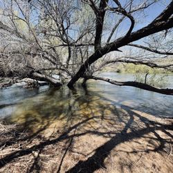
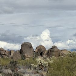
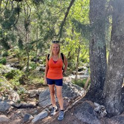
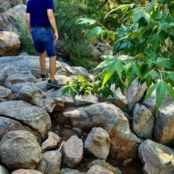
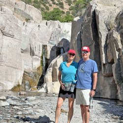
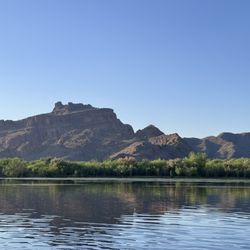
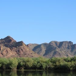
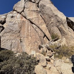
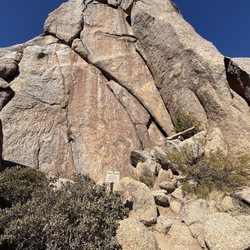
This is a great trail, it's about 60 minutes from Phoenix, the elevation change at the top makes this place about 20 - 30 degrees cooler than the valley, there are about two first come first served camp spots at the top. Once you park, there's a short 20 minute hike up to some radio towers with a wonderful view of the surrounding mountains and valleys. I've never camped here myself, but I usually see someone who drove in and is tent camping or camping out of a conversion van of some type. My most recent visit corresponded to a thunder storm in the valley, which meant it was a bit rainy on the hike up the trail. It's a relatively easy hike with some consistent elevation increase on the way up, you can do this hike in a pair of sneakers and a bottle of water. As far as the drive in, nothing too treacherous here, the road is passable by anything with four wheels and a driver with a bit of gumption. Four wheel drive and a high clearance vehicle is NOT required for this drive, but it certainly does make it easier to navigate. I definitely take air out of the tires for any dirt road and this is no exception; although, if you don't carry an air compressor in your vehicle, I'd suggest you don't let air out as there really isn't anywhere close by to put air back in. You can spend 5 minutes looking at the view or a couple hours. You can bring a picnic basket, your water bottle and a granola bar, or nothing at all - whatever you feel like on this excursion. It's a fairly easy destination and if you've been outside and walked more than a mile in one go within the past 6 months, this hike will be a piece of cake for you! read more


More info about Mount Ord
Unnamed Rd
Tonto National Forest
Rio Verde, AZ 85263
Directions
Hours
Outdoor Amenities
Other Amenities
You might also consider


Mount Ord - hiking - Updated June 2026
Best of Rio Verde
People found Mount Ord by searching for…
Scenic Night View in Rio Verde, AZ
Scenic Overlook in Rio Verde, AZ
Hiking Trails in Rio Verde, AZ
Romantic Picnic in Rio Verde, AZ
Lookout Points in Rio Verde, AZ
Public Shower in Rio Verde, AZ
Beautiful Views in Rio Verde, AZ
Camping Sites in Rio Verde, AZ
Off Road Trails in Rio Verde, AZ
Camping Cabins in Rio Verde, AZ
Rv Dump Station in Rio Verde, AZ
Browse Brands
Related Cost Guides
Related Searches in Rio Verde, AZ
Affordable Canoe Rental Options in Rio Verde, Arizona
Affordable Kayak Rental Services in Rio Verde, Arizona
Affordable Long Term RV Parking in Rio Verde, Arizona
Affordable RV Rental Options in Rio Verde, Arizona
Best Day Camps for Children in Rio Verde, Arizona
Best Fishing Locations and Guides in Rio Verde, Arizona
Best Places for Horseback Riding in Rio Verde, Arizona
Best Pontoon Boat Rentals Near Rio Verde, Arizona
Best Summer Camps for Kids Located in Rio Verde, Arizona
Best Waterfalls and Swimming Holes in Rio Verde, Arizona
Browse Top Hotels in Rio Verde, Arizona for Your Stay
Browse Vacation Rentals to Book in Rio Verde, Arizona
Check Out Off Road Trails in Rio Verde, Arizona
Discover Dog Friendly Trails to Explore in Rio Verde, Arizona
Discover Fun Toddler Parks in Rio Verde, Arizona for Your Little One
Discover Lakes & Ponds to Explore in Rio Verde, Arizona
Discover Scenic Waterfall Spots in Rio Verde, Arizona
Discover Top Scenic Spots to Visit in Rio Verde, Arizona
Discover Walking Parks in Rio Verde, Arizona Near You
Discover a Hiking Trail in Rio Verde, Arizona
Discover the Best Beaches in Rio Verde, Arizona
Discover the Best Night Hike Trails in Rio Verde, Arizona
Dog-Friendly Hikes With Dogs in Rio Verde, Arizona
Enjoy Camping Adventures Around Rio Verde, Arizona
Enjoy Exciting Mountain Biking Adventures in Rio Verde, Arizona
Enjoy Hiking Adventures in Rio Verde, Arizona
Enjoy Kayaking Adventures in Rio Verde, Arizona
Enjoy RV Camping Adventures in Rio Verde, Arizona
Enjoy River Tubing Adventures in Rio Verde, Arizona
Enjoy Tent Camping Spots Around Rio Verde, Arizona
Enjoy a Beautiful Waterfall Hike in Rio Verde, Arizona
Enjoy the Best Walking Path in Rio Verde, Arizona
Enjoy the Best Walking Trails in Rio Verde, Arizona
Exciting Cliff Jumping Spots in Rio Verde, Arizona
Experience Thrilling White Water Rafting in Rio Verde, Arizona
Explore Beautiful Parks and Green Spaces in Rio Verde, Arizona
Explore Easy Hikes Perfect for All in Rio Verde, Arizona
Explore Fun Activities to Do in Rio Verde, Arizona
Explore Hotels & Travel Options in Rio Verde, Arizona
Explore Mobile Home Parks in Rio Verde, Arizona Now
Explore Popular Campgrounds Near Rio Verde, Arizona
Explore Popular Picnic Areas Around Rio Verde, Arizona
Explore Popular Scenic Overlook Points in Rio Verde, Arizona
Explore Scenic Lakes to Visit in Rio Verde, Arizona
Explore Summer Camps for All Ages in Rio Verde, Arizona
Explore Top Dog Parks in Rio Verde, Arizona Near You
Explore Top Water Parks in Rio Verde, Arizona Today
Explore the Best Boating Spots in Rio Verde, Arizona