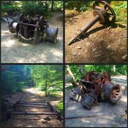
Mcdowell Creek Falls Photos


More like Mcdowell Creek Falls
Recommended Reviews - Mcdowell Creek Falls
Start your review...

Reviews With Photos


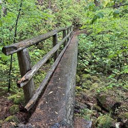
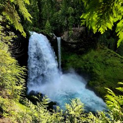
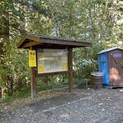
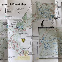
What a Beautiful Outdoor Experience!! McDowell Creek County Park is absolutely breathtaking in the Fall Season! It has beginner, intermediate, and difficult trails with 3 separate parking areas depending on where you want to start or what trail you want to hike. We will definitely be back to enjoy this gorgeous park and it's 3 waterfalls! It's clean and well-maintained. It has bathrooms in the parking lot, multiple picnic areas, sturdy bridges over waterways, and stone and wood stairs in multiple areas including leading up to two of its waterfalls. We saw many other nature lovers of all ages during our hike and several dogs. I would say the trail from the lower parking lot was on the higher moderate level as the stairs to the Royal Terrace Falls were a bit steep and some steps were more elevated than others.

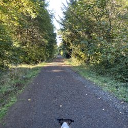
This park is a gem outside Lebanon. It is not super developed, but it is generally clean and the facilities are in good repair. The falls, this time of year are gorgeous. There's about 1.8 miles of trail to walk and three separate parking lots to use. There are a multitude of picnic tables for lunching or sitting around to visit. I spend many a Saturday morning out in the park, walking, reading, meditating... and visiting friends. It is a gorgeous park and one of my favorites within 50 miles of home.


3 months ago


9 months ago
2 years ago
This place is a gem for those wanting their nature bucket filled. From the sound of the waterfall, to the view of a healthy forest with mossy felt covered branches and large fern and shamrock ground cover to the feel of mist kissed skin. Also, the exercise feel so good on the body. read more


3 years ago
What a Beautiful Outdoor Experience!! McDowell Creek County Park is absolutely breathtaking in the Fall Season! It has beginner, intermediate, and difficult trails with 3 separate parking areas depending on where you want to start or what trail you want to hike. We will definitely be back to enjoy this gorgeous park and it's 3 waterfalls! It's clean and well-maintained. It has bathrooms in the parking lot, multiple picnic areas, sturdy bridges over waterways, and stone and wood stairs in multiple areas including leading up to two of its waterfalls. We saw many other nature lovers of all ages during our hike and several dogs. I would say the trail from the lower parking lot was on the higher moderate level as the stairs to the Royal Terrace Falls were a bit steep and some steps were more elevated than others. read more


This park is a gem outside Lebanon. It is not super developed, but it is generally clean and the facilities are in good repair. The falls, this time of year are gorgeous. There's about 1.8 miles of trail to walk and three separate parking lots to use. There are a multitude of picnic tables for lunching or sitting around to visit. I spend many a Saturday morning out in the park, walking, reading, meditating... and visiting friends. It is a gorgeous park and one of my favorites within 50 miles of home. read more


8 months ago
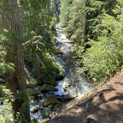
I just moved to Oregon recently, and I knew oregon is full of hiking trails and popular for outdoor activities. Coming from an urban/suburban area in SoCal, I never had the chance to experience nature, so I had no idea what to expect. Plus, I'm not physically fit either haha. This hike was my first one since moving, and at first it caught my attention because of the relatively short distance and amazing waterfalls. I went to check it out and it was not disappointing at all. It went beyond my expectation on how beautiful this place was. Everything was green and the water was so clear. It was a short hike but I took so long because I took a million pictures. Some pathways were a little narrow, but the app AllTrails helped me navigate well (would definitely recommend). There were some people on the hike but not crowded at all. There are some tables at the start of the trail so you can bring some food to eat there too. There were some plants and bushes that were tall, so wearing long sleeves could help. Overall, this place was breathtakingly beautiful. Besides the two waterfalls, just walking on this trail felt like being in true nature! read more


More info about Mcdowell Creek Falls
Ask the Community - Mcdowell Creek Falls


Mcdowell Creek Falls - hiking - Updated May 2026
Best of Lebanon
People found Mcdowell Creek Falls by searching for…
Trending Searches in Lebanon, OR
Baseball Fields near Mcdowell Creek Falls
Boat Rental near Mcdowell Creek Falls
Botanical Gardens near Mcdowell Creek Falls
Bounce House Rentals near Mcdowell Creek Falls
Campgrounds near Mcdowell Creek Falls
Cheap Plants near Mcdowell Creek Falls
Cherry Picking near Mcdowell Creek Falls
Cliff Jumping near Mcdowell Creek Falls
Flower Fields near Mcdowell Creek Falls
Flower Shop near Mcdowell Creek Falls
Garage Sales near Mcdowell Creek Falls
Garden Center near Mcdowell Creek Falls
Lakes near Mcdowell Creek Falls
Lakes & Ponds near Mcdowell Creek Falls
Nurseries & Gardening near Mcdowell Creek Falls
Off Leash Dog Parks near Mcdowell Creek Falls
Outdoor Activities near Mcdowell Creek Falls
Outdoor Furniture Stores near Mcdowell Creek Falls
Parks near Mcdowell Creek Falls
Parks For Parties near Mcdowell Creek Falls
Party Equipment Rentals near Mcdowell Creek Falls
Pedicure near Mcdowell Creek Falls
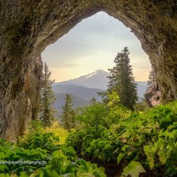
Photo Spots near Mcdowell Creek Falls
Picnic Areas near Mcdowell Creek Falls
Places To Take Pictures near Mcdowell Creek Falls
Playgrounds near Mcdowell Creek Falls
Public Running Track near Mcdowell Creek Falls
Public Shower near Mcdowell Creek Falls
Rock Quarry near Mcdowell Creek Falls
Running Trails near Mcdowell Creek Falls
Rv Rental near Mcdowell Creek Falls
Scenic Drive near Mcdowell Creek Falls
Sunrise View near Mcdowell Creek Falls
Swimming Holes near Mcdowell Creek Falls
Table And Chair Rentals near Mcdowell Creek Falls
Tennis Courts near Mcdowell Creek Falls
Watch Sunset near Mcdowell Creek Falls
Browse Brands
Related Searches in Lebanon, OR
Affordable Jet Ski Rental Options in Lebanon, Oregon
Affordable Kayak Rental Services in Lebanon, Oregon
Best Fishing Locations and Guides in Lebanon, Oregon
Best Fun Things to Do in Lebanon, Oregon
Best Off Leash Dog Parks in Lebanon, Oregon
Best Parks for Parties and Events in Lebanon, Oregon
Best Places for Horseback Riding in Lebanon, Oregon
Best Water Parks for Kids in Lebanon, Oregon
Check Out Great Playgrounds in Lebanon, Oregon
Check Out Off Road Trails in Lebanon, Oregon
Discover Baseball Fields Around Lebanon, Oregon
Discover Dog Friendly Trails to Explore in Lebanon, Oregon
Discover Free Parking Options in Lebanon, Oregon
Discover Fun Activities to Do in Lebanon, Oregon
Discover Fun Toddler Parks in Lebanon, Oregon for Your Little One
Discover Popular Photo Spots in Lebanon, Oregon
Discover Scenic Waterfall Spots in Lebanon, Oregon
Discover Soccer Fields in Lebanon, Oregon Near You
Discover a Hiking Trail in Lebanon, Oregon
Discover the Best Beaches in Lebanon, Oregon
Discover the Best Night Hike Trails in Lebanon, Oregon
Enjoy Camping Adventures Around Lebanon, Oregon
Enjoy Exciting Mountain Biking Adventures in Lebanon, Oregon
Enjoy Kayaking Adventures in Lebanon, Oregon
Enjoy Tent Camping Spots Around Lebanon, Oregon
Enjoy a Beautiful Waterfall Hike in Lebanon, Oregon
Enjoy the Best Walking Trails in Lebanon, Oregon
Exciting Cliff Jumping Spots in Lebanon, Oregon
Explore Beautiful Botanical Gardens in Lebanon, Oregon
Explore Beautiful Parks and Green Spaces in Lebanon, Oregon
Explore Easy Hikes Perfect for All in Lebanon, Oregon
Explore Family-Friendly Zoos and Wildlife in Lebanon, Oregon
Explore Fun Activities to Do in Lebanon, Oregon
Explore Nature Spots Around Lebanon, Oregon
Explore Popular Campgrounds Near Lebanon, Oregon
Explore Popular Picnic Areas Around Lebanon, Oregon
Explore Popular RV Parks Around Lebanon, Oregon
Explore Popular Recreation Centers Around Lebanon, Oregon
Explore Popular Scenic Overlook Points in Lebanon, Oregon
Explore Scenic Lakes to Visit in Lebanon, Oregon
Explore Top Dog Parks in Lebanon, Oregon Near You
Explore Top Gyms in Lebanon, Oregon Now
Explore Top Water Parks in Lebanon, Oregon Today
Explore the Best Boating Spots in Lebanon, Oregon
Explore the Best Swimming Holes Around Lebanon, Oregon
Find Beautiful Views in Lebanon, Oregon
Find Fun Kids Activities Outdoor in Lebanon, Oregon
Find Popular Ziplining Spots Around Lebanon, Oregon
Find Top Dog Friendly Parks to Visit in Lebanon, Oregon
Find Top Skate Parks in Lebanon, Oregon for All Skill Levels
Browse Articles
People who viewed Mcdowell Creek Falls also viewed
Leaburg Hatchery
3 reviews
Green Peter Lake
1 review
Willamettan's
13 reviews
christopher columbus park
1 review
Century Farm Equestrian Center
3 reviews
Cascadia State Park
4 reviews
McKenzie River Fishing Guides and Rafting Tours
1 review
Tokatee Golf Club
21 reviews
The Archery Hut
3 reviews
Ata Black Belt Academy
1 review