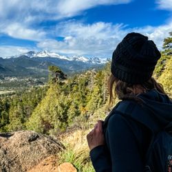
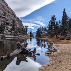
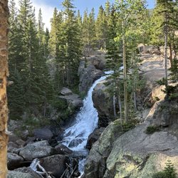
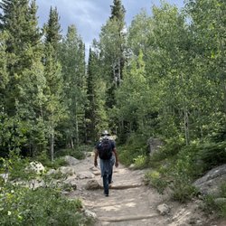
Lumpy Ridge Trailhead Photos


More like Lumpy Ridge Trailhead
Recommended Reviews - Lumpy Ridge Trailhead
Start your review...

7 years ago


5 years ago
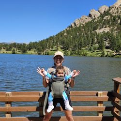
This was a beautiful hike we did with our twin boys who are 12. It was a bit longer than we thought, we are fairly fit but from Texas so we were easily winded and took breaks. It is a pretty easy hike BUT there is a lot of steep parts, lots of steep steps. There were a few icy patches as it was winter when we were there. The views are amazing on this trail. The lake is small but still pretty at the end! Going down is always easier haha. We enjoyed this one since Hollowell Park in RMNP was closed. read more


5 years ago
Super cool spot to hike, and our kids loved climbing the huge boulders along the way. Very pretty views and fun for all! read more

4 years ago
8 years ago
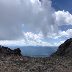
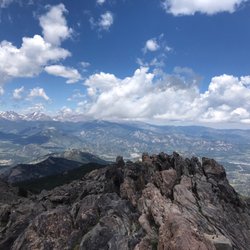
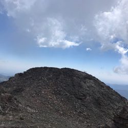
Lumpy Ridge trails are very scenic. Parking is usually full. But can park on the street and walk up to the trailhead. Twin owls and gem lake are all good hikes. Gem lake trail is mostly uphill. But it's a short 1.7 miles hike. To get a clear shot of the gem lake is always challenging. There are always people walking on the boulders or rock climbing. Leave your pets at home. None of the trails here allow dogs. read more


11 years ago
13 years ago
More info about Lumpy Ridge Trailhead
Lumpy Ridge Rd
Estes Park, CO 80517
Directions
Hours
Outdoor Amenities
Ask the Community - Lumpy Ridge Trailhead


Lumpy Ridge Trailhead - hiking - Updated June 2026
Best of Estes Park
People found Lumpy Ridge Trailhead by searching for…
Rock Climbing in Estes Park, Colorado
Hiking Trails in Estes Park, Colorado
Scenic Views in Estes Park, Colorado
Lookout Points in Estes Park, Colorado
Things to Do at Night in Estes Park, Colorado
Scenic Overlook in Estes Park, Colorado
Photo Spots in Estes Park, Colorado
Easy Hikes in Estes Park, Colorado
Sunset View in Estes Park, Colorado
Picnic Areas in Estes Park, Colorado
Parks for Kids in Estes Park, Colorado
Hiking With Kids in Estes Park, Colorado
Places to Take Pictures in Estes Park, Colorado
View Points in Estes Park, Colorado
Things to Do With Kids in Estes Park, Colorado
Hiking Trails Kid Friendly in Estes Park, Colorado
Dog Friendly Trails in Estes Park, Colorado
Off Leash Dog Hiking Trails in Estes Park, Colorado
Picnic Food in Estes Park, Colorado
Trails in Estes Park, Colorado
Trending Searches in Estes Park, CO
Black Owned Nail Salons near Lumpy Ridge Trailhead
Boat Rental near Lumpy Ridge Trailhead
Cliff Jumping near Lumpy Ridge Trailhead
Day Trips near Lumpy Ridge Trailhead
Dog Friendly Trails near Lumpy Ridge Trailhead
Fireworks near Lumpy Ridge Trailhead
Fishing Spots near Lumpy Ridge Trailhead
Jet Ski Rental near Lumpy Ridge Trailhead
Kayak Rental near Lumpy Ridge Trailhead
Lakes & Ponds near Lumpy Ridge Trailhead
Outdoor Activities near Lumpy Ridge Trailhead
Places To Walk Around near Lumpy Ridge Trailhead
Public Pools near Lumpy Ridge Trailhead
Public Shower near Lumpy Ridge Trailhead
River Swimming near Lumpy Ridge Trailhead
Rock Quarry near Lumpy Ridge Trailhead
Scenic Night View near Lumpy Ridge Trailhead
Scenic Overlook near Lumpy Ridge Trailhead
Secluded Spots near Lumpy Ridge Trailhead
Soccer Store near Lumpy Ridge Trailhead
Splash Pad near Lumpy Ridge Trailhead
Strawberry Picking near Lumpy Ridge Trailhead
Sunrise View near Lumpy Ridge Trailhead
Swimming Holes near Lumpy Ridge Trailhead
Swimming Lakes near Lumpy Ridge Trailhead
Watch Sunset near Lumpy Ridge Trailhead
Browse Articles
Browse Nearby
BEST of Estes Park, Colorado Restaurants near Lumpy Ridge Trailhead
BEST of Estes Park, Colorado Coffee near Lumpy Ridge Trailhead
BEST of Estes Park, Colorado Things to Do near Lumpy Ridge Trailhead
BEST of Estes Park, Colorado Breakfast near Lumpy Ridge Trailhead
BEST of Estes Park, Colorado Horseback Riding near Lumpy Ridge Trailhead
Browse Brands
Related Searches in Estes Park, CO
Affordable Kayak Rental Services in Estes Park, Colorado
Best Fishing Locations and Guides in Estes Park, Colorado
Best Places for Horseback Riding in Estes Park, Colorado
Best Sledding Spots and Fun in Estes Park, Colorado
Check Out Off Road Trails in Estes Park, Colorado
Discover Dog Friendly Trails to Explore in Estes Park, Colorado
Discover Kid Friendly Hiking Trails in Estes Park, Colorado
Discover Scenic Waterfall Spots in Estes Park, Colorado
Discover the Best Night Hike Trails in Estes Park, Colorado
Enjoy Camping Adventures Around Estes Park, Colorado
Enjoy Exciting Mountain Biking Adventures in Estes Park, Colorado
Enjoy Kayaking Adventures in Estes Park, Colorado
Enjoy River Tubing Adventures in Estes Park, Colorado
Enjoy Tent Camping Spots Around Estes Park, Colorado
Enjoy Water Activities and Fun in Estes Park, Colorado
Enjoy a Beautiful Waterfall Hike in Estes Park, Colorado
Enjoy the Best Walking Trails in Estes Park, Colorado
Exciting Cliff Jumping Spots in Estes Park, Colorado
Experience Thrilling White Water Rafting in Estes Park, Colorado
Explore Beautiful Parks and Green Spaces in Estes Park, Colorado
Explore Easy Hikes Perfect for All in Estes Park, Colorado
Explore Fun Activities to Do in Estes Park, Colorado
Explore Popular Campgrounds Near Estes Park, Colorado
Explore Popular Scenic Overlook Points in Estes Park, Colorado
Explore Scenic Lakes to Visit in Estes Park, Colorado
Explore Top Dog Parks in Estes Park, Colorado Near You
Explore the Best Boating Spots in Estes Park, Colorado
Explore the Best Swimming Holes Around Estes Park, Colorado
Explore the Best Trail Options in Estes Park, Colorado
Family Friendly Hiking With Kids in Estes Park, Colorado
Find Beautiful Views in Estes Park, Colorado
Find Cozy Camping Cabins in Estes Park, Colorado
Find Popular Ziplining Spots Around Estes Park, Colorado
Find the Best Playgrounds to Visit in Estes Park, Colorado
Find the Best Scenic View Locations in Estes Park, Colorado
Hiking Trails With Waterfalls in Estes Park, Colorado
Off Leash Dog Hiking Trails in Estes Park, Colorado
Plan a Scenic Drive Route Near Estes Park, Colorado
Popular Outdoor Activities to Try in Estes Park, Colorado
Popular Picnic Spots to Visit in Estes Park, Colorado
Popular Things to Do in Estes Park, Colorado
Safe River Swimming Areas in Estes Park, Colorado
Safe and Fun Parks for Kids in Estes Park, Colorado
Top Climbing Spots and Gyms in Estes Park, Colorado
Top Places for Snorkeling in Estes Park, Colorado
Top Running Trails to Explore in Estes Park, Colorado
Top Swimming Lakes to Enjoy in Estes Park, Colorado
Top Swimming Spots and Pools in Estes Park, Colorado