Cancel

    Open app

    Search

    Lost Mines Trail

    4.8 (5 reviews)
    Open Open 24 hours

    Lost Mines Trail Photos

    Recommended Reviews - Lost Mines Trail

    Your trust is our priority, so businesses can't pay to alter or remove their reviews. Learn more about reviews.
    Yelp app icon
    Browse more easily on the app
    Review Feed Illustration

    Reviews With Photos

    Shradha A.

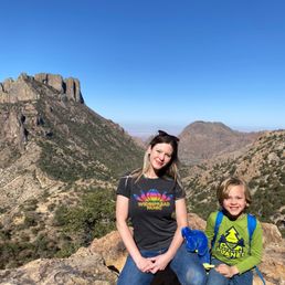
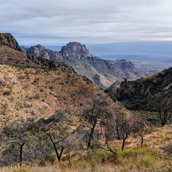
    This is a great option for an afternoon hike because it's mostly shaded and because you're climbing up a hill, it's cooler too. The view payoffs are basically at the 0.5 mile mark and then again at the very top - after you've climbed 2.2 miles. The view doesn't change much during the climb. The path is defined and relatively easy until the very last 0.1 mile, which gets steep. The 360 degree views from the top are worth the hike up. Beware of bugs and snakes on this trail. And definitely carry water.

    See all

    5 months ago

    Helpful 1
    Thanks 0
    Love this 1
    Oh no 0

    6 months ago

    Helpful 0
    Thanks 0
    Love this 0
    Oh no 0

    8 months ago

    Helpful 0
    Thanks 0
    Love this 0
    Oh no 0

    5 years ago

    Helpful 0
    Thanks 0
    Love this 0
    Oh no 0

    4 years ago

    Helpful 1
    Thanks 0
    Love this 1
    Oh no 0

    Verify this business for free

    Get access to customer & competitor insights.

    Verify this business

    Big Bend National Park - Big Bend Welcoming

    Big Bend National Park

    4.7(155 reviews)
    6.1 mi

    My husband and I made a trip out to Big Bend National Park before the Texas summer heat.....but it…read morewas unfortunately unseasonably hot this year. The dessert was beautiful and the park as a whole was very well taken care of! Old Mine Trail: Since we went around "Spring Break", the parking lot was very busy and spaces were limited. I would recommend downloading the "All Trails" app to gauge how busy the trails are. By 7:30, all the spots in the small parking lot were already taken. The trail itself was very well managed. Although the parking lot was busy, the trail was not bad! We were pretty spaced out between hikers! Take lots of water and snacks! The views up top are spectacular. Star Gazing: We were at Sotol Vista (for panoramic stars). The stars were especially beautiful inside the park because there was no light pollution (aside from the headlights from passing cars down below us).

    I once hiked to the bottom of the Grand Canyon and spent a few nights camping down there. While…read moredown there, an elderly man easily every bit of 70 years old asked me if it was my 1st time down at the bottom. I told him that it was and asked him if it was his 1st time. He chuckled and said, "No this is my Sanctuary". After my 3rd visit to Big Bend in 12 years, I think Big Bend may be my sanctuary. Big Bend is in the middle of nowhere. You do not just stumble upon Big Bend; it is a planned destination. You won't find a Gatlinburg like town next to it or an exit sign off the interstate saying 8 miles from here. It's miles from anything. The type of place you don't pass a gas station, and you carry a case of water in the vehicle. We have hiked various trails before and canoed Santa Elena Canyon, but I will focus on the trails we hiked this visit. Note: I have only done day hiking here, so no Insite in this review about backpacking although I would love to at some point. We started off at the visitor's center at Panther Junction as everyone should do in my opinion. Rangers can give you up to the minute updates like telling us the Hot Springs road was still closed because of a flood this past July (2025). She said we could still hike it but it would add an additional 4 miles (2 each way) to our trip. Good Insite. Our 1st hike was a short one in Boquillas Canyon. It was a short 1.4-mile round trip up a small cliff and back down to the Rio Grande river. It was an extremely easy hike that anyone who can walk can do. we then did a forementioned Hot Springs hike. This is a very cool spot with old, abandoned buildings from a time when the area was a resort. There is still a hot spring alongside the river that had people soaking as we walked past. The only downfall of the area was it still hadn't been repaired since the flood, so picnic tables were under sand, and I don't want to tell you what the bathroom looked like. The next day we did the Window Trail and it's a 5.6 miles hike right in the middle of the Chisos Basin. This one was I guess I would call moderate, but I am also an overweight old fart. It's really not bad except if it's hot out because you will be in the direct sun and the small number of switchbacks on your return trip. Other than that, the views are gorgeous. Just don't slide off the rocks at the "window", it's a long way down. The last hike we did was the Grapevine Hill's Trail aka The Balanced Rock. This one is a little more challenging to get to as you have to drive miles down a dirt road that is a little rocky. You don't need a 4-wheel drive, just don't be a speed demon. The hike itself is short, 2.2 miles each way and 95 percent of it is easy. The last little bit is a rock scramble up to see the balanced rock. It is worth it. Amazing views. We had the whole area to ourselves for most of the hike but saw lots of people on the way back so go early. Big Bend is amazing but requires some planning. Don't wing it. Bring lots of water and be smart. Cell service is limited but a lot better than 13 years ago.

    Photos
    Big Bend National Park
    Big Bend National Park - Ernst Tinaja | Instagram: @telephonesmoothie

    Ernst Tinaja | Instagram: @telephonesmoothie

    Big Bend National Park - Octillo blossom

    See all

    Octillo blossom

    Emory Peak - Instagram: @telephonesmoothie

    Emory Peak

    4.9(7 reviews)
    2.8 mi

    The hike to Emory peak is iconic and stunning. You get an amazing view of the window along the…read moretrail, and from the top you can see all the way out to the south rim - it's like you really can see forever. The hike is fairly moderate up until you get to the scramble at the very end, which really does require using your whole body - arms and legs. The climb up really isn't all that bad, but coming down was a little bit tricky, even if just because it's easy to forget the path down and there's only one or two feasible options for a normal sized human. That said - I would recommend making the climb to the very top. It's a narrow area, just a few boulders wide - I'd guess that 15 people or fewer can actually fit up there at one time, and that would be standing close to one another. Overall: if you're going to do one long hike in big bend, I would say this should be it. You can do the whole thing round trip within 4ish hours if you walk fast, or take your time and spend longer. But seriously, you cannot beat the views.

    Good hike. A bit strenuous, but worth it…read more But, if I had to choose between the South Rim, and Emory Peak, I would go for the South Rim. It's longer, not quite as strenuous, and more scenically diverse. Seeing the Rio Grand, from the South Rim, was amazing, but this is the Emory Peak page. If the South Rim had it's own Yelp page, I would go 5 stars! Once you get to the top, you are rewarded with a pretty good view, and cell phone coverage. At least we had it on two different networks. So get that selfies stick out, and watch your step. If you are aggressive, fast, and start early, you could probably do Emory and South Rim in the same day. Heading to the South Rim takes you to the path for Emory Peak, but it will add several hours. We did not start terribly early, so we just did a quick out and back, from the Chisos Basin Campground ( https://www.yelp.com/biz/chisos-basin-campground-big-bend-national-park ), which is where we were camping. Bottom line: If your pressed for time, I would skip it. Since we did South Rim, I would rather have seen more of the park, but hiking to the tallest spot in the park was pretty cool! PS. Review is a bit late. We were in early March, 2018.

    Photos
    Emory Peak - Instagram: @telephonesmoothie

    Instagram: @telephonesmoothie

    Emory Peak - Instagram: @telephonesmoothie

    Instagram: @telephonesmoothie

    Emory Peak - Instagram: @telephonesmoothie

    See all

    Instagram: @telephonesmoothie

    Camp Peña Colorado Post Park

    Camp Peña Colorado Post Park

    5.0(2 reviews)
    60.7 mi

    Nice little park south of Marathon. Looks like 1 road in and out. Good for a jog or a bike ride…read more Nice well maintained park. Little pond with ducks. Also looks like there was a pool at some point. Plenty of space for picnics or a little BBQ.

    This hidden gem of a historic public park lies just 5 miles south of tiny Marathon, Texas…read more(population 430). Camp Peña Colorado (today simply known as "Post Park") was the site of a U.S. military encampment around the spring-fed Peña "Colorada" Creek in the late 1800s and now serves as a perfect little picturesque picnic stop on your way out of Big Bend if you're headed back to Austin. If you're lodging in Marathon or otherwise have the time, the nearly deserted scenic road (southbound Avenue D, aka Post Road, the only one to cross the railroad tracks) out to the park is ideal for running, walking, and biking; bicycles can be rented from the Gage Hotel. Located in the middle of the Combs Ranch and generously donated to the county by the family in 1935, the land was converted from the ruins of the old cavalry post to a public park by the Works Progress Administration (WPA). Brewster County now maintains the place, which is surrounded by the Los Caballos Novaculite Mountains. If you're from around these parts, you have likely attended many a public event at Post Park, such as the long-running annual 4th of July Dance, the summer Chili Cook-Off, and the West Fest Cabrito Cook-Off in September. Check the Marathon, Texas tourism page https://www.marathontexas.com/events for details on upcoming events. The park features several educational historic markers and interpretive nature plaques, a few picnic tables & grills, some covered tables, a couple of cinder-block restrooms, a large concrete slab/dance floor, tons of cottonwood shade trees, and a dammed up portion of the creek that is often home to several species of birds and any other critters seeking a free drink. Wildlife such as deer, javelinas, turkey, jackrabbits, quail, and the occasional fox can be seen in the early morning or around sunset. Fishing is allowed. A weathered old wooden sign suggests that camping *could* be an option with a permit, but it's not clear how one would obtain such a permit. You might try calling Brewster County offices to check on that. More info about the park site's history: http://texasmountaintrail.com/plan-your-adventure/historic-sites-and-cities/sites/post-park

    Photos
    Camp Peña Colorado Post Park
    Camp Peña Colorado Post Park
    Camp Peña Colorado Post Park

    See all

    Big Bend Ranch State Park - Hoodoos Trail | Instagram: @telephonesmoothie

    Big Bend Ranch State Park

    4.6(17 reviews)
    65.4 mi

    Big Bend Ranch State Park tends to get overlooked when compared to its big brother Big Bend…read moreNational Park. I myself was guilty of this (and still am to some extent) on my 1st 2 visits to the region. On this 3rd visit, I made it a point to spend a day in the State Park. However, I only explored the river road section from Lajitas to Presidio. I didn't go deeper into the more mountainy region of the park. Here are some of the points I explored. Barton Warnock Visitor's Center- This is where you pay your fee to enter the park, if you aren't stopping to see things then you don't have to pay. It's only like 5.00 per person so don't be a cheapskate. There is a gift shop to get your refrigerator magnet or t-shirt plus a little garden area and small museum about the region. Contraband Movie set- This is about 45 minutes down the scenic river road from Barton Warnock VC. Beware of free-range cattle! It's just a little place to stretch your legs and check out a few buildings used for filming a few B-movies. Plus, there is a few picnic tables if you want to eat by the river. Closed Canyon Trail- 15-20 minutes from Contraband Movie Set. This was the highlight of the day for me. It's only like a 2-mile round trip hike over mostly flat ground through a gorgeous canyon. The canyon is much much cooler (temperature not hipness) than outside the canyon. There is a little (really little) rock scramble to get over before there is a sign that just says, "The end". Hoodoos Trail- This is only about 5-10 mins from Closed Canyon, so we did it on the way back from Presidio. The Hoodoos is said to be a 1.1-mile roundtrip trail but it's all open so there is not a real defined trail that I could see. So you can just walk around the cool looking rock formations and Rio Grande river and take in the nature. There is also a drive-up overlook if you don't want to walk Fort Leaton State Historic Site- 30 mins from Hoodoos. Cool historic fort that wasn't for military use. It was just a family who wanted a spot along the route to El Paso to sell goods and protect his family. Cool place to walk around and take pictures and learn about the region in a different time. Highly recommend the ride from Lajitas to Presidio. Plenty of points of interest along the route and places to grab a bite once in Presidio. Next time I will make may way more into the interior of the park.

    Big Bend Ranch State Park is rugged, remote, and absolutely stunning. With dramatic canyons, vast…read moredesert landscapes, and abundant wildlife, it offers a true backcountry adventure. Less crowded than the national park, it's perfect for hikers, photographers, and solitude seekers. Be prepared this is wild Texas at its finest.

    Photos
    Big Bend Ranch State Park - Hoodoos Trail | Instagram: @telephonesmoothie

    Hoodoos Trail | Instagram: @telephonesmoothie

    Big Bend Ranch State Park
    Big Bend Ranch State Park - Closed Canyon Trail | Instagram: @telephonesmoothie

    See all

    Closed Canyon Trail | Instagram: @telephonesmoothie

    Gage Gardens

    Gage Gardens

    4.9(18 reviews)
    64.3 mi

    What a beautiful hidden gem! The moment you step through the gates it feels like you've entered a…read morewhole new world. My wife and I spent about 45 minutes just wandering, chatting, and taking it all in, we still didn't make it through all 27 acres. The garden is meticulously maintained, with an incredible variety of native Texas plants thoughtfully arranged to highlight the natural beauty of the region. Everywhere you turn, there's something to appreciate from colorful blooms to shaded pathways that invite you to slow down. The fountains and water features are absolutely stunning, adding a sense of calm and tranquility to the walk. The sound of the water pairs perfectly with the natural surroundings, making it a peaceful escape. We noticed lights strung throughout the garden, which makes me think an evening stroll here would be absolutely magical perfect for a date night. If you find yourself in Marathon, don't miss the chance to step inside this garden oasis. It's a place where time slows down and nature truly takes center stage.

    I had a little time to kill while traveling from Big Bend National Park and happened to see this…read moreplace on Google maps. Decided to stop by, and very glad I did. This is a desert oasis that is exceptionally well maintained and cared for. Beautiful dark green grass, big shade trees, and wandering walkways invite you in to relax by a fountain and just enjoy nature. Lots of plants and birds. Dogs are welcome. There is even a little putting green if you have clubs with you and feel so inclined. I stopped in late morning on a Monday and there was only 3 other people I saw while there. Definitely worth a visit!

    Photos
    Gage Gardens
    Gage Gardens
    Gage Gardens

    See all

    Lost Mines Trail - hiking - Updated May 2026

    Loading...
    Loading...
    Loading...