
Big Bend Ranch State Park Photos


More like Big Bend Ranch State Park
Recommended Reviews - Big Bend Ranch State Park
Start your review...

Reviews With Photos

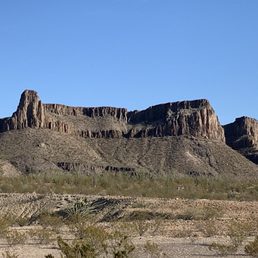
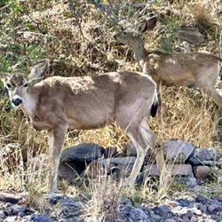
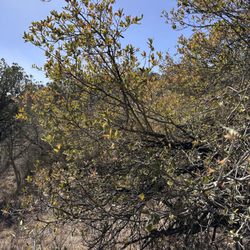
Big Bend Ranch State Park is often overlooked as people over visit it's National Park neighbor to the east. However, when it comes to epic terrain, beautiful lands, awesome wildlife & flora - Big Bend Ranch State Park is just as good. In fact, in my book it is better because it is less visited, more remote, and you often have tens of thousands of acres all to yourself. The facilities are clean & well maintained. Plenty of places to camp, get wet, hike, take pics, etc. This has GOT to be on your bucket list of State Parks to visit. Make sure you get there, get a map, and have a FULL tank of gas.


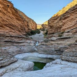
Big Bend State Park is such a vast state park. The roads are not paved, you've been warned. I like the space, hardly saw many people over the long weekend. There are so great trails and spectacular views!! The state park is about 2 hours from the national park. It does take a good amount of time to get from the entrance to the trails. Bring an extra tire, check your tires before you take the trek. The park has 238 miles of trails. Stayed the first night at the overnight spot because it was too far of a drive into the park at nighttime. The second day we went to our spot at South Leyva Campground which is close to headquarters as well as the showers. There are eco toilets at the overnight spot as well as South Leyva Campground. This is not like a porta potty but nice clean toilets. There was no smell!! The wind out at Big Ben was crazy!! Closed Canyon Trail, Cinco Tinajas Loop, Soitario Viewpoint are great hikes. Go to a high spot for sunset!! Big Big State is beautiful!

3 years ago
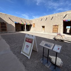
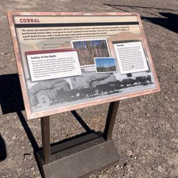
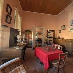
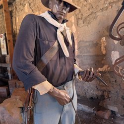
Big Bend Ranch State Park tends to get overlooked when compared to its big brother Big Bend National Park. I myself was guilty of this (and still am to some extent) on my 1st 2 visits to the region. On this 3rd visit, I made it a point to spend a day in the State Park. However, I only explored the river road section from Lajitas to Presidio. I didn't go deeper into the more mountainy region of the park. Here are some of the points I explored. Barton Warnock Visitor's Center- This is where you pay your fee to enter the park, if you aren't stopping to see things then you don't have to pay. It's only like 5.00 per person so don't be a cheapskate. There is a gift shop to get your refrigerator magnet or t-shirt plus a little garden area and small museum about the region. Contraband Movie set- This is about 45 minutes down the scenic river road from Barton Warnock VC. Beware of free-range cattle! It's just a little place to stretch your legs and check out a few buildings used for filming a few B-movies. Plus, there is a few picnic tables if you want to eat by the river. Closed Canyon Trail- 15-20 minutes from Contraband Movie Set. This was the highlight of the day for me. It's only like a 2-mile round trip hike over mostly flat ground through a gorgeous canyon. The canyon is much much cooler (temperature not hipness) than outside the canyon. There is a little (really little) rock scramble to get over before there is a sign that just says, "The end". Hoodoos Trail- This is only about 5-10 mins from Closed Canyon, so we did it on the way back from Presidio. The Hoodoos is said to be a 1.1-mile roundtrip trail but it's all open so there is not a real defined trail that I could see. So you can just walk around the cool looking rock formations and Rio Grande river and take in the nature. There is also a drive-up overlook if you don't want to walk Fort Leaton State Historic Site- 30 mins from Hoodoos. Cool historic fort that wasn't for military use. It was just a family who wanted a spot along the route to El Paso to sell goods and protect his family. Cool place to walk around and take pictures and learn about the region in a different time. Highly recommend the ride from Lajitas to Presidio. Plenty of points of interest along the route and places to grab a bite once in Presidio. Next time I will make may way more into the interior of the park. read more


Big Bend Ranch State Park is rugged, remote, and absolutely stunning. With dramatic canyons, vast desert landscapes, and abundant wildlife, it offers a true backcountry adventure. Less crowded than the national park, it's perfect for hikers, photographers, and solitude seekers. Be prepared this is wild Texas at its finest. read more


2 years ago
Big Bend Ranch State Park is often overlooked as people over visit it's National Park neighbor to the east. However, when it comes to epic terrain, beautiful lands, awesome wildlife & flora - Big Bend Ranch State Park is just as good. In fact, in my book it is better because it is less visited, more remote, and you often have tens of thousands of acres all to yourself. The facilities are clean & well maintained. Plenty of places to camp, get wet, hike, take pics, etc. This has GOT to be on your bucket list of State Parks to visit. Make sure you get there, get a map, and have a FULL tank of gas. read more

3 years ago
To visit the larger State park in texas was a big accomplishment for us The views are breathtaking. I love roller coasters, but my tummy was a little uneasy going through the steep hills and winding roads. Felt a bit dizzy, and yet enjoyed every moment. A must see for sure! read more


Big Bend State Park is such a vast state park. The roads are not paved, you've been warned. I like the space, hardly saw many people over the long weekend. There are so great trails and spectacular views!! The state park is about 2 hours from the national park. It does take a good amount of time to get from the entrance to the trails. Bring an extra tire, check your tires before you take the trek. The park has 238 miles of trails. Stayed the first night at the overnight spot because it was too far of a drive into the park at nighttime. The second day we went to our spot at South Leyva Campground which is close to headquarters as well as the showers. There are eco toilets at the overnight spot as well as South Leyva Campground. This is not like a porta potty but nice clean toilets. There was no smell!! The wind out at Big Ben was crazy!! Closed Canyon Trail, Cinco Tinajas Loop, Soitario Viewpoint are great hikes. Go to a high spot for sunset!! Big Big State is beautiful! read more


Absolutely fantastic state park! Possibly my favorite in Texas. Many trails, with several being off the main road and easily accessible. Stunning views on the drive from Lajitas to Presidio! And who knew we have hoodoos in Texas?!? Do not miss this park if you are visiting the area. read more


6 years ago
Well worth the drive down 170. Beautiful scenery and lots of places to pull off and get photos or just soak it in. There were several hiking and camp sites too. Photos just don't do it justice. read more


6 years ago
6 years ago
13 years ago
18 years ago
15 years ago
More info about Big Bend Ranch State Park
Ask the Community - Big Bend Ranch State Park
Review Highlights - Big Bend Ranch State Park


Big Bend Ranch State Park - rafting - Updated July 2026
Best of Presidio
People found Big Bend Ranch State Park by searching for…
Browse Articles
Browse Nearby
BEST of Presidio, Texas Things to Do near Big Bend Ranch State Park
BEST of Presidio, Texas Restaurants near Big Bend Ranch State Park
BEST of Presidio, Texas Coffee near Big Bend Ranch State Park
BEST of Presidio, Texas Horseback Riding near Big Bend Ranch State Park
BEST of Presidio, Texas Hotels near Big Bend Ranch State Park
BEST of Presidio, Texas Hiking near Big Bend Ranch State Park
BEST of Presidio, Texas Breakfast near Big Bend Ranch State Park
BEST of Presidio, Texas Lodging near Big Bend Ranch State Park
BEST of Presidio, Texas Transportation near Big Bend Ranch State Park
Browse Brands
Related Searches in Presidio, TX
Best Nature Trails for Hiking in Presidio, Texas
Best Places for Horseback Riding in Presidio, Texas
Best Places for Stunning Views in Presidio, Texas
Best Spots for Star Gazing in Presidio, Texas
Best Waterfalls and Swimming Holes in Presidio, Texas
Check Out Great Playgrounds in Presidio, Texas
Check Out Off Road Trails in Presidio, Texas
Discover Popular Bike Trails in Presidio, Texas
Discover Popular Photo Spots in Presidio, Texas
Discover Top Nature Parks to Visit in Presidio, Texas
Discover the Best Kayak Tour Options in Presidio, Texas
Discover the Best Night Hike Trails in Presidio, Texas
Enjoy Camping Adventures Around Presidio, Texas
Enjoy Hiking Adventures in Presidio, Texas
Enjoy Kayaking Adventures in Presidio, Texas
Enjoy Tent Camping Spots Around Presidio, Texas
Enjoy Water Activities and Fun in Presidio, Texas
Enjoy the Best Night View Spots in Presidio, Texas
Enjoy the Best Picnic Spots and Ideas in Presidio, Texas
Enjoy the Best Walking Trails in Presidio, Texas
Experience Stunning Sunset Views in Presidio, Texas
Experience Thrilling Rafting Adventures in Presidio, Texas
Explore Beautiful Parks and Green Spaces in Presidio, Texas
Explore Landmarks & Historical Buildings in Presidio, Texas
Explore Nature Spots Around Presidio, Texas
Explore Picnic Parks Near Presidio, Texas
Explore Popular Campgrounds Near Presidio, Texas
Explore Popular Picnic Areas Around Presidio, Texas
Explore Popular RV Parks Around Presidio, Texas
Explore Popular Scenic Overlook Points in Presidio, Texas
Explore Popular Scenic Views Near Presidio, Texas
Explore Popular State Park Destinations in Presidio, Texas
Explore Popular View Points Around Presidio, Texas
Explore Top Camping and Campsites in Presidio, Texas
Explore the Scenic River in Presidio, Texas
Find Beautiful Views in Presidio, Texas
Find Cozy Camping Cabins in Presidio, Texas
Find Picnic Tables for Outdoor Fun in Presidio, Texas
Find Top-Rated Waterfalls in Presidio, Texas Now
Find the Best Parks for Picnics in Presidio, Texas
Locate a Public Shower Facility in Presidio, Texas
Must-See Tourist Attractions Around Presidio, Texas
Perfect Spots to Watch Sunset in Presidio, Texas
Plan a Scenic Drive Route Near Presidio, Texas
Popular Outdoor Activities to Try in Presidio, Texas
Popular Picnic Spots to Visit in Presidio, Texas
Popular Places to Take Pictures in Presidio, Texas
Popular Places to Walk Around in Presidio, Texas
