Cancel

    Open app

    Search

    Long Man Photos

    Recommended Reviews - Long Man

    Your trust is our priority, so businesses can't pay to alter or remove their reviews. Learn more about reviews.
    Yelp app icon
    Browse more easily on the app
    Review Feed Illustration
    Photo of Jake D.
    3
    61
    13

    9 years ago

    Helpful 0
    Thanks 0
    Love this 0
    Oh no 0

    Long Man Reviews in Other Languages

    Verify this business for free

    Get access to customer & competitor insights.

    Verify this business

    Combe Hill Neolithic Camp

    Combe Hill Neolithic Camp

    5.0(1 review)
    2.8 km

    This is a 5,400 year-old Neolithic causewayed camp or enclosure, situated on Combe Hill between the…read moreEastbourne suburb of Willingdon and the village of Jevington. Although there isn't a great deal to see unless you're an aficionado, it's a lovely place for a walk, with great views, and it is older than Stonehenge! History and what to see The camp consists of two (possibly three) sets of concentric ditches and ring is the most complete of the three, measuring 90 by 70 metres and enclosing an area of 0.53 hectares, and rising to 1.2m. That may not sound much, but archaeological finds of flints, animal bones, an unusual small carved chalk block and Ebbsfleet Ware pottery have dated the site to around 3,400BC - earlier than the first phase of Stonehenge. It's not surprising that erosion over the millennia have reduced its physical impact. Evidence also suggests that, when built, it would have been constructed in newly cleared forest. Finds from the ditches indicate the site was used up to the fourth century AD, possibly for votive offerings, but its use is unlikely to have continuous. The material includes Bronze Age Beaker Ware pottery, bronze rings and Roman coins. It's not exactly known what such enclosures were used for, but it is unlikely to have been continuously inhabited. It has been speculated that they were religious or social meeting places, cattle enclosures or trade centres, and were rare clearings in otherwise dense forest. There are three bronze Age barrows adjacent, one to the west and two to the east, and date from around 2,000BC. The western 'Bowl' barrow rises to nearly 2m, and is 20m in diameter. In 1908 four Bronze Age axe heads were found within the mound. The other two mounds to the east are slightly smaller, but all three may have been damaged by early and unrecorded amateur antiquarian investigations which have reduced their height. Practicalities The site lies a mile from Willingdon and 1.5 miles from Jevington on the 1066 Country Path, Ordnance Survey reference TQ 5702. It's 600ft up, so allow a good half hour to reach it from either starting point, and take a map and good shoes - the paths can be very steep, and the grass can be slippery in wet weather.

    Photos
    Combe Hill Neolithic Camp - Approaching the hill summit from Jevington on the 1066 Country Walk path, with the western Bronze Age barrow on the left.

    Approaching the hill summit from Jevington on the 1066 Country Walk path, with the western Bronze Age barrow on the left.

    Combe Hill Neolithic Camp - A section of one of the ditches (centre) and banks (to the left) of the causewayed enclosure. Built c. 3,400BC.

    A section of one of the ditches (centre) and banks (to the left) of the causewayed enclosure. Built c. 3,400BC.

    Combe Hill Neolithic Camp - Standing in one of the concentric ditches, with the bank to the right; the causeway across it is straight ahead. The bank on the

    See all

    Standing in one of the concentric ditches, with the bank to the right; the causeway across it is straight ahead. The bank on the

    The Long Man of Wilmington

    The Long Man of Wilmington

    4.8(4 reviews)
    4.3 km

    The Long Man is one of several chalk figures cut in the landscape of southern England, and along…read morewith the Cerne Abbas giant, one of only two human figures. At over 70m tall, the Long Man is Europe's largest representation of the human form and the second largest in the world. The figure is formed from trenches dug into the ground to reveal the chalk substrate below. History So who is he? His age has long been a mystery and is the topic of fierce dispute. The first recorded image is a drawing made in 1710, which showed him with facial features, a helmet-like head and his feet pointing outwards. It showed the outline as more of an indentation in the grass than a solid white line. Subsequent 18th century drawings depicted the 'staffs' as being a scythe and a rake, although evidence on the ground does not support this - nor the theory that, like the Cerne Abbas giant, he once had genitalia. An archaeological analysis in 2003 of the chalk on the hillside gave a mid-16th century date, although some excavations have produced Roman pottery from the trenches, implying a pre-Roman date. Similar Northern European depictions of helmeted figures with staffs or spears appear from the Iron Ages to the Viking periods and on Roman coins. If he is pre-mediaeval, it is however strange that there is no reference to the figure in the records of the nearby Wilmington Priory. We will probably never know for sure, but there's no doubt that he cuts an imposing figure on the landscape. Whatever his origins, the current image was formed in 1874 when outlined in yellow brick by Rev. W. de St. Croix of the Sussex Archaeological Society, although even then it was realised that the new outline distorted the original image. In 1891 the bricks were replaced with white versions, painted regularly to keep him fresh, but was rather ignominiously painted out using green paint during World War II to prevent him being used as a landmark by enemy planes! In 1969 the outline was remade using concrete blocks into the form we see today. Practicalities There's a car-park just south of the ruined Priory in Wilmington village, from where a public footpath take you right up to the figure. There are excellent views from a wide area of the surrounding countryside.

    I grew up in this village, with its majestic chalk man looking down over us each and every day…read more When we were youngsters we used to be able to take our sleds up on a snowy day and whizz down over the Long Man but over recent years they have taken much better care of him and now have fencing erected to preserve him. The walk is quite steep and if you are not too sure-footed, it would be best to just admire the view from the lower levels as both access points (either to the left or to the right of the Priory carpark exit) are very rough. muddy and pitted by horses hooves. Pagans celebrate around the Long Man on specific pagan/wicca "holidays", such as Imbolc, Beltane, Lammas and Samhain (Hallowe'en) including the equinox celebrations although obviously they are also not allowed on to the figure itself. No-one really knows where he came from 'tho many theories exist. Locals believe he is an older figure, along the lines of the White Horse in the West Country but whatever, he is a powerful image and draws many many tourists to the area each year. He rests in a dip in the Sussex Downs, in many respects sheltered from the worst of the weather from inland and the coastal region (which is only a few miles away). There are plenty of pathways and walks across the Sussex Downs, for example starting off in Polegate and walking across to the River Cuckmere at Exceat, a beautiful walk, which will bypass our Long Man.

    Photos
    The Long Man of Wilmington
    The Long Man of Wilmington
    The Long Man of Wilmington

    See all

    Herstmonceux Castle - Herstmonceux Castle gardens

    Herstmonceux Castle

    5.0(2 reviews)
    8.3 km

    Herstmonceux Castle is an almost fairytale-like castle, situated in rolling countryside in East…read moreSussex, 10 miles from Eastbourne. The castle buildings themselves are now part of a Canadian College and are not open to the public, but the magnificent gardens are open to the public. There's also a tearoom where you can have refreshments afterwards. Begun in 1441, the castle was begun by Sir Roger Fiennes and completed by his son, Lord Dacre. It was the first major building built in brick in southern England since Roman times. After the fortunes of the family declined, the castle was partially dismantled in the late 18th century and stood as a picturesque ruin until the early 20th century when it was restored to its present form. After the Second World War, the estate became home to the Royal Greenwich Observatory, moved from London because of increasing light pollution and excessive ground movement from trains and traffic. (This is now the Observatory Science centre - see separate reviews.) The Observatory closed in the 1980s and in the 1990s became part of Queen's College, Ontario, as Bader College. Access to the grounds is available daily February to November, £8 for adults and £3.50 for 4-17s. Season tickets are available for regular visitors and there are discounts for those living locally. The castle grounds are extensive, and the castle itself sits at one end of a lake with an impressive moat at the front. The gardens include the quadrangle in the middle of the castle, which is followed by a series of walled gardens. These have magnificent herbaceous borders, as well as an Apothecary's garden, Rose Garden, Elizabethan Garden, and walks around the castle moat, and across a wildflower meadow up to a Folly and lake. It's worth a visit of at least a couple of hours. There's a gift shop and cafe - we had a pot of tea for two and really excellent cakes on our visit (a toffee apple muffin and a pumpkin and ginger cake) for under £10. The ticket office entrance is on the east of the estate, accessed through the grounds of the Science Observatory. There is a small car park opposite the main entrance to the front of the castle (parking on gravel / grass). From the village and mediaeval church, access is indirect via public footpaths, but there is no vehicular access this way.

    Boasting a fairly colorful history, including standing as an exterior walls-only edifice for well…read moreover a century, Herstmonceux Castle's name derived from very early 12th century owners of a manor house that existed on the site, Idonea de Herst who married Ingelram de Monceux, a Norman nobleman. At that time, the manor house was called "Herst of the Monceux." There is evidence that in 1066 some other structure existed before the manor in this location. During most of the 20th century it was vacant, Then, in 1992, it became part of Queen's University at Kingston (Ontario, Canada) and was known as Queen's International Study Centre (ISC), with primarily arts or commerce students. The name later changed, in 2009, to Bader International Study Centre, after Alfred Bader, the Queen's alum who first had the idea to turn this castle into a university study center. Gaining entry may not be possible but the exterior is incredible. Well worth the visit.

    Photos
    Herstmonceux Castle - Herstmonceux Castle

    Herstmonceux Castle

    Herstmonceux Castle - Herstmonceux Castle gardens

    Herstmonceux Castle gardens

    Herstmonceux Castle - Herstmonceux Castle

    See all

    Herstmonceux Castle

    Bramber Castle - Bramber castle - dry moat

    Bramber Castle

    3.8(6 reviews)
    39.9 km

    Built to defend an important port on the River Adur, Bramber Castle was constructed as a motte and…read morebailey castle around 1073 by William De Braose, who fought alongside William the Conqueror at the battle of Hastings in 1066. Apart from a period of confiscation during the reign of King John, it remained in the ownership of the De Braose family until themale line died out in 1324. Thereafter, it passed via the Mowbray and Howard families into the estate of the Dukes of Norfolk, who held it until it until 1926. It was given to the National Trust in 1946. Very little survives of the original castle, thanks to a gradual decline over the years, damage during the Civil War in 1642 and looting of the stones as a quarry for building by the locals. The most prominent feature is the tall and unsteady-looking fragment of the Gatehouse tower, still standing to almost its full original height. In the centre of the grounds is the impressive original motte, its earthen mound rising some 30ft (10m). A short distance away is a section of the curtain wall which survives up to 10ft (3m) in places. Around the perimeter are also the remains of the castle's impressive moat. (NB be careful with small children, as there are some sheer drops in places). Although the ruins are rather fragmentary, the grounds are beautifully kept by the National Trust, and make a wonderful place for a picnic, as well as affording excellent views of the surrounding countryside.

    This place is a bit of a let down. There seems to be no effort to make it obvious where/what parts…read moreof the ruins were. They have a lame sign at the entrance but little else. It just seems like an enclosed play field.

    Photos
    Bramber Castle
    Bramber Castle - Bramber Castle - remains of main gatehouse

    Bramber Castle - remains of main gatehouse

    Bramber Castle

    See all

    Church of St Michael and All Angels, Southwick

    Church of St Michael and All Angels, Southwick

    5.0(1 review)
    34.1 km

    Southwick is now firmly part of the suburban sprawl running from Brighton and Shoreham, and is…read moreknown to most people for the power station that dominates the far side of Shoreham Harbour. But there was a community here in Saxon times, and its church is surprisingly ancient. In fact, the walk from the station crosses the Green, an attractive and villagey stretch of tree-lined common which splits Southwick into two halves. There are some handsome cottages surrounded by well appointed semi-detached suburban homes, and a rather less appealing row of post-war shops. St Michael and All Angels was, until the 18th century, dedicated to St Margaret, and sits among a very pretty churchyard, thickly studded with trees. Although there was probably a church here in Saxon times, it first recorded in 1086, and in 1206 the right to appoint the rector was granted to the Templars, and then to the Hospitallers, although much of the early mediaeval period was taken up with disputes over these rights with the monks of Sele Priory. The ownership passed from Sele Priory to Magdelene College at the Dissolution, and patronage thereafter passed to the Crown until the 20th century. Fire in the 19th Century damaged the nave and an unexploded bomb (and the subsequent excavation to remove it) damaged the tower in 1941. 
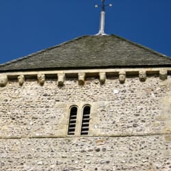
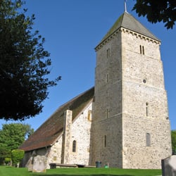
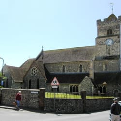
The church itself is built of flint, and is essentially in three parts: the tower, nave and chancel. The tower is by far the most impressive part: its foundations and lower walls are said to be Saxon, although it mostly dates from the late 12th and 13th centuries. 
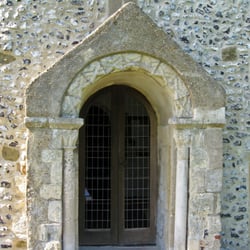
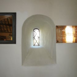
It is an attractive composition, with paired round-headed arches with narrow openings surmounted by paired gothic lancets and, above that, a shingle broach spire. The west door is also attractive, but a modern addition: the tower was carefully taken down and faithfully rebuilt in 1950 after the bomb damage, with vestries built either side. 
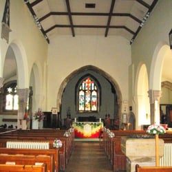
The chancel is mostly 13th century, with two original lancets, framed by a 14th century chancel arch. There are two round headed arches to the south, although the central column probably dates from the Victorian rebuilding. A 14th wooden screen with narrow lancets also survives in the south aisle. The nave burned down in the 1830s and was rebuilt with narrow lean-to aisles in 1834, with round-headed arcades and lancet windows. Pevsner's Buildings of England described the nave as a 'loveless cover for pew-space', which I think is a bit harsh, although there's no doubt it doesn't match the quality of the tower. 
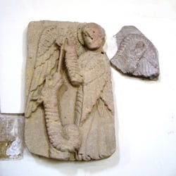
The furnishings other than the south aisle screen - are limited in interest to what appears to be a mediaeval aumbry, some 18th and 19th century tombs and memorials, and a sturdy, square font, probably from the 13th century. The church is today the centre of large and busy parish, and has a vibrant church life, with services daily through the week.

    Photos
    Church of St Michael and All Angels, Southwick
    Church of St Michael and All Angels, Southwick
    Church of St Michael and All Angels, Southwick

    See all

    St Andrew's Church

    St Andrew's Church

    5.0(1 review)
    11.6 km

    Bishopstone seems in a world of its own. Driving up a narrow lane from the busy Newhaven-Seaford…read moremain road, you leave behind a dull modern housing estate, before climbing through woods up into a tranquil blind valley. The lane is the only connection to the outside world. The village itself is a picture postcard: rustic flint cottages and houses have lovely country gardens, all set around the church and village hall. The village is a Conservation Area, and the valley is an Area of Outstanding Natural Beauty. The inhabitants are indeed fortunate. The Church was built between 700 and 800 AD and is perhaps the oldest Saxon Church in Sussex. A grand Saxon porch has a sundial inscribed 'Eadric' and a fine Norman carved doorway. The imposing tower, with its pyramidal cap, is Norman work, and has a complete series of carved corbels. These depict wonderfully stylised heads of people and animals. The nave is basically Saxon, but extended by the Normans with the addition of a north aisle and chancel. Although the aisle has 11th century windows, the arcading and chancel arch are later Early English work of about 1200. The chancel has decorative blind arcading with delicate zig-zag carving and a spacious vault. Other details include a medieval aumbry and a piscina in the Sanctuary, and the remnant of a wall painting on the West wall. Perhaps most interesting of all is a Norman tombstone, which hangs beneath the tower space. It is decorated with a twisted rope design, formed into roundels, containing a carvings of two doves drinking, a lamb and a cross on a pedestal. It is in amazing condition for its 900 years. Perhaps it belonged to the grave of some local saint?

    Photos
    St Andrew's Church
    St Andrew's Church
    St Andrew's Church

    See all

    Church of St Leonard

    Church of St Leonard

    5.0(1 review)
    11.6 km

    Seaford is very quiet as seaside towns go - there's not even an amusement arcade on the seafront…read moreand, on my visit, only a few souls were braving the breeze on the promenade. But this is an ancient town - one of the original Cinque Ports - developed by the Normans after the Conquest to facilitate trade with Normandy. The church was built in 1090, and enlarged in several stages during the mediaeval period. However, it suffered badly from French raids during the Hundred Years' War, and the port declined sharply after the river Ouse changed its course in the late 16th century. It was not until the Victorian period that the railway brought renewed prosperity, and a significant rebuilding in 1861-2 delivered the building we see today - now a Grade I listed building. The church is unusually hard to 'read' architecturally, as a complex series of rebuildings have left fragments from several periods, and some formerly internal features are now outside. But essentially, it has a Norman Nave of two bays, rebuilt in the Early English style some time the early 13th century, with an Early English Gothic clerestory. The west tower is mostly late 15th century but has the remains of Norman arches on the south (exposed) and north (now in the vestry) with round arches with shafts and capitals either side, both with a small Norman clerestory window above and, on the south side, an Early English clerestory window above that: a clear indication that, for much of its life, it was part of the nave. The West doorway is largely a Victorian reconstruction of a Norman original. The tower opens through a 14th century arch into the nave. The north aisle also has the remains of two small Norman windows. The spacious crossing arches and apsed chancel are pure Victorian. The most interesting features are found in the nave: the round piers have attractive capitals with stiff-leaf carving, except - notably - one 'Historiated' capital, carved with scenes from the Bible. This is a great rarity, and though it is much weathered, the crucifixion with a weeping Mary and St John the Divine is most clear, with scant remains of Daniel in the lions' den. (A guide shows older photographs which are rather clearer). Other scenes are now too vague to make out. Other features of interest include an excellent sculpted panel of St Michael and the Dragon, dated around 1130, on the north arcade, and an excellent stained glass window by Kempe (1903) in the south aisle. A corbel on the south arcade features two grotesque faces, one upside down. Under the tower is an ancient tombstone, an anthropomorphic tomb chest and a case containing a 17th century King James bible and a copy of the Book of Common Prayer from 1686. The interior has recently been re-floored in pale parquet and is bright and airy, and clearly has a busy parish life: on my visit, I was welcomed warmly by three cheerful pensioners, eager to show off their church.

    Photos
    Church of St Leonard
    Church of St Leonard
    Church of St Leonard

    See all

    Battle Abbey & Battlefield

    Battle Abbey & Battlefield

    4.5(10 reviews)
    19.8 km

    Came here without much expectations. And were suprised by the size of the grounds, all the…read morebuildings and all the things to discover. We've spent many hours here in the end. A real highlight on this years Road Trip through the UK. Parked right next to on the official carpark. Fixed price of 4£ was a fair deal (free for members). We bought tickets online before and there was next to no wait to enter. The Battle of Hastings, fought on 14 October 1066, is one of the best-known events in England's history, when William of Normandy defeated the army of King Harold of England. William the Conqueror founded Battle Abbey. The abbey thrived as a Benedictine monastery for over 400 years, and after its suppression in 1538 the abbot's lodging was transformed into a grand country house. Exploring the Abbey is a great and fun thing to do. There's so much history to read and to take in here. You can go to the top as well, enjoying the views. Or go explore every corner there is - you might find the old toilet here as well (it's named "garderobe"). After enjoying history at the Abbey we walked on the grounds. Checking out the Ice and Dairy House, the King Harold and High Altar Memorial and the Crypt. And a quick look at the walled garden. Then went onto the Battelfield. If you don't have an audio guide, you still can read all the info plates along the way. Really well done and informative. And the walk around the battlefield is a pretty one. With some wildlife as well. We did have our Bulldog with (and a pet stroller) without problems. Just the first section has some steps, after that it's pretty stroller-friendly. Then in the end we've visited the old Abbey ruins. Again: very impressive architecture. We had a great day here. There's so much to see and to do. Of course there's also a shop, a restaurant, a food truck and toilets. Some games for kids as well. A fantastic visit. And surely not to be missed. A must-do.

    I remember coming back here in 2011 and, well, it wasn't so much closed off, it was just that it…read morewas closed. You see, this has been turned into a private boarding school, so you can't really come trapesing through here at any hour of the day. Actually, it's a site of historical significance, so yeah, they usually fence them off as well. Anyway, it's not bad. There are actually wooden cutouts of soldiers around the fields, which is pretty cool. At first I thought this was the school, and apparently you simply can't walk into the school, but not, it is actually the ruins next to the school. The reason these are ruined is because of King Henry (which the English don't seem to be too impressed with). Anyway, it's pretty cool, and you can actually find a number of underground chambers here that you can explore, though they don't happen to be hugely extensive (or if they are, parts of them are being used by the school). Oh, the ticket includes both the abbey and the battlefield.

    Photos
    Battle Abbey & Battlefield - Abbey Ruins

    Abbey Ruins

    Battle Abbey & Battlefield - Abbey Ruins

    Abbey Ruins

    Battle Abbey & Battlefield - Spiral stairs to interior of Abbey Gatehouse

    See all

    Spiral stairs to interior of Abbey Gatehouse

    Long Man - landmarks - Updated May 2026

    Loading...
    Loading...
    Loading...