
Libby Creek Trail Photos


More like Libby Creek Trail
Recommended Reviews - Libby Creek Trail
Start your review...

4 years ago
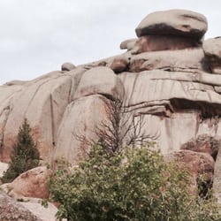
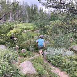
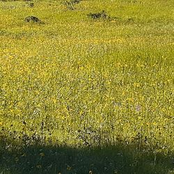
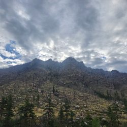
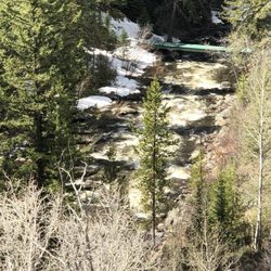
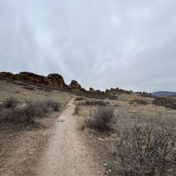
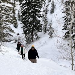
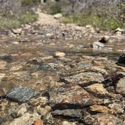
This is a 4.1 mile loop trail rated easy with 669 feet of elevation gain. This trail is out in the middle of nowhere which is nice. You park at the green rock parking lot. It is $5 to park in the lot unless you have a national parks pass. Bring a copy of your pass to leave in your dash if you have a pass otherwise bring $5 cash and a pen to write on the envelope. The trail is mostly shaded and had really lovely views. It follows the stream for a good chunk of the way. There is even a bridge that goes nowhere ;) It does seem like an area that would be likely to have moose though thankfully we did not see any. It is pretty remote, I would bring bear or pepper spray with you. You can add more miles by taking a turn on barber lake trail if you would like. Dogs are welcome as long as they are leashed. read more


More info about Libby Creek Trail


Libby Creek Trail - hiking - Updated July 2026
Best of Laramie
People found Libby Creek Trail by searching for…
Trending Searches in Laramie, WY
Browse Articles
Browse Nearby
BEST of Laramie, Wyoming Restaurants near Libby Creek Trail
BEST of Laramie, Wyoming Coffee near Libby Creek Trail
BEST of Laramie, Wyoming Breakfast near Libby Creek Trail
BEST of Laramie, Wyoming Shopping near Libby Creek Trail
BEST of Laramie, Wyoming Thrift Stores near Libby Creek Trail
Browse Brands
Related Searches in Laramie, WY
Affordable Long Term RV Parking in Laramie, Wyoming
Best Dog Hiking Trails Around Laramie, Wyoming
Best Fishing Locations and Guides in Laramie, Wyoming
Best Fun Things to Do in Laramie, Wyoming
Best Places for Horseback Riding in Laramie, Wyoming
Check Out Off Road Trails in Laramie, Wyoming
Discover Dog Friendly Trails to Explore in Laramie, Wyoming
Discover a Hiking Trail in Laramie, Wyoming
Discover the Best Beaches in Laramie, Wyoming
Discover the Best Night Hike Trails in Laramie, Wyoming
Dog-Friendly Hikes With Dogs in Laramie, Wyoming
Enjoy Camping Adventures Around Laramie, Wyoming
Enjoy Off Leash Dog Hikes in Laramie, Wyoming
Enjoy the Best Walking Trails in Laramie, Wyoming
Experience Stunning Sunset Views in Laramie, Wyoming
Explore Beautiful Parks and Green Spaces in Laramie, Wyoming
Explore Bike Rentals Throughout Laramie, Wyoming
Explore Easy Hikes Perfect for All in Laramie, Wyoming
Explore Fun Activities to Do in Laramie, Wyoming
Explore Popular Campgrounds Near Laramie, Wyoming
Explore Popular RV Parks Around Laramie, Wyoming
Explore Scenic Lakes to Visit in Laramie, Wyoming
Explore Top Dog Parks in Laramie, Wyoming Near You
Explore the Best Swimming Holes Around Laramie, Wyoming
Family Friendly Hiking With Kids in Laramie, Wyoming
Find Exciting Tours to Take in Laramie, Wyoming
Find Fun Things to Do With Kids in Laramie, Wyoming
Find Top Dog Swimming Spots in Laramie, Wyoming
Find the Best Playgrounds to Visit in Laramie, Wyoming
Find the Best Scenic View Locations in Laramie, Wyoming
Find the Best Swimming Pools in Laramie, Wyoming Today
Fun Things for Kids in Laramie, Wyoming
Locate a Public Shower Facility in Laramie, Wyoming
Off Leash Dog Hiking Trails in Laramie, Wyoming
Popular Kids Activities in Laramie, Wyoming
Popular Things to Do in Laramie, Wyoming
Safe and Fun Parks for Kids in Laramie, Wyoming
See Top Fireworks Events in Laramie, Wyoming
Top Hiking Trails to Explore in Laramie, Wyoming
Top Paddleboarding Activities in Laramie, Wyoming
Top Playgrounds for Kids to Enjoy in Laramie, Wyoming
Top RV Campgrounds to Visit in Laramie, Wyoming
Top Swimming Lakes to Enjoy in Laramie, Wyoming
Top Things to Do With Kids in Laramie, Wyoming


