Mount Margaret Photos


More like Mount Margaret
Recommended Reviews - Mount Margaret
Start your review...

11 days ago
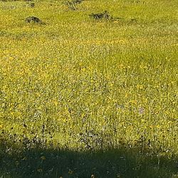
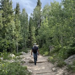
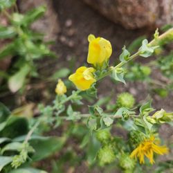
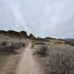
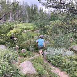
While visiting Red Feather Lakes, I really wanted to stop by at least one hiking area to check it out. The weather was beautiful, and I loved the green expanses near the trailhead. Honestly I didn't make it very far before having to turn back and continue my drive home, but I definitely recommend cruising along this 7.3 mile out-and-back trail that seems relatively flat. Parking is straightforward, and it was not crowded. read more


4 years ago
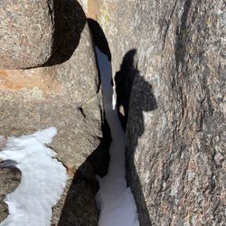
Mount Margaret Trail is a 7.2 mile heavily trafficked out and back trail located near Red Feather Lakes, Colorado that features a lake and is good for all skill levels. The trail offers a number of activity options and is best used from February until November. Dogs and horses are also able to use this trail. This trailhead has a small parking lot. There is a bathroom at the trailhead. There is not however a trash can or dog poop bags. This trail is thankfully one that is not usually over populated. Its 7.2 miles and 540 feet of elevation gain. So its rated easy. Its beautiful in the fall and winter especially! There are lots of aspens in the area and it is a great hike to see fall colors. In the winter the snow contrasts the trees. There are frequently moose sightings in the area. SO just be cautious. Especially if you have your dogs. read more


More info about Mount Margaret


Mount Margaret - hiking - Updated July 2026
Best of Red Feather Lakes
People found Mount Margaret by searching for…
Things to Do in Red Feather Lakes, Colorado
Hiking Trails in Red Feather Lakes, Colorado
Fishing Lake in Red Feather Lakes, Colorado
Fishing Guides in Red Feather Lakes, Colorado
Dog Friendly Trails in Red Feather Lakes, Colorado
Fishing Spots in Red Feather Lakes, Colorado
Bait Shops in Red Feather Lakes, Colorado
Fly Shop in Red Feather Lakes, Colorado
Sunset View in Red Feather Lakes, Colorado
Off Road Trails in Red Feather Lakes, Colorado
Fly Fishing Shop in Red Feather Lakes, Colorado
Trout in Red Feather Lakes, Colorado
Easy Hikes in Red Feather Lakes, Colorado
Fishing Ponds in Red Feather Lakes, Colorado
Public Shower in Red Feather Lakes, Colorado
Caves in Red Feather Lakes, Colorado
Waterfalls in Red Feather Lakes, Colorado
Beautiful Views in Red Feather Lakes, Colorado
Off Leash Dog Hiking Trails in Red Feather Lakes, Colorado
Nature Trails in Red Feather Lakes, Colorado
Trail in Red Feather Lakes, Colorado
Creeks in Red Feather Lakes, Colorado
Trending Searches in Red Feather Lakes, CO
Browse Articles
Browse Brands
Related Searches in Red Feather Lakes, CO
Affordable Fishing Rental Services in Red Feather Lakes, Colorado
Best Boat Launch Spots in Red Feather Lakes, Colorado
Best Fishing Locations and Guides in Red Feather Lakes, Colorado
Best Nature Trails for Hiking in Red Feather Lakes, Colorado
Best Places for Horseback Riding in Red Feather Lakes, Colorado
Best Spots for Star Gazing in Red Feather Lakes, Colorado
Book Top Fishing Trips in Red Feather Lakes, Colorado Today
Check Out Off Road Trails in Red Feather Lakes, Colorado
Discover Dog Friendly Trails to Explore in Red Feather Lakes, Colorado
Discover Popular Bike Trails in Red Feather Lakes, Colorado
Discover Scenic Mountain Bike Trails Near Red Feather Lakes, Colorado
Discover Top Nature Parks to Visit in Red Feather Lakes, Colorado
Discover a Hiking Trail in Red Feather Lakes, Colorado
Discover the Best Fishing Lake in Red Feather Lakes, Colorado
Discover the Best Night Hike Trails in Red Feather Lakes, Colorado
Dog-Friendly Hikes With Dogs in Red Feather Lakes, Colorado
Enjoy Camping Adventures Around Red Feather Lakes, Colorado
Enjoy Hiking Adventures in Red Feather Lakes, Colorado
Enjoy Scenic Night View Experiences in Red Feather Lakes, Colorado
Enjoy Tent Camping Spots Around Red Feather Lakes, Colorado
Enjoy the Best Night View Spots in Red Feather Lakes, Colorado
Enjoy the Best Picnic Spots and Ideas in Red Feather Lakes, Colorado
Enjoy the Best Walking Trails in Red Feather Lakes, Colorado
Experience Stunning Sunset Views in Red Feather Lakes, Colorado
Experienced Fishing Guides Available in Red Feather Lakes, Colorado
Explore Bike Rentals Throughout Red Feather Lakes, Colorado
Explore Easy Hikes Perfect for All in Red Feather Lakes, Colorado
Explore Jet Skis for Sale or Rent in Red Feather Lakes, Colorado
Explore Popular Boat Charters Near Red Feather Lakes, Colorado
Explore Popular Campgrounds Near Red Feather Lakes, Colorado
Explore Popular RV Parks Around Red Feather Lakes, Colorado
Explore Popular View Points Around Red Feather Lakes, Colorado
Explore Scenic Lakes to Visit in Red Feather Lakes, Colorado
Explore Secret Spots Worth Visiting in Red Feather Lakes, Colorado
Explore Top Dog Parks in Red Feather Lakes, Colorado Near You
Explore the Best Bait Shops Around Red Feather Lakes, Colorado
Explore the Best Trail Options in Red Feather Lakes, Colorado
Family Friendly Hiking With Kids in Red Feather Lakes, Colorado
Find Beautiful Views in Red Feather Lakes, Colorado
Find Fun Kids Activities Outdoor in Red Feather Lakes, Colorado
Find Parks and Recreation Activities in Red Feather Lakes, Colorado
Find Top Outdoor Gear Stores in Red Feather Lakes, Colorado
Find the Best Party Boat Experiences in Red Feather Lakes, Colorado
Find the Best Playgrounds to Visit in Red Feather Lakes, Colorado
Find the Best Scenic View Locations in Red Feather Lakes, Colorado
Find the Best Swimming Pools in Red Feather Lakes, Colorado Today
Hiking Trails With Waterfalls in Red Feather Lakes, Colorado
Locate a Public Shower Facility in Red Feather Lakes, Colorado
Off Leash Dog Hiking Trails in Red Feather Lakes, Colorado
Perfect Spots to Watch Sunset in Red Feather Lakes, Colorado