Jump Creek Photos


More like Jump Creek
Recommended Reviews - Jump Creek
Start your review...

Reviews With Photos

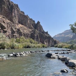
Great spot for a quick and easy hike with a pretty view at the end. We hiked this on our last visit to ID, though hike is a bit of a stretch. It's more of a walk to the falls with very little elevation gain. Pretty doable for most folx, there's a small water crossing and some ducking under low hanging branches but nothing outrageous. I believe you can hike up the hill to the top of the falls and all around the area up there, but we didn't do that this time. The falls are pretty cool and end in a small pool that people were swimming in, refreshing in the afternoon sun. There were some larger boulders to scramble up on the opposite side of the pool and the kiddos had fun doing that. Watch out for poison ivy as you are climbing about, we saw patches of it here and there. Bring something to pack out any trash you may have-there are no trashcans by the falls, and it was disappointing to see how much trash had been left behind.

This is a great EASY hike. If you want to see the waterfall straight on or go for a swim, don't follow the "trail" signs in the dirt. Just keep going down until you see the bathroom and walk through the cold canyon with the sound of the babbling brook. Beware of the poison ivy! Give it a google so you know what it looks like. When you are driving there from Boise it is about an hour if you don't stop in Nampa or Marsing. Nampa has a couple breweries and city center and Marsing has a little old town. It's not all highway like you would think so it takes a bit longer. Anyway, driving there- Cemetery Road is unmarked so it's easy to miss. It's in the middle of farmland. Then when you get to the entrance on Jump Creek Road you will start to see tires on the fences that say no hunting. When you get to the fence that is spray painted with NO TRESPASSING PRIVATE PROPERTY go RIGHT- it is not clearly labeled. Everything is gravelly that you are supposed to be on- if it's dirt then it's private property. There is some easy water crossings and steepness on the trail to the waterfall so i would rate it 3 out of 10 difficulty wise. The higher trail is harder with the devil's ladder. I didn't break a sweat on the waterfall trail. It's pack in and pack out- no trash cans.


Worth the drive from Boise! It was a little tricky to find because the roads are not all clearly marked. Some tips before you go- bring shoes you don't mind swimming in. The floor of the swimming hole is covered with rocks, big and small. Painful to walk on. There water is very cold until you go numb. Shade is limited! Wished I had an umbrella. Bring bug repellent! The hole has bugs that will bite you repeatedly. I watched a bug land on my friend bite, jump somewhere else, bite again.. The repellent seemed to help after applied. I found detailed, accurate directions on world of waterfalls site. My GPS was not useful once I got to the unmarked roads and the parking lot is not visible until you arrive so there are no landmarks to aim for. There are two parking lots. If you are there to swim, I recommend you drive past the first lot, down a narrow road to the lot below.

The permissible hours of the Jump Creek Recreation area are STRICTLY enforced. An Owyhee County Sheriff officer said this is because of criminal and/or dangerous incidents that have occurred here in the past: accidental death, officer impersonation, attempted kidnapping, etc. The current fine for trespassing off-hours is $156 and I've heard the judge rarely dismisses them, regardless of the reason. Several times I've seen an Owyhee County Sheriff truck parked above the parking lot waiting to issue tickets to anyone who lingers beyond the closing time. I posted a pic of the hours sign. Although it is large it can be easy to miss on the drive in if you're not looking for it. That being said, the area is lovely during daylight, although it is popular. A lot of families, groups of teens, and young adults frequent here. Most users leave no trace, but you will likely see some litter. It's a short, easy hike to the falls/swimming hole. Some sections of the trail are sandy and it's easy to slip .. watch your footing. The drive to the area is beautiful, particularly in the Spring. The falls are bigger in the Spring as well, however the trail is likely to be wet and therefore slippery so be careful.

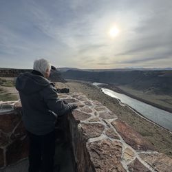
I've only hiked this trail one time before, and it was fantastic. I had no clue that something like this was just an hour outside of Boise! Right when you pull up to the parking lot, you'll see a little trailhead that leads to the waterfall. As you start walking towards the waterfall, the trees will begin to make a sort-of ceiling/canopy (it's majestic!). After a few hundred feet you'll arrive at a stunning waterfall with a little pool of water underneath it! There are various places to hike around here, but (here is my safety-patrol side coming out) be very careful and pay attention to where you are! There are steep ledges next to some of the paths and poison ivy surrounding a lot of the trails. I'm not saying it's super dangerous (I felt safe when I hiked around here), but I am saying you should pay attention to where you are! You can hike pretty high up with not a whole lot other than awareness of your surroundings to keep you safe. **Safety Rant Over** While on the hike you'll find stunning views, gorgeous green trees, streams/creeks of water, and of course, the waterfall! Even if you have no interest in hiking around, it is worth it to come out this way just for the waterfall and to take a dip in the pool of water at the bottom. Note on the 'gorgeous green trees': some of them are poison ivy. PROTIP (that a nice family told me while I was hiking): if poison ivy is blocking your path, step on it at the root and it will cause the plant to bend out of your way without it actually touching you! **Had I not gone on this adventure with a friend, I probably would have gotten lost trying to find my way here, so I wrote down some here to help you make sure you're going the right way: Hop on the I-84 W, take exit 33A to ID 55N/Nampa/Marsing, continue on to US 95N, left on Cemetery Rd, left on S Jump Creek Rd, turn right on Jump Creek Rd, and follow it to the trailhead/parking lot!**

Fun, super short trail (takes about 15 minutes) to get to the Falls where you can take a dip in the beautiful little lake if you're not afraid of the freezing cold! The trail was super picturesque. I loved how because it's in a gorge, it is almost all shaded. We chose it since we have young kids and needed a short trail. I had read that this was super kid friendly and do be warned there are some short steep dusty slopes, and ledgy areas, that made us very nervous with our 5 year old and our 83 year old relative. It's kid friendly in terms of it being short, but there are some nerve racking spots for sure! The best type of shoes for this would be something like hiking sandals that you can get wet since there are areas you need a good grip for hiking, and others where you literally have to hop over stones. The waterfall is breathtaking and we sat there for some time enjoying the view. read more


2 years ago
4 years ago
Not for the handicapped. That would have been good to know ahead of time. The trail was wonderful except one spot. You have to go down a bit of a slippery slope and then up the other side after crossing the creek. The creek has large round stepping stones that are firmly in place to cross over. I have balance issues and had to let go of my dog's leash to balance myself. Other than that part, it was beautiful. It was fairly quiet on the way there, and then a few families showed up. Great for kids. There is a spot where it's narrow against the creek, and you have to be careful not to step in the water. Not too long of a walk/ hike if you aren't used to hiking. There are alternate trails to explore along the way. Cool outcroppings and small caves in the canyon along the walk. read more


Great spot for a quick and easy hike with a pretty view at the end. We hiked this on our last visit to ID, though hike is a bit of a stretch. It's more of a walk to the falls with very little elevation gain. Pretty doable for most folx, there's a small water crossing and some ducking under low hanging branches but nothing outrageous. I believe you can hike up the hill to the top of the falls and all around the area up there, but we didn't do that this time. The falls are pretty cool and end in a small pool that people were swimming in, refreshing in the afternoon sun. There were some larger boulders to scramble up on the opposite side of the pool and the kiddos had fun doing that. Watch out for poison ivy as you are climbing about, we saw patches of it here and there. Bring something to pack out any trash you may have-there are no trashcans by the falls, and it was disappointing to see how much trash had been left behind. read more


This is a great EASY hike. If you want to see the waterfall straight on or go for a swim, don't follow the "trail" signs in the dirt. Just keep going down until you see the bathroom and walk through the cold canyon with the sound of the babbling brook. Beware of the poison ivy! Give it a google so you know what it looks like. When you are driving there from Boise it is about an hour if you don't stop in Nampa or Marsing. Nampa has a couple breweries and city center and Marsing has a little old town. It's not all highway like you would think so it takes a bit longer. Anyway, driving there- Cemetery Road is unmarked so it's easy to miss. It's in the middle of farmland. Then when you get to the entrance on Jump Creek Road you will start to see tires on the fences that say no hunting. When you get to the fence that is spray painted with NO TRESPASSING PRIVATE PROPERTY go RIGHT- it is not clearly labeled. Everything is gravelly that you are supposed to be on- if it's dirt then it's private property. There is some easy water crossings and steepness on the trail to the waterfall so i would rate it 3 out of 10 difficulty wise. The higher trail is harder with the devil's ladder. I didn't break a sweat on the waterfall trail. It's pack in and pack out- no trash cans. read more


7 years ago
Fun, clean, and enjoyable. Good hike for kids on the lower trail. This was our first time on the trail and brought our two dogs. One handled it very well, the other was a bit unsure and anxious. Overall it is a hike worth checking out. read more


5 years ago
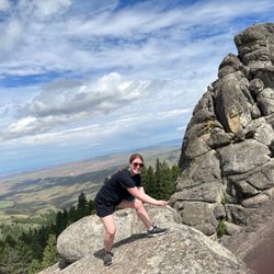
Great short hike to the falls. But they do have longer uphill trails that have great view of the farms below. Cell reception at the top and s crystal clear! read more


9 years ago
Worth the drive from Boise! It was a little tricky to find because the roads are not all clearly marked. Some tips before you go- bring shoes you don't mind swimming in. The floor of the swimming hole is covered with rocks, big and small. Painful to walk on. There water is very cold until you go numb. Shade is limited! Wished I had an umbrella. Bring bug repellent! The hole has bugs that will bite you repeatedly. I watched a bug land on my friend bite, jump somewhere else, bite again.. The repellent seemed to help after applied. I found detailed, accurate directions on world of waterfalls site. My GPS was not useful once I got to the unmarked roads and the parking lot is not visible until you arrive so there are no landmarks to aim for. There are two parking lots. If you are there to swim, I recommend you drive past the first lot, down a narrow road to the lot below. read more


8 years ago
The permissible hours of the Jump Creek Recreation area are STRICTLY enforced. An Owyhee County Sheriff officer said this is because of criminal and/or dangerous incidents that have occurred here in the past: accidental death, officer impersonation, attempted kidnapping, etc. The current fine for trespassing off-hours is $156 and I've heard the judge rarely dismisses them, regardless of the reason. Several times I've seen an Owyhee County Sheriff truck parked above the parking lot waiting to issue tickets to anyone who lingers beyond the closing time. I posted a pic of the hours sign. Although it is large it can be easy to miss on the drive in if you're not looking for it. That being said, the area is lovely during daylight, although it is popular. A lot of families, groups of teens, and young adults frequent here. Most users leave no trace, but you will likely see some litter. It's a short, easy hike to the falls/swimming hole. Some sections of the trail are sandy and it's easy to slip .. watch your footing. The drive to the area is beautiful, particularly in the Spring. The falls are bigger in the Spring as well, however the trail is likely to be wet and therefore slippery so be careful. read more

I've only hiked this trail one time before, and it was fantastic. I had no clue that something like this was just an hour outside of Boise! Right when you pull up to the parking lot, you'll see a little trailhead that leads to the waterfall. As you start walking towards the waterfall, the trees will begin to make a sort-of ceiling/canopy (it's majestic!). After a few hundred feet you'll arrive at a stunning waterfall with a little pool of water underneath it! There are various places to hike around here, but (here is my safety-patrol side coming out) be very careful and pay attention to where you are! There are steep ledges next to some of the paths and poison ivy surrounding a lot of the trails. I'm not saying it's super dangerous (I felt safe when I hiked around here), but I am saying you should pay attention to where you are! You can hike pretty high up with not a whole lot other than awareness of your surroundings to keep you safe. **Safety Rant Over** While on the hike you'll find stunning views, gorgeous green trees, streams/creeks of water, and of course, the waterfall! Even if you have no interest in hiking around, it is worth it to come out this way just for the waterfall and to take a dip in the pool of water at the bottom. Note on the 'gorgeous green trees': some of them are poison ivy. PROTIP (that a nice family told me while I was hiking): if poison ivy is blocking your path, step on it at the root and it will cause the plant to bend out of your way without it actually touching you! **Had I not gone on this adventure with a friend, I probably would have gotten lost trying to find my way here, so I wrote down some here to help you make sure you're going the right way: Hop on the I-84 W, take exit 33A to ID 55N/Nampa/Marsing, continue on to US 95N, left on Cemetery Rd, left on S Jump Creek Rd, turn right on Jump Creek Rd, and follow it to the trailhead/parking lot!** read more


Nature at its finest. It's easy to locate and there is an easy path to get there. It is a very beautiful walk that ends in the canyon at the base of the water fall. I recommend some sort of water shoes if you plan on going swimming because the rocks are sharp. Stay on the path as there is a lot of poison ivy in the area. read more


7 years ago
8 years ago
More info about Jump Creek
S Jump Creek Rd
Marsing, ID 83639
Directions
(208) 896-5912
Call Now
Visit Website
https://www.blm.gov/visit/jump-creek
Hours
Indoor Amenities
Outdoor Amenities
Ask the Community - Jump Creek
Review Highlights - Jump Creek


Why does Yelp recommend reviews?
1 review that is not currently recommended
The reviews below are not factored into the business's overall star rating.
8 years ago
Jump Creek - hiking - Updated June 2026
Best of Marsing
People found Jump Creek by searching for…
Things to Do in Marsing, Idaho
Dog Friendly Parks in Marsing, Idaho
Places to Take Pictures in Marsing, Idaho
Off Road Trails in Marsing, Idaho
Walking Trails in Marsing, Idaho
Swimming Lakes in Marsing, Idaho
Parks for Kids in Marsing, Idaho
Swimming Holes in Marsing, Idaho
Hiking Trails in Marsing, Idaho
Secret Spots in Marsing, Idaho
River Swimming in Marsing, Idaho
Waterfall Hike in Marsing, Idaho
Cliff Diving in Marsing, Idaho
Trending Searches in Marsing, ID
Browse Articles
Browse Nearby
Browse Brands
Related Searches in Marsing, ID
Best Fishing Locations and Guides in Marsing, Idaho
Best Places for Horseback Riding in Marsing, Idaho
Check Out Off Road Trails in Marsing, Idaho
Discover Popular Photo Spots in Marsing, Idaho
Discover the Best Night Hike Trails in Marsing, Idaho
Enjoy Camping Adventures Around Marsing, Idaho
Enjoy the Best Family Activities in Marsing, Idaho
Enjoy the Best Walking Trails in Marsing, Idaho
Experience Stunning Sunset Views in Marsing, Idaho
Explore Beautiful Parks and Green Spaces in Marsing, Idaho
Explore Bike Rentals Throughout Marsing, Idaho
Explore Easy Hikes Perfect for All in Marsing, Idaho
Explore Free Things to Do Around Marsing, Idaho
Explore Jet Skis for Sale or Rent in Marsing, Idaho
Explore Popular Campgrounds Near Marsing, Idaho
Explore Popular RV Parks Around Marsing, Idaho
Explore Popular View Points Around Marsing, Idaho
Explore Scenic Lakes to Visit in Marsing, Idaho
Explore Secret Spots Worth Visiting in Marsing, Idaho
Explore Top Dog Parks in Marsing, Idaho Near You
Explore the Best Boating Spots in Marsing, Idaho
Explore the Best Swimming Holes Around Marsing, Idaho
Family Friendly Hiking With Kids in Marsing, Idaho
Find Fun Kids Activities Outdoor in Marsing, Idaho
Find Fun Things to Do With Kids in Marsing, Idaho
Find Top Dog Swimming Spots in Marsing, Idaho
Find Top Skate Parks in Marsing, Idaho for All Skill Levels
Find Top-Rated Disc Golf in Marsing, Idaho
Find the Best Parks for Picnics in Marsing, Idaho
Find the Best Playgrounds to Visit in Marsing, Idaho
Find the Best Scenic View Locations in Marsing, Idaho
Find the Best Swimming Pools in Marsing, Idaho Today
Have Fun at a Splash Pad in Marsing, Idaho
Off Leash Dog Hiking Trails in Marsing, Idaho
Perfect Spots to Watch Sunset in Marsing, Idaho
Plan a Scenic Drive Route Near Marsing, Idaho
Popular Fishing Spots to Explore in Marsing, Idaho
Popular Kids Activities in Marsing, Idaho
Popular Places to Take Pictures in Marsing, Idaho
Popular Things to Do in Marsing, Idaho
Popular Things to See in Marsing, Idaho
Relax at Natural Hot Springs Near Marsing, Idaho
Safe and Fun Parks for Kids in Marsing, Idaho
Top Climbing Spots and Gyms in Marsing, Idaho
Top Paddleboarding Activities in Marsing, Idaho
Top Playgrounds for Kids to Enjoy in Marsing, Idaho
Top Running Trails to Explore in Marsing, Idaho
Top-Rated Boat Rental Services in Marsing, Idaho