Dedication Point Photos


You might also consider
More like Dedication Point
Recommended Reviews - Dedication Point
Start your review...

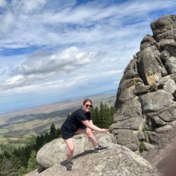
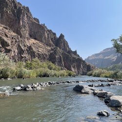
Wow, the view at dedication point was amazing! It's a great place to birdwatch and a nice place to just go and destress. The view from above looking down at the River is breathtaking. It takes about 5 min to walk from the parking lot to the overlook. Restrooms nearby. We saw some coyote tracks, but didn't see any unfortunately. read more


Whoa, talk about unexpected! We were driving around Kuna at possible new houses and saw a sign for Swan Falls. Being new to the area and having a free day, we said sure, let's explore! Explore we did...16 miles out of Kuna (or somewhere around Kuna), there pops up a bathroom and parking lot. You can walk under 1/4 mile to have a beautiful overlook of what I believe to be the Snake River Valley. The trail is rather easy, a bit narrow but no elevation gain, rather level and straight forward. If you choose to continue on, there are several other trails that twist around. A sign said there would be badgers, birds, big cats...We saw no wildlife, except for the few hooligans camping down the valley. Speaking of, if you drive another 6 miles, you can see the Swan Falls Dam and there seems to be a boat ramp as well as camping! read more


More info about Dedication Point
S Swan Falls Rd
Melba, ID 83641
Directions
Hours
Outdoor Amenities


Dedication Point - hiking - Updated June 2026
Best of Melba
People found Dedication Point by searching for…
Walking Trails in Melba, Idaho
Camping Cabins in Melba, Idaho
Running Trails in Melba, Idaho
Beautiful Views in Melba, Idaho
Off Road Trails in Melba, Idaho
Free Campgrounds in Melba, Idaho
Places to Swim in Melba, Idaho
Off Leash Dog Hikes in Melba, Idaho
Scenic Overlook in Melba, Idaho
Waterfall Hike in Melba, Idaho
Parks and Recreation in Melba, Idaho
Camping & Campsites in Melba, Idaho
Trending Searches in Melba, ID
Boat Rental near Dedication Point
Fishing Spots near Dedication Point
Photo Spots near Dedication Point
Places To Take Pictures near Dedication Point
Scenic Drive near Dedication Point
Splash Pad near Dedication Point
Strawberry Picking near Dedication Point
Swimming Holes near Dedication Point
Swimming Lakes near Dedication Point
Browse Articles
Browse Brands
Related Searches in Melba, ID
Best Fishing Locations and Guides in Melba, Idaho
Best Off Leash Dog Parks in Melba, Idaho
Best Spots for Star Gazing in Melba, Idaho
Check Out Off Road Trails in Melba, Idaho
Discover Dog Friendly Trails to Explore in Melba, Idaho
Discover Lakes & Ponds to Explore in Melba, Idaho
Discover Popular Bike Trails in Melba, Idaho
Discover Popular Photo Spots in Melba, Idaho
Discover Top Nature Parks to Visit in Melba, Idaho
Discover a Hiking Trail in Melba, Idaho
Discover the Best Night Hike Trails in Melba, Idaho
Discover the Best Running Track in Melba, Idaho
Dog-Friendly Hikes With Dogs in Melba, Idaho
Enjoy the Best Night View Spots in Melba, Idaho
Enjoy the Best Walking Trails in Melba, Idaho
Experience Stunning Sunset Views in Melba, Idaho
Explore Beautiful Parks and Green Spaces in Melba, Idaho
Explore Easy Hikes Perfect for All in Melba, Idaho
Explore Popular Campgrounds Near Melba, Idaho
Explore Popular RV Parks Around Melba, Idaho
Explore Popular View Points Around Melba, Idaho
Explore Secret Spots Worth Visiting in Melba, Idaho
Explore Top Dog Parks in Melba, Idaho Near You
Explore the Best Swimming Holes Around Melba, Idaho
Explore the Best Trail Options in Melba, Idaho
Family Friendly Hiking With Kids in Melba, Idaho
Find Beautiful Views in Melba, Idaho
Find Fun Kids Activities Outdoor in Melba, Idaho
Find Parks and Recreation Activities in Melba, Idaho
Find Top Dog Swimming Spots in Melba, Idaho
Find the Best Parks for Picnics in Melba, Idaho
Find the Best Playgrounds to Visit in Melba, Idaho
Find the Best Scenic View Locations in Melba, Idaho
Find the Best Swimming Pools in Melba, Idaho Today
Have Fun at a Splash Pad in Melba, Idaho
Off Leash Dog Hiking Trails in Melba, Idaho
Picnic Areas With BBQ Pits Available in Melba, Idaho
Plan Nature Center Visits in Melba, Idaho
Plan a Scenic Drive Route Near Melba, Idaho
Popular Fishing Spots to Explore in Melba, Idaho
Popular Picnic Spots to Visit in Melba, Idaho
Popular Places to Take Pictures in Melba, Idaho
Popular Things to Do in Melba, Idaho
Safe River Swimming Areas in Melba, Idaho
Safe and Fun Parks for Kids in Melba, Idaho
Top Playgrounds for Kids to Enjoy in Melba, Idaho
Top Running Trails to Explore in Melba, Idaho
Top Swimming Lakes to Enjoy in Melba, Idaho