Cancel

Open app

Search

Jordan and SLC Canal - Midvale

4.0 (1 review)

Jordan and SLC Canal - Midvale Photos

You might also consider

Recommended Reviews - Jordan and SLC Canal - Midvale

Your trust is our priority, so businesses can't pay to alter or remove their reviews. Learn more about reviews.
Yelp app icon
Browse more easily on the app
Review Feed Illustration

6 years ago

Helpful 0
Thanks 0
Love this 0
Oh no 0

You might also consider

Verify this business for free

People searched for Hiking 2,263 times last month within 15 miles of this business.

Verify this business

Bell Canyon - Stream

Bell Canyon

4.4(43 reviews)
5.3 mi

Everywhere I look these days, it seems that people are posting pictures of amazing fall colors. We…read moredo live in a beautiful state and it's appropriate for us to step outside, take a look around and appreciate when nature shows off. I joined a group of hikers and hit the trails this past week, in search of some great fall colors. Bell Canyon did not disappoint. There is plenty of parking at the trailhead, including clean bathrooms. The first part of the trail is pretty rocky and has a decent elevation gain-poles are helpful, but at the least, have good shoes with some traction. Once you get to the reservoir, it's pretty flat and there are lots of places you can get amazing pictures. Be sure to take some time down by the water-it's so calming and just beautiful. There were some detour signs on the trail, so we didn't get the full experience (not sure why it was closed, but we tried to follow signs until they suddenly stopped. So we turned around and came the way we went.) Overall, it's a beautiful hike and I'd love to come try it again when the trail is open.

We started at the entrance on Wasatch Blvd near the residential area; and then, ended up at the…read morewaterfall. It took us about 4 hours to hike approx. 6 miles with short breaks in between for water. It's a mixer of flat, incline, rocky, slippery (snow still out towards end of hike), upward steps, and mini bridges to cross over small water streams. There are surrounding plants and trees, but most are barely blooming. Didn't see any wildlife animals, but saw a few squirrels crossing our paths lol. The hike itself wasn't too hard. I'd rate it intermediate. It was only challenging because the paths towards the end were slippery due to snow still out and melting. It was fun with some close calls. Luckily I found a stick on the way to use. We passed by the lake at the beginning of the hike, which was nice. Once we reached the waterfall, we took a refreshing break; snacked a bit; embraced the beautiful nature; and then, headed back where we started. It was harder to hike down the slippery snow than it was to hike to the waterfall. I'd come back to hike this place during fall to see the vibrant color of the trees.

Photos
Bell Canyon
Bell Canyon
Bell Canyon - The universe sent me here

See all

The universe sent me here

Murray Canal Trail - History of Canal

Murray Canal Trail

5.0(3 reviews)
1.9 mi

Great hidden trail in Murray/Holladay. Dog friendly and people friendly. Next to riverread more

I've walked this trail in its entirety only one time, about a year ago, in the Spring sunshine. I…read morestarted at Wheeler Farm and walked, crossing 1300 E, and then continued until the end, passing church farms, backyards, fences, trees, and large fields. I have, however, hiked small portions of this on many occasions. I have lots of fond memories of finding grapes growing along fence and throwing them to catch, of giant clouds of gnats in late Spring, of wildlife, of good conversation, and of leaving the trail to investigate the surrounding neighborhoods. Lately, I've been hiking the very small section of this trail that runs behind Wheeler Farm. The pup and I have been making it a habit to come here and sniff all the things (that's mostly her job) and to get out and enjoy the post-rain, pre-summer gorgeous days. It's entirely flat, and most sections are plenty wide for the dog walkers, runner, strollers, and other people you'll for sure see. The Wheeler Farm part is the most crowded, but follows the creek after ditching the canal and is pretty lovely. It does get buggy from early evening on, after about May (?) so if you're running, you can either move side to side to skip the column, or just run through. Lovely for a walk, it feels a little like you've discovered a secret passageway through the middle of the valley.

Photos
Murray Canal Trail - Part of the trail

Part of the trail

Murray Canal Trail
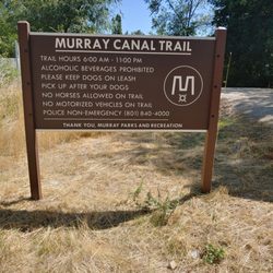
Murray Canal Trail - Rules

See all

Rules

Ferguson Canyon - Lots of rocks

Ferguson Canyon

4.0(8 reviews)
5.1 mi

This trail on the southeast side of town is beautiful, well shaded, and right along a stream. The…read moretrailhead is in a neighborhood. There are some parking spaces flanking the trail, and overflow parking down the street. Other parking along the street is permit only, with warning signs that threaten fines and towing without notice. A paved ramp and amphitheatre sit trail adjacent. The beginning of the trail looks tame and fairly pleasant (except for all the dog poo bags littered about; carry the poo out, people). But don't be fooled! It quickly turns rocky and the are some steep areas. After rain, the sandy spots can be a bit slick. The bubbling water and shade are quite pleasant on a hot day. But it can be a bit buggy. I was bitten by what looked to be some black flies and mosquitoes. The trail isn't well marked and there are a few offshoots that lead in different directions. Some parts seem narrow and overgrown. For the most part, follow the water to stay on the trail. I didn't see many people. Most people appeared towards the beginning of the trail; most with dogs off leash. A nice trail for respite from the sun, but is not really a beginner's trail. Footwear with good grip and ankle support recommended.

Oh man if you are looking for a challenging hike this one is for you…read more I had no idea this trail even existed so close to the city until, I ran across a review from an old friend of mine on google maps. Cool that there is a hike that's close to the city and is dog friendly. I used google maps to get me to this hike. It's in a neighborhood, and has very limited parking. There isn't parking on the street in front of the houses, unless you have a permit, your car will be towed. (there is overflow parking about a block or so down the street) Now back to the trail review... At first the trail is pretty easy, and I had my dog on a leash obeying the signs. Pretty quickly the trail starts to get a bit rocky, and you run into some make shift stairs going down closer to the river, which you can hear right away. Then the elevation gain starts, and doesn't end until you come down from your hike. The trail is beautiful, and has a good amount of shade and water. The trail is not well defined as far as signage goes. At one point I came to a stand still because I didn't know where to go. The trail I was on came right up to the river, and I couldn't see a trail beyond if you crossed it, and there definitely wasn't a defined trail to my right. I thought what do I do now cross the river? Thankfully a family with small children came around the rocky bend and I asked them which way to go. They said they always take the rocky way through the river. It's a good thing I had my hiking boots on. Most of this hike is ROCKY, climbing over boulders and very large rocks on very sandy soil. It didn't help that it rained this morning. I was slipping and sliding. At this point I took my dog off her leash. It's not in your best interest or the dogs to be dragged on this rocky trail ,with a leash around it's neck, getting pulled here and there. There was one point on the trail that was almost a 99% vertical climb that I sat down with tears in my eyes. I was scared. I kept thinking I have to come down this when I turn around. I should just turn around now, but I wanted to finish to the end to feel a sense of accomplishment. There are no switchbacks on this trail that would have helped with this section, so I made my own, and got past this section. I was holding on to what I could and said "I don't care if there are any snakes I have to get out of here". (as luck would have it there wasn't any, I think I would have passed out if there was coming face to face with a rattler) Each part of the trail became more beautiful, and more changeling. I ran across a section where you could tell a rock slide happened, and you just kept climbing over the boulders. "I can make it, I know I can." There were two sections that you have to walk through the river to continue on the trail. I don't know how the river is at any other time of the year, but it wasn't rushing so fast that you couldn't pass it if you want to go to the end. You have to pass it. I logged on the the all trails app to make sure I was on the trail. It said I was and I only had a little ways left to go to the end. Rain clouds were forming and I thought I better turn back because the trail was slippery enough I didn't need to be caught on the trail when it was a down pour. Plus my little doggy was doing this trail as well, I had to think of her too. There was hardly any people on this trail today, but when I did run across any, they had younger kids with them. Mind you All Trails has this trail rated as Hard. The rain clouds started to form so I turned around. I have to say it was easier to come down than it was to go up. When I came down I ran into a couple of people learning how to mountain climb. I guess this is a popular spot to do that. I would like to go back, and climb all the way to the top. Next time I'll know what to expect, but seriously doubt I'll make it.

Photos
Ferguson Canyon - Trailhead

Trailhead

Ferguson Canyon - Walking along the stream is beautiful but rocky.

Walking along the stream is beautiful but rocky.

Ferguson Canyon - Sandy trail can be slick after rain, especially on the steeper parts.

See all

Sandy trail can be slick after rain, especially on the steeper parts.

Jordan River Parkway - Midvale 7800 South Trailhead

Jordan River Parkway - Midvale 7800 South Trailhead

4.0(2 reviews)
1.9 mi

I've been wanting to come here for years, and I don't really think about this trail, until I pass…read moreit going somewhere else, as was the case tonight. I was on my way to the West Jordan Park to walk the dogs, but in a "blink of an eye" decision made a sharp turn, when I was right upon the parking lot. This parking lot is very small, and virtually impossible to cross the street when it's rush hour. I had no problem crossing tonight as it was dusk, and there was hardly any traffic. It's now 2019 and Midvale City hasn't taken the best care of this trail. Could it be budget constraints? We started out right at dusk with just enough light to head on down the trail. This is a scary trail on the East side of the river. There is absolutely NO light except for the Moon. This side of the river is all blacktop, and isn't fun to walk on for long stretches, after a few miles, your knees, and back start hurting. There were several runners that came upon us all of a sudden due to the overgrowth of the bushes and trees. You can't see or hear the river except at the beginning of the trail head. I didn't see anywhere to sit, and ponder, or enjoy the trail except for two small (seats 4) picnic tables and the beginning of the trail. I wouldn't sit here, they have been neglected, and overrun by weeds. At the beginning of the trail there is a doggy bag stand that also has been neglected. No doggy bags available. (I usually bring my own, but it's nice to have this available, just in case) I didn't see a way to walk to the river except crossing the bridges. The first bridge you come to has major repair needs. It reminds me of a patchwork quilt. There are planks coming loose, and some are sticking up. They have put down particle boards so you wouldn't fall through to the river. The second bridge was in better shape with no boards sticking up. As the sun kept going down, and down we continued on until it became so dark I couldn't really see except for the bikers that had a light on their bike. Not much traffic tonight on the trail. It was scary when all of a sudden someone was walking up behind you. Maybe, during the daylight, I will walk across the bridge, and check out the other side of the river trail. Until then, I'll stay on a trail that I feel safe on.

Ask nearly any local about the Jordan River, and you're probably not going to summon a lot of love…read more But every time I visit, I wonder why in the world that is. We have a really incredible resource running right down the center of the Salt Lake Valley, and serious time and effort has been put into making it accessible and fun for everyone. I'll save the rest of the love I have for the review of the whole parkway, which is found elsewhere on Yelp. What you should know, at the very least, is that it's continuous (mostly) trail that runs from Utah Lake to more or less the Great Salt Lake (via the Legacy Parkway Trail and the Denver & Rio Grande Western Rail Trail). All told, that system of trails is 76 miles long and is only a few patches shy of being completely paved (meh) but offering loads of recreation and open space. So, let's talk about this trailhead in Midvale. It's the one I've used most, and I really like the openness of it. The more popular area here is on the south side of 7800 South, just to the east of the river. The parking lot is only accessible from the eastbound lane, as the westbound median blocks would-be left hand turners. Once you arrive in the parking area, you've got an oddly shaped L lot, with several parking spaces including wheelchair accessible reserved spots. Technically, the Parkway proper doesn't connect to this parking lot, but rather the small section of trail from the parking lot to the large bridge is a "spur trail" and the trail proper follows the west bank of the river. Things get a little confusing, so have a map handy if you're out for a long hike. If you're heading south, go to that first bridge, and then continue on the east side of the river. Further south there's another bridge crossing and you'll take that to the right (west) if you want to stay on the official trail. Instead of crossing, however, you can continue on the east side of the river, follow the big bend, and eventually you'll pop out on 700 West in a semi-industrial area. This is always a nice out-and-back option that I often take. The river has some interesting pools and fishable sections down here, as well as lots of ducks. If you're parking here and headed north, you'll have to first go south to that first bridge, cross, and then head back north. You'll see the underpass, pass through, and you're off and running to the north, now on the western shore of the river. Back near the parking area, there are picnic tables aplenty. It would make a fine spot to eat a meal. There is also a Trailhead in Midvale at 7200 S, and lots more dining options there, but I prefer this trailhead, so you could drive down 700 W with your food, park, and enjoy food with a view. I used to come here in the wee hours of the morning for dog walks and didn't see too many people, especially in winter. As it's paved, it makes for a good run. On warmer nights it's full of people, families mostly, and is hugely popular with the bicycle crowd. One word of caution: I don't love the security situation here. It's a dark trail, but in the middle of the city. The parking lot is full of piles of broken glass that makes me think it's a popular place for smash n' grab punks. I've never personally had a problem, but I would not leave any valuables in my car here, and I would look for a walking partner in those early morning/evening hours. In the name of caution. The Jordan River has its problems, but we live so close to a really wonderful little piece of nature, and this access point has a lot to like.

Photos
Jordan River Parkway - Midvale 7800 South Trailhead

See all

Jordan River Parkway Trail

Jordan River Parkway Trail

4.3(10 reviews)
3.3 mi

This is a review from my 20 mile ride on the JRT…read more I started with the intention of just riding to the gym and back... it was 5 miles door to door. This was my first ride in over a year so I should have gone home. No gloves, no padded shorts, one water bottle. I usually ride with three Liters of water. I was feeling good so pressed on with a round trip goal of 20 miles. The trail, in my area, is clean, devoid of trash or dumped garbage. Refreshing and peaceful. Very quiet. Mostly runners, mountain bikers, walkers and the occasional E Bike... maybe going faster than they should but I'm not the Park Ranger. The trail runs under the road in the trailI traveled so there is never the risk of getting hit by a car. In Vegas they have bike lanes but the road is shared and bikers are in constant danger of being hit. This JRT makes me feel safe. Along the way there are businesses in view so if you wanted to take a break or needed assistance resources were not far away. People I encountered were friendly. I saw beavers in the river and a deer. I got a vigorous workout and should have taken it easier on my first ride in a long time but it was so gorgeous out. If your curious about riding the JRT Through Draper I highly recommend it. Safe, beautiful and clean there's no reason I shouldn't get back in shape riding the JRT. Thank you for making this trail available for recreation. NOTE! If you have a road bike, I don't recommend as there are a lot of turns to maneuver.

I rode the trail from the South starting at Taylorsville going north to Salt Lake City. I had to…read moreturn around at the Utah State Fair park due to the homeless blocking the trail, garbage, and I felt unsafe. Glass, garbage and tents were abundant north of the Japanese Gardens. The Japanese Gardens were very nice. If your downtown Salt Lake City on the Jordan River Trail be careful. Nothing like ride by a guy squatting on a Home Depot bucket taking a dump. Somebody is going to get hurt. Road the trail south the next day 15 miles from Taylorsville, very nice that part of the trail gets 5 stars.

Photos
Jordan River Parkway Trail - Warmed up to 40 degrees today, lovely snow capped mountains

Warmed up to 40 degrees today, lovely snow capped mountains

Jordan River Parkway Trail

See all

Jordan and SLC Canal - Midvale - hiking - Updated May 2026

Loading...
Loading...
Loading...