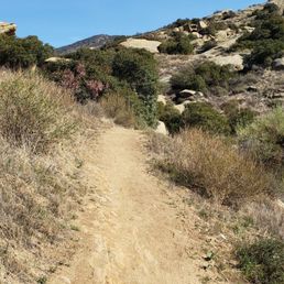
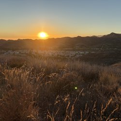
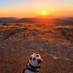
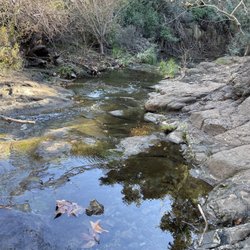
Hummingbird Trail Photos


You might also consider
More like Hummingbird Trail
Recommended Reviews - Hummingbird Trail
Start your review...

Reviews With Photos

It was a hard one. Very tricky to find the hidden swing but worth it. 3 miles took us 3hours including rests and getting lost. The cave is by the cliff and you need a good gripping trail or hiking shoe. Very dangerous when windy. I do not recommend to hike this in a rainy day or foggy morning.

Just a heads up, AllTrails rated this as hard probably because there are areas where the incline/decline could be pretty steep. This trail is also not shaded, so please bring enough water and wear proper shoes and clothing. If you are only interested in getting to the Swing Cave, then I would suggest going clock-wise because it makes the hike much shorter. However, going clock-wise does lead to a steeper uphill hike so please carefully examine your body condition and physical fitness before deciding which direction to take. By taking the clock-wise path, I reached at the second fork road about 1 mile in; the left path leads to the main trail whereas the right path leads to the Swing Cave. Please refer to the attached images for the exact location. As of today, there weren't a lot of arrow marks on the ground/rocks so I think it would be really helpful to have a trail map downloaded onto your phone. Pay attention to your left as you approach the Swing cave, there should be a path leading down to an area where there are ropes/chains attached to the wall (The ropes will be on your right hand side). Climb around it and follow the path till you see a swing on your right and a ladder leading up to the Swing Cave. There weren't a lot of hikers on a Saturday afternoon, but there were plenty of bikers around. Please pay attention to the surrounding to avoid accidents from happening. Overall, it was a really fun hike. I'm glad I made it here before the summer heat arrived!

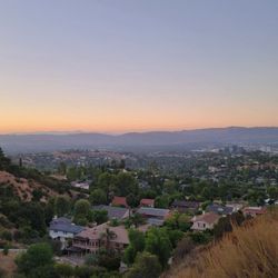
Every time I come to hike this trail I always discover something new. I first found out about Hummingbird Trail when I noticed the trail marker while hiking Rocky Peak. My first couple times hiking here I always thought it was a mile to mile and a half out and back trail up the hill to lookout over Simi Valley that has a bunch of crossing paths made by the mountain bikers. Turns out there's actually a 4 mile loop that you can navigate on the All Trails app. There are trail markers out here but with all the random paths formed by mountain bikers it's easy to wonder off the main trail and not notice. The trail goes up around 1,300 - 1,500 feet of elevation gains. The incline climbs on the trail can be difficult, but it's doable for beginners as long as you come prepared. Make sure you have some good hiking/trail shoes with grip, parts of the climb up will be on a rock and the dirt around there slides pretty easily. Also be careful when you're hiking this trail on a windy day, the mountains over in the chatsworth & Simi Valley area have a lot of windy days in the fall/winter season and the gust are very strong on this trail. Last tip, if you're looking for the cave with the swing, follow the white spray painted arrow & bunny and be prepaid to use a rope to guide you down to the cave area. Oh wait one more thing, those parking signs by the trails make zero sense, I've parked in between where the other cars have an luckily haven't gotten a ticket so far, but there's also kind of a dirt lot on the street before the trail so that's also an option.

Arrived yesterday Saturday around 3pm and parking was available. While there were others hiking, it was not crowded at all. As others have said, come prepared with hiking boots and poles, lots of snacks and lots of water if its a hot day. Parts of the trail are steep and uphill with many rocks to get over. There are many trails or ways to get to the cave as other hikers told us. We never found the cave. It's around 2-2.5hrs one way. It takes some time to figure out which trail to take and how to carefully make your way up and over the rocks. Its clean but no restrooms. The views of the valley and sunset were awesome! I would come back much earlier and attempt a second shot at finding the cave. Not finding it was a disappointment. There were "markers" along the way and then they stopped. Someone sprayed arrows on rocks or "keep going". There is a large "Merry Christmas Family" in blue spray paint. We made it past that but like I said didn't find the cave... Found other much smaller caves along the way.

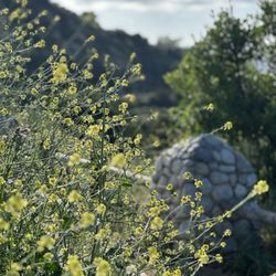
Doesn't look like must off the 118 fwy but boy does this trail pack a punch. Just the next exit from rock peak road, you approach a wild field that just looks bare. Almost like a wild field, could be perfect for photos. Just off the freeway, you approach the begging of the trail. Which is at the end of the road. On one side, there's a newer community of homes and then the trail. First off, it was my first time here so I wasn't sure with the parking situation. It's street parking but some of the signs were pretty confusing. But plenty of cars were parked so I went with it. The begging of the trails has the name so you know where you are. Starting off on a dirt trail, there's plenty of greenery everywhere you look. Also, at the beginning, there were lots of people on their dirt bikes jumping the hills. The trails are marked with signs letting you know where to go. Just with all the rain seven been getting. The hills are covered with colorful wild flowers blooming left and right. The path leads you toward the top of all where the huge boulders are of Simi Valley. There's plenty of paths so I'm not sure where they take you. I mainly stayed on the main market path. Toward the top, you end up on huge boulders that over looks Simi Valley. Beautiful site. There were lots of little hidden caves. Be careful as some of the rocks has the sudden drop from where your standing. We continued on the main trail going higher but didn't know where or if it ends. Plenty of people of mountain bikes passed us by. Great trail, pretty easy. Beautiful scenery.
I arrived on a Saturday morning around 9am to a surprise. No parking. The parking lot there is actually quite small and was already full. I saw a long line of cars parked on the street across from the parking lot that had signs saying "no parking." Was hesitant to chance it so ended up driving past the freeway and parking in a residential area. It was worth the extra walk. Coming back from our hike we noticed every car had an envelope on their windshield...I'm assuming parking tickets. Hummingbird trail can take you to a cave and swing if you go off the path. It's about 3 miles to the cave with a very steep climb and some rock scrambling. One section you will need to grab onto the rope. The hike is fairly difficult. Make sure to have hiking shoes on. There are trail markers when you start then follow the white arrows, photos of rabbits and signs that say apes. I thought since this trail was rated difficult it would be a COVID safe hike with very few people. Again wrong. Upon arrival to the cave there were quite a few hikers and many not wearing masks and just hanging out in the cave. We kept ours on and quickly took a photo and left. Seems like a popular hike so if COVID safety is a concern for you not quite sure what day/time to best recommend. Overall the hike was nice. It was something different to see and the rock formations were unique.

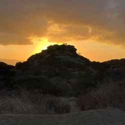
I've had Hummingbird Trail on my bucket list for years now and I'm so happy I finally got to check it off today! What an amazing, beautiful and challenging hike. Getting to the trailhead is pretty easy. Just type "Hummingbird Trail" or this address into Waze: 2409 Kuehner Dr, Simi Valley, CA 93063. There's a tiny parking lot to the left, just before the trail entrance. I noticed there were some cars parallel parked along Kuehner Drive. So - the actual Hummingbird Trail is about a 4 mile loop, however after speaking to a few hikers on the trail, I found out the loop trail does not lead to the "secret swing" in the cave. If you want to do the Hummingbird Trail loop, simply follow the official trail markers. BUT - if you want to get to the secret swing, that's a bit tricky; you'll have to veer off the official trail about half way up the mountain. When you see the arrow, that's where you start going up the middle of the mountain (I snapped a pic of the arrow - it's the photo with my shadow). You'll have to climb boulders and hiking steep inclines. I highly suggest wearing hiking boots. I was not prepared - the climb is doable with sneakers, but I would have preferred my hiking boots. It would have made the climb easier. I consider myself an avid hiker and athletic; I found this hike to be challenging. When you start seeing the blue ribbons, you know you're heading in the right direction. You'll also notice the graffiti directing you to the swing. The last part before the swing requires climbing down a steep ropes section. It's a little sketch, but it's not bad. Literally only a few hundred feet of rope and voile, you'll be at the cave. There's a ladder to assist in getting up to the cave - be careful as it's not bolted down. The view from the graffitied cave is nothing short of absolutely gorgeous, breathtaking and even a little terrifying at times. Not gonna lie, the swing is a bit sketch but I faced my fears by hopping on it... wait a minute.. Ha, let's be real - uh rather, faced my fears for the 'gram, right?! In all seriousness, fear can limit your success - when hiking, at work, at school or whatever it is you want to accomplish - so it's always best to face your fears and overcome them. I am happy I faced my fears while getting some great pics and creating memories. If you plan to do this hike, I highly suggest planning it out so you'll be hiking back down just before sunset. G-O-R-G-E-O-U-S!!! My sunset photos do not even do any justice. Absolutely gorgeous. If you love challenging hikes, I definitely recommend adding Hummingbird Trail to your bookmark list. Honestly, I can't wait to do this hike again.

Such a beautiful hike! But, you must prep and review the landmarks and FAQs, my friends and I learned the hard way after going 20 minutes in the wrong direction and passing the ropes to the secret swings. Be sure you use the restroom ahead of time, shoes that can track over the mud and water, and grab a secured hat (it's windy!) Overall, the trail was nice and peaceful. Makes you feel like you're in an anime at some point.

I did this Trail early on Friday morning there was plenty of parking no issues started at around 9:00 a.m. there is a dirt parking lot down from the trail which is the only place that you can park without getting a ticket if you park on the street you will get a ticket. The trail itself has a bunch of arrows which actually confuse you I was originally told to follow the arrows but the arrows aren't very helpful I had seen a YouTube video that actually explained it a lot better. Getting to the cave is a lot of incline which makes it a moderate Trail in my opinion just because of the rock scrambling that's required to get into the cave they do have a cable to help you down which makes it easier and a bit safer once inside the cave just enjoy swing on the swing take a couple of pictures for your Instagram and call it a day.

The parking area is free and there are no restrooms in the area. This is a nice trail with a steady incline. When coming back down it can be slippery due to the incline and dirt will not grip well. So just watch your footing. The beginning of the trail has a lot of posted trail signs, so getting lost is almost impossible. Just be aware as this is shared with mountain bikers. This is a good alternative to Rocky Peak trail head. But most people hike this side to find the hidden cave. Just pay attention, there are painted markings to go off trail when searching for this hidden cave. As always pack accordingly to the weather as there are no shades and it can be tough in the summer months.

Okay, I finally committed to Hummingbird Trail after the Rocky Peak Summit. First attempt, I went via Rocky Peak trail head, bad idea, didn't find the markings, just exhaustion and soreness from going all the way down to Hummingbird and then all the way back up to Rocky Peak. The second attempt, I went via Kuehner dr and parking wasn't bad. I initially missed it as I followed the trail signs and didn't notice the supposed white rabbit. A biker was kind enough to inform me I went all the way to the opposite side and needed to be all the way at the other side to start the part. The rock with the big white circle seemed a million miles away. Well, I ninjered my way through rocks and dirt because I was not about to go all the way back, long story short, I made it to the cave with graffiti markings and followed the signs. I will mention that some parts were confusing but I made it all the way to the cave. I have included several photos of various markings. MOST OF ALL, I have included a photo of the blue and red pill. Once you get to this spot, do not follow the trail mark, follow the part to your left. This is the beginning of the trail, look for the faded, mini white rabbit and ribbon on the branches. The cave itself is very interesting, it was nice and peaceful but I feel as I did the Rocky Peaks and Summit first, it was hard to get the breathtaking feeling already experienced at the Summit. I went down the marked part on my way down to ensure I viewed all the markings and see where I missed the turn. Overall, I had a fun and adventurous experience.

My co-workers went here and I decided to give it a try. It is actually a moderate to hard trail. But It was really beautiful and worth it 1. Parking-there's limited parking outside. You will get confused because it says "No Parking Anytime" together with "No Parking 10pm to 6am". I parked here twice already and I haven't got any ticket. There's also a parking lot near the residential area. 2. Dogs: if you have a medium to large size dogs, you're gonna have a hard time going to the cave. It's dangerous. But small dogs, you can carry on your backpack. 3. There's 2 ways to go to the cave. Shorter and longer version. You can download or check the map for this trail on google 4. Cave: I love it! We love it! I already went twice for this. Very lovely and creative. UNIQUE! There are hammocks and a swing. 5. You can get lost on the way. Just follow the arrows "white heart" and also "b2g crook" signs.

Definitely a challenging hike and unmarked after about 1/4 into it. There are no restrooms here or nearby. If you're hiking here to find the caves, it's a puzzle for sure. Start early in the morning, there is no shade and it gets warm quickly. There are no markings, even if you hear otherwise. I heard there was spray painted arrows or bunnies, none. The way to the caves is tricky and the best way to find them are to down load your map and use landmarks as your key. Watch a few You Tube videos as well. I used a few of the mountain peaks, boulders, and followed bike tracks to find my way. We got lost a few times but finally made it, found trip was about four hours. The parking is easy, at the end of a cul de sac. Watch for the parking signs and the trailhead is to the right , behind a white fence and along a fence for a short time. The incline of the hike start shortly after your last marker and continues for the remainder of the hike. The cables down are sturdy, you must look for them as they are not clearly visible. I never felt unsafe and the ladder at the cave is new and sturdy. Wear shoes with traction as coming down is very slippery and falling isn't hard to do. Bring water,sunscreen, and a hat and hike with a partner. Enjoy!

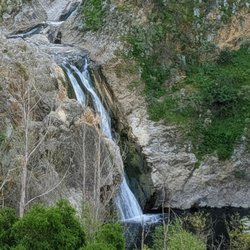
Unfortunately the hummingbird trail is not the same with the new housing development. And every time I visit these days the situation gets a bit worst: as the development limits entrance onto the trail. Once you get beyond the development you will be treated to some great hiking and boulder climbing if you choose. Still worth the visit: today I was in search of waterfalls after the rain storm, unfortunately just puddles of water. There were cute frogs though! read more


6 months ago
Parking: Looks like you can park on the street next to the entrance but not directly inside the culvasac. (This is what the locals do) Besides that, there is a gravel parking lot across the street from the new development, north west corner at the intersection of Mount Sinai and Kuehner Dr. Conditions: It has just rained and the trail was really washed out, there are a slew of mountain biking trails that are connected to the trail. All join about midway up the mountain. Definitely steep and requires some climbing. The rocks are a rough sandstone, so very grippy. Overall: Enjoyed it, views are great, it was overcast on my visit but could be very hot. You are in the direct sun for all of it. Would return, approximately 2-3 hours of hiking, depending on how curious you are. read more


9 months ago
It was a hard one. Very tricky to find the hidden swing but worth it. 3 miles took us 3hours including rests and getting lost. The cave is by the cliff and you need a good gripping trail or hiking shoe. Very dangerous when windy. I do not recommend to hike this in a rainy day or foggy morning. read more


Just a heads up, AllTrails rated this as hard probably because there are areas where the incline/decline could be pretty steep. This trail is also not shaded, so please bring enough water and wear proper shoes and clothing. If you are only interested in getting to the Swing Cave, then I would suggest going clock-wise because it makes the hike much shorter. However, going clock-wise does lead to a steeper uphill hike so please carefully examine your body condition and physical fitness before deciding which direction to take. By taking the clock-wise path, I reached at the second fork road about 1 mile in; the left path leads to the main trail whereas the right path leads to the Swing Cave. Please refer to the attached images for the exact location. As of today, there weren't a lot of arrow marks on the ground/rocks so I think it would be really helpful to have a trail map downloaded onto your phone. Pay attention to your left as you approach the Swing cave, there should be a path leading down to an area where there are ropes/chains attached to the wall (The ropes will be on your right hand side). Climb around it and follow the path till you see a swing on your right and a ladder leading up to the Swing Cave. There weren't a lot of hikers on a Saturday afternoon, but there were plenty of bikers around. Please pay attention to the surrounding to avoid accidents from happening. Overall, it was a really fun hike. I'm glad I made it here before the summer heat arrived! read more


: Turn around if you reached a rock with this heart (You've missed the turn down to the ropes) - Hiking Near Me - Simi Valley, California")
 - Hiking Near Me - Simi Valley, California")
 - Hiking Near Me - Simi Valley, California")
: Left leads to the main trail whereas right leads to the Swing Cave - Hiking Near Me - Simi Valley, California")
: Pay attention to arrows on the ground/rocks & the rock on the upper right hand corner. - Hiking Near Me - Simi Valley, California")
: Ropes leading to the Swing Cave - Hiking Near Me - Simi Valley, California")
: This is the right path/trail; just keep following the arrows/rocks upward - Hiking Near Me - Simi Valley, California")
: Ropes leading to the Swing Cave. It's not as scary as it looks in picture. - Hiking Near Me - Simi Valley, California")
Every time I come to hike this trail I always discover something new. I first found out about Hummingbird Trail when I noticed the trail marker while hiking Rocky Peak. My first couple times hiking here I always thought it was a mile to mile and a half out and back trail up the hill to lookout over Simi Valley that has a bunch of crossing paths made by the mountain bikers. Turns out there's actually a 4 mile loop that you can navigate on the All Trails app. There are trail markers out here but with all the random paths formed by mountain bikers it's easy to wonder off the main trail and not notice. The trail goes up around 1,300 - 1,500 feet of elevation gains. The incline climbs on the trail can be difficult, but it's doable for beginners as long as you come prepared. Make sure you have some good hiking/trail shoes with grip, parts of the climb up will be on a rock and the dirt around there slides pretty easily. Also be careful when you're hiking this trail on a windy day, the mountains over in the chatsworth & Simi Valley area have a lot of windy days in the fall/winter season and the gust are very strong on this trail. Last tip, if you're looking for the cave with the swing, follow the white spray painted arrow & bunny and be prepaid to use a rope to guide you down to the cave area. Oh wait one more thing, those parking signs by the trails make zero sense, I've parked in between where the other cars have an luckily haven't gotten a ticket so far, but there's also kind of a dirt lot on the street before the trail so that's also an option. read more


 but still a nice view. - Hiking Near Me - Simi Valley, California")


4 years ago
Arrived yesterday Saturday around 3pm and parking was available. While there were others hiking, it was not crowded at all. As others have said, come prepared with hiking boots and poles, lots of snacks and lots of water if its a hot day. Parts of the trail are steep and uphill with many rocks to get over. There are many trails or ways to get to the cave as other hikers told us. We never found the cave. It's around 2-2.5hrs one way. It takes some time to figure out which trail to take and how to carefully make your way up and over the rocks. Its clean but no restrooms. The views of the valley and sunset were awesome! I would come back much earlier and attempt a second shot at finding the cave. Not finding it was a disappointment. There were "markers" along the way and then they stopped. Someone sprayed arrows on rocks or "keep going". There is a large "Merry Christmas Family" in blue spray paint. We made it past that but like I said didn't find the cave... Found other much smaller caves along the way. read more


Doesn't look like must off the 118 fwy but boy does this trail pack a punch. Just the next exit from rock peak road, you approach a wild field that just looks bare. Almost like a wild field, could be perfect for photos. Just off the freeway, you approach the begging of the trail. Which is at the end of the road. On one side, there's a newer community of homes and then the trail. First off, it was my first time here so I wasn't sure with the parking situation. It's street parking but some of the signs were pretty confusing. But plenty of cars were parked so I went with it. The begging of the trails has the name so you know where you are. Starting off on a dirt trail, there's plenty of greenery everywhere you look. Also, at the beginning, there were lots of people on their dirt bikes jumping the hills. The trails are marked with signs letting you know where to go. Just with all the rain seven been getting. The hills are covered with colorful wild flowers blooming left and right. The path leads you toward the top of all where the huge boulders are of Simi Valley. There's plenty of paths so I'm not sure where they take you. I mainly stayed on the main market path. Toward the top, you end up on huge boulders that over looks Simi Valley. Beautiful site. There were lots of little hidden caves. Be careful as some of the rocks has the sudden drop from where your standing. We continued on the main trail going higher but didn't know where or if it ends. Plenty of people of mountain bikes passed us by. Great trail, pretty easy. Beautiful scenery. read more


5 years ago
I arrived on a Saturday morning around 9am to a surprise. No parking. The parking lot there is actually quite small and was already full. I saw a long line of cars parked on the street across from the parking lot that had signs saying "no parking." Was hesitant to chance it so ended up driving past the freeway and parking in a residential area. It was worth the extra walk. Coming back from our hike we noticed every car had an envelope on their windshield...I'm assuming parking tickets. Hummingbird trail can take you to a cave and swing if you go off the path. It's about 3 miles to the cave with a very steep climb and some rock scrambling. One section you will need to grab onto the rope. The hike is fairly difficult. Make sure to have hiking shoes on. There are trail markers when you start then follow the white arrows, photos of rabbits and signs that say apes. I thought since this trail was rated difficult it would be a COVID safe hike with very few people. Again wrong. Upon arrival to the cave there were quite a few hikers and many not wearing masks and just hanging out in the cave. We kept ours on and quickly took a photo and left. Seems like a popular hike so if COVID safety is a concern for you not quite sure what day/time to best recommend. Overall the hike was nice. It was something different to see and the rock formations were unique. read more


6 years ago
I've had Hummingbird Trail on my bucket list for years now and I'm so happy I finally got to check it off today! What an amazing, beautiful and challenging hike. Getting to the trailhead is pretty easy. Just type "Hummingbird Trail" or this address into Waze: 2409 Kuehner Dr, Simi Valley, CA 93063. There's a tiny parking lot to the left, just before the trail entrance. I noticed there were some cars parallel parked along Kuehner Drive. So - the actual Hummingbird Trail is about a 4 mile loop, however after speaking to a few hikers on the trail, I found out the loop trail does not lead to the "secret swing" in the cave. If you want to do the Hummingbird Trail loop, simply follow the official trail markers. BUT - if you want to get to the secret swing, that's a bit tricky; you'll have to veer off the official trail about half way up the mountain. When you see the arrow, that's where you start going up the middle of the mountain (I snapped a pic of the arrow - it's the photo with my shadow). You'll have to climb boulders and hiking steep inclines. I highly suggest wearing hiking boots. I was not prepared - the climb is doable with sneakers, but I would have preferred my hiking boots. It would have made the climb easier. I consider myself an avid hiker and athletic; I found this hike to be challenging. When you start seeing the blue ribbons, you know you're heading in the right direction. You'll also notice the graffiti directing you to the swing. The last part before the swing requires climbing down a steep ropes section. It's a little sketch, but it's not bad. Literally only a few hundred feet of rope and voile, you'll be at the cave. There's a ladder to assist in getting up to the cave - be careful as it's not bolted down. The view from the graffitied cave is nothing short of absolutely gorgeous, breathtaking and even a little terrifying at times. Not gonna lie, the swing is a bit sketch but I faced my fears by hopping on it... wait a minute.. Ha, let's be real - uh rather, faced my fears for the 'gram, right?! In all seriousness, fear can limit your success - when hiking, at work, at school or whatever it is you want to accomplish - so it's always best to face your fears and overcome them. I am happy I faced my fears while getting some great pics and creating memories. If you plan to do this hike, I highly suggest planning it out so you'll be hiking back down just before sunset. G-O-R-G-E-O-U-S!!! My sunset photos do not even do any justice. Absolutely gorgeous. If you love challenging hikes, I definitely recommend adding Hummingbird Trail to your bookmark list. Honestly, I can't wait to do this hike again. read more


 - Hiking Near Me - Simi Valley, California")
 - Hiking Near Me - Simi Valley, California")
3 years ago
Such a beautiful hike! But, you must prep and review the landmarks and FAQs, my friends and I learned the hard way after going 20 minutes in the wrong direction and passing the ropes to the secret swings. Be sure you use the restroom ahead of time, shoes that can track over the mud and water, and grab a secured hat (it's windy!) Overall, the trail was nice and peaceful. Makes you feel like you're in an anime at some point. read more


5 years ago
I did this Trail early on Friday morning there was plenty of parking no issues started at around 9:00 a.m. there is a dirt parking lot down from the trail which is the only place that you can park without getting a ticket if you park on the street you will get a ticket. The trail itself has a bunch of arrows which actually confuse you I was originally told to follow the arrows but the arrows aren't very helpful I had seen a YouTube video that actually explained it a lot better. Getting to the cave is a lot of incline which makes it a moderate Trail in my opinion just because of the rock scrambling that's required to get into the cave they do have a cable to help you down which makes it easier and a bit safer once inside the cave just enjoy swing on the swing take a couple of pictures for your Instagram and call it a day. read more


6 years ago
The parking area is free and there are no restrooms in the area. This is a nice trail with a steady incline. When coming back down it can be slippery due to the incline and dirt will not grip well. So just watch your footing. The beginning of the trail has a lot of posted trail signs, so getting lost is almost impossible. Just be aware as this is shared with mountain bikers. This is a good alternative to Rocky Peak trail head. But most people hike this side to find the hidden cave. Just pay attention, there are painted markings to go off trail when searching for this hidden cave. As always pack accordingly to the weather as there are no shades and it can be tough in the summer months. read more


6 years ago
Okay, I finally committed to Hummingbird Trail after the Rocky Peak Summit. First attempt, I went via Rocky Peak trail head, bad idea, didn't find the markings, just exhaustion and soreness from going all the way down to Hummingbird and then all the way back up to Rocky Peak. The second attempt, I went via Kuehner dr and parking wasn't bad. I initially missed it as I followed the trail signs and didn't notice the supposed white rabbit. A biker was kind enough to inform me I went all the way to the opposite side and needed to be all the way at the other side to start the part. The rock with the big white circle seemed a million miles away. Well, I ninjered my way through rocks and dirt because I was not about to go all the way back, long story short, I made it to the cave with graffiti markings and followed the signs. I will mention that some parts were confusing but I made it all the way to the cave. I have included several photos of various markings. MOST OF ALL, I have included a photo of the blue and red pill. Once you get to this spot, do not follow the trail mark, follow the part to your left. This is the beginning of the trail, look for the faded, mini white rabbit and ribbon on the branches. The cave itself is very interesting, it was nice and peaceful but I feel as I did the Rocky Peaks and Summit first, it was hard to get the breathtaking feeling already experienced at the Summit. I went down the marked part on my way down to ensure I viewed all the markings and see where I missed the turn. Overall, I had a fun and adventurous experience. read more


5 years ago
My co-workers went here and I decided to give it a try. It is actually a moderate to hard trail. But It was really beautiful and worth it 1. Parking-there's limited parking outside. You will get confused because it says "No Parking Anytime" together with "No Parking 10pm to 6am". I parked here twice already and I haven't got any ticket. There's also a parking lot near the residential area. 2. Dogs: if you have a medium to large size dogs, you're gonna have a hard time going to the cave. It's dangerous. But small dogs, you can carry on your backpack. 3. There's 2 ways to go to the cave. Shorter and longer version. You can download or check the map for this trail on google 4. Cave: I love it! We love it! I already went twice for this. Very lovely and creative. UNIQUE! There are hammocks and a swing. 5. You can get lost on the way. Just follow the arrows "white heart" and also "b2g crook" signs. read more


Definitely a challenging hike and unmarked after about 1/4 into it. There are no restrooms here or nearby. If you're hiking here to find the caves, it's a puzzle for sure. Start early in the morning, there is no shade and it gets warm quickly. There are no markings, even if you hear otherwise. I heard there was spray painted arrows or bunnies, none. The way to the caves is tricky and the best way to find them are to down load your map and use landmarks as your key. Watch a few You Tube videos as well. I used a few of the mountain peaks, boulders, and followed bike tracks to find my way. We got lost a few times but finally made it, found trip was about four hours. The parking is easy, at the end of a cul de sac. Watch for the parking signs and the trailhead is to the right , behind a white fence and along a fence for a short time. The incline of the hike start shortly after your last marker and continues for the remainder of the hike. The cables down are sturdy, you must look for them as they are not clearly visible. I never felt unsafe and the ladder at the cave is new and sturdy. Wear shoes with traction as coming down is very slippery and falling isn't hard to do. Bring water,sunscreen, and a hat and hike with a partner. Enjoy! read more


8 years ago
Solid hike on the hummingbird trail. If you pay attention at the beginning of the trail, you will be able to find the purple arrows to the left of the trail up to the swing cave. We missed the trail head for the swing cave and ended up going all the way around. Still a good hike. Make sure you do it early in the morning! It gets warm read more


5 years ago
This trail was great...some inclines but not difficult; helps to have a trail app since there are many side trails and you can get lost, especially if you want to make it to the caves which are AWESOME! We had so much fun and met a few other hikers in the caves and took lots of pics. Free street parking at trailhead (read signs); great views on the trail. Highly recommend this trail/caves! read more


6 years ago
I really like this hike a little incline, but it was good workout, It was my first time solo in the early morning I star at 5:45 I'm I take a little be of time to find the famous swing, I did 3.41 miles. read more


5 years ago
Rate this place a 5 great hike with some nice and beautiful views would recommend some hiking shoes and a lot of water and some good energy. I'll rate this hike from 1-10 a rough 9 but definitely we'll worth it. Enjoy :) read more


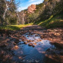
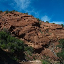
Simi Valley has one of those landscapes that calls you to explore. The rocky landscape is a seemingly endless hikers playground. This 2.3 mile trail is located over the southern section of Rocky Peak Park. You'll start by descending down the mountain until you reach dry Hummingbird creek. From there you'll gradually climb your way up to the top of the mountain. Along the way you'll pass by large and small sandstone outcroppings. It's a choose-your-adventure sorta hike where there are plenty of opportunities for you to break-off from the main trail and explore any number of side trails, caves and rock shelters and even an out-of-place palm tree oasis. The landscape gets even more interesting the further you go. The trail eventually meets up with the main Rocky Peak Trail which extends the length of the park and travels in a north/south direction. I think the key is to visit during cooler weather conditions. That obviously will make it a more enjoyable hike. It's also mostly sun exposed so I recommend that you wear a hat. Parking was free and plentiful the day I visited. read more


5 years ago
Beautiful hike. The swing and the cave are awesome. We made the hike in the morning. Planning to come back again read more


5 years ago
This is a tough one when starting from the bottom at keuhner. Overall, this hike is a great challenge due to its incline. Unfortunately, we were unable to find the graffiti cave with the swing but we did come across a cute and fierce deer. Bring plenty of water if hiking during the summer as there is not much shade read more


5 years ago
The hard trail which I've not hiked before. Parking on the street. Tried to read the reviews before I go there but I still got lost. . It took me a lot of time to go around and find the arrows and follow the ribbons. Finally, I got to the target by another girl. She found out the way to go to DOWN the cave, what I was looking forward to up to the top of the hill. My feet and my knees got hurt after the trail but you pay for what you want. read more


What a beautiful Oasis here in Simi. Spring is obviously when you want to visit. So Green and great views of the entire area. This I would rate as moderate to difficult as there are some steep spots and rocks that can be slippery. But for me it was moderate. There was water flowing in a couple different areas. I imagine that is mostly seasonal. When you see those palms..you've reached the Oasis. Easy and quick walk off the main trail. When you arrive, be sure to take a rest on the nice, flat rocks and listen to the adorable creek. It really is a special, little spot. Enjoy. It was a busy trail on a Sunday. read more

4 years ago
5 years ago
4 years ago
Make sure to bring your good knees for this hike along with a comfortable pair of hiking shoes/boots. The inclines, declines and terrain present a good challenge in some areas. The beautiful landscape and views of the valley are incredible and worth the trek, I'm a fan of graffiti art and nature so admittedly I'm conflicted by the the swing cave but it is still super cool. All in all if your looking for a challenge with beautiful views and payoff in the form of a unique rest stop this is a great trail to hit up. read more


4 years ago
7 years ago
7 years ago
Fun trail that merges into Rocky Peak or Las Llajas/Chumash (going the opposite direction). There is a really awesome place to stop at the top just to sit and see everything. The trial is fairly easy to hike up but going back down can be more difficult (depending on recent weather/terrain conditions) and requires much more balance and coordination. Because I have no balance nerve on my left side (and always seem to do this hike rehabbing LOL) I often find doing a "soft landing" a better option than risking an actual fall. One of these days I will try to remember to video one of those... Im sure they look hilarious! read more

8 years ago
8 years ago
5 years ago
8 years ago


8 years ago
I personally love being adventurous and spontaneous. I love the thrill of rock climbing and running through caves. If you go make sure to bring at least 3 cold water bottles for yourself. Bring a little snack too! If you go outside the trail be careful with snakes. Wear long socks and a sweater Because youll be going thru some bushes. NO SHORTS! If this is your first time going to the cave with a swing take the trail. read more


8 years ago
This trail was really nice! I liked it a lot but I didn't find the sing or the cave with graffiti, there's a lot of rocks so make sure you wear your hiking shoes! I'll have to come back again to find it! read more

Page 1 of 2
More info about Hummingbird Trail
2409-2435 Kuehner Dr
Simi Valley, CA 93063
Directions
(805) 584-4400
Call Now
Hours
Indoor Amenities
Outdoor Amenities
Ask the Community - Hummingbird Trail
Review Highlights - Hummingbird Trail
You might also consider


Hummingbird Trail - hiking - Updated July 2026
Best of Simi Valley
People found Hummingbird Trail by searching for…
Hiking Trails With Waterfalls in Simi Valley, California
Parks in Simi Valley, California
Beautiful Views in Simi Valley, California
Places to Take Pictures in Simi Valley, California
Scenic View in Simi Valley, California
Sunrise Hike in Simi Valley, California
Hiking Groups in Simi Valley, California
Dirt Bike Riding in Simi Valley, California
Rock Climbing in Simi Valley, California
Watch Sunset in Simi Valley, California
Things to Do in Simi Valley, California
Scenic Overlook in Simi Valley, California
Secret Spots in Simi Valley, California
Off Road Trails in Simi Valley, California
Photo Spots in Simi Valley, California
Flower Fields in Simi Valley, California
Running Trails in Simi Valley, California
Hiking Trails Kid Friendly in Simi Valley, California
Attractions in Simi Valley, California
Walking Trails in Simi Valley, California
Things to Do on a Sunday in Simi Valley, California
Shaded Hike in Simi Valley, California
Trending Searches in Simi Valley, CA
4th Of July Fireworks in Simi Valley, CA
Black Owned Nail Salons in Simi Valley, CA
Boat Rental in Simi Valley, CA
Cliff Jumping in Simi Valley, CA
Dog Friendly Trails in Simi Valley, CA
Jet Ski Rental in Simi Valley, CA
Kayak Rental in Simi Valley, CA
Lakes & Ponds in Simi Valley, CA
Outdoor Activities in Simi Valley, CA
Places To Walk Around in Simi Valley, CA
Public Pools in Simi Valley, CA
Public Shower in Simi Valley, CA
Rock Quarry in Simi Valley, CA
Running Trails in Simi Valley, CA
Scenic Night View in Simi Valley, CA
Scenic Overlook in Simi Valley, CA
Secluded Spots in Simi Valley, CA
Soccer Store in Simi Valley, CA
Strawberry Picking in Simi Valley, CA
Sunrise View in Simi Valley, CA
Swimming Holes in Simi Valley, CA
Swimming Lakes in Simi Valley, CA
Swimming Pools in Simi Valley, CA
Watch Sunset in Simi Valley, CA
Browse Articles
Browse Nearby
BEST of Simi Valley, California Coffee near Hummingbird Trail
BEST of Simi Valley, California Restaurants near Hummingbird Trail
BEST of Simi Valley, California Things to Do near Hummingbird Trail
BEST of Simi Valley, California Walking Trails near Hummingbird Trail
BEST of Simi Valley, California Breakfast near Hummingbird Trail
BEST of Simi Valley, California Parks near Hummingbird Trail
BEST of Simi Valley, California Campgrounds near Hummingbird Trail
BEST of Simi Valley, California Ski Resorts near Hummingbird Trail
BEST of Simi Valley, California Motel near Hummingbird Trail
Browse Brands
Related Searches in Simi Valley, CA
Best Fishing Locations and Guides in Simi Valley, California
Best Nature Trails for Hiking in Simi Valley, California
Best Places for Horseback Riding in Simi Valley, California
Best Waterfalls and Swimming Holes in Simi Valley, California
Check Out Off Road Trails in Simi Valley, California
Discover Dog Friendly Trails to Explore in Simi Valley, California
Discover Kid Friendly Hiking Trails in Simi Valley, California
Discover Scenic Hiking Trails in Simi Valley, California
Discover Scenic Mountain Bike Trails Near Simi Valley, California
Discover Scenic Waterfall Spots in Simi Valley, California
Discover Walking Parks in Simi Valley, California Near You
Discover a Hiking Trail in Simi Valley, California
Discover the Best Night Hike Trails in Simi Valley, California
Discover the Best Running Track in Simi Valley, California
Dog-Friendly Hikes With Dogs in Simi Valley, California
Enjoy Camping Adventures Around Simi Valley, California
Enjoy Exciting Mountain Biking Adventures in Simi Valley, California
Enjoy Kayaking Adventures in Simi Valley, California
Enjoy Tent Camping Spots Around Simi Valley, California
Enjoy a Beautiful Waterfall Hike in Simi Valley, California
Enjoy a Peaceful Nature Walk in Simi Valley, California
Enjoy the Best Walking Path in Simi Valley, California
Enjoy the Best Walking Trails in Simi Valley, California
Exciting Cliff Jumping Spots in Simi Valley, California
Explore Beautiful Parks and Green Spaces in Simi Valley, California
Explore Easy Hikes Perfect for All in Simi Valley, California
Explore Fun Activities to Do in Simi Valley, California
Explore Popular Campgrounds Near Simi Valley, California
Explore the Best Beach Spots in Simi Valley, California
Explore the Best Swimming Holes Around Simi Valley, California
Explore the Best Trail Options in Simi Valley, California
Family Friendly Hiking With Kids in Simi Valley, California
Find Beautiful Views in Simi Valley, California
Find the Best Parks for Picnics in Simi Valley, California
Find the Best Scenic View Locations in Simi Valley, California
Great Places to Walk in Simi Valley, California
Hike the Popular Waterfall Trail in Simi Valley, California
Hiking Trails With Waterfalls in Simi Valley, California
Off Leash Dog Hiking Trails in Simi Valley, California
Plan a Scenic Drive Route Near Simi Valley, California
Popular Outdoor Activities to Try in Simi Valley, California
Popular Picnic Spots to Visit in Simi Valley, California
Safe River Swimming Areas in Simi Valley, California
Safe and Fun Parks for Kids in Simi Valley, California
Top Climbing Spots and Gyms in Simi Valley, California
Top Running Trails to Explore in Simi Valley, California
Top Swimming Lakes to Enjoy in Simi Valley, California
Top Swimming Spots and Pools in Simi Valley, California
Walk Dog Friendly Hiking Trails in Simi Valley, California
Walk the Best Paved Walking Trails in Simi Valley, California
People who viewed Hummingbird Trail also viewed
Rocky Peak Park
62 reviews
Cave of Munits
95 reviews
Big Sky Trail
10 reviews
Corriganville Park
47 reviews
Mario DeCampos Trail
46 reviews
Granada Hills
Mount McCoy Cross
28 reviews
Cheeseboro and Palo Comado Canyon
34 reviews
Chumash Trail
8 reviews
O'Melveny Park
273 reviews
Granada Hills
Wilson Canyon Park
25 reviews
Sylmar