Cancel

    Open app

    Search

    Horseshoe Pond

    4.0 (1 review)

    Horseshoe Pond Photos
    Recommended Reviews - Horseshoe Pond

    Your trust is our priority, so businesses can't pay to alter or remove their reviews. Learn more about reviews.
    Yelp app icon
    Browse more easily on the app
    Review Feed Illustration
    Photo of Kevin S.
    80
    251
    41

    16 years ago

    Helpful 3
    Thanks 2
    Love this 3
    Oh no 0

    Verify this business for free

    People searched for Lakes 861 times last month within 15 miles of this business.

    Verify this business

    Goosefeather Pond

    Goosefeather Pond

    3.0
    (1 review)
    0.9 mi

    Good luck finding this pond. I'll help, if I can. From Oak Hill Road, you can only head east on…read moreScobie Road. About a quarter mile down, on the left, is a tiny pull-out, just enough for two cars, with an even tinier sign that reads "Goosefeather Pond." You'll drive right by it, I know. I have, and I already KNOW where it is. If you get to the "Giant Field of Antennae" you'll know you've gone too far. (With all those towers, I can't help but sing the Tom Waits song, "What's He Building In There?" I'm pretty sure he bought the thousand-pack of "No Trespassing" signs. Sheesh, we get it. Stay out. Okay, okay.) Walk about a hundred yards straight south from the "parking area" and you'll see Goosefeather. The dam is at the opposite end, and that's the deeper end. Very quiet, private, serene. A private residence is just to the west; they have a short bit of frontage on the pond, too. Stay clear of their property, if in fact it IS their property... Look for the trail to the east of the little parking lot; I made the mistake of heading right toward the lake and discovered the swamp instead. The fishing is un-spectacular with all the usual suspects: bluegills, perch, bluegill, sunfish and bluegill. There may be bass; I'll have to go back and check. One of the park service's finest was carefully manicuring the lawn by the dam, just in case anyone else can find this place. Aside from sitting on the grass or fishing, there really isn't much more this spot has to offer. Bird-watching, I suppose. Navel-gazing. Woogling, if you're careful.

    Pine Lane Trailhead

    Pine Lane Trailhead

    4.0
    (2 reviews)
    1.6 mi

    Pine Lane Trailhead sits just off Route 303 east of Peninsula. The small parking lot used to have…read morea bathroom, but that has been shut down a year ago. From the trailhead there are a number of options since the Buckeye Trail and the Valley Bridal Trail intersect at the parking lot. There is a small notice board with a local map and any relevant notices. Most people head North out of the lot. The Buckeye Trail rambles up and down and back and forth with a more moderate grade for most of it. You can follow the Buckeye Trail about 5 miles to Boston where you can return on the Towpath Trail. Going the other direction on the Buckeye Trail you will follow an abandoned road west that will take you to Peninsula, this is a somewhat boring portion of the trail, just a long straight downhill on a decaying pavement. The Bridal Trail is a more challenging trail for the first mile and a half at which point it becomes much straighter and more level until you get near Boston Mills Road at which point it heads west along the side of the Turnpike until you get to the Towpath Trail; this is a rather ugly hike and can be very exposed to the sun on a hot day. Going south on the Bridal Trail you cross 303 and follow the trail for a bit until it turns into a forest road that will take you all the way to S. Locust Road south of Peninsula. There is also a side trail off of the Buckeye Trail just after you have crossed the creek which follows the creek for a while, crosses a log bridge and then connects to the abandoned portion of Akron Peninsula Road that ends at the lumbar yard at the north end of Peninsula; this allows you to put together interesting loops using the towpath trail. From Pine Lane Trailhead you can put together several different loops ranging from a couple of miles to about 8 miles. Most of the trails have some nice climbs and descents including some really challenging parts on the Bridal Trail. You will stay mainly in the woods, although there are a number of different types of forests. These loops provide some very nice hiking and usually there are not a lot of people on the trails. The only real downside of these hikes is that there are a few portions with quite a bit of traffic noise, especially when you get close to the turnpike. Overall a good place to get out and enjoy the National Park. I have done these routes in various seasons and you do need to consider avoiding the Bridal Trail from north of Pine Lane until you cross the stream after it has been raining as this trail can be very muddy.

    It's been a while since I hiked a great trail in the Cleveland area or Ohio in general. My wife…read moreabsolutely loves this trail when she gets the opportunity to come back home. Easy access from the road with a fair amount of parking. We followed the Buckeye Trail from start to finish and it took about 2 hours to complete. Great condition for mid November. You'll traverse some lakes and various elevations throughout the hike. Didn't observe much wildlife or even horses on the trail but encounters with very friendly people that love casually coming here nearby. Solid trail, clean restrooms too!

    Photos
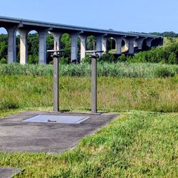
    Valley Bridal Trail view of Turnpike Bridge
    Valley Bridal Trail view of Turnpike Bridge
    Towpath Trail by Stumpy Basin

    See all

    Towpath Trail by Stumpy Basin

    Horseshoe Pond - lakes - Updated August 2026

    Loading...
    Loading...
    Loading...