Towpath Trail Photos


More like Towpath Trail
Recommended Reviews - Towpath Trail
Start your review...

Reviews With Photos

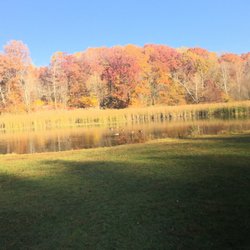
Ready, Set, Lets Ride! The Ohio & Erie Canal Towpath Trail is a multipurpose active trail for bicyclists, walkers, runners and, in some places, horseback riders. If you enjoy the outdoors, an active lifestyle, natural offerings and just peace of mind, come here. Towpath Trail begins in the city of Massillon and goes north into Cleveland. The trail runs through the Stark County Park District, Summit Metro Parks and Cuyahoga Valley National Park. Weekdays are best for avoiding the crowds and feeling the spaciousness of nature. We picked the perfect summer day for a bike ride. We began in Akron at the Mustill Store, on North Street, near where the Cuyahoga Valley Scenic Railroad (CVSR) begins or ends, depending on your location. There is ample parking in the adjacent lot. Our plan was to bike one way north and return by CVSR. CVSR offers cyclists boarding & bike loading for the low cost of $3 one way. (Runners and hikers are eligible) Beware though, the train technically only loads bikes at Akron Northside, Peninsula and Rockside (lock 39) stations. At the other stations, you have to clearly/actively flag them down or they will pass you by. Be sure to get a schedule for the train so you aren't left stranded somewhere in the woods. Admittedly, there were a number of park rangers visible to provide information and assistance. When we first started on Towpath, I was somewhat concerned because I didn't see the tracks. But that was only for the first few miles. The tracks are to the left and the canal is to the right as you are headed north. Along the trail you will see many mile markers, station signs and historical information about the canal area. For your viewing pleasure are forests, fields, flowers, plants, wetlands, bridges and wildlife such as hawks, beavers, herons and frogs. At different points, the trail is either paved, graveled or planked. This is not a difficult ride as the terrain is mostly flat. Bicycle rentals are offered somewhere along the trail. Also, there are many rest stops, some stores and restaurants for eating, drinking and shopping. At one point we saw a farmers market and ice cream shop. As a side note, the restroom facilities are some of the best I have encountered: modern, clean, odor-free, lots of soap and paper products. Yipee! After approximately 3 hours and 27.5 miles of bike riding and another 75 minutes on the train our mission was accomplished. Oh happy trails. Worth toasting to. Must plan another ride soon.

8 months ago


Walking path near the Cleveland script sign that's is moderately easy and takes you down by the lake. Scenery isn't the greatest as lots of warehouses around and it does not appear as anybody takes care of the landscape there. But it was a peaceful and relaxing walk. read more


Walking path in Cleveland next to the river and small salt mines. It's not very well kept and not too many people by walk on her visited me up buddy got a lot of stuff said they walked around the whole thing so it was cool to see but I need some work read more

Ready, Set, Lets Ride! The Ohio & Erie Canal Towpath Trail is a multipurpose active trail for bicyclists, walkers, runners and, in some places, horseback riders. If you enjoy the outdoors, an active lifestyle, natural offerings and just peace of mind, come here. Towpath Trail begins in the city of Massillon and goes north into Cleveland. The trail runs through the Stark County Park District, Summit Metro Parks and Cuyahoga Valley National Park. Weekdays are best for avoiding the crowds and feeling the spaciousness of nature. We picked the perfect summer day for a bike ride. We began in Akron at the Mustill Store, on North Street, near where the Cuyahoga Valley Scenic Railroad (CVSR) begins or ends, depending on your location. There is ample parking in the adjacent lot. Our plan was to bike one way north and return by CVSR. CVSR offers cyclists boarding & bike loading for the low cost of $3 one way. (Runners and hikers are eligible) Beware though, the train technically only loads bikes at Akron Northside, Peninsula and Rockside (lock 39) stations. At the other stations, you have to clearly/actively flag them down or they will pass you by. Be sure to get a schedule for the train so you aren't left stranded somewhere in the woods. Admittedly, there were a number of park rangers visible to provide information and assistance. When we first started on Towpath, I was somewhat concerned because I didn't see the tracks. But that was only for the first few miles. The tracks are to the left and the canal is to the right as you are headed north. Along the trail you will see many mile markers, station signs and historical information about the canal area. For your viewing pleasure are forests, fields, flowers, plants, wetlands, bridges and wildlife such as hawks, beavers, herons and frogs. At different points, the trail is either paved, graveled or planked. This is not a difficult ride as the terrain is mostly flat. Bicycle rentals are offered somewhere along the trail. Also, there are many rest stops, some stores and restaurants for eating, drinking and shopping. At one point we saw a farmers market and ice cream shop. As a side note, the restroom facilities are some of the best I have encountered: modern, clean, odor-free, lots of soap and paper products. Yipee! After approximately 3 hours and 27.5 miles of bike riding and another 75 minutes on the train our mission was accomplished. Oh happy trails. Worth toasting to. Must plan another ride soon. read more


10 years ago
One of my absolute favorite things to do in Cleveland. My hubby, son and I took off for the towpath trail again this weekend and it was as beautiful and fun as we remembered. The towpath is a multi-use trail that offers biking, running, walking/hiking, equestrian, even snow mobile trails! We chose to bike from the Rockside Station to Brecksville Station. The towpath coincides with the Cuyahoga Valley Scenic Railroad which allows you to take advantage of the towpath as well as the train which is a real treat! Both times we biked the path we used the Bike Aboard Program; for just $3 you can bike the trail and then board the train at any of the stations. The attendants on the train will stow your bike in a separate train-car and you get to ride in the car for Bike Aboard riders. Its a great program that I encourage everyone to take advantage of. I cannot overstate how BEAUTIFUL the towpath trail is, on your ride/walk/hike you'll be surrounded by beautiful scenic wooded areas, running water, wildflowers, and historical points of interest. The trails are well maintained and clean...I would go as far as to say pristine. Placed throughout are benches for resting or just taking in the environment. Its a great way to spend the day. There is also the Trail Mix stores where you can get food and other things, the first time we stopped at the Trail Mix in Boston Mills and had Mitchell's Ice Cream. There are chairs and benches there where you can sit and take it all in. The trail is perfect for families and for all activity levels as you can choose to go at your own pace and both times we saw people of all ages enjoying the outdoors. I would recommend the Towpath Trail to anyone looking for some outdoor activity and looking for beautiful places and spaces in Cleveland. read more

6 years ago
5 years ago
More info about Towpath Trail
Ask the Community - Towpath Trail
Review Highlights - Towpath Trail


Why does Yelp recommend reviews?
Towpath Trail - hiking - Updated June 2026
Best of Clevand
People found Towpath Trail by searching for…
Flower Fields in Clevand, Ohio
Running Trails in Clevand, Ohio
Hiking Trails in Clevand, Ohio
Swimming Lakes in Clevand, Ohio
Walking Trails in Clevand, Ohio
Places to Take Pictures in Clevand, Ohio
Mountain Biking in Clevand, Ohio
Off Road Trails in Clevand, Ohio
Beautiful Views in Clevand, Ohio
Browse Nearby
BEST of Clevand, Ohio Coffee near Towpath Trail
BEST of Clevand, Ohio Restaurants near Towpath Trail
BEST of Clevand, Ohio Things to Do near Towpath Trail
BEST of Clevand, Ohio Parks near Towpath Trail
BEST of Clevand, Ohio Breakfast near Towpath Trail
BEST of Clevand, Ohio Photo Spots near Towpath Trail
Browse Brands
Browse Articles
People who viewed Towpath Trail also viewed
Viaduct Park
11 reviews
Great Falls of Tinker's Creek
9 reviews
Lock 29
6 reviews
Eldon Russell Park
4 reviews
Canalway Center-Cleveland Metroparks
5 reviews
Sand Run Metro Park
9 reviews
Portage Hike & Bike Trail
1 review
Franklin Mills Riveredge Park
2 reviews
Chagrin Water Falls
53 reviews
Sunny Lake Park
9 reviews