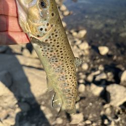
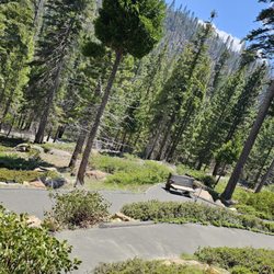
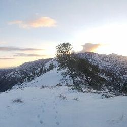
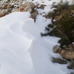
Hooper Hill Trailhead Photos


You might also consider
More like Hooper Hill Trailhead
Recommended Reviews - Hooper Hill Trailhead
Start your review...

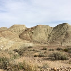
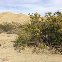
This trailhead looks like a dirt turnout from Caliente Bodfish Rd (County Rd 483). The trailhead is located at lat/long coordinates 35.569589,-118.506856. If you copy and paste those coordinates into Google Maps, it will give you the exact location. To start the hike, you have to go past a barbed wire fence gate and head north up a steep incline to the ridge. Once on the ridge, walk back south to the summit (located at 35.567219, -118.512666). It is a short hike (~2 miles) with an elevation gain of 670 feet. This is a great little hike that is suitable for beginners and children or anyone looking to get out for a quick morning hike. read more


6 years ago
6 years ago
More info about Hooper Hill Trailhead
Caliente Bodfish Rd
Bodfish, CA 93205
Directions
Hours
Outdoor Amenities
You might also consider


Hooper Hill Trailhead - hiking - Updated July 2026
Best of Bodfish
People found Hooper Hill Trailhead by searching for…
Things to Do in Bodfish, California
Hiking Trails in Bodfish, California
Off Road Trails in Bodfish, California
Hiking With Kids in Bodfish, California
Waterfalls in Bodfish, California
Walking Trails in Bodfish, California
Beautiful Views in Bodfish, California
Lakes & Ponds in Bodfish, California
Easy Hikes in Bodfish, California
Running Trails in Bodfish, California
View Points in Bodfish, California
Swimming Holes in Bodfish, California
Watch Sunset in Bodfish, California
Scenic View in Bodfish, California
Stair Climbing in Bodfish, California
Places to Go in Bodfish, California
Tent Camping in Bodfish, California
Free Campgrounds in Bodfish, California
Playground in Bodfish, California
Fitness & Instruction in Bodfish, California
Trending Searches in Bodfish, CA
Boat Rental near Hooper Hill Trailhead
Cliff Jumping near Hooper Hill Trailhead
Dog Friendly Trails near Hooper Hill Trailhead
Jet Ski Rental near Hooper Hill Trailhead
Kayak Rental near Hooper Hill Trailhead
Public Shower near Hooper Hill Trailhead
River Swimming near Hooper Hill Trailhead
River Tubing near Hooper Hill Trailhead
Running Trails near Hooper Hill Trailhead
Splash Pad near Hooper Hill Trailhead
Swimming Holes near Hooper Hill Trailhead
Swimming Lakes near Hooper Hill Trailhead
Swimming Pools near Hooper Hill Trailhead
Watch Sunset near Hooper Hill Trailhead
Browse Articles
Browse Nearby
BEST of Bodfish, California Parks near Hooper Hill Trailhead
BEST of Bodfish, California Things to Do near Hooper Hill Trailhead
BEST of Bodfish, California Restaurants near Hooper Hill Trailhead
BEST of Bodfish, California Coffee near Hooper Hill Trailhead
BEST of Bodfish, California Breakfast near Hooper Hill Trailhead
BEST of Bodfish, California Fishing near Hooper Hill Trailhead
BEST of Bodfish, California Hot Springs near Hooper Hill Trailhead
BEST of Bodfish, California Campgrounds near Hooper Hill Trailhead
Browse Brands
Related Searches in Bodfish, CA
Affordable Kayak Rental Services in Bodfish, California
Best Fishing Locations and Guides in Bodfish, California
Best Places for Horseback Riding in Bodfish, California
Best Spots for Star Gazing in Bodfish, California
Check Out Off Road Trails in Bodfish, California
Discover Dog Friendly Trails to Explore in Bodfish, California
Discover a Hiking Trail in Bodfish, California
Discover the Best Night Hike Trails in Bodfish, California
Dog-Friendly Hikes With Dogs in Bodfish, California
Enjoy Camping Adventures Around Bodfish, California
Enjoy Kayaking Adventures in Bodfish, California
Enjoy River Tubing Adventures in Bodfish, California
Enjoy Tent Camping Spots Around Bodfish, California
Enjoy the Best Tubing Experiences in Bodfish, California
Exciting Cliff Jumping Spots in Bodfish, California
Experience Thrilling White Water Rafting in Bodfish, California
Explore Beautiful Parks and Green Spaces in Bodfish, California
Explore Bike Rentals Throughout Bodfish, California
Explore Easy Hikes Perfect for All in Bodfish, California
Explore Fun Activities to Do in Bodfish, California
Explore Popular Campgrounds Near Bodfish, California
Explore Popular RV Parks Around Bodfish, California
Explore Popular View Points Around Bodfish, California
Explore Scenic Lakes to Visit in Bodfish, California
Explore Secret Spots Worth Visiting in Bodfish, California
Explore Top Dog Parks in Bodfish, California Near You
Explore the Best Boating Spots in Bodfish, California
Explore the Best Swimming Holes Around Bodfish, California
Family Friendly Hiking With Kids in Bodfish, California
Find Top Dog Swimming Spots in Bodfish, California
Find Top Skate Parks in Bodfish, California for All Skill Levels
Find Top-Rated Disc Golf in Bodfish, California
Hiking Trails With Waterfalls in Bodfish, California
Locate a Public Shower Facility in Bodfish, California
Must-See Tourist Attractions Around Bodfish, California
Perfect Spots to Watch Sunset in Bodfish, California
Popular Fishing Spots to Explore in Bodfish, California
Popular Outdoor Activities to Try in Bodfish, California
Popular Picnic Spots to Visit in Bodfish, California
Popular Things to Do in Bodfish, California
Relax at Natural Hot Springs Near Bodfish, California
Safe River Swimming Areas in Bodfish, California
Safe and Fun Parks for Kids in Bodfish, California
Top Paddleboarding Activities in Bodfish, California
Top Running Trails to Explore in Bodfish, California
Top Swimming Spots and Pools in Bodfish, California
Top Things to Do With Kids in Bodfish, California
Top-Rated Boat Rental Services in Bodfish, California